
New York State Route 309
Encyclopedia
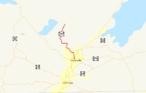
New York State Route 309 (NY 309) is a state highway
located entirely in Fulton County, New York
, in the United States
. The southern terminus of the route is at an intersection with NY 29A
in Gloversville
. The northern terminus of the route is at a junction with Lily Lake Road in the hamlet of Bleecker, where the highway continues north and west as County Route 112 (CR 112) to London Bridge Road (CR 111, near NY 10
and NY 29A) at West Caroga Lake in the town of Caroga
. Part of NY 309 and all of CR 112 is located within Adirondack Park. NY 309 was assigned to its current alignment as part of the 1930 renumbering of state highways in New York.
in downtown Gloversville
. The route heads northward as Bleecker Street, passing large commercial buildings as it heads north through the city. At Spring Street—two blocks north of NY 29A—the surroundings become more residential as the commercial structures are replaced by homes. The route continues on, crossing Cayadutta Creek between 8th Avenue and McLaren Street before leaving Bleecker Street at 11th Avenue to follow an unnamed western extension of 11th Avenue. At this point, the amount of development along NY 309 drops substantially as it parallels Cayadutta Creek and heads northwestward out of the city limits. At this point, maintenance of the route shifts from the city of Gloversville to the New York State Department of Transportation
(NYSDOT).
 Now in the town of Johnstown
, the route winds its way northwestward as it follows Cayadutta Creek through an area of hilly terrain south of Adirondack Park. Development along the route largely ends at the intersection with West State Street; however, a pair of isolated homes are situated on NY 309 about 0.25 mile (0.402335 km) to the northeast ahead of an intersection with CR 122, an east–west highway that serves the Fulton County Infirmary a short distance to the west. The route continues to wind its way through the mountains to the hamlet of West Bush, where Cayadutta Creek ends amidst a small cluster of houses. The route turns north at this point, passing a handful of homes before leaving the community upon passing through a narrow pass between two hills.
North of West Bush, the route rapidly ascends in elevation as it climbs up the side of a large mountain. Along this stretch, the route veers to the northwest and southeast as it heads through an area of wilderness. NY 309 crosses the Blue Line
into Adirondack Park near the mountain's summit. Upon reaching the top of the mountain, the highway straightens out and heads northward for roughly 0.5 mile (0.80467 km) across the hill's plateau. Upon reaching the other side, the road gradually descends in elevation as it passes by Mountain Lake
and enters the town of Bleecker
. The highway continues its northeastward descent into the small lakeside hamlet of Bleecker, where NY 309 ends at an intersection with Lily Lake Road. At this point, the roadway becomes CR 112.
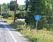 CR 112 heads northwest from Bleecker, passing Peck Lake to the northeast and Lily Lake to the southwest as it winds its way around several small hills. After 2 miles (3.2 km), the route curves to the north and serves Bleecker Center, an isolated hamlet centered at the junction of CR 112 and CR 145. The former continues northwest across relatively low-lying areas to Peters Corners, an equally isolated hamlet located at the intersection of CR 112 and CR 125. CR 112 turns southwest here and begins to climb up the side of a small mountain overlooking Peters Corners.
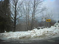
As the route heads west, it runs along the base of Hogback, a large mountain with two peaks that reach over 2400 feet (731.5 m) in elevation. Past Hogback, CR 112 enters the town of Caroga
, where the route heads west across nearly flat terrain to the hamlet of Caroga Lake. CR 112 bypasses most of the hamlet to the north; as a result, it passes through only lightly developed areas as the route nears its end. CR 112 intersects NY 10
and NY 29A just 70 feet (21.3 m) from where it officially ends at an intersection with CR 111, which itself begins at NY 10 and NY 29A just 80 yards (73.2 m) to the south.
_route_112_map.png) Part of CR 112 was originally part of an old Indian trail that went from Johnstown
Part of CR 112 was originally part of an old Indian trail that went from Johnstown
to Hamilton County
via Bleecker. At some point, part of the trail in the vicinity of Bleecker was converted into a plank road
that served several locations and churches north of Bleecker. Meanwhile, NY 309 was assigned as part of the 1930 renumbering of state highways in New York to a connector highway between the city of Gloversville
and the hamlet of Bleecker.
State highway
State highway, state road or state route can refer to one of three related concepts, two of them related to a state or provincial government in a country that is divided into states or provinces :#A...
located entirely in Fulton County, New York
Fulton County, New York
Fulton County is a county located in the U.S. state of New York. As of the 2010 census, the population was 55,531. Its name is in honor of Robert Fulton, who is widely credited with developing the first commercially successful steamboat...
, in the United States
United States
The United States of America is a federal constitutional republic comprising fifty states and a federal district...
. The southern terminus of the route is at an intersection with NY 29A
New York State Route 29A
New York State Route 29A is a state highway in the western portion of the Capital District of New York in the United States. The western terminus of the route is at an intersection with NY 29 in the Herkimer County hamlet of Salisbury Center. Its eastern end is at another junction with...
in Gloversville
Gloversville, New York
Gloversville is a city in Fulton County, New York, that was once the hub of America's glovemaking industry with over two hundred manufacturers in Gloversville and Johnstown. In 2000, Gloversville had a population of 15,413. Ten years later, the population had increased to 15,665- History :The...
. The northern terminus of the route is at a junction with Lily Lake Road in the hamlet of Bleecker, where the highway continues north and west as County Route 112 (CR 112) to London Bridge Road (CR 111, near NY 10
New York State Route 10
New York State Route 10 is a north–south state highway in the Central New York and North Country regions of New York in the United States. It extends for from the Quickway in Deposit, Delaware County to NY 8 at Higgins Bay, a hamlet in the Hamilton County town of Arietta...
and NY 29A) at West Caroga Lake in the town of Caroga
Caroga, New York
Caroga is a town in Fulton County, New York, USA. The population was 1,407 at the 2000 census. The town was named after a local creek.The Town of Caroga is in the northern part of the county and is north of Gloversville and Johnstown....
. Part of NY 309 and all of CR 112 is located within Adirondack Park. NY 309 was assigned to its current alignment as part of the 1930 renumbering of state highways in New York.
NY 309
NY 309 begins at an intersection with NY 29ANew York State Route 29A
New York State Route 29A is a state highway in the western portion of the Capital District of New York in the United States. The western terminus of the route is at an intersection with NY 29 in the Herkimer County hamlet of Salisbury Center. Its eastern end is at another junction with...
in downtown Gloversville
Gloversville, New York
Gloversville is a city in Fulton County, New York, that was once the hub of America's glovemaking industry with over two hundred manufacturers in Gloversville and Johnstown. In 2000, Gloversville had a population of 15,413. Ten years later, the population had increased to 15,665- History :The...
. The route heads northward as Bleecker Street, passing large commercial buildings as it heads north through the city. At Spring Street—two blocks north of NY 29A—the surroundings become more residential as the commercial structures are replaced by homes. The route continues on, crossing Cayadutta Creek between 8th Avenue and McLaren Street before leaving Bleecker Street at 11th Avenue to follow an unnamed western extension of 11th Avenue. At this point, the amount of development along NY 309 drops substantially as it parallels Cayadutta Creek and heads northwestward out of the city limits. At this point, maintenance of the route shifts from the city of Gloversville to the New York State Department of Transportation
New York State Department of Transportation
The New York State Department of Transportation is responsible for the development and operation of highways, railroads, mass transit systems, ports, waterways and aviation facilities in the U.S...
(NYSDOT).
Johnstown (town), New York
Johnstown is a town located in Fulton County, New York, United States. As of the 2000 U.S. Census, the town had a population of 7,166. The name of the town is from landowner William Johnson....
, the route winds its way northwestward as it follows Cayadutta Creek through an area of hilly terrain south of Adirondack Park. Development along the route largely ends at the intersection with West State Street; however, a pair of isolated homes are situated on NY 309 about 0.25 mile (0.402335 km) to the northeast ahead of an intersection with CR 122, an east–west highway that serves the Fulton County Infirmary a short distance to the west. The route continues to wind its way through the mountains to the hamlet of West Bush, where Cayadutta Creek ends amidst a small cluster of houses. The route turns north at this point, passing a handful of homes before leaving the community upon passing through a narrow pass between two hills.
North of West Bush, the route rapidly ascends in elevation as it climbs up the side of a large mountain. Along this stretch, the route veers to the northwest and southeast as it heads through an area of wilderness. NY 309 crosses the Blue Line
Blue Line (New York State)
The Blue Line is the term used in New York state for the boundaries of the Adirondack and Catskill parks, within which can be found the state's Forest Preserve...
into Adirondack Park near the mountain's summit. Upon reaching the top of the mountain, the highway straightens out and heads northward for roughly 0.5 mile (0.80467 km) across the hill's plateau. Upon reaching the other side, the road gradually descends in elevation as it passes by Mountain Lake
Mountain Lake (New York)
Mountain Lake is a lake situated in southern Adirondack Park in Bleecker, New York. It is located just east of Great Sacandaga Lake. The lake was called Carpenter's Lake in the 19th century. The lake contains one small island, Elmer Island, located towards the western end. There is a dam on the...
and enters the town of Bleecker
Bleecker, New York
Bleecker is a town in Fulton County, New York, USA. The population was 573 at the 2000 census. The name is from Barent Bleecker, one of the original landowners of the region....
. The highway continues its northeastward descent into the small lakeside hamlet of Bleecker, where NY 309 ends at an intersection with Lily Lake Road. At this point, the roadway becomes CR 112.
CR 112
As the route heads west, it runs along the base of Hogback, a large mountain with two peaks that reach over 2400 feet (731.5 m) in elevation. Past Hogback, CR 112 enters the town of Caroga
Caroga, New York
Caroga is a town in Fulton County, New York, USA. The population was 1,407 at the 2000 census. The town was named after a local creek.The Town of Caroga is in the northern part of the county and is north of Gloversville and Johnstown....
, where the route heads west across nearly flat terrain to the hamlet of Caroga Lake. CR 112 bypasses most of the hamlet to the north; as a result, it passes through only lightly developed areas as the route nears its end. CR 112 intersects NY 10
New York State Route 10
New York State Route 10 is a north–south state highway in the Central New York and North Country regions of New York in the United States. It extends for from the Quickway in Deposit, Delaware County to NY 8 at Higgins Bay, a hamlet in the Hamilton County town of Arietta...
and NY 29A just 70 feet (21.3 m) from where it officially ends at an intersection with CR 111, which itself begins at NY 10 and NY 29A just 80 yards (73.2 m) to the south.
History
Johnstown (city), New York
Johnstown is a city and the county seat of Fulton County in the U.S. state of New York. As of the 2000 Census, the city had population of 8,511. Recent estimates put the figure closer to 8,100. The city was named by its founder, Sir William Johnson after his son John Johnson...
to Hamilton County
Hamilton County, New York
Hamilton County is a county located in the U.S. state of New York. It is named after Alexander Hamilton, the only member of the New York State delegation who signed the United States Constitution in 1787 and later the first United States Secretary of the Treasury. Its county seat is Lake Pleasant...
via Bleecker. At some point, part of the trail in the vicinity of Bleecker was converted into a plank road
Plank road
A plank road or puncheon is a dirt path or road covered with a series of planks, similar to the wooden sidewalks one would see in a Western movie. Plank roads were very popular in Ontario, the U.S. Northeast and U.S. Midwest in the first half of the 19th century...
that served several locations and churches north of Bleecker. Meanwhile, NY 309 was assigned as part of the 1930 renumbering of state highways in New York to a connector highway between the city of Gloversville
Gloversville, New York
Gloversville is a city in Fulton County, New York, that was once the hub of America's glovemaking industry with over two hundred manufacturers in Gloversville and Johnstown. In 2000, Gloversville had a population of 15,413. Ten years later, the population had increased to 15,665- History :The...
and the hamlet of Bleecker.