
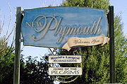
New Plymouth, Idaho
Encyclopedia
New Plymouth is a city in Payette County
, Idaho
, United States
. The population was 1,400 at the 2000 census. It was incorporated on February 15, 1896. It is the host of the annual Payette County Fair.
New Plymouth is part of the Ontario
, OR
–ID Micropolitan Statistical Area
.
, who in 1895 formed what they called "The Plymouth Society of Chicago" and William E. Smythe, who was the chairman of the executive committee of the National Irrigation Congress and a famous irrigation promoter. Mr. Smythe was determined to found a colony to serve as a striking argument in favor of his project - irrigation
. He spoke throughout the east, urging young and old men to go west in colonies and develop the country with the help of irrigation. He wanted the first colony to be called New Plymouth — after Plymouth, Massachusetts — and wanted it located in southwestern Idaho in the Payette Valley, which he had found apt for his purpose because of the extraordinary water supply via the nearby Payette River
.
The Plymouth Society of Chicago selected a committee to investigate the irrigated Payette River Valley in the five-year-old state of Idaho, and another site in Colorado
, to be purchased for the colony. The present city of New Plymouth was on the drawing boards in Chicago, designed as a town able to be self reliant through the use of irrigation, solidly built on an agricultural and railroad economy.
In February 1896, each colonist purchased 20 shares of stock at $30 per share, which entitled him to 20 acres (80,937.2 m²) of land and a town lot. He was to clear the land of sagebrush and plant fruit trees, preferably apples. The town was plat
ted with a horseshoe shape with its open end facing to the north, toward the railroad and the river. This area was planned as an industrial zone, and the acre tracts around the horseshoe were the residential lots.
The homes were to built on the street side and the balance of the acre for garden and pasture for the family cow and the driving team. Two streets, separated by an 80 feet (24.4 m) park, curve around the town in a horseshoe shape. This one-mile (1.6 km) long park and the streets that enclose it were called "The Boulevard
." The park was planted with grass and shade trees. Plymouth Avenue, the main street and principal business thoroughfare, was surveyed (16 feet off the section line) down the center of the horseshoe from the railroad on the north through the Boulevard on the south.
The community was at first called the New Plymouth Farm Village and was governed by a colony board of directors until it incorporated as a village
in 1908, dropping the last two words in the name. It was designated a city
in 1948.
According to the United States Census Bureau
, the city has a total area of 0.7 square miles (1.8 km²), all land.
of 2000, there were 1,400 people, 524 households, and 372 families residing in the city. The racial makeup of the city was 94.36% White, 0.29% African American, 0.79% Native American, 0.21% Asian, 2.86% from other races
, and 1.50% from two or more races. Hispanic or Latino of any race were 9.86% of the population.
There were 524 households out of which 38.0% had children under the age of 18 living with them, 56.1% were married couples
living together, 10.7% had a female householder with no husband present, and 29.0% were non-families. 25.6% of all households were made up of individuals and 13.7% had someone living alone who was 65 years of age or older. The average household size was 2.67 and the average family size was 3.23.
In the city the population was spread out with 31.7% under the age of 18, 6.7% from 18 to 24, 27.9% from 25 to 44, 18.6% from 45 to 64, and 15.1% who were 65 years of age or older. The median age was 34 years. For every 100 females there were 95.3 males. For every 100 females age 18 and over, there were 88.6 males.
The median income for a household in the city was $30,524, and the median income for a family was $33,224. Males had a median income of $28,529 versus $21,161 for females. The per capita income
for the city was $12,624. About 12.3% of families and 17.2% of the population were below the poverty line, including 25.9% of those under age 18 and 8.9% of those age 65 or over.
City Council members include Erik Cline, Ben Esplin, Jeannette Mayer, and Rick York.
Payette County, Idaho
Payette County is a county located in the U.S. state of Idaho. The county was established in 1917, and at the 2000 Census the county had a population of 20,578 . The county seat is Payette....
, Idaho
Idaho
Idaho is a state in the Rocky Mountain area of the United States. The state's largest city and capital is Boise. Residents are called "Idahoans". Idaho was admitted to the Union on July 3, 1890, as the 43rd state....
, United States
United States
The United States of America is a federal constitutional republic comprising fifty states and a federal district...
. The population was 1,400 at the 2000 census. It was incorporated on February 15, 1896. It is the host of the annual Payette County Fair.
New Plymouth is part of the Ontario
Ontario, Oregon
Ontario is the largest city in Malheur County, Oregon, United States. It lies along the Snake River at the Idaho border. The population was 10,985 at the 2000 census, with an estimated population of 11,245 in 2006...
, OR
Oregon
Oregon is a state in the Pacific Northwest region of the United States. It is located on the Pacific coast, with Washington to the north, California to the south, Nevada on the southeast and Idaho to the east. The Columbia and Snake rivers delineate much of Oregon's northern and eastern...
–ID Micropolitan Statistical Area
Ontario micropolitan area
The Ontario Micropolitan Statistical Area, as defined by the United States Census Bureau, is an area consisting of two counties – one in southeastern Oregon and one in southwestern Idaho, anchored by the city of Ontario....
.
History
New Plymouth was a colony town, bought and planned before it was settled. It was the combined project of a group of people purportedly dissatisfied with city life in ChicagoChicago
Chicago is the largest city in the US state of Illinois. With nearly 2.7 million residents, it is the most populous city in the Midwestern United States and the third most populous in the US, after New York City and Los Angeles...
, who in 1895 formed what they called "The Plymouth Society of Chicago" and William E. Smythe, who was the chairman of the executive committee of the National Irrigation Congress and a famous irrigation promoter. Mr. Smythe was determined to found a colony to serve as a striking argument in favor of his project - irrigation
Irrigation
Irrigation may be defined as the science of artificial application of water to the land or soil. It is used to assist in the growing of agricultural crops, maintenance of landscapes, and revegetation of disturbed soils in dry areas and during periods of inadequate rainfall...
. He spoke throughout the east, urging young and old men to go west in colonies and develop the country with the help of irrigation. He wanted the first colony to be called New Plymouth — after Plymouth, Massachusetts — and wanted it located in southwestern Idaho in the Payette Valley, which he had found apt for his purpose because of the extraordinary water supply via the nearby Payette River
Payette River
The Payette River is an river in southwestern Idaho and is a major tributary of the Snake River.Its headwaters originate in the Sawtooth and Salmon River Mountains at elevations over...
.
The Plymouth Society of Chicago selected a committee to investigate the irrigated Payette River Valley in the five-year-old state of Idaho, and another site in Colorado
Colorado
Colorado is a U.S. state that encompasses much of the Rocky Mountains as well as the northeastern portion of the Colorado Plateau and the western edge of the Great Plains...
, to be purchased for the colony. The present city of New Plymouth was on the drawing boards in Chicago, designed as a town able to be self reliant through the use of irrigation, solidly built on an agricultural and railroad economy.
In February 1896, each colonist purchased 20 shares of stock at $30 per share, which entitled him to 20 acres (80,937.2 m²) of land and a town lot. He was to clear the land of sagebrush and plant fruit trees, preferably apples. The town was plat
Plat
A plat in the U.S. is a map, drawn to scale, showing the divisions of a piece of land. Other English-speaking countries generally call such documents a cadastral map or plan....
ted with a horseshoe shape with its open end facing to the north, toward the railroad and the river. This area was planned as an industrial zone, and the acre tracts around the horseshoe were the residential lots.
The homes were to built on the street side and the balance of the acre for garden and pasture for the family cow and the driving team. Two streets, separated by an 80 feet (24.4 m) park, curve around the town in a horseshoe shape. This one-mile (1.6 km) long park and the streets that enclose it were called "The Boulevard
Boulevard
A Boulevard is type of road, usually a wide, multi-lane arterial thoroughfare, divided with a median down the centre, and roadways along each side designed as slow travel and parking lanes and for bicycle and pedestrian usage, often with an above-average quality of landscaping and scenery...
." The park was planted with grass and shade trees. Plymouth Avenue, the main street and principal business thoroughfare, was surveyed (16 feet off the section line) down the center of the horseshoe from the railroad on the north through the Boulevard on the south.
The community was at first called the New Plymouth Farm Village and was governed by a colony board of directors until it incorporated as a village
Village
A village is a clustered human settlement or community, larger than a hamlet with the population ranging from a few hundred to a few thousand , Though often located in rural areas, the term urban village is also applied to certain urban neighbourhoods, such as the West Village in Manhattan, New...
in 1908, dropping the last two words in the name. It was designated a city
City
A city is a relatively large and permanent settlement. Although there is no agreement on how a city is distinguished from a town within general English language meanings, many cities have a particular administrative, legal, or historical status based on local law.For example, in the U.S...
in 1948.
Geography
New Plymouth is located at 43°58′14"N 116°49′14"W (43.970689, -116.820449).According to the United States Census Bureau
United States Census Bureau
The United States Census Bureau is the government agency that is responsible for the United States Census. It also gathers other national demographic and economic data...
, the city has a total area of 0.7 square miles (1.8 km²), all land.
Demographics
As of the censusCensus
A census is the procedure of systematically acquiring and recording information about the members of a given population. It is a regularly occurring and official count of a particular population. The term is used mostly in connection with national population and housing censuses; other common...
of 2000, there were 1,400 people, 524 households, and 372 families residing in the city. The racial makeup of the city was 94.36% White, 0.29% African American, 0.79% Native American, 0.21% Asian, 2.86% from other races
Race (United States Census)
Race and ethnicity in the United States Census, as defined by the Federal Office of Management and Budget and the United States Census Bureau, are self-identification data items in which residents choose the race or races with which they most closely identify, and indicate whether or not they are...
, and 1.50% from two or more races. Hispanic or Latino of any race were 9.86% of the population.
There were 524 households out of which 38.0% had children under the age of 18 living with them, 56.1% were married couples
Marriage
Marriage is a social union or legal contract between people that creates kinship. It is an institution in which interpersonal relationships, usually intimate and sexual, are acknowledged in a variety of ways, depending on the culture or subculture in which it is found...
living together, 10.7% had a female householder with no husband present, and 29.0% were non-families. 25.6% of all households were made up of individuals and 13.7% had someone living alone who was 65 years of age or older. The average household size was 2.67 and the average family size was 3.23.
In the city the population was spread out with 31.7% under the age of 18, 6.7% from 18 to 24, 27.9% from 25 to 44, 18.6% from 45 to 64, and 15.1% who were 65 years of age or older. The median age was 34 years. For every 100 females there were 95.3 males. For every 100 females age 18 and over, there were 88.6 males.
The median income for a household in the city was $30,524, and the median income for a family was $33,224. Males had a median income of $28,529 versus $21,161 for females. The per capita income
Per capita income
Per capita income or income per person is a measure of mean income within an economic aggregate, such as a country or city. It is calculated by taking a measure of all sources of income in the aggregate and dividing it by the total population...
for the city was $12,624. About 12.3% of families and 17.2% of the population were below the poverty line, including 25.9% of those under age 18 and 8.9% of those age 65 or over.
Government
New Plymouth has three full-time police officers.City Council members include Erik Cline, Ben Esplin, Jeannette Mayer, and Rick York.
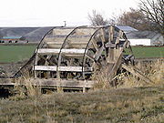
Points of interest
- Tuttle Blacksmith Shop, the oldest building in town
- The Waterwheels located on Southwest First Avenue
- Payette County Fairgrounds
- Roady's Truck Stops Headquarters
- New Plymouth High SchoolNew Plymouth High SchoolNew Plymouth High School is the high school of New Plymouth, Idaho.It was built in 1986 after the previous high school building burned down in a fire on December 18, 1984. Originally, it was designed as a junior-senior high school, housing grades seven through twelve...
- Armoral Tuttle Public Library
- 123 Elm Street