

New Lucena, Iloilo
Encyclopedia
Philippines
The Philippines , officially known as the Republic of the Philippines , is a country in Southeast Asia in the western Pacific Ocean. To its north across the Luzon Strait lies Taiwan. West across the South China Sea sits Vietnam...
. According to the 2000 census, it has a population of 19,490 people in 3,744 households. The "New" in the name was added in 1955.
Barangays
New Lucena is politically subdivided into 21 barangayBarangay
A barangay is the smallest administrative division in the Philippines and is the native Filipino term for a village, district or ward...
s.
|
|
BRIEF HISTORY
Municipality of New Lucena was formerly known as Jimanban, a very small barrio organized sometime in 1800, which was a part of the Municipality of Cabatuan. In 1886 the boundary line separating the jurisdiction of Sta. Barbara and Cabatuan was defined and Jimanban was made part of Sta. Barbara. Intermerriage among the people increased the area's population
Led by Bartolome Valenzuela, a prominent resident of the barrio (Jimanban) the resident organized themselves and petioned the governor general that they be granted independence by putting up a church, convent and a casa real (municipal building). With the help of the provincial officials and captain municipal of the municipalities of Sta. Barbara, Cabatuan and Pototan, Lucena was separated from Sta. Barbara on October 9, 1877 in accordance with the Dirrecion General De Administration Civil. The first Municipal Officials were elected and the first captain municipal was Bartolome Valenzuela known as Tan Abe, the grandfather of the late Senator Tomas Confessor and Representative Patricio Confessor.
It is not recorded when Jimanban was changed to New Lucena but Lucena reportedly comes from dialect Lu (Ulo) which means "head"and "cena" which is the short version for the flower azucena, which means pure and peaceful. Thus, Lucena means pure and peaceful leader.
Another belief was that, Jimanban was changed to Lucena after the name of the Provincial Alcalde Mayor Pedro Gonzales Lucena, the 36th Executive of the Province of Iloilo in 1716-1717.
When the Americans came, Pueblo de lucena was again in incorporated to the Municipal of Sta. Barbara in 1902 for economic security and facilitation of government. In 1921, the prominent cicitizens of Lucena petioned for its separation from Sta. Barbara. On January 1, 1947, Lucena became a new town in the Province of Iloilo, thus it is now called New Lucena.
PHYSICAL CHARACTERISTICS
GEOGRAPHIC LOCATION
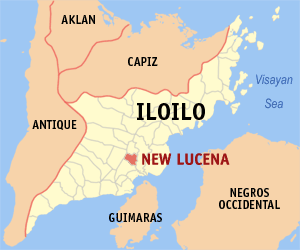
The Municipality of New Lucena is strategically located on coordinates (10¢ª50¡¯00 to 10¢ª54¡¯30¡± ) latitude, (122¢ª32¡¯00¡¯ to 122¢ª 37¡¯00¡±) longitude and the central portion of the Province of Iloilo. It is approximately twenty eight (28) kilometers away from the heart of the city. It is bounded on the northeast by the Municipality of Pototan, on the southeast by the Municipality of Zarraga, on the southwest by the Municipality of Sta. Barbara and on the northwest by the Municipality of Cabatuan and a little portion of Mina.
The town proper of New Lucena could be traversed by land either way via Dawis-Zarraga or via Sta. Barbara. It is 9.8 kilometers away from Sta. Barbara, 15 kilometers away from Cabatuan, 6 kilometers away from Pototan, 6.6 kilometers away from Zarraga and 11 kilometers away from Mina. New Lucena is crisscrossed by the roads from the north to south and east to west thus providing roads for easy means of transportation.
POLITICAL SUBDIVISION AND LAND AREA
New Lucena is composed of the following twenty one (21) barangays, namely: Baclayan, Balabag, Badiang, Bilidan, Bita-og Gaja, Bololacao, Burot, Cabilauan, Cabugao, Cagban, Calumbuyan, Damires, Dawis, General Delgado, Guinobatan, Janipa-an Oeste, Jelicuon Este, Jelicuon Oeste, Pasil and Wari-wari. Barangay Bololacao and Barangay Baclayan are potential growth centers of the municipality.
New Lucena has a total land area of 4412 hectares or 44.12 square kilometers. It is 0.83% of the total area of Iloilo Province.
CLIMATE AND RAINFALL
New Lucena partly belongs to the first district climate region in the province that is the region dry from December to June and wet from July to November. The average monthly rainfall for 1984 is 263.48 cu.m. and an average humidity of 79.83%
SOIL
The soil classification map of New Lucena reflects two types of soil, namely the Alimodian Clay Loam and the Sta. Rita Clay Loam.
The Alimodian Clay Loam is found in barangay Janipa-an Oeste and Badiang, also occupying the larger portion of barangay Jelicuon Oeste, Cabugao, Wari-wari, Cabilauan and Guinobatan; then in the small portion of Barangay Bololacao, Bilidan and Bita-og Gaja
The Sta. Rita Clay Loam covers the Barangay Cagban, Burot, General Delgado, Baclayan, Poblacion, Dawis, Balabag, Damires, Calumbuyan, Jelicuon Este and Pasil; also occupying a the larger parts of Bita-og gaja, Bilidan and Bololacao; then occupying a smaller portion of Barangay Wari-wari, Cabugao and Guinobatan.
Its corresponding type, areas coverage and percentage from the total land area are as follows: The Alimodian Clay Loam covers an area of 1525 hectares is 34.56% of the total land area. The Sta. Rita Clay Loam covers an area of 2887 and 65.44% of the total land area.
SLOPE
The degree of inclination of the municipality ranges from 0 to 15%. It is best described as broad to level land so moderately undulating and gently rolling land sloping in more than one direction.
The slope category A with 0-3% best described as broad to level nearly level, has a total land coverage area of 1475 hectares representing 33.43% of the total land area; 3-5 percent slope or slope category B covers an area of 1762 hectares or 39.94% of the total land area.
The 5-8% slope or category C has a total area coverage of 1050 hectares or 23.80% of the total land area. And the 8-15% slope representing the smallest figure of 125 hectares is 2.83% of the total land area.