

Nevada State Route 374
Encyclopedia
State Route 374 is a state highway
in Nye County
, Nevada
, United States
. It serves as Nevada's gateway to Death Valley National Park
, connecting the park to Beatty
. The highway was known as State Route 58 prior to 1976.
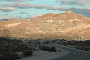 SR 374 begins at the boundary to the Nevada portion of Death Valley National Park in Nye County. From there, it runs due northeast across the open desert. The route curves eastward as it passes through the mountains southwest of Beatty. The road becomes Main Street as it enters the town's southern limits. The route ends at US 95, where Main Street intersects Second Street. The route terminates in the northwest regions of the Amargosa Desert
, and Amargosa Valley
.
 The highway first appeared on Nevada state highway maps as State Route 58 in 1937.
In the 1976 renumbering of Nevada's state highways, the route was reassigned to SR 374. The number change was first seen on state maps in 1978.
State highway
State highway, state road or state route can refer to one of three related concepts, two of them related to a state or provincial government in a country that is divided into states or provinces :#A...
in Nye County
Nye County, Nevada
-National protected areas:* Ash Meadows National Wildlife Refuge* Death Valley National Park * Humboldt-Toiyabe National Forest * Spring Mountains National Recreation Area -Demographics:...
, Nevada
Nevada
Nevada is a state in the western, mountain west, and southwestern regions of the United States. With an area of and a population of about 2.7 million, it is the 7th-largest and 35th-most populous state. Over two-thirds of Nevada's people live in the Las Vegas metropolitan area, which contains its...
, United States
United States
The United States of America is a federal constitutional republic comprising fifty states and a federal district...
. It serves as Nevada's gateway to Death Valley National Park
Death Valley National Park
Death Valley National Park is a national park in the U.S. states of California and Nevada located east of the Sierra Nevada in the arid Great Basin of the United States. The park protects the northwest corner of the Mojave Desert and contains a diverse desert environment of salt-flats, sand dunes,...
, connecting the park to Beatty
Beatty, Nevada
Beatty is a census-designated place along the Amargosa River in Nye County in the U.S. state of Nevada. U.S. Route 95 runs through the CDP, which lies between Tonopah, about to the north, and Las Vegas, about to the southeast. State Route 374 connects Beatty to Death Valley National Park, about ...
. The highway was known as State Route 58 prior to 1976.
Route description
Amargosa Desert
The Amargosa Desert is located in Nye County in western Nevada, United States, along the California–Nevada border. It is largely coincident with the geographic Amargosa Valley....
, and Amargosa Valley
Amargosa Valley
The Amargosa Valley is a Nevada landform east of the Amargosa Range that is the eponym for the town of Amargosa Valley, Nevada. The Tonopah and Tidewater Railroad ran through the valley from 1906 to 1940.-Solar thermal plant:...
.
History
In the 1976 renumbering of Nevada's state highways, the route was reassigned to SR 374. The number change was first seen on state maps in 1978.