
Neerabup, Western Australia
Encyclopedia
Neerabup is a rural locality in Perth
, the capital of Western Australia
. Its Local Government Area
is the City of Wanneroo.
Aboriginal
people had lived in the area for more than 40,000 years, taking advantage of the abundant food and water around the chain of wetlands on the coastal plain. In winter, they moved eastwards away from coastal weather, to return in summer as inland supplies dried up. The Mooro people (led by elder Yellagonga during the early years of European settlement) stretched from the Moore River near Guilderton
to what is now the Perth central business district
, and used to move between Lakes Joondalup, Neerabup and Yanchep.
In 1865, European settlers established the Aboriginal tracks as a stock route from Dongara
(near Geraldton) to Fremantle
, travelling along the west side of the lakes. Lake Neerabup was first recorded by surveyor J. Cowle in 1867, the name being a Noongar word which possibly means "swampy place" or "small basin". The part of the stock route between Joondalup and Yanchep is now part of the Yaberoo Budjara Heritage Trail, part of the Bicentennial Heritage Trails Network established in 1988.
The area was often spelled Neerabub, especially by postal and telecommunications authorities, until as recently as the 1960s. It was approved as a suburb name in 1982.
to the west, Pinjar Road
to the east and Flynn Drive and Burns Beach Road to the south.
Neerabup's population was not measured at the ABS
2001 census.
. The area also contains a golf course, small wineries, a small industrial area on Flynn Drive and several sand and limestone quarries. Barbagallo Raceway
and Wanneroo Kartway WA's premier motorsport
facilities, are located in the suburb's northeast.
bus service is the 391 between Joondalup train station and Carramar
2 km to the south. These services are operated by Path Transit
.
historically, although most have been won by the Coalition
in recent times, especially at federal level.
Perth, Western Australia
Perth is the capital and largest city of the Australian state of Western Australia and the fourth most populous city in Australia. The Perth metropolitan area has an estimated population of almost 1,700,000....
, the capital of Western Australia
Western Australia
Western Australia is a state of Australia, occupying the entire western third of the Australian continent. It is bounded by the Indian Ocean to the north and west, the Great Australian Bight and Indian Ocean to the south, the Northern Territory to the north-east and South Australia to the south-east...
. Its Local Government Area
Local Government Areas of Western Australia
The Australian state of Western Australia is divided into 141 local government areas...
is the City of Wanneroo.
History
Prior to European settlement, NoongarNoongar
The Noongar are an indigenous Australian people who live in the south-west corner of Western Australia from Geraldton on the west coast to Esperance on the south coast...
Aboriginal
Indigenous Australians
Indigenous Australians are the original inhabitants of the Australian continent and nearby islands. The Aboriginal Indigenous Australians migrated from the Indian continent around 75,000 to 100,000 years ago....
people had lived in the area for more than 40,000 years, taking advantage of the abundant food and water around the chain of wetlands on the coastal plain. In winter, they moved eastwards away from coastal weather, to return in summer as inland supplies dried up. The Mooro people (led by elder Yellagonga during the early years of European settlement) stretched from the Moore River near Guilderton
Guilderton, Western Australia
Guilderton is a small coastal town north of Perth, Western Australia at the mouth of the Moore River in the Shire of Gingin.It was originally known as Gabbadah, an Aboriginal term meaning "mouthful of water" until its gazetting as a town in 1951...
to what is now the Perth central business district
Central business district
A central business district is the commercial and often geographic heart of a city. In North America this part of a city is commonly referred to as "downtown" or "city center"...
, and used to move between Lakes Joondalup, Neerabup and Yanchep.
In 1865, European settlers established the Aboriginal tracks as a stock route from Dongara
Dongara, Western Australia
Dongara is a town located 351 km north-northwest of Perth on the Brand Highway. The town is located at the mouth of the Irwin River. In recent years the area has been marketed as the 'Rock lobster capital of Australia'....
(near Geraldton) to Fremantle
Fremantle
Freemantle is a suburb of Southampton in England.Fremantle or Freemantle may also refer to:- Places :* Fremantle, the port city to the capital Perth, Western Australia...
, travelling along the west side of the lakes. Lake Neerabup was first recorded by surveyor J. Cowle in 1867, the name being a Noongar word which possibly means "swampy place" or "small basin". The part of the stock route between Joondalup and Yanchep is now part of the Yaberoo Budjara Heritage Trail, part of the Bicentennial Heritage Trails Network established in 1988.
The area was often spelled Neerabub, especially by postal and telecommunications authorities, until as recently as the 1960s. It was approved as a suburb name in 1982.
Geography
Neerabup is bounded by Wattle Avenue to the north, the proposed Mitchell FreewayMitchell Freeway
Mitchell Freeway is a long freeway in Perth, Western Australia, linking Perth's central business district with its outer northern suburbs. It is allocated Route 2 for its entire length and is named after former state Premier and Governor Sir James Mitchell....
to the west, Pinjar Road
Pinjar Road, Perth
Pinjar Road is an important arterial road in Perth, Western Australia. Traversing the East Wanneroo area within the City of Wanneroo, it is a regional road designed for the movement of heavy goods and freight from the state's north and from the Neerabup industrial area...
to the east and Flynn Drive and Burns Beach Road to the south.
Neerabup's population was not measured at the ABS
Australian Bureau of Statistics
The Australian Bureau of Statistics is Australia's national statistical agency. It was created as the Commonwealth Bureau of Census and Statistics on 8 December 1905, when the Census and Statistics Act 1905 was given Royal assent. It had its beginnings in section 51 of the Constitution of Australia...
2001 census.
Facilities
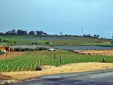
Neerabup is a sparsely populated agricultural suburb. Several plant nurseries, a fruit and vegetable shop at Menchetti Road and the Neerabup Lake wetland are situated along Wanneroo Road. The western strip between Wanneroo Road and the proposed Mitchell Freeway is approximately the southern half of the Neerabup National ParkNeerabup National Park
Neerabup National Park is a national park in the City of Wanneroo in Western Australia, situated approximately north of Perth.The park is found to the west of Wanneroo Road and is a long thin strip of bushland that is about in length...
. The area also contains a golf course, small wineries, a small industrial area on Flynn Drive and several sand and limestone quarries. Barbagallo Raceway
Barbagallo Raceway
Barbagallo Raceway is a motorsport circuit located in Wanneroo, approximately north of Perth in Western Australia.The circuit was originally known as Wanneroo Park and the first race meet took place in March 1969. Initially the major race per year was a 6 hour Le Mans style race for sedans and...
and Wanneroo Kartway WA's premier motorsport
Motorsport
Motorsport or motorsports is the group of sports which primarily involve the use of motorized vehicles, whether for racing or non-racing competition...
facilities, are located in the suburb's northeast.
Transport
Neerabup is not served by public transport at the present time. The nearest TransperthTransperth
Transperth is the brand name of the public transport system in Perth, Western Australia. It is operated by the Public Transport Authority.-History:...
bus service is the 391 between Joondalup train station and Carramar
Carramar, Western Australia
Carramar is a suburb of Perth, Western Australia, located within the City of Wanneroo and it is situated 29 km from the Perth CBD. Its postcode is 6031, and it came into being, together with Tapping to the south, in 1995 as a subdivision of Neerabup....
2 km to the south. These services are operated by Path Transit
Path Transit
Path Transit is a transport company operating 320 buses in Perth, Australia since 1996.It has depots in :* Bayswater* MalagaPath Transit also provides rental of vehicles for private functions.-Vehicles:...
.
Politics
Neerabup's political leanings are unclear due to its small size and the lack of a polling booth. The nearest large booths tend to favour the Australian Labor PartyAustralian Labor Party
The Australian Labor Party is an Australian political party. It has been the governing party of the Commonwealth of Australia since the 2007 federal election. Julia Gillard is the party's federal parliamentary leader and Prime Minister of Australia...
historically, although most have been won by the Coalition
Coalition (Australia)
The Coalition in Australian politics refers to a group of centre-right parties that has existed in the form of a coalition agreement since 1922...
in recent times, especially at federal level.