
Navajo National Monument
Encyclopedia
Navajo National Monument is located within the northwest portion of the Navajo Reservation
in northern Arizona
.
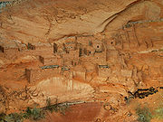
Navajo National Monument preserves three of the most intact cliff dwellings of the ancestral puebloan people (Hisatsinom). The Navajo people who live here today call these ancient ones Anasazi. The monument is high on the Shonto plateau, overlooking the Tsegi Canyon system in the Navajo Nation in northern Arizona. The monument, located west of Kayenta, Arizona
, features a visitor center with a museum, two short self-guided mesa top trails, two small campgrounds, and a picnic area. Rangers guide visitors on free tours of the Keet Seel and Betatakin cliff dwellings. The Inscription House site , further west, is currently closed to public access.
The Sandal Trail is an accessible self-guided walk that provides views of the spectacular canyonlands and rugged topography near the visitor center. Interpretive signs provide information on local flora and other topics. The 1.6 km round-trip trail ends at an overlook of the Betatakin ruins across the 560 feet (170 m) deep Betatakin Canyon. The National Monument was listed on the National Register of Historic Places
on October 15, 1966.
is credited for selecting the term Anasazi, which refers to the ancient people that inhabited this region and means "Enemy Ancestors" in Navajo. It was not until 1909, after Navajo National Monument was created, that John Wetherill and Navajo guide Clatsozen Benully "discovered" Betatakin.
The Weatherill Brothers made a living from giving guided tours of sites in and around the Tsegi Canyon and Utah. Later in their careers, the Weatherill brothers were largely involved in efforts for the preservation and protection of the sites that made up Navajo National Monument.
, with beans and cucurbits also being incorporated into their diet. While the people of the Tsegi Canyon system relied heavily on agriculture for their food, they also hunted wild game that was indigenous to the area.
It is thought that these Anasazi people lived in these cave dwellings to optimize the amount of sustainable land to produce crops. By living in these caves, and not on the mesas or the canyon floors, they were able to use this land towards agricultural production to ensure their success in this high elevation, desert environment. The ruins that make up Navajo National Monument were a large number of rooms used for storage, suggesting that at some point their crop production was successful enough to dedicate a significant amount of their living area towards storage purposes.
 The structures contained within this cave site were constructed mainly of sandstone blocks plastered together with mud and mortar. In marked contrast to earlier constructions and villages on top of the mesas, the cliff dwelling of Navajo National Monument reflected a region-wide trend towards the aggregation of growing regional populations into close, highly defensible quarters during the mid to late 13th century.
While much of the construction in this site remains similar to common ancestral Pueblo architectural forms, including such features as Kivas, a circular tower (at Kiet Siel), and pit-houses, the limited space that this site presented created a much more densely populated living area. At its peak, Kiet Siel had more than 150 rooms and 6 kivas, while Betatakin had about 120 rooms and only one kiva.
Jacal
walls were also found to be used at this site. Jacal walls were made from a screen of upright wooden poles plastered together with mud. The dry conditions and protection from the elements at Kiet Siel allowed for some of the most notable preservation of these architectural characteristics in all of the Southwest.
There were also a number of structures believed to be built at the base of the cliff as well. But due to this area not being protected by the over-hanging cliff wall, its exposure to the elements led to its destruction by erosion. At Kiet Siel, archaeological excavations have revealed that there were 25 room clusters beneath the overhanging wall, each that included 1 common living room, with anywhere from 1 to 4 storage rooms surrounding a small courtyard. The layout of these dwellings greatly mirrored that of the Pueblo III
structures at Mesa Verde, whereas Betatakin had about 20 room clusters.
There is evidence later in the record to suggest the beginning of an episode of deep arroyo cutting, that would have damaged what was left of the usable agricultural land. Increased deposition of sediment onto agricultural lands caused the lowering of the water table, thus making the land inadequate for farming. Regardless of their reasoning, near the end of the thirteenth century its evident that the Anasazi people migrated towards places with more stable and abundant water sources, suggesting that the agricultural land in this area had become unsuitable to sustain the population levels that once inhabited this spectacular cave site.
Hopi
legends tell a different tale. According to oral tradition, the area known as Wunuqa (modern day Tsegi Canyon) was abandoned as part of a spiritual quest. In particular, the Snake Clan inhabited the Navajo National Monument ruins, along with the Horn Clan. The Horn Clan forced the Snake Clan out, due to the children of the Snake Clan biting other children and causing death. This may be an allegory for some historical occurrence, in which one group forced another out for a perceived fault or slight.
Navajo Nation
The Navajo Nation is a semi-autonomous Native American-governed territory covering , occupying all of northeastern Arizona, the southeastern portion of Utah, and northwestern New Mexico...
in northern Arizona
Arizona
Arizona ; is a state located in the southwestern region of the United States. It is also part of the western United States and the mountain west. The capital and largest city is Phoenix...
.
Navajo National Monument preserves three of the most intact cliff dwellings of the ancestral puebloan people (Hisatsinom). The Navajo people who live here today call these ancient ones Anasazi. The monument is high on the Shonto plateau, overlooking the Tsegi Canyon system in the Navajo Nation in northern Arizona. The monument, located west of Kayenta, Arizona
Kayenta, Arizona
Kayenta is a census-designated place which is part of the Navajo Nation and is in Navajo County, Arizona, United States. The population was 5,189 at the 2010 census. Kayenta is located south of Monument Valley and contains a number of hotels and motels which service visitors to Monument...
, features a visitor center with a museum, two short self-guided mesa top trails, two small campgrounds, and a picnic area. Rangers guide visitors on free tours of the Keet Seel and Betatakin cliff dwellings. The Inscription House site , further west, is currently closed to public access.
The Sandal Trail is an accessible self-guided walk that provides views of the spectacular canyonlands and rugged topography near the visitor center. Interpretive signs provide information on local flora and other topics. The 1.6 km round-trip trail ends at an overlook of the Betatakin ruins across the 560 feet (170 m) deep Betatakin Canyon. The National Monument was listed on the National Register of Historic Places
National Register of Historic Places
The National Register of Historic Places is the United States government's official list of districts, sites, buildings, structures, and objects deemed worthy of preservation...
on October 15, 1966.
Kiet Siel
Kiet Siel , which stands for "broken house" in Navajo, is a well preserved cliff dwelling of the ancient Anasazi people located in a branch of the Tsegi Canyon in the Kayenta region of Northeastern Arizona. The site was first occupied at around AD 1250, during a time in which a large number of people were believed to be aggregating in sites such as this in this part of the American Southwest. There was a construction boom at Kiet Siel between AD 1272 and 1275, with construction then slowly tapering off and halting completely at AD 1286. Once construction halted in AD 1286, there was no evidence of structures being built until its subsequent abandonment some 20 years later. At its peak, its believed that up to 150 people inhabited this site at one time. Kiet Siel, along with Betatakin and (Inscription House), are the three cliff dwelling sites that make up the now protected Navajo National Monument. These three sites were declared a national monument in 1909. Due to the extremely dry climate and natural overhanging cliff, the conditions at Kiet Siel were quite optimal for excellent preservation of the site's dwellings and artifacts. Kiet Siel is considered by many archaeological experts to be one of the best preserved larger ruins in the American Southwest.Betatakin
Betatakin means "House Built on a Ledge" in Navajo. In Hopi, the name of the place is Talastima, or "Place of the Corn Tassel". Betatakin is smaller than nearby Kiet Siel, with about 120 rooms at the time of abandonment. However, like Keet Seel, Betatakin was constructed of sandstone, mud mortar, and wood. Today only about 80 rooms remain, due to rock falls inside the alcove. Betatakin only has one kiva, whereas Kiet Siel has several. Betatakin was built in an enormous alcove measuring 452 feet high and 370 feet across between 1267 and 1286 The first excavations occurred in 1917 under Neil Judd, and continued into the 1950s and 1960s under archaeologists like Jeffery Dean. During its two-decade heyday Dean estimated a maximum population of about 125 people.Discovery
The site of Kiet Siel was "discovered" in 1895 by the Wetherill Brothers. Originally part of a ranching family from Colorado, the Wetherill's keen interest in the Ancient Anasazi led them to pursue numerous expeditions into the heart of the Kayenta region, largely uncovering a number of sites that had remained undiscovered until then. Richard WetherillRichard Wetherill
Richard Wetherill , a member of a prominent Colorado ranching family, was an amateur explorer in the discovery, research and excavation of sites associated with the Ancient Pueblo People...
is credited for selecting the term Anasazi, which refers to the ancient people that inhabited this region and means "Enemy Ancestors" in Navajo. It was not until 1909, after Navajo National Monument was created, that John Wetherill and Navajo guide Clatsozen Benully "discovered" Betatakin.
The Weatherill Brothers made a living from giving guided tours of sites in and around the Tsegi Canyon and Utah. Later in their careers, the Weatherill brothers were largely involved in efforts for the preservation and protection of the sites that made up Navajo National Monument.
Subsistence
The Anasazi of this area were a sedentary group that largely based their subsistence on agriculture. Their primary crop at the sites within Navajo National Monument was maizeMaize
Maize known in many English-speaking countries as corn or mielie/mealie, is a grain domesticated by indigenous peoples in Mesoamerica in prehistoric times. The leafy stalk produces ears which contain seeds called kernels. Though technically a grain, maize kernels are used in cooking as a vegetable...
, with beans and cucurbits also being incorporated into their diet. While the people of the Tsegi Canyon system relied heavily on agriculture for their food, they also hunted wild game that was indigenous to the area.
It is thought that these Anasazi people lived in these cave dwellings to optimize the amount of sustainable land to produce crops. By living in these caves, and not on the mesas or the canyon floors, they were able to use this land towards agricultural production to ensure their success in this high elevation, desert environment. The ruins that make up Navajo National Monument were a large number of rooms used for storage, suggesting that at some point their crop production was successful enough to dedicate a significant amount of their living area towards storage purposes.
Dwellings/ Architecture
While much of the construction in this site remains similar to common ancestral Pueblo architectural forms, including such features as Kivas, a circular tower (at Kiet Siel), and pit-houses, the limited space that this site presented created a much more densely populated living area. At its peak, Kiet Siel had more than 150 rooms and 6 kivas, while Betatakin had about 120 rooms and only one kiva.
Jacal
Jacal
The jacal is an adobe style housing structure historically found throughout parts of the south-western United States and Mexico. The structure was employed by some Native people of the Americas prior to European colonization and was later employed by both Hispanic and Anglo settlers in Texas and...
walls were also found to be used at this site. Jacal walls were made from a screen of upright wooden poles plastered together with mud. The dry conditions and protection from the elements at Kiet Siel allowed for some of the most notable preservation of these architectural characteristics in all of the Southwest.
There were also a number of structures believed to be built at the base of the cliff as well. But due to this area not being protected by the over-hanging cliff wall, its exposure to the elements led to its destruction by erosion. At Kiet Siel, archaeological excavations have revealed that there were 25 room clusters beneath the overhanging wall, each that included 1 common living room, with anywhere from 1 to 4 storage rooms surrounding a small courtyard. The layout of these dwellings greatly mirrored that of the Pueblo III
Pueblo III Era
The Pueblo III Era, AD 1150 to 1350, was the third period, also called the "Great Pueblo period" when Ancient Pueblo People lived in large cliff-dwelling, multi-storied pueblo, or cliff-side talus house communities...
structures at Mesa Verde, whereas Betatakin had about 20 room clusters.
Abandonment
Although many archaeologists agree that there is a definitive and sharp exodus from this region in the Southwest, there has been considerable debate on the determining factors that forced people to migrate out of this area. Archaeologists have determined that there was a distinct decrease in the amount of annual precipitation between AD 1276 and 1299, a period of time that is now referred to as the "Great Drought". With the limited amount of rainfall in an already arid environment, there is no doubt that there was a considerable amount of increased stress put on the agricultural systems that these people depended on.There is evidence later in the record to suggest the beginning of an episode of deep arroyo cutting, that would have damaged what was left of the usable agricultural land. Increased deposition of sediment onto agricultural lands caused the lowering of the water table, thus making the land inadequate for farming. Regardless of their reasoning, near the end of the thirteenth century its evident that the Anasazi people migrated towards places with more stable and abundant water sources, suggesting that the agricultural land in this area had become unsuitable to sustain the population levels that once inhabited this spectacular cave site.
Hopi
Hopi
The Hopi are a federally recognized tribe of indigenous Native American people, who primarily live on the Hopi Reservation in northeastern Arizona. The Hopi area according to the 2000 census has a population of 6,946 people. Their Hopi language is one of the 30 of the Uto-Aztecan language...
legends tell a different tale. According to oral tradition, the area known as Wunuqa (modern day Tsegi Canyon) was abandoned as part of a spiritual quest. In particular, the Snake Clan inhabited the Navajo National Monument ruins, along with the Horn Clan. The Horn Clan forced the Snake Clan out, due to the children of the Snake Clan biting other children and causing death. This may be an allegory for some historical occurrence, in which one group forced another out for a perceived fault or slight.
See also
- Canyon de Chelly National MonumentCanyon de Chelly National MonumentCanyon de Chelly National Monument was established on April 1, 1931 as a unit of the National Park Service. It is located in northeastern Arizona within the boundaries of the Navajo Nation...
- Mesa Verde National ParkMesa Verde National ParkMesa Verde National Park is a U.S. National Park and UNESCO World Heritage Site located in Montezuma County, Colorado, United States. It was created in 1906 to protect some of the best-preserved cliff dwellings in the world...
- Oasisamerica culturesOasisamericaOasisamerica was a broad cultural area in pre-Columbian southwestern North America. It extended from modern-day Utah down to southern Chihuahua, and from the coast on the Gulf of California eastward to the Río Bravo river valley...
Related Readings
- Doyel, David E. & Dean, Jeffrey S. "Environmental Change and Human Adaptation in the Ancient American Southwest". The University of Utah Press, Salt Lake City. 1996
- Ferguson W.M. & Rohn A.H. "Anasazi Ruins of the Southwest in Color". The University of New Mexico Press, Albuquerque. 1999
- Noble, David Grant. "Houses Beneath the Rock: The Anasazi of Canyon de Chelly and Navajo National Monument". Ancient City Press, Sante Fe, New Mexico. 1986
- Plog, Stephen. "Ancient Peoples of the American Southwest". Thames & Hudson Inc., 500 Fifth Avenue, New York, New York 10110. 1997
- Rothman, Hal. "Navajo National Monument: A Place and Its People". Southwest Cultural Resources Center. Santa Fe, New Mexico. Professional Papers No. 40, 1991
External links
- Official NPS website: Navajo National Monument
- Betatakin Photo Gallery
- American Southwest, a National Park Service Discover Our Shared Heritage Travel Itinerary
- NPS website on Navajo National Monument, http://www.nps.gov/nava/historyculture/index.htm