

National Register of Historic Places listings in Wake County, North Carolina
Encyclopedia
National Register of Historic Places
The National Register of Historic Places is the United States government's official list of districts, sites, buildings, structures, and objects deemed worthy of preservation...
in Wake County, North Carolina
Wake County, North Carolina
Wake County is a county located in the U.S. state of North Carolina. As of the 2010 census, the population was 900,993 making it North Carolina's second most populated county...
. Click the "Map of all coordinates" link to the right to view a Google map of all properties and districts with latitude and longitude coordinates in the table below.
| Landmark name | Image | Date listed | Location | City or Town | Summary | |
|---|---|---|---|---|---|---|
| 1 | Adams-Edwards House | 5400 Tryon Rd. 35°44′54"N 78°43′53"W |
Raleigh | |||
| 2 | Agriculture Building Agriculture Building The Agriculture Building is a state government building located in Raleigh, North Carolina. Built in 1921, it is an example of Classical Revival architecture.The Agriculture Building was listed on the National Register of Historic Places in 1976.-See also:... |
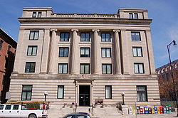 |
E. Edenton St. 35°46′53"N 78°38′22"W |
Raleigh | ||
| 3 | Andrews-Duncan House | 407 N. Blount St. 35°47′4.66"N 78°38′10.55"W |
Raleigh | |||
| 4 | Apex City Hall | N. Salem St. 35°43′57"N 78°51′3"W |
Apex | |||
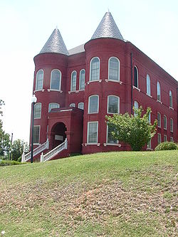
| 5 | Apex Historic District Apex Historic District The Apex Historic District is the historic commercial and residential center of Apex, North Carolina, a satellite town of the state capital Raleigh. The district revolves around Salem Street, the main thoroughfare in downtown Apex. In 2007, CNNMoney.com ranked Apex as the 14th best place to live in... |
 |
Roughly bounded by N. Elm, N. Salem, Center, S. Salem, and W. Chatham Sts.; also roughly bounded by E. Chatham, S. Hughes, S. Mason, and E. Moore Sts.; also Grove and Thompson Sts., and parts of Hunter St.; also roughly centered on Hunter, Center, Chatham, Cunningham, Holleman, and Hughes Sts. 35°43′53"N 78°51′5"W |
Apex | Second, third, and fourth set of boundaries represent boundary increases of , , and respectively | |
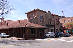
| 6 | Apex Union Depot Apex Union Depot The Apex Union Depot is a historic railroad station located on Salem Street in downtown Apex, North Carolina and is the centerpiece of the Apex Historic District... |
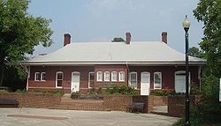 |
SE corner N. Salem St. and Center St. 35°43′55"N 78°51′1"W |
Apex | ||
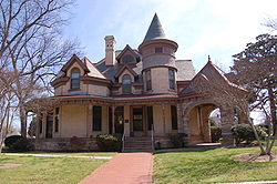
| 7 | Dr. Thomas H. Avera House Dr. Thomas H. Avera House The Dr. Thomas H. Avera House is a historic home in Wendell, North Carolina, a town in eastern Wake County. Built in 1874, the house is an example of Gothic and Italianate architecture. In September 2003, the Dr. Thomas H. Avera House was listed on the National Register of Historic Places.... |
6600 Robertson Pond Rd. 35°49′7"N 78°24′11"W |
Wendell | |||
| 8 | Bailey-Estes House | 9020 Mangum Dairy Rd. 36°2′8"N 78°36′9"W |
Wake Forest | Wake County MPS | ||
| 9 | George and Neva Barbee House George and Neva Barbee House The George and Neva Barbee House is a historic American Craftsman Bungalow style home located in Zebulon, North Carolina, a town near of Raleigh.The house was built in 1914 and listed on the National Register of Historic Places in August 2007.... |
216 W. Gannon Ave. 35°49′30"N 78°19′5"W |
Zebulon | |||
| 10 | Battery Heights Historic District Battery Heights Historic District The Battery Heights Historic District is a historic neighborhood southeast of downtown Raleigh, North Carolina. Named for the earthen batteries stationed in the area during the Civil War, the neighborhood has a surburban character, despite its close proximity to the city center.The district is... |
Bounded roughly by East Martin St. on the north, Battery Dr. on the east, East Davie St. on the south, and Sherrybrook Dr. on the west 35°46′31"N 78°36′54"W |
Raleigh | Post-World War II and Modern Architecture in Raleigh, North Carolina, 1945-1965 MPS | ||
| 11 | Beaver Dam | SR 2049 at SR 2233 35°48′45"N 78°29′6"W |
Knightdale | |||
| 12 | Ben-Wiley Hotel | 331 S. Main St. 35°34′51"N 78°47′59"W |
Fuquay-Varina | |||
| 13 | Dr. Nathan M. Blalock House | 6741 Rock Service Station Rd. 35°35′42"N 78°38′49"W |
Raleigh | |||
| 14 | Bloomsbury Historic District Bloomsbury Historic District The Bloomsbury Historic District is a neighborhood near downtown Raleigh, North Carolina. Located north of the Five Points intersection, the boundaries include Fairview Road, St. Mary's Street, Byrd Street, Sunset Drive, and Whitaker Mill Road. In May 2002, Bloomsbury was listed on the National... |
Roughly bounded by Fairview Rd., St. Mary's St., Byrd St., Sunset Dr. and Whitaker Mill Rd. 35°48′38"N 78°38′53"W |
Raleigh | |||
| 15 | Boylan Apartments | 817 Hillsborough St. 35°46′57"N 78°39′5"W |
Raleigh | |||
| 16 | Boylan Heights Boylan Heights (Raleigh, North Carolina) Boylan Heights is a historic neighborhood in Raleigh, North Carolina. It was added to the National Register of Historic Places as a historic district on July 29, 1985... |
Roughly bounded by the Norfolk Southern railroad line, Mountford, Martin and Florence Sts. and Dorothea Dr. 35°46′26"N 78°39′7"W |
Raleigh | |||
| 17 | Briggs Hardware Building Briggs Hardware Building The Briggs Hardware Building is a four story historic building in downtown Raleigh, North Carolina built in 1874 by Thomas Briggs to house his family-owned hardware store... |
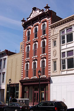 |
220 Fayetteville St. 35°46′39"N 78°38′23"W |
Raleigh | ||
| 18 | Bennett Bunn Plantation Bennett Bunn Plantation The Bennett Bunn Plantation is a historic farm near Zebulon, North Carolina, a suburb of Raleigh. The plantation, located beside US 264 in eastern Wake County, consists of a two-story house built in 1833, barns, and of farmland and forests... |
NC 97 35°50′14"N 78°16′59"W |
Zebulon | |||
| 19 | Cameron Park | Roughly bounded by Clark Ave., W. Peace and Saint Mary's Sts., College Pl., Hillsborough St. and Oberlin Rd. 35°47′7"N 78°39′29"W |
Raleigh | |||
| 20 | Cannady-Brogden Farm Cannady-Brogden Farm The Cannady-Brogden Farm is a historic home and farm located in Creedmoor, North Carolina. Built in 1904, the house is an example of a Queen Anne triple-A-roofed I-shaped building... |
15260 Brogden Rd. 36°3′54.51"N 78°41′8.89"W |
Creedmoor | |||
| 21 | Capehart House Capehart House The Capehart House is a Queen Anne Style House built circa 1898 by Charles P. Snuggs for Lucy Catherine Capehart and her second husband B.A. Capehart. It is on the National Register-Raleigh Historic Property. It is located on 424 North Blount Street. The house is one of the best examples of... |
 |
N. Blount St. 35°56′28"N 78°34′3"W |
Raleigh | ||
| 22 | Capital Club Building | 16 W. Martin St. 35°46′38"N 78°38′26"W |
Raleigh | |||
| 23 | Capitol Area Historic District Capitol Area Historic District The Capitol Area Historic District in Raleigh, North Carolina is a historic district listed in 1978 on the National Register of Historic Places. It may include the following separately listed buildings:*North Carolina State Capitol,... |
State Capitol building and environs 35°46′48"N 78°38′15"W |
Raleigh | |||
| 24 | Capitol Heights Historic District | Roughly bounded by Penn Rd., North State St., Glascock St., and Madison Rd. 35°47′26"N 78°37′18"W |
Raleigh | Post-World War II and Modern Architecture in Raleigh, North Carolina, 1945-1965 MPS | ||
| 25 | Caraleigh Mills | 421 Maywood Ave. 35°45′41"N 78°39′12"W |
Raleigh | |||
| 26 | Carolina Coach Garage and Shop | 510 E. Davie St. 35°46′31.24"N 78°37′53.66"W |
Raleigh | |||
| 27 | Carolina Power and Light Company Car Barn and Automobile Garage | 116 N. West St. 35°46′56"N 78°38′44"W |
Raleigh | |||
| 28 | Carpenter Historic District | Along Capenter-Morrisville Road, east of CSX Transportation tracks and west of Davis Drive 35°49′18"N 78°51′47"W |
Cary | |||
| 29 | Cary Historic District | Roughly along Dry Ave., S. Academy St., and Park St. 35°47′9"N 78°46′56"W |
Cary | |||
| 30 | Christ Church | 120 E. Edenton St. 35°46′59"N 78°38′17"W |
Raleigh | |||
| 31 | Christ Episcopal Church Christ Episcopal Church (Raleigh, North Carolina) Christ Episcopal Church is an Episcopal church in Raleigh, North Carolina located on Edenton Street.It is located within Capitol Area Historic District, a National Historic Landmark district and has a distinctive bronze weather vane at the peak of its steeple... |
120 E. Edenton St. 35°46′52"N 78°39′36"W |
Raleigh | |||
| 32 | City Cemetery City Cemetery (Raleigh, North Carolina) The City Cemetery of Raleigh, also known as Old City Cemetery, was authorized in 1798 by the North Carolina General Assembly as Raleigh's first burying ground. It was laid out on of land just outside the original 1792 eastern boundary of Raleigh and bounded by East Street on the west, East... |
17 S. E. St. 35°46′44.65"N 78°37′51.42"W |
Raleigh | |||
| 33 | Crabtree Creek Recreational Demonstration Area | Roughly bounded by Interstate 40 Interstate 40 Interstate 40 is the third-longest major east–west Interstate Highway in the United States, after I-90 and I-80. Its western end is at Interstate 15 in Barstow, California; its eastern end is at a concurrency of U.S. Route 117 and North Carolina Highway 132 in Wilmington, North Carolina... , U.S. Route 70 U.S. Route 70 U.S. Route 70 is an east–west United States highway that runs for 2,385 miles from eastern North Carolina to east-central Arizona. As can be derived from its number, it is a major east–west highway of the Southern and Southwestern United States... , and the Raleigh-Durham Airport 35°51′17"N 78°45′9"W |
Raleigh | |||
| 34 | William A. Curtis House | 1415 Poole Rd. 35°46′43.58"N 78°37′0.51"W |
Raleigh | |||
| 35 | Josephus Daniels House Josephus Daniels House Josephus Daniels House, also known as Wakestone or Masonic Temple of Raleigh, was the home of Josephus Daniels, who was Secretary of the Navy under President Woodrow Wilson.It was declared a National Historic Landmark in 1976.... |
1520 Caswell St. 35°47′57"N 78°38′50"W |
Raleigh | |||
| 36 | Davis-Adcock Store Davis-Adcock Store The Davis-Adcock Store is a historic commercial building in Wilbon, North Carolina, a crossroads north of Fuquay-Varina. The building was constructed in 1906 and listed on the National Register of Historic Places in September 2006.... |
2013 Piney Grove-Wilbon Rd., on the eastern side of Piney Grove-Wilbon Rd., and 0.2 miles north of its junction with Wilbon Rd. 35°36′11"N 78°50′21"W |
Wilbon | |||
| 37 | Depot Historic District | 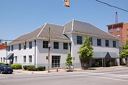 |
Bounded by W. Hargett, S. McDowell, S. Dawson, and W. Cabarrus St. 35°46′42"N 78°38′38"W |
Raleigh | ||
| 38 | Dix Hill Dix Hill Dix Hill is the informal name for a high, rolling expanse of land in Raleigh, North Carolina.The Dorothea Dix Hospital, a historic institution caring for the mentally ill, is located on the site.Dix Hill is referred to in David Sedaris's novel Naked... |
Roughly bounded by Dorothea Dr., Lake Wheeler Rd. and the Norfolk Southern RR tracks 35°46′6"N 78°39′15"W |
Raleigh | |||
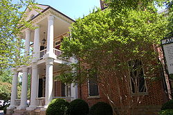
| 39 | Dodd-Hinsdale House Dodd-Hinsdale House The Dodd-Hinsdale House was built in 1879 at 330 Hillsborough Street for Raleigh Mayor William H. Dodd. It is a brick house with, bracketed eaves, narrow segmented arch windows, porches, and carved millwork which are all characteristic of the Italianate style... |
330 Hillsborough St. 35°46′47"N 78°38′27"W |
Raleigh | |||
| 40 | Downtown Garner Historic District | Roughly Garner Rd. and Main St. from New Rand Rd. to Broughton St. 35°42′27"N 78°36′25"W |
Garner | |||
| 41 | Downtown Wake Forest Historic District | South White St. roughly from E. Roosevelt Ave. to Owen Ave. 35°58′48"N 78°30′36"W |
Wake Forest | |||
| 42 | W. E. B. DuBois School | 536 Franklin St. 35°59′6"N 78°30′4"W |
Wake Forest | |||
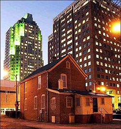
| 43 | East Raleigh-South Park Historic District East Raleigh-South Park Historic District The East Raleigh-South Park Historic District is the largest African-American neighborhood in Raleigh, North Carolina. The district, located south and east of downtown Raleigh, covers approximately 30 blocks and contains portions of the Smith-Haywood and St. Petersburg neighborhoods... |
 |
Roughly bounded by Bragg, East, E. Lenoir, Alston, Camden, Hargett, Swain, Davis, and S. Blount Sts. 35°46′20"N 78°38′0"W |
Raleigh | ||
| 44 | Edenwood | 7620 Old Stage Rd. 35°40′26"N 78°39′38"W |
Garner | |||
| 45 | Elmwood | 16 N. Boylan Ave. 35°46′53"N 78°38′56"W |
Raleigh | |||
| 46 | Estey Hall Estey Hall Estey Hall is a historic building on the campus of Shaw University in Raleigh, North Carolina. It was the first building constructed for the higher education of African-American women in the United States... |
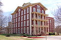 |
E. South St. on Shaw University campus 35°46′17"N 78°38′14"W |
Raleigh | ||
| 47 | Fadum House | 3056 Granville Dr. 35°49′19"N 78°39′51"W |
Raleigh | |||
| 48 | Falls of the Neuse Manufacturing Company | Neuse River at SR 2000 35°56′20"N 78°34′44"W |
Falls | |||
| 49 | Fayetteville Street Historic District Fayetteville Street Historic District The Fayetteville Street Historic District in Raleigh, North Carolina is a historic district listed on the National Register of Historic Places... |
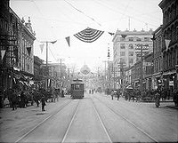 |
Roughly 100-400 blks. of Fayetteville, 00-100 blks. of W. Hargett, 00 blk. of W. Martin, 100-400 S. Salisbury Sts. 35°46′38.95"N 78°38′21.34"W |
Raleigh | ||
| 50 | Federal Building Federal Building (Raleigh, North Carolina) The Federal Building, also known as the Century Post Office, is a historic building located on Fayetteville Street in Raleigh, North Carolina. It was the first Federal Government project in the South following the Civil War. Construction of the building began in 1874 and was completed in 1878. The... |
 |
300 Fayetteville St. 35°46′38"N 78°38′40"W |
Raleigh | ||
| 51 | Forestville Baptist Church Forestville Baptist Church Forestville Baptist Church is a historic church located in Wake Forest, North Carolina, a satellite town of the state capital Raleigh. Constructed in 1860, the church building is a combination of Greek Revival and Italianate architecture. In October 1984, Forestville Baptist Church was listed on... |
U.S. 1-A 35°57′36"N 78°31′13"W |
Forestville | |||
| 52 | Free Church of the Good Shepherd | 110 S. E. St. 35°57′36"N 78°31′13"W |
Raleigh | |||
| 53 | Fuquay Mineral Spring | NE corner of Main and W. Spring Sts. 35°34′48"N 78°48′3"W |
Fuquay-Varina | |||
| 54 | Fuquay Springs High School | 112 N. Ennis St. 35°35′12"N 78°47′38"W |
Fuquay-Varina | |||
| 55 | Fuquay Springs Historic District | Roughly, S. Main St. and Fuquay Ave. from Spring St. to Sunset Dr. and Spring St. from Spring Ave. to Angier Rd. 35°34′49"N 78°47′55"W |
Fuquay-Varina | |||
| 56 | Fuquay Springs Teacherage | 602 E Academy St. 35°35′9"N 78°47′35"W |
Fuquay-Varina | |||
| 57 | Fuquay-Varina Woman's Club Clubhouse | 602 N. Ennis St. 35°35′32"N 78°47′35"W |
Fuquay-Varina | |||
| 58 | Glen Royall Mill Village Historic District | Roughly bounded by N. Main St., E. Cedar Ave., CSX RR, and Royall Cotton Mill 35°59′20"N 78°30′10"W |
Wake Forest | |||
| 59 | Glenwood | Roughly bounded by W. Peace St., St. Mary's St., Wills Forest St., and Glenwood Ave. 35°47′36"N 78°38′45"W |
Raleigh | Present boundaries reflect a boundary increase and decrease of ; original boundaries were "roughly bounded by Wade Ave., the Norfolk and Southern railroad line, Belmont St., and Glenwood Ave." | ||
| 60 | Willis M. Graves House Willis M. Graves House The Willis M. Graves House is a historic home on Oberlin Road in Raleigh, North Carolina. Built in 1875, the single-story house was listed on the National Register of Historic Places in 2002.... |
802 Oberlin Rd. 35°47′45"N 78°39′42"W |
Raleigh | |||
| 61 | Green Level Historic District | Jct. Green Level Church, Green Level West Rd., and Beaver Dam Rd. 35°47′6"N 78°54′11"W |
Cary | |||
| 62 | Herman Green House | NC 1371, 0.4 N of NC 1375 (5500 Lake Wheeler Rd.) 35°42′34"N 78°41′22"W |
Raleigh | |||
| 63 | Green-Hartsfield House Green-Hartsfield House The Green-Hartsfield House is a historic home in Rolesville, North Carolina, a satellite town northeast of the state capital Raleigh. Built in 1805, the house is an example of Georgian and Federal architecture. In December 1989, the Green-Hartsfield House was listed on the National Register of... |
SR 2303 at jct. with SR 2304 35°55′2"N 78°22′57"W |
Rolesville | |||
| 64 | Grosvenor Gardens Apartments | 1101 Hillsborough St. 35°46′53"N 78°39′18"W |
Raleigh | |||
| 65 | Rev. Plummer T. Hall House | 814 Oberlin Rd. 35°47′49"N 78°39′40"W |
Raleigh | |||
| 66 | Harmony Plantation Harmony Plantation The Harmony Plantation is a historic home in Wendell, North Carolina, a town in eastern Wake County. Built in 1833, the house is an example of Greek Revival architecture. In January 2008, the Harmony Plantation was listed on the National Register of Historic Places.... |
5104 Riley Hill Rd. 35°51′54"N 78°26′38"W |
Wendell | |||
| 67 | Harwell Hamilton and Jean Bangs Harris House and Office | 122 Cox Ave. 35°47′2"N 78°39′40"W |
Raleigh | Early Modern Architecture Associated with NCSU School of Design Faculty MPS | ||
| 68 | Hawkins-Hartness House | 310 N. Blount St. 35°48′19"N 78°36′57"W |
Raleigh | |||
| 69 | Hayes Barton Historic District Hayes Barton Historic District The Hayes Barton Historic District is a neighborhood located northwest of downtown Raleigh, North Carolina. Hayes Barton, an upper class neighborhood designed by landscape architect Earle Sumner Draper, contains 457 buildings on . The neighborhood design includes roads fitted to the contours of the... |
Roughly bounded by St. Mary's St., Fairview Rd., Aycock St., Scales St. and Williamson Dr. 35°48′14"N 78°38′57"W |
Raleigh | |||
| 70 | Haywood Hall | 211 New Bern Ave. 35°47′8"N 78°38′17"W |
Raleigh | |||
| 71 | Hi-Mount Historic District | Roughly bounded by E. Whitaker Mill Rd., Bernard, Peebles, Main & Hilton Sts. 35°48′41"N 78°37′53"W |
Raleigh | Post-World War II and Modern Architecture in Raleigh, NC, 1845-1965 MPS | ||
| 72 | Dr. Hubert Benbury Haywood House | 634 N . Blount St. 35°47′19"N 78°38′10"W |
Raleigh | |||
| 73 | Richard B. Haywood House | 127 E. Edenton St. 35°47′8"N 78°38′17"W |
Raleigh | |||
| 74 | Heartsfield-Perry Farm Heartsfield-Perry Farm The Heartsfield-Perry Farm is a historic home located in Rolesville, North Carolina, a satellite town of the state capital Raleigh. Built in 1790, the house is an example of Federal and Greek Revival architecture. In January 2003, the Heartsfield-Perry Farm was listed on the National Register of... |
NC 2224, 0.1 miles SE of NC 2300 35°54′55"N 78°23′33"W |
Rolesville | |||
| 75 | Heck-Andrews House Heck-Andrews House The Heck-Andrews House was finished in 1870 and was one of the first houses in Raleigh, North Carolina to be constructed after the American Civil War. The architectural design is of French influence and is called Second Empire that became popular after 1865. It is located on 309 North Blount... |
 |
309 N. Blount St. 35°48′19"N 78°36′58"W |
Raleigh | ||
| 76 | Heck-Lee, Heck-Wynne, and Heck-Pool Houses | 503 and 511 E. Jones St. and 218 N. East St. 35°46′58"N 78°37′58"W |
Raleigh | |||
| 77 | Isabelle Bowen Henderson House and Gardens | 2134 Oberlin Rd. 35°47′13"N 78°39′45"W |
Raleigh | |||
| 78 | Samuel Bartley Holleman House Samuel Bartley Holleman House The Samuel Bartley Holleman House is a historic home located in New Hill, North Carolina, an unincorporated community in southwestern Wake County. Constructed in 1913, the -story building is an example of Queen Anne and Colonial Revival architecture. Other buildings on the property include a... |
3424 Avent Ferry Rd. 35°37′7"N 78°54′36"W |
New Hill | |||
| 79 | Holly Springs Masonic Lodge | 224 Raleigh St. 35°39′6.76"N 78°49′57.43"W |
Holly Springs | |||
| 80 | Hood-Anderson Farm Hood-Anderson Farm The Hood-Anderson Farm is a historic home and farm located in Eagle Rock, North Carolina, a suburb of the state capital Raleigh. The house was built in 1839 and is an example of Greek Revival architecture. In April 1999, the Hood-Anderson Farm was listed on the National Register of Historic Places.... |
Old Battle Bridge Rd., 0.4 miles S of jct. with Old Tarboro Rd. 35°47′46"N 78°24′20"W |
Eagle Rock | |||
| 81 | Rufus J. Ivey House | 6115 Louisburg 35°51′35"N 78°33′12"W |
Raleigh | |||
| 82 | Ivey-Ellington House | 135 W. Chatham St. 35°47′14.04"N 78°46′56.42"W |
Cary | |||
| 83 | J. S. Dorton Arena | 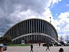 |
North Carolina State Fairgrounds, W. Hillsborough St. 35°47′37"N 78°42′36"W |
Raleigh | ||
| 84 | J. Beale Johnson House | 6321 Johnson Pond Rd. 35°36′40"N 78°45′21"W |
Fuquay-Varina | |||
| 85 | Kemp B. Johnson House | 7116 Johnson Pond Rd. 35°35′58"N 78°45′49"W |
Fuquay-Varina | |||
| 86 | Alpheus Jones House | NE of Raleigh on U.S. 401 35°51′50"N 78°32′50"W |
Raleigh | |||
| 87 | Crabtree Jones House | N of Raleigh off Old Wake Forest Rd. 35°49′24"N 78°37′29"W |
Raleigh | |||
| 88 | Nancy Jones House | NC 54 35°47′54"N 78°48′9"W |
Cary | |||
| 89 | Jones-Johnson-Ballentine Historic District | SR 1301-522 Sunset Rd. 35°36′36"N 78°46′21"W |
Fuquay-Varina | |||
| 90 | Henry L. Kamphoefner House Henry L. Kamphoefner House The Henry L. Kamphoefner House was the first Modernist house built in Raleigh, North Carolina. During the mid-20th century, faculty members from the School of Design located at North Carolina State College designed and built several modernist houses in Raleigh for themselves, other faculty, and a... |
 |
3060 Granville Dr. 35°49′21"N 78°39′46"W |
Raleigh | ||
| 91 | Henry H. and Bettie S. Knight Farm | US 64 35°48′4"N 78°29′34"W |
Knightdale | |||
| 92 | Joel Lane House Joel Lane House The Joel Lane House, built between 1760 and 1770, is a historic restored home and museum located in Raleigh, North Carolina. It is the oldest dwelling in Raleigh and contains collections of 18th century artifacts and period furnishings. The museum grounds include a detached kitchen, formal city... |
728 W. Hargett St. 35°46′40"N 78°39′3"W |
Raleigh | |||
| 93 | Lane-Bennett House | 7408 Ebenezer Church Rd. 35°52′17"N 78°44′27"W |
Raleigh | |||
| 94 | Rev. M.L. Latta House Rev. M.L. Latta House The Rev. M.L. Latta House was a historic home located in the Oberlin neighborhood of Raleigh, North Carolina. It was the last remaining building from Latta University, a trade school for African-Americans that operated from 1892 until 1920. The house was named after Morgan London Latta, a former... |
1001 Parker St. 35°47′53"N 78°39′47"W |
Raleigh | Burned on January 8, 2007. | ||
| 95 | Calvin Wray Lawrence House | 8528 Ragan Rd. 35°43′0.03"N 78°56′22.56"W |
Apex | |||
| 96 | Dr. Elmo N. Lawrence House | 2121 Lake Wheeler Rd. 35°45′9"N 78°40′5"W |
Raleigh | |||
| 97 | Lea Laboratory | Southeastern Baptist Theological Seminary campus 35°58′52"N 78°30′42"W |
Wake Forest | |||
| 98 | Leslie-Alford-Mims House | 100 Avent Ferry Rd. 35°39′7"N 78°50′11"W |
Holly Springs | |||
| 99 | Lewis-Smith House | N. Blount St. 35°47′8"N 78°38′8"W |
Raleigh | |||
| 100 | Longview Gardens Historic District | Bounded roughly by King Charles Rd., Poole Rd., Donald Ross Dr., Albemarle Ave., Longview Lake Dr., and New Bern Ave. 35°46′37"N 78°35′50"W |
Raleigh | Post-World War II and Modern Architecture in Raleigh, North Carolina, 1945-1965 MPS | ||
| 101 | Lumsden-Boone Building Lumsden-Boone Building The Lumsden-Boone Building is a historic commercial building located at 226 Fayetteville Street in the Fayetteville Street Historic District of Raleigh, North Carolina, United States. Constructed in 1896 for tin and hardware dealer J.C.S. Lumsden, the building is the only surviving metal-front... |
226 Fayetteville St. Mall 35°46′38"N 78°38′23"W |
Raleigh | |||
| 102 | Madonna Acres Historic District | Delany Dr., Dillon, Summerville, and Tierney Circles 35°47′27"N 78°36′55"W |
Raleigh | |||
| 103 | Mahler and Carolina Trust Buildings | 228-232 Fayetteville St. Mall 35°46′38"N 78°38′23"W |
Raleigh | |||
| 104 | Maiden Lane Historic District Maiden Lane Historic District The Maiden Lane Historic District is a neighborhood located in Raleigh, North Carolina. In 2006, the district was listed on the National Register of Historic Places.-External Links:* , Raleigh Historic Districts Commission... |
2-20 Maiden Ln. 35°47′19"N 78°39′47"W |
Raleigh | |||
| 105 | James Mangum House James Mangum House The James Mangum House is a historic home located near Creedmoor, North Carolina. The house, built in 1838, is an example of Federal architecture... |
SW of Durham off NC 751 35°49′42"N 78°59′24"W |
Creedmoor | Creedmoor is in Granville County. The geocode coordinates in the NRIS are in Chatham County. NC-751 SW of Durham places the site in either Durham or Chatham County. | ||
| 106 | Marshall-Harris-Richardson House | 116 N. Person St. 35°46′53"N 78°38′5"W |
Raleigh | |||
| 107 | Mary Elizabeth Hospital | 1100 Wake Forest Rd. 35°47′36.7"N 78°37′52.72"W |
Raleigh | |||
| 108 | Masonic Temple Building | 427 S. Blount St. 35°46′27"N 78°38′12"W |
Raleigh | |||
| 109 | Masonic Temple Building |  |
133 Fayetteville St. Mall 35°46′42"N 78°38′21"W |
Raleigh | ||
| 110 | Matsumoto House | 821 Runnymeade Rd. 35°48′55"N 78°40′31"W |
Raleigh | |||
| 111 | Meadowbrook Country Club | 8025 Country Club Dr. 35°39′37.2"N 78°34′9.68"W |
Garner | |||
| 112 | Merrimon House | 526 N. Wilmington St. 35°47′13"N 78°38′14"W |
Raleigh | |||
| 113 | Midway Plantation House and Outbuildings | 1625 Old Crews Rd. 35°49′24.36"N 78°29′13.03"W |
Knightdale | |||
| 114 | Montfort Hall Montfort Hall Montfort Hall is a home and registered historic landmark located in the Boylan Heights neighborhood of Raleigh, North Carolina. It is one of the few mansions in Raleigh that survived during the American Civil War era. The house was built for William Montfort Boylan in 1858 and is an example of... |
308 Boylan Ave. 35°46′35"N 78°39′4"W |
Raleigh | |||
| 115 | Moore Square Historic District Moore Square Historic District The Moore Square Historic District is a registered historic district located in downtown Raleigh, North Carolina. Listed on the National Register of Historic Places in 1983, the district is centered around Moore Square, one of two surviving four-acre parks from Raleigh's original 1792 plan... |
 |
Roughly bounded by Person, Morgan, Wilmington, and Davie Sts. 35°46′39"N 78°38′14"W |
Raleigh | ||
| 116 | Mordecai House Mordecai House The Mordecai House , built in 1785, is a registered historical landmark and museum in Raleigh, North Carolina that is the centerpiece of Mordecai Historic Park, right outside the Historic Oakwood neighborhood. It is the oldest residence in Raleigh on its original foundation... |
Mimosa St. 35°47′33"N 78°38′0"W |
Raleigh | Boundary increase (listed December 28, 2000): 208 Delway St. | ||
| 117 | Mordecai Place Historic District | Roughly bounded by N. Blount St., Courtland Dr., Old Wake Forest Rd., and Mordecai Dr.; also 208 Delway St. 35°47′30"N 78°37′58"W |
Raleigh | 208 Delway represents a boundary increase of | ||
| 118 | Mount Hope Cemetery | 1100 Fayetteville St. 35°45′56.93"N 78°38′34.85"W |
Raleigh | |||
| 119 | New Hill Historic District New Hill Historic District The New Hill Historic District is the commercial and residential center of New Hill, North Carolina, an unincorporated community in southwestern Wake County. The district includes , 59 buildings, and one structure. The predominant architectural styles of New Hill Historic District are Colonial... |
Roughly 0.5 miles south of the junction of Old U.S. Route 1 U.S. Route 1 U.S. Route 1 is a major north–south U.S. Highway that serves the East Coast of the United States. It runs 2,377 miles from Fort Kent, Maine at the Canadian border south to Key West, Florida. U.S. 1 generally parallels Interstate 95, though it is significantly farther west between... and NC 1127, and 2 miles west of the junction with Old U.S. Route 1 35°40′48"N 78°56′26"W |
New Hill | |||
| 120 | Norburn Terrace | 216 Lafayette St. 35°47′38"N 78°37′47"W |
Raleigh | |||
| 121 | North Carolina Agricultural Experiment Station Cottage | 2714 Vanderbilt Ave. 35°47′30"N 78°40′20"W |
Raleigh | |||
| 122 | North Carolina Executive Mansion North Carolina Executive Mansion The North Carolina Executive Mansion is the official residence of the Governor of North Carolina and his or her family. Building began in the year 1883 and it was designed by noted architects Samuel Sloan and A.G. Bauer. The first occupants, Governor Daniel G. Fowle and his family, moved into the... |
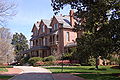 |
210 N. Blount St. 35°47′8"N 78°38′7"W |
Raleigh | ||
| 123 | North Carolina School for the Blind and Deaf Dormitory | 216 W. Jones St. 35°46′58"N 78°38′35"W |
Raleigh | |||
| 124 | North Carolina State Capitol North Carolina State Capitol The North Carolina State Capitol is the main house of government of the U.S. state of North Carolina. Housing the offices of the Governor of North Carolina, it is located in the state capital of Raleigh on Union Square at One East Edenton Street. The cornerstone of the Greek Revival building was... |
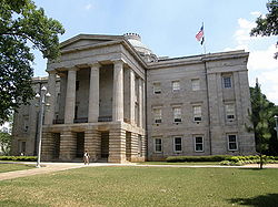 |
Capitol Sq. 35°46′59"N 78°38′20"W |
Raleigh | ||
| 125 | North Carolina State Fair Commercial & Education Buildings | NW corner Jct. of Blue Ridge Rd. and Hillsborough St. 35°47′40"N 78°42′28"W |
Raleigh | |||
| 126 | Oak View | Jct. of Poole Rd. and Raleigh Beltline 35°46′10"N 78°34′20"W |
Raleigh | |||
| 127 | Oakforest | 9958 Seawell Dr. 35°56′31"N 78°31′27"W |
Wake Forest | |||
| 128 | Oakwood Historic District Oakwood Historic District (Raleigh, North Carolina) The Oakwood Historic District is a historic neighborhood in Raleigh, North Carolina that contains the city’s largest collection of Victorian architecture and many other early-to-mid twentieth century styles. It is Raleigh's earliest white middle-class suburb, and unlike later suburbs, it developed... |
Roughly bounded by N. Boundary, Person, Jones, and Linden Sts., and Oakwood Cemetery; also the eastern side of Linden Ave. and the northern side of the 700 block of E. Lane St.; also portions of N. and S. Bloodworth St., N. and S. East St., N. Person St., E. Morgan St., New Bern Ave., and E. Edenton St.; also roughly bounded by E. Franklin St., Wautauga St., Boundary St., and N. Bloodworth St. 35°47′14"N 78°38′20"W |
Raleigh | Second, third, and fourth sets of boundaries represent boundary increases of , , and respectively | ||
| 129 | Oaky Grove Oaky Grove Oaky Grove is a historic home located in Shotwell, North Carolina, a suburb of Raleigh. Built in 1818 by Thomas Price, Oaky Grove has been home to generations of the Price, Blake, and Doub families. Before the Civil War, the Price plantation consisted of of farm land... |
Jct. of NC 2506 and NC 2507, SE corner 35°44′23"N 78°26′18"W |
Shotwell | |||
| 130 | Occidental Life Insurance Company Building | 1001 Wade Ave. 35°47′55"N 78°39′25"W |
Raleigh | |||
| 131 | Odd Fellows Building Odd Fellows Building (Raleigh, North Carolina) The Odd Fellows Building in Raleigh, North Carolina, also known as the Commerce Building, is a skyscraper built in 1923. It reflects Late 19th and Early 20th Century American Movements architecture and Classical Revival architecture.... |
19 W Hargett St. 35°46′40"N 78°38′24"W |
Raleigh | |||
| 132 | Page-Walker Hotel Page-Walker Hotel The Page-Walker Hotel, also known as The Page-Walker Arts & History Center is an historic house museum and former hotel located in Cary, North Carolina. The founder of the town of Cary, Allison Francis Page, built the Second Empire style hotel in 1868, and J. R... |
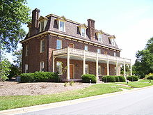 |
119 Ambassador St. 35°47′19"N 78°46′46"W |
Cary | ||
| 133 | Panther Branch School | NC 2727, 0.5 miles S of NC 183 35°37′59"N 78°38′28"W |
Raleigh | |||
| 134 | Paschal House | 3334 Alamance Dr. 35°49′41"N 78°39′48"W |
Raleigh | |||
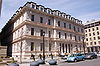
| 135 | Peace College Main Building Peace College Main Building Peace College Main Building is the focal point of the Peace College campus in Raleigh, North Carolina. Built between 1859 and 1862, Main Building is located at the northern end of Wilmington Street in downtown Raleigh and is considered one of the largest antebellum buildings surviving in the city... |
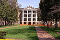 |
Peace St. and N end of Wilmington St. 35°47′21"N 78°38′18"W |
Raleigh | ||
| 136 | Jesse Penny House and Outbuildings | NC 1379, 1 miles SW of NC 1371 35°42′40"N 78°42′6"W |
Raleigh | |||
| 137 | Perry Farm Perry Farm The Perry Farm is an intact, historic African-American farm complex in Riley Hill, North Carolina, a suburb of Raleigh. The farm house was built in 1820 by John and Nancy Perry, white owners of several slaves during the Antebellum period of the South.... |
NC 2320 S side, E of jct. with NC 2300 35°51′7"N 78°24′9"W |
Riley Hill | |||
| 138 | Pilot Mill | 1121 Haynes St. 35°47′43"N 78°38′17"W |
Raleigh | |||
| 139 | Pine Hall | 5300 Castlebrook Dr. 35°49′18"N 78°32′59"W |
Raleigh | |||
| 140 | Pine State Creamery, (Former) | 414 Glenwood Ave. 35°47′8"N 78°38′49"W |
Raleigh | |||
| 141 | Leonidas L. Polk House | 612 N. Blount St. 35°47′18"N 78°38′9"W |
Raleigh | |||
| 142 | Wayland E. Poole House Wayland E. Poole House The Wayland E. Poole House is a historic home located near Auburn, North Carolina, a suburb of the state capital Raleigh. Built in 1911, the house is a Queen Anne cross-gabled frame building with a wraparound porch. In September 2003, the Waylard E. Poole House was listed on the National Register... |
NC 2555, 0.2 miles S of jct. with NC 1004 (4800 Auburn-Knightdale Rd.) 35°41′31"N 78°33′2"W |
Auburn | |||
| 143 | Dr. M.T. Pope House Pope House Museum The Pope House Museum, built in 1901, is a restored home once owned by Dr. M.T. Pope, a prominent African-American citizen of Raleigh, North Carolina... |
 |
511 S Wilmington St. 35°46′24"N 78°38′19"W |
Raleigh | ||
| 144 | Powell House | SW of Wake Forest off U.S. 1 35°55′24"N 78°32′33"W |
Wake Forest | |||
| 145 | Professional Building | 123-127 W. Hargett and McDowell Sts. 35°46′42"N 78°38′28"W |
Raleigh | |||
| 146 | Pugh House | 10018 Chapel Hill Rd. 35°49′30"N 78°49′30"W |
Morrisville | |||
| 147 | Pullen Park Carousel Pullen Park Carousel The Pullen Park Carousel is a classic wood carousel at Pullen Park in Raleigh, North Carolina. Built in 1900, the carousel contains 52 hand-carved basswood animals, 2 chariots , 18 large gilded mirrors and canvas panels and a Wurlitzer 125 organ made in 1924 by the Rudolph Wurlitzer Company of... |
 |
Pullen Park, Western Blvd. 35°46′46"N 78°39′52"W |
Raleigh | ||
| 148 | Purefoy-Chappell House and Outbuildings | 1255 S. Main St. 35°57′43.29"N 78°31′5.08"W |
Wake Forest | |||
| 149 | Purefoy-Dunn Plantation | E side US 1, .3 miles N of US 1A 35°57′32"N 78°32′19"W |
Wake Forest | |||
| 150 | Raleigh Banking and Trust Company Building | 5 W. Hargett St. 35°46′39"N 78°38′23"W |
Raleigh | |||
| 151 | Raleigh Bonded Warehouse | 1505 Capital Blvd. 35°48′7"N 78°37′43"W |
Raleigh | |||
| 152 | Raleigh Electric Company Power House | 513-515 W. Jones St. 35°46′56"N 78°38′48"W |
Raleigh | |||
| 153 | Raleigh National Cemetery Raleigh National Cemetery Raleigh National Cemetery is a United States National Cemetery located in the city of Raleigh in Wake County, North Carolina. It encompasses , and as of the end of 2005, had 5,983 interments... |
501 Rock Quarry Rd. 35°46′25"N 78°37′14"W |
Raleigh | |||
| 154 | Raleigh Water Tower Raleigh Water Tower The Raleigh Water Tower is a historic building that was the first water tower built in Raleigh, North Carolina. Constructed in 1887, the City of Raleigh relied on the tower for 37 years until it was decommissioned in 1924... |
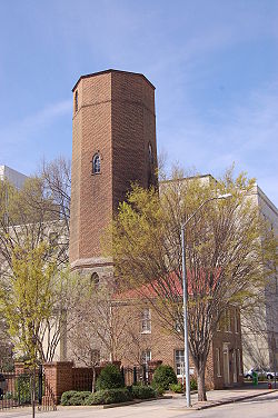 |
115 W. Morgan St. 35°46′45"N 78°38′42"W |
Raleigh | ||
| 155 | Raleigh Water Works and E.B. Bain Water Treatment Plant | 1810 Fayetteville Rd. 35°45′28"N 78°38′33"W |
Raleigh | |||
| 156 | Sir Walter Raleigh Hotel Sir Walter Raleigh Hotel The Sir Walter Raleigh Hotel is the oldest surviving hotel building in Raleigh, North Carolina. Constructed between 1923 and 1924 on Fayetteville Street and named after Sir Walter Raleigh, the hotel was nicknamed North Carolina’s “third house of government,” due to its location and being a focal... |
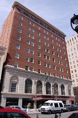 |
400-412 Fayetteville St. 35°46′31"N 78°38′24"W |
Raleigh | ||
| 157 | Riley Hill School Riley Hill School Riley Hill School is a historic educational building located in Wendell, North Carolina, a town in eastern Wake County. Built in 1928, the school is an example of Colonial Revival architecture. In April 2001, Riley Hill School was listed on the National Register of Historic Places.... |
NC 2320, 0.2 miles E of NC2318 35°51′34"N 78°24′59"W |
Wendell | |||
| 158 | Ritcher House Ritcher House The Ritcher House is considered to be one of the best examples of Frank Lloyd Wright's Usonian mode of design in North Carolina. Located near downtown Raleigh, the house is one of many Modernist houses that were built in the city during the mid-20th century. Most of these homes were designed by... |
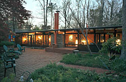 |
3039 Churchill Rd. 35°48′20"N 78°40′39"W |
Raleigh | ||
| 159 | Roanoke Park Historic District | Roughly bounded by Whitaker Mill Rd. Fairview Rd. Morrison Ave., Sunrise Ave. and Brickett Blvd. 35°48′10"N 78°38′30"W |
Raleigh | |||
| 160 | Rock Cliff Farm | western end of Bent Rd. 35°59′59.09"N 78°38′47.26"W |
Wake Forest | |||
| 161 | Rogers-Bagley-Daniels-Pegues House | 125 E. South St. 35°46′19"N 78°38′15"W |
Raleigh | |||
| 162 | Rogers-Whitaker-Haywood House Rogers-Whitaker-Haywood House The Rogers-Whitaker-Haywood House is a historic home in Wake Crossroads, North Carolina, an unincorporated community northeast of the state capital Raleigh. Built in 1771, the house is an example of Federal architecture. In September 1985, the Rogers-Whitaker-Haywood House was listed on the... |
NC 2044 and U.S. Route 401 35°53′50"N 78°30′30"W |
Raleigh | |||
| 163 | Mae and Philip Rothstein House | 912 Williamson Dr. 35°48′3"N 78°39′6"W |
Raleigh | |||
| 164 | Royal Baking Company | 3801 Hillsborough St. 35°47′38"N 78°41′18"W |
Raleigh | |||
| 165 | Royall Cotton Mill Commissary | Jct. of Brick and Brewer Sts. 35°59′21"N 78°30′5"W |
Wake Forest | |||
| 166 | Seaboard Coast Line Railroad Company Office Building | Wilmington St. 35°47′9"N 78°38′44"W |
Raleigh | |||
| 167 | Small House | 310 Lake Boone Trail 35°48′59"N 78°39′55"W |
Raleigh | |||
| 168 | G. Milton Small and Associates Office Building | 105 Brooks Ave. 35°47′22"N 78°40′25"W |
Raleigh | |||
| 169 | Frank and Mary Smith House Frank and Mary Smith House The Frank and Mary Smith House is a historic home located in Willow Spring, North Carolina, a suburb of Raleigh. The house was built in 1880 and listed on the National Register of Historic Places in September 2003.... |
2935 John Adams Rd. 35°34′34"N 78°41′7"W |
Willow Spring | |||
| 170 | Turner and Amelia Smith House Turner and Amelia Smith House The Turner and Amelia Smith House is a historic home in Willow Spring, North Carolina, a suburb of Raleigh. The house was built in 1880 and listed on the National Register of Historic Places in July 2005.... |
12244 Old Stage Rd. 35°34′44"N 78°41′38"W |
Willow Spring | |||
| 171 | Spring Hill | 705 Barbour Dr. 35°46′21"N 78°40′34"W |
Raleigh | |||
| 172 | St. Augustine's College Campus | Oakwood Ave. 35°47′8"N 78°37′19"W |
Raleigh | |||
| 173 | St. Mary's Chapel St. Mary's Chapel (Raleigh, North Carolina) St. Mary's Chapel is a historic Episcopal chapel at 900 Hillsborough Street in Raleigh, North Carolina on the grounds of St. Mary's School.It was built by Richard Upjohn in 1855 and added to the National Register of Historic Places in 1970 as a Historic Place in Wake County, North... |
900 Hillsborough St. 35°46′54"N 78°39′11"W |
Raleigh | |||
| 174 | St. Mary's College | St. Marys and Hillsborough Sts. 35°46′56"N 78°39′9"W |
Raleigh | |||
| 175 | St. Matthews School | US 401, 0.5 mi NE of NC 2213 35°51′37"N 78°33′41"W |
Raleigh | |||
| 176 | St. Paul A.M.E. Church | 402 W. Edenton St. 35°46′54"N 78°38′44"W |
Raleigh | |||
| 177 | State Bank of North Carolina State Bank of North Carolina The State Bank of North Carolina is the oldest surviving commercial building in Raleigh, North Carolina and was the first state-sponsored banking institution constructed in North Carolina. The bank was incorporated in 1810, but during the War of 1812 cash was moved inland to banks in Raleigh and... |
 |
11 New Bern Ave. 35°46′59"N 78°38′15"W |
Raleigh | ||
| 178 | Sunnyside Sunnyside (Wendell, North Carolina) Sunnyside is a historic home located in Wendell, North Carolina, a town in eastern Wake County. The Craftsman and Greek Revival house was built in 1918 by R. B. Whitley, a prominent Wendell businessman who founded the Bank of Wendell in 1907.... |
210 S. Selma Rd. 35°46′39"N 78°21′46"W |
Wendell | |||
| 179 | Thompson House | 2528 Old NC 98 35°58′10"N 78°34′8"W |
Wake Forest | |||
| 180 | Tucker Carriage House | 100 block of St. Mary 35°46′55"N 78°39′2"W |
Raleigh | |||
| 181 | John T. and Mary Turner House | 1002 Oberlin Rd. 35°47′52"N 78°39′37"W |
Raleigh | |||
| 182 | Utley-Council House | NC 1390, near jct. with NC 1387 35°39′48"N 78°46′2"W |
Apex | |||
| 183 | Vanguard Park Historic District | Roughly bounded by McCarthy St., Whitaker Mill Rd., Pine Ave., and Hudson St. 35°48′25.65"N 78°38′20.39"W |
Raleigh | |||
| 184 | Varina Commercial Historic District | Broad and Fayetteville Sts. between Stewart St. and Ransdell Rd. 35°35′34"N 78°47′40"W |
Fuquay-Varina | |||
| 185 | Wake Forest Historic District | Bounded by Oak St., RR tracks, Holding St., W. Vernon Ave., S. Wingate, N. Wingate, Durham Rd. and N. College Sts. 35°58′55"N 78°30′44"W |
Wake Forest | |||
| 186 | Wakefield Dairy Complex | W side Falls of Neuse Rd., 1.2 miles N of Neuse R. 35°57′28"N 78°34′7"W |
Wake Forest | |||
| 187 | Wakefields | SE of Creedmoor off U.S. 15A 36°0′8"N 78°31′23"W |
Wake Forest | |||
| 188 | Wakelon School Wakelon School The Wakelon School is a historic educational building located in Zebulon, North Carolina, a suburb of Raleigh. Wakelon was built in 1908 and served as an elementary school until the student population became too large for the facility. GlaxoSmithKline purchased Wakelon School from the Town of... |
Arendell St. 35°49′51"N 78°19′15"W |
Zebulon | |||
| 189 | Walnut Hill Cotton Gin | NC 2509 35°43′58"N 78°27′17"W |
Knightdale | |||
| 190 | Walnut Hill Historic District | Along Mial Plantation Rd., jct with Major Slade Rd. and Smithfield Rd. 35°44′2"N 78°26′44"W |
Knightdale | |||
| 191 | Washington Graded and High School | 1000 Fayetteville St. 35°46′8"N 78°38′39"W |
Raleigh | |||
| 192 | Paul and Ellen Welles House | 3227 Birnamwood Rd. 35°46′8"N 78°38′39"W |
Raleigh | |||
| 193 | Wendell Boulevard Historic District | Roughly bounded by Wendell Blvd., Mattox St., Old Zebulon Rd., Buffalo St. and Main St. 35°47′3.73"N 78°21′58.4"W |
Wendell | |||
| 194 | Wendell Commercial Historic District Wendell Commercial Historic District The Wendell Commercial Historic District is the historic downtown of Wendell, North Carolina, a town in eastern Wake County. In July 1998, the district was listed on the National Register of Historic Places.... |
Roughly along jct. of Main St. and Third St. 35°46′52"N 78°22′15"W |
Wendell | |||
| 195 | West Raleigh Historic District West Raleigh Historic District The West Raleigh Historic District in Raleigh, North Carolina is a historic district listed on the National Register of Historic Places. Located 1.5 miles west-northwest of the State Capitol, the district encompasses approximately... |
Roughly bounded by Mayview Rd., Enterprise St., Hillsbourgh St. and Faircloth St. 35°47′42"N 78°40′24"W |
Raleigh | |||
| 196 | White-Holman House | .jpg) |
New Bern Ave. 35°46′46"N 78°38′11"W |
Raleigh | ||
| 197 | Leonidas R. Wyatt House | 107 S Bloodworth St. 35°46′43"N 78°37′59"W |
Raleigh | |||
| 198 | Yates Mill Yates Mill Yates Mill is a fully restored, circa 1756 gristmill located five miles south of downtown Raleigh, North Carolina. It is the centerpiece of Historic Yates Mill County Park, located in central Wake County... |
Lake Wheeler Rd. 35°43′7"N 78°41′18"W |
Raleigh | |||
| 199 | Dr. Lawrence Branch Young House Dr. Lawrence Branch Young House The Dr. Lawrence Branch Young House is a historic home located in Rolesville, North Carolina, a satellite town of the state capital Raleigh. Built in 1903, the Young house is the only example of Queen Anne and Colonial Revival architecture in Rolesville. The two-story white house features a... |
119 W. Young St. 35°55′40"N 78°27′28"W |
Rolesville |
See also
- National Register of Historic Places listings in North Carolina
- List of National Historic Landmarks in North Carolina
External Links
- National Register Historic Districts in Raleigh, North Carolina, Raleigh Historic Districts Commission