

National Register of Historic Places listings in Deer Lodge County, Montana
Encyclopedia
National Register of Historic Places
The National Register of Historic Places is the United States government's official list of districts, sites, buildings, structures, and objects deemed worthy of preservation...
in Deer Lodge County
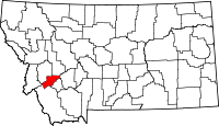
Deer Lodge County, Montana
-National protected areas:*Beaverhead National Forest *Deerlodge National Forest -Demographics:As of the census of 2000, there were 9,417 people, 3,995 households, and 2,524 families residing in the county. The population density was 13 people per square mile . There were 4,958 housing units at an...
, Montana
Montana
Montana is a state in the Western United States. The western third of Montana contains numerous mountain ranges. Smaller, "island ranges" are found in the central third of the state, for a total of 77 named ranges of the Rocky Mountains. This geographical fact is reflected in the state's name,...
, United States
United States
The United States of America is a federal constitutional republic comprising fifty states and a federal district...
. All sites are located in the city of Anaconda
Anaconda, Montana
Anaconda, county seat of Anaconda City/Deer Lodge County, is located in mountainous southwestern Montana. The Continental Divide passes within 8 miles of the community with the local Pintler Mountain range reaching 10,379 feet...
, which is consolidated
Consolidated city-county
In United States local government, a consolidated city–county is a city and county that have been merged into one unified jurisdiction. As such it is simultaneously a city, which is a municipal corporation, and a county, which is an administrative division of a state...
with Deer Lodge County. The locations of National Register properties and districts for which the latitude and longitude coordinates are included below, may be seen in a Google map.
There are 33 properties and districts listed on the National Register in the county, including 1 National Historic Landmark
National Historic Landmark
A National Historic Landmark is a building, site, structure, object, or district, that is officially recognized by the United States government for its historical significance...
.
Listings county-wide
| Landmark name | Image | Date listed | Location | Summary | |
|---|---|---|---|---|---|
| 1 | Alpine Apartments | 200 Hickory 46°7′46"N 112°57′13"W |
|||
| 2 | Anaconda Commercial Historic District | Roughly bounded by Commercial Ave., Main St., Chestnut St., and E. Park Ave. 46°7′46"N 112°56′57"W |
|||
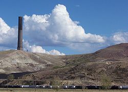
| 3 | Anaconda Copper Mining Company Smoke Stack Anaconda Smelter Stack The Anaconda Smelter Stack is a radial brick smoke stack, once part of the Anaconda Smelter at Anaconda, Montana in the United States. The stack rests on a concrete foundation and measures 585 feet 1.5 inches high. The inside diameter of the stack is at the bottom and at the top... |
 |
Anaconda Copper Smelter 46°6′37"N 112°54′47"W |
||
| 4 | Anaconda Saddle Club | 2704 Montana Highway 1, W. | |||
| 5 | Ancient Order of Hibernians Hall Ancient Order of Hibernians Hall The Ancient Order of Hibernians Hall, also known as Hibernian Hall, in Anaconda, Montana was built in 1899. It was listed on the National Register of Historic Places in 1979.... |
321-323 E. Commercial 46°7′46"N 112°56′54"W |
|||
| 6 | Barich Block | 416-420 E. Park Ave. 46°7′47"N 112°57′5"W |
|||
| 7 | Branscombe Automobile Machine Shop | 125 W. Commercial 46°7′56"N 112°57′14"W |
|||
| 8 | Butte, Anaconda and Pacific Railway Historic District | Right-of-way begins in Butte and travels to Anaconda, generally along the course of Silver Bow Creek 46°2′37"N 112°44′25"W |
Extends into Silver Bow County | ||
| 9 | Butte-Anaconda Historic District Butte-Anaconda Historic District Butte-Anaconda Historic District is a historic district that spans parts of Walkerville, Butte and Anaconda, Montana. It has the most resources of any U.S... |
Most of the developed areas of Anaconda, Butte, and Walkerville 46°7′45"N 112°57′10"W |
Extends into Silver Bow County | ||
| 10 | California Creek Quarry | Address Restricted | |||
| 11 | City Hall | 401 E. Commercial 46°7′46"N 112°56′51"W |
|||
| 12 | Club Moderne Club Moderne The Club Moderne is a bar in Anaconda, Montana in the Streamline Moderne style. It was designed by archtitect Fred F. Willson.-External links:*, at Historic American Building Survey... |
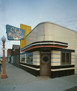 |
811 E. Park 46°7′40"N 112°56′38"W |
||
| 13 | James V. Collins House | 422 W. 3rd St. 46°7′52"N 112°57′31"W |
|||
| 14 | Davidson Building | 301-303 E. Park St. 46°7′47"N 112°57′14"W |
|||
| 15 | Deer Lodge County Courthouse | 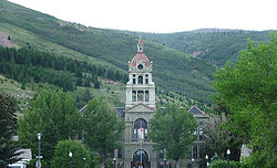 |
U.S. Route 10 U.S. Route 10 U.S. Route 10 is an east–west United States highway formed in 1926. Though it never became the cross-country highway suggested by the "0" as the last digit of its route number, U.S... 46°7′21"N 112°57′18"W |
||
| 16 | Theodore Eck House | 1217 W. 4th St. 46°7′48"N 112°58′10"W |
|||
| 17 | John Furst House | 1403 W. 3rd St. 46°7′53"N 112°58′16"W |
|||
| 18 | Glover Cabin | Washoe Park 46°8′10"N 112°57′56"W |
|||
| 19 | Goosetown Historic District | Roughly bounded by Cedar St., Monroe St., the Birch Hill Allotment, and E. Commercial Ave. 46°7′28"N 112°56′35"W |
|||
| 20 | Granite Apartments | 214 E. 3rd St. 46°7′48"N 112°57′4"W |
|||
| 21 | Hearst Free Library | Main and 4th Sts. 46°7′37"N 112°57′9"W |
|||
| 22 | Lorraine Apartments | 218 E. 3rd 46°7′47"N 112°57′2"W |
|||
| 23 | Duncan Matheson House | 1300 W. 3rd St. 46°7′53"N 112°58′10"W |
|||
| 24 | Methodist Episcopal Church of Anaconda | Junction of Oak and E. 3rd Sts. 46°7′42"N 112°57′2"W |
|||
| 25 | Morel Bridge | 25200 East Side Rd. 46°9′28"N 112°46′16"W |
|||
| 26 | The New Brunswick House | 325 E. Front 46°7′56"N 112°56′54"W |
|||
| 27 | Sheehan Boardinghouse | 412 E. 3rd St. 46°7′42"N 112°56′54"W |
|||
| 28 | St. Mark's Episcopal Church | 601 Main St. 46°7′29"N 112°57′14"W |
|||
| 29 | US Post Office-Anaconda Main | 218 Main St. 46°7′44"N 112°57′9"W |
|||
| 30 | George Waddell House | 506 W. 3rd St. 46°7′46"N 112°57′30"W |
|||
| 31 | Washoe Theater Washoe Theater The Washoe Theater in Anaconda, Montana was the last theater constructed in the United States in the Nuevo Deco style. The theater was designed in 1930 by Seattle architect B. Marcus Priteca. It was almost entirely finished by 1931, but its opening was delayed until Thursday, September 24, 1936... |
305 Main St. 46°7′39"N 112°57′8"W |
|||
| 32 | West Side Historic District | Roughly bounded by Main St., W. 8th St., W. Park Ave., and Maple St. 46°7′33"N 112°57′17"W |
|||
| 33 | Zion Swedish Evangelical Lutheran Church | 524 Cedar St. 46°7′29"N 112°56′57"W |
See also
- List of National Historic Landmarks in Montana
- National Register of Historic Places listings in Montana