
Napeague, New York
Encyclopedia
Census-designated place
A census-designated place is a concentration of population identified by the United States Census Bureau for statistical purposes. CDPs are delineated for each decennial census as the statistical counterparts of incorporated places such as cities, towns and villages...
(CDP) that roughly corresponds to the hamlet (unincorporated community) with the same name in the town of East Hampton
East Hampton (town), New York
The Town of East Hampton is located in southeastern Suffolk County, New York, at the eastern end of the South Shore of Long Island. It is the easternmost town in the state of New York...
in Suffolk County
Suffolk County, New York
Suffolk County is a county located in the U.S. state of New York on the eastern portion of Long Island. As of the 2010 census, the population was 1,493,350. It was named for the county of Suffolk in England, from which its earliest settlers came...
, New York
New York
New York is a state in the Northeastern region of the United States. It is the nation's third most populous state. New York is bordered by New Jersey and Pennsylvania to the south, and by Connecticut, Massachusetts and Vermont to the east...
, United States
United States
The United States of America is a federal constitutional republic comprising fifty states and a federal district...
. The CDP population was 223 at the 2000 census.
Napeague is located on a very narrow, low lying strip between the Atlantic Ocean
Atlantic Ocean
The Atlantic Ocean is the second-largest of the world's oceanic divisions. With a total area of about , it covers approximately 20% of the Earth's surface and about 26% of its water surface area...
to the south and Gardiners Bay
Gardiners Bay
Gardiners Bay is a small arm of the Atlantic Ocean, approximately 10 mi long and 8 mi wide in the U.S. state of New York between the two flukelike peninsulas at the eastern end of Long Island...
to the north that was flooded in the Great Hurricane of 1938. It lies between Napeague State Park
Napeague State Park
Napeague State Park is a park on either side of the Montauk Highway, Route 27, on the "Napeague Stretch" between Amagansett, New York and Montauk, New York, in the United States...
on the west and Hither Hills State Park
Hither Hills State Park
Hither Hills State Park is a state park located on the southern shore near the eastern tip of Long Island in Suffolk County, New York in the USA.The park is located on the South Fork of Long Island at Napeague, New York...
on the east.
Napeague derives its name from the Montaukett
Montaukett
The Montaukett is an Algonquian-speaking Native American group native to the eastern end of Long Island, New York and one of the thirteen historical indigenous centers...
name for "land overflowed by the sea."
Landmark structures
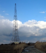
The hamlet's three major landmarks are the Mackay Radio Tower, the Art Barge, and the Smith Meal Fish Factory.Mackay Radio Tower
The Mackay Radio Tower is the last of two towers (originally 300 feet (91.4 m) high 1000 feet (304.8 m) apart) that was used to transmit international point to point radio communications starting in 1927. At the height of World War IIWorld War II
World War II, or the Second World War , was a global conflict lasting from 1939 to 1945, involving most of the world's nations—including all of the great powers—eventually forming two opposing military alliances: the Allies and the Axis...
the tower was used for responding to upwards of ten SOS
SOS
SOS is the commonly used description for the international Morse code distress signal...
calls a day from ships at sea. The tower had somebody on site 24 hours a day but the actual transmissions were keyed from Southampton
Southampton (village), New York
Southampton is a village in Suffolk County, New York, USA. The village is named after the Earl of Southampton. The Village of Southampton is in the southeast part of the county in the Town of Southampton...
. The towers toppled during the Great 1938 Hurricane.
At 12:35 pm. on January 28, 1961 an American Airlines
American Airlines
American Airlines, Inc. is the world's fourth-largest airline in passenger miles transported and operating revenues. American Airlines is a subsidiary of the AMR Corporation and is headquartered in Fort Worth, Texas adjacent to its largest hub at Dallas/Fort Worth International Airport...
Boeing 707
Boeing 707
The Boeing 707 is a four-engine narrow-body commercial passenger jet airliner developed by Boeing in the early 1950s. Its name is most commonly pronounced as "Seven Oh Seven". The first airline to operate the 707 was Pan American World Airways, inaugurating the type's first commercial flight on...
Flight 1502 (Flagship Oklahoma) with an engine on fire nosedived over the towers before crashing about 300 yards off the Napeague coast killing all six aboard. The plane had been on a training flight from Idlewild Airport. An often repeated story says the plane clipped one of the towers but The New York Times account of the crash says it just missed the towers.
The Mackay towers were decommissioned in 1984 and its underlying land is part of Napeague State Park
Napeague State Park
Napeague State Park is a park on either side of the Montauk Highway, Route 27, on the "Napeague Stretch" between Amagansett, New York and Montauk, New York, in the United States...
. One of the towers was torn down. The remaining tower is used for communication purposes by the New York State Police
New York State Police
The New York State Police is the state police force of over 4,600 sworn Troopers for the state of New York. It was established on April 11, 1917 by the New York Legislature, in response to the 1913 murder of a construction foreman named Sam Howell in Westchester County, which at that time did not...
. Its flashing white lights are visible throughout coastal areas of East Hampton.
Art Barge
The Art Barge is the home of the Victor D'Amico Institute of Art. Victor D'Amico was Director of Education for the Museum of Modern ArtMuseum of Modern Art
The Museum of Modern Art is an art museum in Midtown Manhattan in New York City, on 53rd Street, between Fifth and Sixth Avenues. It has been important in developing and collecting modernist art, and is often identified as the most influential museum of modern art in the world...
from 1937 until 1970. In 1955 the Department had begun art classes at Ashawagh Hall in Springs, New York
Springs, New York
Springs is a census-designated place roughly corresponding to the hamlet by the same name in the town of East Hampton in Suffolk County, New York on the South Fork of Long Island. As of the United States 2000 Census, the hamlet population was 4,950...
. D’Amico, looking for a permanent home, worked with local baymen to dock a barge at its current location just northeast of the Mackay Towers. It was originally called Kearsarge, a Native American word meaning "place of heaven.” However the popular name of art barge stuck. A second story was added later. The barge now operates June through September.
Smith Meal Fish Factory
The large shed of the Smith Meal Fish Factory in Promised Land was a plant that processed menhadenMenhaden
Menhaden, also known as mossbunker, bunker and pogy, are forage fish of the genera Brevoortia and Ethmidium, two genera of marine fish in the family Clupeidae.-Description:...
fish for fish meal
Fish meal
Fish meal, or fishmeal, is a commercial product made from both whole fish and the bones and offal from processed fish. It is a brown powder or cake obtained by rendering pressing the cooked whole fish or fish trimmings to remove most of the fish oil and water, and then ground...
. It was owned by Otis Smith and produced between 20-30 million fish a year from June to October and had its own Long Island Rail Road
Long Island Rail Road
The Long Island Rail Road or LIRR is a commuter rail system serving the length of Long Island, New York. It is the busiest commuter railroad in North America, serving about 81.5 million passengers each year. Established in 1834 and having operated continuously since then, it is the oldest US...
siding
Siding
Siding is the outer covering or cladding of a house meant to shed water and protect from the effects of weather. On a building that uses siding, it may act as a key element in the aesthetic beauty of the structure and directly influence its property value....
. After a drop in the supply of menhaden, Smith closed the plant in 1969 along with plants at Lewes, Delaware
Lewes, Delaware
Lewes is an incorporated city in Sussex County, Delaware, USA, on the Delmarva Peninsula. According to the 2010 census, the population is 2,747, a decrease of 6.3% from 2000....
and Crab Island, New Jersey. The plants were consolidated at Port Monmouth, New Jersey
Port Monmouth, New Jersey
Port Monmouth is a census-designated place and unincorporated area located within Middletown Township, in Monmouth County, New Jersey. As of the 2010 United States Census, the CDP population was 3,818.-Geography:...
. next to the smith meal plant is a private marine finfish hatchery Multi Aquaculture Systems and a small restaurant,the sea slug lounge .
The Smith Meal Fish Factory is part of the Napeague State Park and is the subject of an ongoing court battle about whether it should be used as a dock for the Cross Sound Ferry
Cross Sound Ferry
Cross Sound Ferry is a passenger and road vehicle ferry service operating between New London, Connecticut and Orient, Long Island, New York. The service is privately owned and operated by Cross Sound Ferry Services, Inc., headquartered in New London...
for a car ferry service to New London, Connecticut
New London, Connecticut
New London is a seaport city and a port of entry on the northeast coast of the United States.It is located at the mouth of the Thames River in New London County, southeastern Connecticut....
.
Water Sports
Napeague Harbor is also a well known kiteboardingKitesurfing
Kitesurfing or Kiteboarding is an adventure surface water sport that has been described as combining wakeboarding, windsurfing, surfing, paragliding, and gymnastics into one extreme sport. Kitesurfing harnesses the power of the wind to propel a rider across the water on a small surfboard or a...
and windsurfing
Windsurfing
Windsurfing or sailboarding is a surface water sport that combines elements of surfing and sailing. It consists of a board usually two to four metres long, powered by the orthogonal effect of the wind on a sail. The rig is connected to the board by a free-rotating universal joint and comprises a...
destination on Long Island. With flat waters and steady wind, Napeague is used by beginners and advanced riders.
Geography
According to the United States Census BureauUnited States Census Bureau
The United States Census Bureau is the government agency that is responsible for the United States Census. It also gathers other national demographic and economic data...
, the CDP has a total area of 10.6 square miles (27.5 km²), of which, 3.9 square miles (10.1 km²) of it is land and 6.7 square miles (17.4 km²) of it (63.22%) is water.
At the end of the last ice age, Napeague was submerged under the sea. (At that time, Montauk was an island.) In the intervening several thousand years, ocean currents, or littoral drift, filled in this space with sand, giving rise to Napeague.
The main settlement in Napeague is the small community of Lazy Point, also known as "Promised Land". It acquired this nickname, according to local lore, because of the menhaden plant located there in years gone by, which "stunk to high heaven".
Demographics
As of the censusCensus
A census is the procedure of systematically acquiring and recording information about the members of a given population. It is a regularly occurring and official count of a particular population. The term is used mostly in connection with national population and housing censuses; other common...
of 2000, there were 223 people, 105 households, and 64 families residing in the CDP. The population density
Population density
Population density is a measurement of population per unit area or unit volume. It is frequently applied to living organisms, and particularly to humans...
was 57.4 per square mile (22.2/km²). There were 624 housing units at an average density of 160.7/sq mi (62.1/km²). The racial makeup of the CDP was 97.31% White, 0.90% African American, 1.35% Native American, and 0.45% from two or more races. Hispanic or Latino of any race were 6.73% of the population.
There were 105 households out of which 17.1% had children under the age of 18 living with them, 46.7% were married couples
Marriage
Marriage is a social union or legal contract between people that creates kinship. It is an institution in which interpersonal relationships, usually intimate and sexual, are acknowledged in a variety of ways, depending on the culture or subculture in which it is found...
living together, 10.5% had a female householder with no husband present, and 39.0% were non-families. 33.3% of all households were made up of individuals and 10.5% had someone living alone who was 65 years of age or older. The average household size was 2.12 and the average family size was 2.59.
In the CDP the population was spread out with 15.2% under the age of 18, 6.3% from 18 to 24, 23.3% from 25 to 44, 32.3% from 45 to 64, and 22.9% who were 65 years of age or older. The median age was 48 years. For every 100 females there were 108.4 males. For every 100 females age 18 and over, there were 107.7 males.
The median income for a household in the CDP was $44,688, and the median income for a family was $48,333. Males had a median income of $37,500 versus $31,875 for females. The per capita income
Per capita income
Per capita income or income per person is a measure of mean income within an economic aggregate, such as a country or city. It is calculated by taking a measure of all sources of income in the aggregate and dividing it by the total population...
for the CDP was $23,403. About 9.7% of families and 13.3% of the population were below the poverty line, including 25.0% of those under the age of eighteen and none of those sixty five or over.