

Mzingwane River
Encyclopedia
The Mzingwane River is a major left-bank tributary of the Limpopo River
in Zimbabwe
.
It rises near Fort Usher, Matobo District, south of Bulawayo
and flows into the Limpopo River
near Beitbridge
, downstream of the mouth of the Shashe River
and upstream of the mouth of the Bubye River
.
Major tributaries of the Mzingwane River include the Insiza
, Inyankuni
, Ncema
, Umchabezi
(not to be confused with Mtshabezi
) and Mtetengwe
Rivers.
The lower Mzingwane River is a sand filled channel, with extensive alluvial aquifer
s in the river channel and below the alluvial plains. Estimated water resources potential of these aquifers ranges between 175,000 m3 and 5.43 Mm3 in the channels and between 80,000 m3 and 6.92 Mm3 in the plains. Currently, some of these aquifers are being used to provide water for domestic use, livestock watering and dip tanks, commercial irrigation and market gardening.
There are also a number of fords, including:
 In addition to a number of small weirs, there are two major dams on the Mzingwane River:
Additional dam sites have been identified at Glassblock
and Oakley Block
, but development is not currently scheduled .
Currently, a project is underway to construct a pipeline from the upper Mtshabezi River
(not to be confused with Umchabezi River
) to Mzingwane Dam
.
Limpopo River
The Limpopo River rises in central southern Africa, and flows generally eastwards to the Indian Ocean. It is around long, with a drainage basin in size. Its mean annual discharge is 170 m³/s at its mouth...
in Zimbabwe
Zimbabwe
Zimbabwe is a landlocked country located in the southern part of the African continent, between the Zambezi and Limpopo rivers. It is bordered by South Africa to the south, Botswana to the southwest, Zambia and a tip of Namibia to the northwest and Mozambique to the east. Zimbabwe has three...
.
It rises near Fort Usher, Matobo District, south of Bulawayo
Bulawayo
Bulawayo is the second largest city in Zimbabwe after the capital Harare, with an estimated population in 2010 of 2,000,000. It is located in Matabeleland, 439 km southwest of Harare, and is now treated as a separate provincial area from Matabeleland...
and flows into the Limpopo River
Limpopo River
The Limpopo River rises in central southern Africa, and flows generally eastwards to the Indian Ocean. It is around long, with a drainage basin in size. Its mean annual discharge is 170 m³/s at its mouth...
near Beitbridge
Beitbridge
Beitbridge or Mzingwane is a border town in the province of Matabeleland South, Zimbabwe. The name also refers to the border post and bridge spanning the Limpopo River, which forms the political border between South Africa and Zimbabwe.-Background:...
, downstream of the mouth of the Shashe River
Shashe River
The Shashe River is a major left-bank tributary of the Limpopo River in Zimbabwe.It rises northwest of Francistown, Botswana and flows into the Limpopo River where Botswana, Zimbabwe and South Africa meet, site of the Shalimpo Transfrontier Conservation Area.- Hydrology :The Shashe River is a...
and upstream of the mouth of the Bubye River
Bubye River
The Bubye River is a tributary of the Limpopo River in Beitbridge District and Gwanda District, Zimbabwe. There are no major dams on the river, although two sites have been identified.- References :...
.
Hydrology
The Mzingane River is an ephemeral river with flow generally restricted to the months when rain takes place (November to March), with most flow recorded between December and February, except where it has been modified by dam operations . The river contributes 9.3 % of the mean annual runoff of the Limpopo Basin, making it the third largest tributary to the Limpopo basin .Major tributaries of the Mzingwane River include the Insiza
Insiza River
The Insiza River is the principal tributary of the Mzingwane River in Zimbabwe.It rises near Fort Rixon, Insiza District, and flows into the Mzingwane River near West Nicholson.- Hydrology :...
, Inyankuni
Inyankuni River
Inyankuni River is a river in Zimbabwe....
, Ncema
Ncema River
Ncema River is a river in Zimbabwe....
, Umchabezi
Umchabezi River
The Umchabezi River is a tributary of the Mzingwane River in Beitbridge District and Gwanda District, Zimbabwe. The main dam on the river is Makado Dam, which supplies water for commercial irrigation.- References :...
(not to be confused with Mtshabezi
Mtshabezi River
The Mtshabezi River is a tributary of the Thuli River in southern Zimbabwe.- References :...
) and Mtetengwe
Mtetengwe River
The Mtetengwe River is a tributary of the Mzingwane River in Beitbridge District, Zimbabwe. There are two dams on its tributaries: Tongwe Dam on the Tongwe River, which provides water for an irrigation scheme, and Giraffe Dam which supplies water for cattle....
Rivers.
The lower Mzingwane River is a sand filled channel, with extensive alluvial aquifer
Aquifer
An aquifer is a wet underground layer of water-bearing permeable rock or unconsolidated materials from which groundwater can be usefully extracted using a water well. The study of water flow in aquifers and the characterization of aquifers is called hydrogeology...
s in the river channel and below the alluvial plains. Estimated water resources potential of these aquifers ranges between 175,000 m3 and 5.43 Mm3 in the channels and between 80,000 m3 and 6.92 Mm3 in the plains. Currently, some of these aquifers are being used to provide water for domestic use, livestock watering and dip tanks, commercial irrigation and market gardening.
Settlements along the River
The settlements below are ordered from the beginning of the river to its end:- MbalabalaMbalabalaMbalabala is a village on the main Beitbridge-Bulawayo road in Matabeleland, Zimbabwe. Situated approximately 41 miles south-east of the city of Bulawayo. The name is derived from the Ndebele name for the greater kudu...
village - GwandaGwandaGwanda is the capital of the province of Matabeleland South in Zimbabwe. It is located on the Bulawayo-Beitbridge road and railway. Gwanda was founded in 1900. According to the 1982 Population Census, the town had a population of 4,874...
town - West NicholsonWest NicholsonWest Nicholson or Tshabezi is a village in the province of Matabeleland South, Zimbabwe. It is located about halfway between Zimbabwe's second largest city, Bulawayo, and the border town to South Africa, Beitbridge, along the main road and rail link to South Africa.According to the 1982 Population...
village - BeitbridgeBeitbridgeBeitbridge or Mzingwane is a border town in the province of Matabeleland South, Zimbabwe. The name also refers to the border post and bridge spanning the Limpopo River, which forms the political border between South Africa and Zimbabwe.-Background:...
town
Bridges and Crossings
There are four main bridges over the Mzingwane River:- Bridge on main BulawayoBulawayoBulawayo is the second largest city in Zimbabwe after the capital Harare, with an estimated population in 2010 of 2,000,000. It is located in Matabeleland, 439 km southwest of Harare, and is now treated as a separate provincial area from Matabeleland...
- BeitbridgeBeitbridgeBeitbridge or Mzingwane is a border town in the province of Matabeleland South, Zimbabwe. The name also refers to the border post and bridge spanning the Limpopo River, which forms the political border between South Africa and Zimbabwe.-Background:...
road, between EsigodiniEsigodiniEsigodini is a village in Zimbabwe in Matabeleland South province. It is situated 43 km from Bulawayo by road and 47 km by rail on the Bulawayo-Beitbridge line. According to the 1982 Population Census, the village had a population of 1,492. Esigodini is the administrative centre for Umzingwane...
and MbalabalaMbalabalaMbalabala is a village on the main Beitbridge-Bulawayo road in Matabeleland, Zimbabwe. Situated approximately 41 miles south-east of the city of Bulawayo. The name is derived from the Ndebele name for the greater kudu...
, downstream of Mzingwane DamMzingwane DamMzingwane Dam is a reservoir on the Mzingwane River, near Esigodini, Zimbabwe with a capacity of 42 Mm3. It supplies water to the City of Bulawayo...
. There is also a rail bridge. - Bridge on main MbalabalaMbalabalaMbalabala is a village on the main Beitbridge-Bulawayo road in Matabeleland, Zimbabwe. Situated approximately 41 miles south-east of the city of Bulawayo. The name is derived from the Ndebele name for the greater kudu...
- MasvingoMasvingoMasvingo is a town in south-eastern Zimbabwe and the capital of Masvingo Province. The town is close to Great Zimbabwe, the national monument from which the country takes its name.- History :...
road. - Bridge on main BulawayoBulawayoBulawayo is the second largest city in Zimbabwe after the capital Harare, with an estimated population in 2010 of 2,000,000. It is located in Matabeleland, 439 km southwest of Harare, and is now treated as a separate provincial area from Matabeleland...
- BeitbridgeBeitbridgeBeitbridge or Mzingwane is a border town in the province of Matabeleland South, Zimbabwe. The name also refers to the border post and bridge spanning the Limpopo River, which forms the political border between South Africa and Zimbabwe.-Background:...
road at West NicholsonWest NicholsonWest Nicholson or Tshabezi is a village in the province of Matabeleland South, Zimbabwe. It is located about halfway between Zimbabwe's second largest city, Bulawayo, and the border town to South Africa, Beitbridge, along the main road and rail link to South Africa.According to the 1982 Population...
, downstream of confluence with Insiza RiverInsiza RiverThe Insiza River is the principal tributary of the Mzingwane River in Zimbabwe.It rises near Fort Rixon, Insiza District, and flows into the Mzingwane River near West Nicholson.- Hydrology :...
. There is also a rail bridge. - Bertie Knott Bridge, on the road from BeitbridgeBeitbridgeBeitbridge or Mzingwane is a border town in the province of Matabeleland South, Zimbabwe. The name also refers to the border post and bridge spanning the Limpopo River, which forms the political border between South Africa and Zimbabwe.-Background:...
to Shashe Irrigation Scheme, near the mouth.
There are also a number of fords, including:
- Two fords upstream of West NicholsonWest NicholsonWest Nicholson or Tshabezi is a village in the province of Matabeleland South, Zimbabwe. It is located about halfway between Zimbabwe's second largest city, Bulawayo, and the border town to South Africa, Beitbridge, along the main road and rail link to South Africa.According to the 1982 Population...
on Silalabuhwa and Mosholomoshe roads. - Doddieburn ford, downstream of West NicholsonWest NicholsonWest Nicholson or Tshabezi is a village in the province of Matabeleland South, Zimbabwe. It is located about halfway between Zimbabwe's second largest city, Bulawayo, and the border town to South Africa, Beitbridge, along the main road and rail link to South Africa.According to the 1982 Population...
. - Gems Drift, near BeitbridgeBeitbridgeBeitbridge or Mzingwane is a border town in the province of Matabeleland South, Zimbabwe. The name also refers to the border post and bridge spanning the Limpopo River, which forms the political border between South Africa and Zimbabwe.-Background:...
. - Fulton's Drift, near BeitbridgeBeitbridgeBeitbridge or Mzingwane is a border town in the province of Matabeleland South, Zimbabwe. The name also refers to the border post and bridge spanning the Limpopo River, which forms the political border between South Africa and Zimbabwe.-Background:...
.
Development
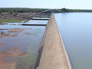
- Mzingwane DamMzingwane DamMzingwane Dam is a reservoir on the Mzingwane River, near Esigodini, Zimbabwe with a capacity of 42 Mm3. It supplies water to the City of Bulawayo...
, built in 1962, with a full supply capacity of 42 Mm3. It is located near the source of the river and supplies water to the City of BulawayoBulawayoBulawayo is the second largest city in Zimbabwe after the capital Harare, with an estimated population in 2010 of 2,000,000. It is located in Matabeleland, 439 km southwest of Harare, and is now treated as a separate provincial area from Matabeleland...
. - Zhovhe DamZhovhe DamZhovhe Dam is a reservoir on the Mzingwane River, Zimbabwe with a capacity of 133 Mm3. It supplies water for commercial irrigation and the town of Beitbridge....
, built in 1995, with a full supply capacity of 136 Mm3.It is located near the confluence with the Limpopo RiverLimpopo RiverThe Limpopo River rises in central southern Africa, and flows generally eastwards to the Indian Ocean. It is around long, with a drainage basin in size. Its mean annual discharge is 170 m³/s at its mouth...
and supplies water for irrigation and to BeitbridgeBeitbridgeBeitbridge or Mzingwane is a border town in the province of Matabeleland South, Zimbabwe. The name also refers to the border post and bridge spanning the Limpopo River, which forms the political border between South Africa and Zimbabwe.-Background:...
Additional dam sites have been identified at Glassblock
Glassblock Dam
Glassblock Dam is a proposed reservoir on the Mzingwane River, north of Gwanda, Zimbabwe with a capacity of 14 Mm3....
and Oakley Block
Oakley Block Dam
Oakley Block Dam is a proposed reservoir on the Mzingwane River, south of West Nicholson, Zimbabwe with a capacity of 41 Mm3....
, but development is not currently scheduled .
Currently, a project is underway to construct a pipeline from the upper Mtshabezi River
Mtshabezi River
The Mtshabezi River is a tributary of the Thuli River in southern Zimbabwe.- References :...
(not to be confused with Umchabezi River
Umchabezi River
The Umchabezi River is a tributary of the Mzingwane River in Beitbridge District and Gwanda District, Zimbabwe. The main dam on the river is Makado Dam, which supplies water for commercial irrigation.- References :...
) to Mzingwane Dam
Mzingwane Dam
Mzingwane Dam is a reservoir on the Mzingwane River, near Esigodini, Zimbabwe with a capacity of 42 Mm3. It supplies water to the City of Bulawayo...
.