

Muscoda, Wisconsin
Encyclopedia
Muscoda is a village in Grant
and Iowa
counties in the U.S. state
of Wisconsin
. The population was 1,453 at the 2000 census. The Grant County part of the village lies in the town of Muscoda
, while the Iowa County portion lies in the town of Pulaski, and is the largest village in the county, and third largest community.
. Lansing and his son were murdered in 1763 by their French assistants and the fame of the murder kept the name English Prairie alive until 1840.
The word Muscoda may be a corruption of the Ojibwa (Chippewa) word mashkode, meaning "prairie". The name was evidently taken from Longfellow's Hiawatha, in which it is mentioned several times:
and
This is most likely how Muscoda earned its name, from the popular meaning of "Prairie of Flowers."
Muscoda has billed itself as the "Wisconsin's Morel Capital" since 1982 and hosts the "Morel
Mushroom Festival" every year on the weekend following Mother's Day. The event includes carnival rides, tractors pulls, tournaments, merchant stands, food booths, and portable tattoo parlors.
According to the United States Census Bureau
, the village has a total area of 1.4 square miles (3.5 km²), all land.
of 2000, there were 1,453 people, 610 households, and 384 families residing in the village. The population density
was 1,069.1 people per square mile (412.5/km²). There were 661 housing units at an average density of 486.3 per square mile (187.7/km²). The racial makeup of the village was 98.42% White, 0.28% Black or African American
, 0.21% Native American, 0.07% Asian, and 1.03% from two or more races. Hispanic or Latino of any race were 1.31% of the population.
There were 610 households out of which 29.7% had children under the age of 18 living with them, 46.9% were married couples
living together, 11.0% had a female householder with no husband present, and 36.9% were non-families. 32.1% of all households were made up of individuals and 15.6% had someone living alone who was 65 years of age or older. The average household size was 2.30 and the average family size was 2.88.
In the village the population was spread out with 23.6% under the age of 18, 7.8% from 18 to 24, 27.3% from 25 to 44, 21.3% from 45 to 64, and 20.0% who were 65 years of age or older. The median age was 39 years. For every 100 females there were 94.0 males. For every 100 females age 18 and over, there were 88.8 males.
The median income for a household in the village was $30,903, and the median income for a family was $38,750. Males had a median income of $29,853 versus $21,058 for females. The per capita income
for the village was $15,390. About 7.9% of families and 10.2% of the population were below the poverty line, including 16.3% of those under age 18 and 9.3% of those age 65 or over.
 Riverdale High School
, which is part of the Riverdale School District, is in Muscoda.
Grant County, Wisconsin
Grant County is a county located in the U.S. state of Wisconsin. As of 2000, the population was 49,597. Its county seat is Lancaster. Estimates for 2008 show a population of 49,238...
and Iowa
Iowa County, Wisconsin
Iowa County is a county located in the U.S. state of Wisconsin. As of 2000, the population was 22,780. Its county seat and largest city is Dodgeville.Iowa County is part of the Madison Metropolitan Statistical Area.-Geography:According to the U.S...
counties in the U.S. state
U.S. state
A U.S. state is any one of the 50 federated states of the United States of America that share sovereignty with the federal government. Because of this shared sovereignty, an American is a citizen both of the federal entity and of his or her state of domicile. Four states use the official title of...
of Wisconsin
Wisconsin
Wisconsin is a U.S. state located in the north-central United States and is part of the Midwest. It is bordered by Minnesota to the west, Iowa to the southwest, Illinois to the south, Lake Michigan to the east, Michigan to the northeast, and Lake Superior to the north. Wisconsin's capital is...
. The population was 1,453 at the 2000 census. The Grant County part of the village lies in the town of Muscoda
Muscoda (town), Wisconsin
Muscoda is a town in Grant County, Wisconsin, United States. The population was 674 at the 2000 census. The Village of Muscoda is located partially within the town.-Geography:...
, while the Iowa County portion lies in the town of Pulaski, and is the largest village in the county, and third largest community.
History and culture
Muscoda was originally known as English Prairie, named for two English fur traders, Abraham Lansing and Garrit Roseboom, who opened a post at the close of the French and Indian WarFrench and Indian War
The French and Indian War is the common American name for the war between Great Britain and France in North America from 1754 to 1763. In 1756, the war erupted into the world-wide conflict known as the Seven Years' War and thus came to be regarded as the North American theater of that war...
. Lansing and his son were murdered in 1763 by their French assistants and the fame of the murder kept the name English Prairie alive until 1840.
The word Muscoda may be a corruption of the Ojibwa (Chippewa) word mashkode, meaning "prairie". The name was evidently taken from Longfellow's Hiawatha, in which it is mentioned several times:
"He had struck the deer and bison,
On the Muskoday, the meadow"
and
"On the Muskoday, the meadow,
On the prairie full of blossoms"
This is most likely how Muscoda earned its name, from the popular meaning of "Prairie of Flowers."
Muscoda has billed itself as the "Wisconsin's Morel Capital" since 1982 and hosts the "Morel
Morel
Morchella, the true morels, is a genus of edible mushrooms closely related to anatomically simpler cup fungi. These distinctive mushrooms appear honeycomb-like in that the upper portion is composed of a network of ridges with pits between them....
Mushroom Festival" every year on the weekend following Mother's Day. The event includes carnival rides, tractors pulls, tournaments, merchant stands, food booths, and portable tattoo parlors.
Geography
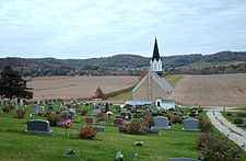
Muscoda is located at 43°11′18"N 90°26′26"W (43.188457, -90.440775), on the Wisconsin River. Large rolling hills board the south of the town covered in mixed hardwoods made up of mainly Maple, Red/White Oak, Aspen, Cherry, Elm, and Walnut. 2100 acres (8.5 km²) of public land hug both the east and west sides of Muscoda. These public lands hold a great deal of wildlife for sporstmen and wildlife enthusiast alike.According to the United States Census Bureau
United States Census Bureau
The United States Census Bureau is the government agency that is responsible for the United States Census. It also gathers other national demographic and economic data...
, the village has a total area of 1.4 square miles (3.5 km²), all land.
Demographics
As of the censusCensus
A census is the procedure of systematically acquiring and recording information about the members of a given population. It is a regularly occurring and official count of a particular population. The term is used mostly in connection with national population and housing censuses; other common...
of 2000, there were 1,453 people, 610 households, and 384 families residing in the village. The population density
Population density
Population density is a measurement of population per unit area or unit volume. It is frequently applied to living organisms, and particularly to humans...
was 1,069.1 people per square mile (412.5/km²). There were 661 housing units at an average density of 486.3 per square mile (187.7/km²). The racial makeup of the village was 98.42% White, 0.28% Black or African American
Race (United States Census)
Race and ethnicity in the United States Census, as defined by the Federal Office of Management and Budget and the United States Census Bureau, are self-identification data items in which residents choose the race or races with which they most closely identify, and indicate whether or not they are...
, 0.21% Native American, 0.07% Asian, and 1.03% from two or more races. Hispanic or Latino of any race were 1.31% of the population.
There were 610 households out of which 29.7% had children under the age of 18 living with them, 46.9% were married couples
Marriage
Marriage is a social union or legal contract between people that creates kinship. It is an institution in which interpersonal relationships, usually intimate and sexual, are acknowledged in a variety of ways, depending on the culture or subculture in which it is found...
living together, 11.0% had a female householder with no husband present, and 36.9% were non-families. 32.1% of all households were made up of individuals and 15.6% had someone living alone who was 65 years of age or older. The average household size was 2.30 and the average family size was 2.88.
In the village the population was spread out with 23.6% under the age of 18, 7.8% from 18 to 24, 27.3% from 25 to 44, 21.3% from 45 to 64, and 20.0% who were 65 years of age or older. The median age was 39 years. For every 100 females there were 94.0 males. For every 100 females age 18 and over, there were 88.8 males.
The median income for a household in the village was $30,903, and the median income for a family was $38,750. Males had a median income of $29,853 versus $21,058 for females. The per capita income
Per capita income
Per capita income or income per person is a measure of mean income within an economic aggregate, such as a country or city. It is calculated by taking a measure of all sources of income in the aggregate and dividing it by the total population...
for the village was $15,390. About 7.9% of families and 10.2% of the population were below the poverty line, including 16.3% of those under age 18 and 9.3% of those age 65 or over.
Education
Riverdale High School (Wisconsin)
Riverdale High School is the high school school for the Riverdale School District. It is located in Muscoda, Wisconsin.-External links:**...
, which is part of the Riverdale School District, is in Muscoda.
Business and industry
Muscoda is home of the Meister Cheese Company, which produces gourmet cheese.External links
- Muscoda, Wisconsin
- Muscoda, 1763-1856 Reprinted from the Wisconsin Magazine of History
- Muscoda Topographic Map, 1983 (7 MBMegabyteThe megabyte is a multiple of the unit byte for digital information storage or transmission with two different values depending on context: bytes generally for computer memory; and one million bytes generally for computer storage. The IEEE Standards Board has decided that "Mega will mean 1 000...
TIFF) From the U.S. Geological Survey (Symbol explanation)