

Muranga District
Encyclopedia
Districts of Kenya
The provinces of Kenya are subdivided into number of districts .- List of districts of Kenya :Following a High Court ruling in September 2009, there are 46 legal districts in Kenya :Coast Province:...
of Kenya
Kenya
Kenya , officially known as the Republic of Kenya, is a country in East Africa that lies on the equator, with the Indian Ocean to its south-east...
's Central Province
Central Province (Kenya)
Kenya's Central Province covers an area of 13,191 km² and is located to north of Nairobi and west of Mt. Kenya. The province had 4,383,743 inhabitants according to the 2009 census...
. Its capital town is also now named Murang'a
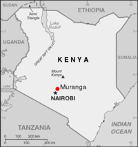
Murang'a
Murang'a is a town in Central Province of Kenya. The town was previously called Fort Hall. It is the administrative centre of Murang'a District and is mainly inhabited by the Kikuyu community....
but was called Fort Hall in colonial times (before 1963). It is inhabited mainly by and is considered the home of the Kikuyu, the largest community in Kenya. The district has a population of 942,581 (2009 census). Many have traveled to Murang'a to enjoy the lush folage. On the road to the Post Office the road forks leading travelor to take the road to Neri and beyond or the road to the Murang'a Technical College. As the travelor walks along the road, an old English pub sits along the road on the right. Over the course of several years Murang'a became the site for placement of a Peace Corps Volunteer (www.peacecorps.gov). It's peaceful beauty allow the travelor to wonder through it lush green folage.
History
When missionaries first came to Kenya, they were prevented from settling on the coast by the PortuguesePortugal
Portugal , officially the Portuguese Republic is a country situated in southwestern Europe on the Iberian Peninsula. Portugal is the westernmost country of Europe, and is bordered by the Atlantic Ocean to the West and South and by Spain to the North and East. The Atlantic archipelagos of the...
, who had taken the coastal area, strategic for trade, from Arab powers in the 16th century. The missionaries were forced to venture into Kenya's rugged interior, and Murang'a was one of the first places they settled.
When the British set up the East African Protectorate in 1895, their first administrative post, Fort Smith, was located in Murang'a.
One on the main highlights of Murang'a's history, however, is that the Mau Mau uprising
Mau Mau Uprising
The Mau Mau Uprising was a military conflict that took place in Kenya between 1952 and 1960...
was led by the Kikuyu community and the Kikuyu consider Murang'a their ancestral origin. Murang'a is considered by some as the birthplace of the Kenyan independence movement.
District subdivisions
| Local authorities (councils) | |||
| Authority | Type | Population* | Urban pop.* |
|---|---|---|---|
| Muranga | Municipality | 24,443 | 11,021 |
| Kangema | Town | 18,229 | 3,971 |
| Muranga County | County | 305,632 | 0 |
| Total | - | 348,304 | 14,992 |
| Administrative divisions | |||
| Division | Population* | Urban pop.* | Headquarters |
|---|---|---|---|
| Kiharu | 84,868 | 10,433 | Muranga |
| Kahuro | 92,104 | 0 | |
| Kangema | 61,182 | 785 | |
| Mathioya | 110,139 | 0 | |
| Total | 348,304 | 11,218 | - |
The district has three constituencies:
- Kangema ConstituencyKangema ConstituencyKangema Constituency encompasses Kangema township which is the headquarter of the newly created Murang'a North District. Murang'a North is a heavily populated district of the Central Province and it covers a vast portion of the Aberdare Ranges. The economic mainstay for Kangema is agriculture,...
- Kiharu ConstituencyKiharu ConstituencyKiharu Constituency is an electoral constituency in Kenya. It is one of three constituencies of Muranga District. The Muranga town is located within this constituency...
- Mathioya ConstituencyMathioya ConstituencyMathioya Constituency is an electoral constituency in Kenya. It is one of three constituencies of Muranga District. The constituency has four wards comprising Kiharu, Kahuro, Kangema, and Mathioya all electing councillors to the Muranga County council....