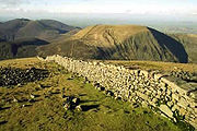
Mourne Wall
Encyclopedia

Wall
A wall is a usually solid structure that defines and sometimes protects an area. Most commonly, a wall delineates a building and supports its superstructure, separates space in buildings into rooms, or protects or delineates a space in the open air...
that was constructed to enclose a reservoir's catchment area in the Mourne Mountains, Northern Ireland
Northern Ireland
Northern Ireland is one of the four countries of the United Kingdom. Situated in the north-east of the island of Ireland, it shares a border with the Republic of Ireland to the south and west...
. It was built between 1904 and 1922 by the Belfast Water Commissioners to enclose the water catchment in the Mournes.
The wall was crafted from natural granite
Granite
Granite is a common and widely occurring type of intrusive, felsic, igneous rock. Granite usually has a medium- to coarse-grained texture. Occasionally some individual crystals are larger than the groundmass, in which case the texture is known as porphyritic. A granitic rock with a porphyritic...
stone using traditional dry stone walling techniques. On average the wall is about 1.5 metres (4.9 ft) high and 0.8 to 0.9 m (2.6 to 3 ) thick. It is 22 miles (35.4 km) long and passes over fifteen mountains (listed clockwise from the Kilkeel River):
- Slievenaglogh 445 m (1,460 ft)
- Slieve MuckSlieve MuckSlieve Muck is one of the Mourne Mountains in County Down, Northern Ireland. It has a height of 674 metres . Its summit overlooks Spelga Dam and the Deer's Meadow, the source of the River Bann....
674 m (2,211.3 ft) - Carn Mountain 587 m (1,925.9 ft)
- Slieve Loughshannagh 619 m (2,030.8 ft)
- Slieve Meelbeg 708 m (2,322.8 ft)
- Slieve Meelmore 684 m (2,244.1 ft)
- Slieve BearnaghSlieve BearnaghSlieve Bearnagh is a mountain in the Mourne Mountains, Northern Ireland. Its summit is crowned by a number of rocky tors. The Mourne Wall crosses the summit of Slieve Bearnagh east to west. Paths lead to the cols on either side of the mountain, namely Pollaphuca to the west and Hare's Gap to the...
727 m (2,385.2 ft) - Slievenaglogh 586 m (1,922.6 ft)
- Slieve Corragh 691 m (2,267.1 ft)
- Slieve CommedaghSlieve CommedaghSlieve Commedagh is a 767 m mountain in County Down, Northern Ireland. It is the second-highest of the Mourne Mountains, after Slieve Donard, and the second-highest mountain in Northern Ireland....
765 m (2,509.8 ft) - Slieve DonardSlieve DonardSlieve Donard is a 850 m mountain in County Down, Northern Ireland. It is part of the Mourne Mountains and the highest peak in Northern Ireland and in the wider province of Ulster. It is the 19th highest peak on the island of Ireland...
850 m (2,788.7 ft) - Rocky Mountain 525 m (1,722.4 ft)*
- Slieve BinnianSlieve BinnianSlieve Binnian is the third highest mountain in Northern Ireland at . The name comes from the rocky tors situated around the top of the mountain. These very rugged crest of rocky tors makes it easy to identify in views around the Mourne Mountains....
747 m (2,450.8 ft) - Wee Binnian 460 m (1,509.2 ft)
- Moolieve 332 m (1,089.2 ft)
The wall took eighteen years to complete. The Silent Valley Reservoir
Silent Valley Reservoir
The Silent Valley Reservoir is a reservoir located in the Mourne Mountains near Kilkeel, County Down in Northern Ireland. It supplies most of the water for County Down, surrounding counties and most of Belfast. It is owned and maintained by Northern Ireland Water Limited...
was created to hold the water in the catchment area, and supply Belfast
Belfast
Belfast is the capital of and largest city in Northern Ireland. By population, it is the 14th biggest city in the United Kingdom and second biggest on the island of Ireland . It is the seat of the devolved government and legislative Northern Ireland Assembly...
with water. Some people argue that the wall was quite useless as it fences off about 9000 acres (36.4 km²) of barren and desolate mountains. However, it brought a lot of very welcome employment
Employment
Employment is a contract between two parties, one being the employer and the other being the employee. An employee may be defined as:- Employee :...
at the time, and the main purpose of enclosing the area was to isolate the catchment area from the effects of cattle and sheep on the water course. It is currently owned and maintained by Northern Ireland Water.

