
.gif)
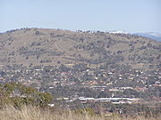
Mount Taylor (Australian Capital Territory)
Encyclopedia
Woden Valley
Woden Valley is a district of Canberra, the capital city of Australia. Its name is taken from the name of a nearby homestead owned by Dr James Murray who named the homestead after the Old English god Woden in October 1837. He named it this as he was to spend his life in the pursuit of wisdom and...
, Weston Creek district
Weston Creek
Weston Creek is a residential district of Canberra, Australian Capital Territory, Australia, situated to the west of the Woden Valley district and approximately 13 km southwest of the Canberra city centre...
and Tuggeranong Valley
Tuggeranong
Tuggeranong is the southernmost town centre of Canberra, the capital city of Australia. It comprises 19 suburbs with a total of 31,819 dwellings, housing 87,119 people of the 324,034 people in the Australian Capital Territory . The district occupies 117 square kilometres to the east of the...
, in Canberra
Canberra
Canberra is the capital city of Australia. With a population of over 345,000, it is Australia's largest inland city and the eighth-largest city overall. The city is located at the northern end of the Australian Capital Territory , south-west of Sydney, and north-east of Melbourne...
, Australia
Australia
Australia , officially the Commonwealth of Australia, is a country in the Southern Hemisphere comprising the mainland of the Australian continent, the island of Tasmania, and numerous smaller islands in the Indian and Pacific Oceans. It is the world's sixth-largest country by total area...
. Mount Taylor is part of the Canberra Nature Park
Canberra Nature Park
The Canberra Nature Park is actually 30 separate protected areas in Canberra, Australian Capital Territory, ranging from bushland hills to lowland native grassland...
. The hill is 856 metres above sea level. It is surrounded by the suburbs of Kambah
Kambah, Australian Capital Territory
Kambah is the northernmost suburb in the district of Tuggeranong, Canberra. It is located just south of the Mount Taylor in the Canberra Nature Park. It is located north of the suburbs of Greenway and Wanniassa...
, Fisher
Fisher, Australian Capital Territory
Fisher is a suburb of Canberra, Australian Capital Territory, Australia located in the district of Weston Creek. Fisher was named after Andrew Fisher , coal miner, founding member of the federal parliamentary Labor Party and Prime Minister of Australia for three terms between 1908 and 1915...
, Waramanga
Waramanga, Australian Capital Territory
Waramanga is a suburb of Canberra, Australian Capital Territory, Australia located in the district of Weston Creek.Waramanga was established in the late 1960s and was named after the Aboriginal tribe of Central Australia, also known as the Warumungu people.-History:The Weston Creek district was...
, Chifley
Chifley, Australian Capital Territory
Chifley is a suburb of Canberra, Australia in the district of Woden Valley.It was named after Joseph Benedict Chifley, Prime Minister of Australia from July 1945 to December 1949. The streets of Chifley are named for Scientists and Educationalists...
, Pearce
Pearce, Australian Capital Territory
Pearce is a suburb in the Canberra, Australia district of Woden. The postcode is 2607. It was named after the longest-serving Senator and longest-serving Minister in Australia's federal history, Sir George Pearce....
, and Torrens
Torrens, Australian Capital Territory
Torrens is a suburb in the Woden Valley district of Canberra, Australia. It is located along the district's southern edge. The suburb is named after Sir Robert Torrens, a former Premier of South Australia. The suburb was gazetted on 12 May 1966. Streets in Torrens are named after South Australian...
. There are walking tracks to the peak but no road access.
History
Mount Taylor was named after James Taylor, an early squatter in the district prior to 1829. An early map entitled Survey of part of the Morombidgee and Country South of Lake George by Surveyor White shows Taylor's huts close to the site of Yarralumla homestead. Taylor was a son-in-law of Colonel George Johnston who commanded the New South WalesNew South Wales
New South Wales is a state of :Australia, located in the east of the country. It is bordered by Queensland, Victoria and South Australia to the north, south and west respectively. To the east, the state is bordered by the Tasman Sea, which forms part of the Pacific Ocean. New South Wales...
Corps, which deposed Governor William Bligh during the Rum Rebellion
Rum Rebellion
The Rum Rebellion of 1808 was the only successful armed takeover of government in Australia's history. The Governor of New South Wales, William Bligh, was deposed by the New South Wales Corps under the command of Major George Johnston, working closely with John Macarthur, on 26 January 1808, 20...
of 1808.
Wildlife

A Mount Taylor park care group was established in 1989. It assists in weed removal, monitors the bird population and provides guides to the reserve. Over 85 species of birds have been identified on the hill and nearby.
Geology and geography
Mount Taylor is elongated in the north–northwest direction. This is parallel with the general direction of the Murumbidgee River. A ridge extends northwards to Oakey Hill. This separates the Woden Valley from Weston Creek. Another ridge extends from the south east and curves around to the east forming Farrer Ridge. Drainage from the east goes into Yarralumla Creek in the Woden Valley. On the west and south side runoff goes into Village Creek in Kambah.The rocks on Mount Taylor are from the Silurian
Silurian
The Silurian is a geologic period and system that extends from the end of the Ordovician Period, about 443.7 ± 1.5 Mya , to the beginning of the Devonian Period, about 416.0 ± 2.8 Mya . As with other geologic periods, the rock beds that define the period's start and end are well identified, but the...
age from 420 million years ago. They are acid volcanic rocks. On the top and western sides is a rock called ignimbrite
Ignimbrite
An ignimbrite is the deposit of a pyroclastic density current, or pyroclastic flow, a hot suspension of particles and gases that flows rapidly from a volcano, driven by a greater density than the surrounding atmosphere....
. This was formed by massive volcanic explosions that ejected hot volcanic particles in the air that then fell to the ground. This collection of rocks is known as the Laidlaw Volcanics. On the northern slopes and lower eastern slopes the rock is rhyodacite
Rhyodacite
Rhyodacite is an extrusive volcanic rock intermediate in composition between dacite and rhyolite. It is the extrusive equivalent of granodiorite. Phenocrysts of sodium rich plagioclase, sanidine, quartz, and biotite or hornblende are typically set in an aphanitic to glassy light to intermediate...
. This is from the Deakin Volcanics. There is also a sill of porphyry
Porphyry (geology)
Porphyry is a variety of igneous rock consisting of large-grained crystals, such as feldspar or quartz, dispersed in a fine-grained feldspathic matrix or groundmass. The larger crystals are called phenocrysts...
intruded into the volcanic rocks on the east and south slopes. The rocks dip to the south west at an angle of 20°. This dip is perpendicular to the long extension of the mountain, showing that it is the strata in the rock that has determined the shape of the mountain.
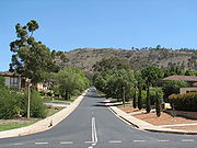
Human changes
The Tuggeranong Parkway forms a boundary to the nature park in the northwest. Sulwood Drive forms the southwest and southern boundary of the park. In the east, houses have backyards backing onto the park in Torrens, Pearce, and Chifley. Waldock Street provides access to the north end of the mount.Major high voltage power lines run around the west and south of the hill connecting the Lyons and Wanniassa substations. There is a horse riding trail along the back of Woden Valley, connecting to the horse holding paddock on the southeast ridge of Mount Taylor. There are several water supply reservoirs on the hill behind the suburbs.