

Canberra Nature Park
Encyclopedia
Canberra
Canberra is the capital city of Australia. With a population of over 345,000, it is Australia's largest inland city and the eighth-largest city overall. The city is located at the northern end of the Australian Capital Territory , south-west of Sydney, and north-east of Melbourne...
, Australian Capital Territory
Australian Capital Territory
The Australian Capital Territory, often abbreviated ACT, is the capital territory of the Commonwealth of Australia and is the smallest self-governing internal territory...
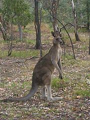
, ranging from bushland
Bushland
Bushland is any area in Australia that is predominantly indigenous flora and fauna.Bushland is the term commonly used by conservation protection groups and other environmental groups as a blanket term for natural vegetation, which may cover any kind of habitat from open shrubby country with few...
hills to lowland native grassland. Many of the areas have previously been cleared for grazing
Grazing
Grazing generally describes a type of feeding, in which a herbivore feeds on plants , and also on other multicellular autotrophs...
, but many are now returning to native bushland through revegetation and rehabilitation programs.
Canberra's inner hills Black Mountain
Black Mountain (Australian Capital Territory)
Black Mountain is situated close to the central business district of Australia's capital city Canberra. Like all major hills in Canberra it is protected from development by the Canberra Nature Park. It is covered in native bushland and is a haven to native wildlife.With its peak at 811.987m AHD,...
, Mount Ainslie
Mount Ainslie (Australian Capital Territory)
Mount Ainslie or Mount Ainslie-Majura is a part of Canberra Nature Park. It borders on the inner suburbs of Campbell, Ainslie and Hackett...
, Mount Majura
Mount Majura
Mount Majura, is a small mountain located in Canberra, Australia. Mount Majura lies close to the more prominent Mount Ainslie and at 888 metres is the highest point in Canberra...
, Mount Pleasant, Russell Hill, Red Hill
Red Hill, Australian Capital Territory
Red Hill is a suburb of Canberra, Australian Capital Territory, Australia. The suburb is named after the northernmost hill of the ridge to the west of the suburb. The ridge is a reserve and managed as part of the Canberra Nature Park. The hill is an element of the central Canberra design...
, Mount Mugga, O'Connor Ridge, Bruce Ridge, Aranda Bushland, Mount Painter, The Pinnacle, Lyneham Ridge, Oakey Hill, Mount Taylor, Isaacs Ridge, Mount Stromlo, Mount Arawang, Neighbour Hill, Wanniassa Hill, and Narrabundah Hill are protected from development by the National Capital Plan and almost all are now part of the Canberra Nature Park system. These hills provide a scenic backdrop and natural setting for Canberra's urban areas, as originally set out in the Walter Burley Griffin
Walter Burley Griffin
Walter Burley Griffin was an American architect and landscape architect, who is best known for his role in designing Canberra, Australia's capital city...
Plan.
Most people in Canberra live within easy walking distance of a Canberra Nature Park area.
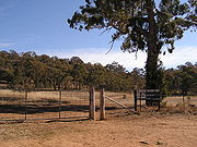
The areas are typically enclosed by simple wire fences, or by house fences. Gates are provided for people to walk or run in the parks; motorbikes are excluded. Some parks with mountains have reservoirs, as part of ACT Electricity and Water's
ACTEW Corporation
ACTEW Corporation Limited is a government-owned company with assets and investments in water, wastewater, electricity, gas and telecommunications. ACTEW is wholly owned by the ACT Government...
supply network
Water supply network
A water supply system or water supply network is a system of engineered hydrologic and hydraulic components which provide water supply. A water supply system typically includes:# A drainage basin ;...
.
| Park | Vegetation | Area (km²) | Park | Vegetation | Area (km²) |
|---|---|---|---|---|---|
| Aranda Bushland | Forest | 1.06 | Black Mountain | Forest | 4.52 |
| Bruce Ridge | Forest | 1.34 | Cooleman Ridge | Woodland | 1.89 |
| Crace Grassland Reserve | Grassland | 1.21 | Dunlop Dunlop, Australian Capital Territory Dunlop is a suburb of Belconnen, Australian Capital Territory, Australia. Dunlop is located at the far north-west edge of Canberra, nearby the border with the state of New South Wales. Located approximately 11.6 kilometers north-west of the city, Dunlop is situated next to the suburbs of Fraser,... Grassland Reserve |
Grassland | 1.06 |
| Farrer Ridge | Woodland | 1.78 | Goorooyarroo | Woodland | 7.01 |
| Gossan Hill | Forest | 0.48 | Gungaderra Grassland Reserve | Grassland | 2.70 |
| Isaacs Ridge Reserve | Forest/Woodland | 0.34 | Jerrabomberra Wetland Reserve | Wetland | 2.08 |
| McQuoids Hill | Woodland | 0.56 | Mount Ainslie | Forest/woodland | |
| Mount Majura Mount Majura Mount Majura, is a small mountain located in Canberra, Australia. Mount Majura lies close to the more prominent Mount Ainslie and at 888 metres is the highest point in Canberra... |
Woodland | Mount Mugga Mugga | Woodland | 1.05 | |
| Mount Painter Reserve | Woodland | 0.86 | Mount Pleasant | Woodland | 0.50 |
| Mount Taylor | Woodland | 2.93 | Mulanggari Grassland Reserve | Grassland | 1.17 |
| Mulligans Flat Reserve | Woodland | 7.81 | O'Connor Ridge | Forest | 0.62 |
| Oakey Hill Reserve | Woodland | 0.66 | Percival Hill Reserve | Forest | 0.63 |
| Red Hill Red Hill, Australian Capital Territory Red Hill is a suburb of Canberra, Australian Capital Territory, Australia. The suburb is named after the northernmost hill of the ridge to the west of the suburb. The ridge is a reserve and managed as part of the Canberra Nature Park. The hill is an element of the central Canberra design... |
Woodland | 2.87 | Rob Roy | Forest | 19.77 |
| The Pinnacle Reserve | Woodland | 1.38 | Tuggeranong Hill Tuggeranong Hill Tuggeranong Hill is located in Tuggeranong, Canberra. It is sometimes referred to as Mount Tuggeranong due to its prominence.Lanyon Valley is almost completely surrounded by hills and mountains and consequently television transmissions from Black Mountain are affected. To overcome this, there is a... |
Woodland | 3.17 |
| Urambi Hills | Woodland | 2.43 | Wannissa Hills | Woodland | 2.27 |
External links
- Canberra Nature Park - Territory and Municipal Services
- Park Maps - Territory and Municipal Services