

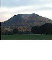
Mount Napier
Encyclopedia
Victoria (Australia)
Victoria is the second most populous state in Australia. Geographically the smallest mainland state, Victoria is bordered by New South Wales, South Australia, and Tasmania on Boundary Islet to the north, west and south respectively....
, Australia
Australia
Australia , officially the Commonwealth of Australia, is a country in the Southern Hemisphere comprising the mainland of the Australian continent, the island of Tasmania, and numerous smaller islands in the Indian and Pacific Oceans. It is the world's sixth-largest country by total area...
, one of the youngest volcano
Volcano
2. Bedrock3. Conduit 4. Base5. Sill6. Dike7. Layers of ash emitted by the volcano8. Flank| 9. Layers of lava emitted by the volcano10. Throat11. Parasitic cone12. Lava flow13. Vent14. Crater15...
es in Australia, last erupted about 5,290 BCE. Mount Napier State Park
Mount Napier State Park
Mount Napier State Park is a state park in the Australian state of Victoria. It is 20 km northeast of Mount Eccles; its centerpiece is Mount Napier, a true volcanic cone. The park was established in 1987, and today encompasses 2800 hectares of land....
is located 270 kilometres west of Melbourne
Melbourne
Melbourne is the capital and most populous city in the state of Victoria, and the second most populous city in Australia. The Melbourne City Centre is the hub of the greater metropolitan area and the Census statistical division—of which "Melbourne" is the common name. As of June 2009, the greater...
and 17 km south of Hamilton
Hamilton, Victoria
Hamilton is a city in western Victoria, Australia. It is located at the intersection of the Glenelg Highway and the Henty Highway...
. The Mount Napier Lava Flow reached nearby Mount Eccles
Mount Eccles
Mount Eccles is an inactive volcano in southwestern Victoria, Australia near Macarthur. It is composed of scoria hill from a series of volcanic vents. The Gunditjmara name for the mountain is Budj Bim meaning High Head...
which is 25 km south-west of Mount Napier flowing along Harmans Valley just south of Byaduk North
Byaduk, Victoria
Byaduk is a township in the Shire of Southern Grampians in the Western District of Victoria, Australia.European settlement began around 1853 by Wendish or SorbianLutheran immigrants who gave it the name Neukirch after the town in Saxony....
. The flow also created lava blisters or tumuli along the flow, creating mounds of basalt rocks. The blisters are unique in Australia and a rare occurrence in the rest of the world. They are formed by gas and heat from the lava pushing up against the crust. Several caves and lava tubes can also be found at Byaduk
Byaduk, Victoria
Byaduk is a township in the Shire of Southern Grampians in the Western District of Victoria, Australia.European settlement began around 1853 by Wendish or SorbianLutheran immigrants who gave it the name Neukirch after the town in Saxony....
.
Mount Napier has a composite lava shield with a superimposed scoria cone. The cone rises 500 feet (150 m) above the surrounding plain
Plain
In geography, a plain is land with relatively low relief, that is flat or gently rolling. Prairies and steppes are types of plains, and the archetype for a plain is often thought of as a grassland, but plains in their natural state may also be covered in shrublands, woodland and forest, or...
s to an elevation of 1,440 feet (440 m), making it the highest point on the Western District Plains of Victoria. Mount Napier is part of the Newer Volcanics Province
Newer Volcanics Province
The Newer Volcanics Province is a complex of volcanic centres formed by the East Australia hotspot across south-eastern Australia. It has an area of 6,000 square miles with over 400 vents and contains the youngest volcanoes in Australia...
, which is the youngest volcanic centre in Australia. The Newer Volcanics Province covers an area of 6,000 square miles ( 15,000 square km) and contains over 400 vents.