

Mount Morris Dam
Encyclopedia
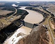
The Mount Morris Dam is a concrete dam
Dam
A dam is a barrier that impounds water or underground streams. Dams generally serve the primary purpose of retaining water, while other structures such as floodgates or levees are used to manage or prevent water flow into specific land regions. Hydropower and pumped-storage hydroelectricity are...
on the Genesee River
Genesee River
The Genesee River is a North American river flowing northward through the Twin Tiers of Pennsylvania and New York. The river provided the original power for the Rochester area's 19th century mills and still provides hydroelectric power for downtown Rochester....
. It is located south of Rochester, New York
Rochester, New York
Rochester is a city in Monroe County, New York, south of Lake Ontario in the United States. Known as The World's Image Centre, it was also once known as The Flour City, and more recently as The Flower City...
in the towns of Leicester
Leicester (town), New York
Leicester is a town in Livingston County, New York, United States. The population was 2,287 at the 2000 census. The town is named after Leicester Phelps, an early inhabitant....
and Mount Morris
Mount Morris (town), New York
Mount Morris is a town in Livingston County, New York, United States. The population was 4,567 at the 2000 census. The town and village were named after Robert Morris, the financier of the American Revolution....
in Livingston County, New York
Livingston County, New York
As of the census of 2000, there were 64,328 people, 22,150 households, and 15,349 families residing in the county. The population density was 102 people per square mile . There were 24,023 housing units at an average density of 38 per square mile...
, next to Letchworth State Park
Letchworth State Park
Letchworth State Park is a New York state park located 35 miles southwest of Rochester and 60 miles southeast of Buffalo in Livingston and Wyoming counties. The park is roughly 17 miles long, covering of land along the Genesee River...
.
History
The Mt. Morris Dam was built between 1948 and 1952 by the BuffaloBuffalo, New York
Buffalo is the second most populous city in the state of New York, after New York City. Located in Western New York on the eastern shores of Lake Erie and at the head of the Niagara River across from Fort Erie, Ontario, Buffalo is the seat of Erie County and the principal city of the...
District office of the U.S. Army Corps of Engineers (USACE). The project was authorized by the United States Congress
United States Congress
The United States Congress is the bicameral legislature of the federal government of the United States, consisting of the Senate and the House of Representatives. The Congress meets in the United States Capitol in Washington, D.C....
in the Flood Control Act of 1944
Flood Control Act of 1944
The Pick-Sloan Flood Control Act of 1944 , enacted in the 2nd session of the 78th Congress, is U.S. legislation that authorized the construction of numerous dams and modifications to previously existing dams, as well as levees across the United States...
at a cost of $25 million.
Records show that the Genesee River Valley
Genesee River
The Genesee River is a North American river flowing northward through the Twin Tiers of Pennsylvania and New York. The river provided the original power for the Rochester area's 19th century mills and still provides hydroelectric power for downtown Rochester....
and the City of Rochester
Rochester, New York
Rochester is a city in Monroe County, New York, south of Lake Ontario in the United States. Known as The World's Image Centre, it was also once known as The Flour City, and more recently as The Flower City...
had experienced flooding since 1800. The flood of 1865, which developed flows exceeding 24 million gallons per minute, resulted in massive destructions with flows equating half the flows of Niagara Falls
Niagara Falls
The Niagara Falls, located on the Niagara River draining Lake Erie into Lake Ontario, is the collective name for the Horseshoe Falls and the adjacent American Falls along with the comparatively small Bridal Veil Falls, which combined form the highest flow rate of any waterfalls in the world and has...
. Severe floods occurred every seven years between 1865 and 1950.
The USACE states that, in the years since the completion of the dam, an estimated $1 billion in flooding damages have been prevented, and that during Hurricane Agnes
Hurricane Agnes
Hurricane Agnes was the first tropical storm and first hurricane of the 1972 Atlantic hurricane season. A rare June hurricane, it made landfall on the Florida Panhandle before moving northeastward and ravaging the Mid-Atlantic region as a tropical storm...
in 1972, $210 million in damages was prevented, primarily to the city of Rochester
Rochester, New York
Rochester is a city in Monroe County, New York, south of Lake Ontario in the United States. Known as The World's Image Centre, it was also once known as The Flour City, and more recently as The Flower City...
. The water inflow due to Hurricane Agnes exceeded the storage capacity of the reservoir and it was necessary to release water through the gates of the dam, causing minor downstream flooding. These releases were made to prevent overtopping of the spillway. Had the spillway overtopped, accumulated debris in the reservoir would have passed downstream, causing log jams and additional damage. Inflows of this magnitude are only expected to happen an average of every 300 years.
Commemorations
June 2002 commemorated the 50th anniversary of the completion of Mount Morris Dam. A celebration and dedication of the commemorative kiosk was held to honor and recognize the men and women employed by the U.S. Army Corps of Engineers, Buffalo District and Mount Morris Dam Builders, 1948-1952. The kiosk rests on a foundation of bricks, each of which is inscribed with the name and occupation of the builders.Visiting Centers
The William B. Hoyt II Visitor Center at Mount Morris Dam, opened by the U.S. Army Corps of Engineers in 1999, was built to accommodate the thousands of people who visit the dam each year. This 5400 square feet (501.7 m²) center features a large atrium, museum, theater and public restroom facilities, and provides a relaxing, educational experience to visitors.Project Facts
GeneralMiles above mouth of Genesee River: 67
Drainage area above dam: 1075 sq mi (2,784.2 km²).
Drainage area below dam: 1391 sq mi (3,602.7 km²).
Dam
Type: Concrete Gravity/Dry
Total length: 1028 ft (313.3 m)
Top width: 20 ft (6.1 m)
Maximum height above riverbed: 230 ft (70.1 m)
Top elevation: 790 ft (240.8 m) above sea level
Spillway
Total length: 550 ft (167.6 m)
Crest elevation: 760 ft (231.6 m)
Reservoir
Length in River Miles: 17 miles (27.4 km) at Max. flood control pool
Water Surface Elevation: 760 ft (231.6 m) above sea level at Max. flood control pool
Storage Volume: 301853 acre.ft at Max. flood control pool
Outlet Works
Type: Rectangular conduits
Location: Base of spillway
Real-time Genesee River data may be obtained at: http://www.erh.noaa.gov/er/nerfc