

Moselotte
Encyclopedia
The Moselotte is a river
in Lorraine
, in the French
department of Vosges. It is a direct right tributary of the Moselle
, and thus a sub-tributary of the Rhine.
. Its length is 47 km, while its watershed
is 356 km².
, Cornimont
, Saulxures
, Thiéfosse
, Vagney
, Saint-Amé
, Le Syndicat
, Dommartin-lès-Remiremont
and Saint-Étienne-lès-Remiremont
opposite the town of Remiremont.
, including lac de Blanchemer
, lac de Lispach
and lac des Corbeaux
.
The presence of a high barrage at the foot of Kastelberg since 1983 has resulted in the appearance of the lac de la Lande. It collects water from several sources via conduits, and supplies the La Bresse commune with its energy.
At the entry downstream of Saulxures
, a lake of 9.6 hectares was set up in 1998 under the name lac de la Moselotte which hosts a leisure center.
at a place called Zainvilliers, which is situated upstream of the Moselotte's confluence with the Moselle. The river's watershed
at this point is 187 km² or 53% of its entire watershed, corresponding to the upper half of its course.
The average interannual flow rate, or discharge
at Vagney is 8.54 m³/s.
The Moselotte exhibits quite marked seasonal fluctuations, with a winter-spring period of high water whose monthly average flow rate is between 10.8 and 13.2 m³/s from November to April inclusive, with a maximum in December. From the beginning of May, the flow rate falls off rapidly, reaching 3.06 m³/s in August, which is not very severe for a body of water of this size. However year by year fluctuation can be more significant, as can those in the short term.
Average monthly flow rate of the Moselotte (m³/s) measured at Vagney hydrological station
Data taken over a 40 year period
At low water, the 3-year low instantaneous flow rate can drop to 0.37 m³/s in the case of a dry five-year period, or about 370 litres per second, which is quite severe, but typical of rivers in the Moselle basin.
Floods can also be significant particularly bearing in mind the smallness of the watershed (only 187 km²). The maximum instantaneous flow rates over a 2-year and 5-year period (MIFR2 and MIFR5) measure 97 and 110 m³/s respectively. The MIFR10 is 120 m³/s, the MIFR20 is 130 m³/s, while the MIFR50 rises to 150 m³/s/
The maximum instantaneous flow rate recorded at Vagney was 121 m³/s on 15 February 1990, while the maximum daily average flow rate was 108 m³/s on the same day. Comparing these values to the MIFR measurements for the river suggests that the flood on that day was approximately a 10-year event and thus likely to recur frequently.
Overall the Moselotte is an extremely abundant river in its upper course. The runoff curve number in this 53% of its watershed is 1,445 mm annually, which is extremely high for the northern part of France, and more than four times higher than the French national average. It is also three times higher than the average over the French basin of the Moselle. The specific flow rate attaches to these facts the portentous figure of 45.7 litres per second per square kilometre of watershed.
, located slightly downstream of the town of Metz
, near where it leaves French territory, rises to 445 mm. The specific flow rate of the Moselotte rises to 38.5 litres per second per square kilometre of watershed. This, along with the Breuchin (a tributary of the Lanterne
and sub-tributary of the Saône
which flows elsewhere in the same region) constitutes a record for the north third of France.
The Moselotte is clearly more abundant than the Moselle at their confluence (13.7 m³/s against 9.3 m³/s ).
, at 6.5 mg/l in 2006, was still classified "bonne". The ammonium ion level was measured at 0.09 mg/l, which was classed as "excellent".
, the river has given rise to a significant breakthrough in fish farming
, namely the invention of artificial reproduction by Joseph Remy and Antoine Géhin in the 19th century
. The Moselotte basin also has the highest density in the world in small hydroelectric barrages
, which serve the watermill
s, sawmill
s, spinning
and weaving
houses along the river and its tributaries.
A railway line once ran along the Moselotte valley between Remiremont and Cornimont. Today it has been transformed into a voie verte (green route) and replaced with bus service provided by TER Lorraine
(line 9), extended to La Bresse.
River
A river is a natural watercourse, usually freshwater, flowing towards an ocean, a lake, a sea, or another river. In a few cases, a river simply flows into the ground or dries up completely before reaching another body of water. Small rivers may also be called by several other names, including...
in Lorraine
Lorraine (région)
Lorraine is one of the 27 régions of France. The administrative region has two cities of equal importance, Metz and Nancy. Metz is considered to be the official capital since that is where the regional parliament is situated...
, in the French
France
The French Republic , The French Republic , The French Republic , (commonly known as France , is a unitary semi-presidential republic in Western Europe with several overseas territories and islands located on other continents and in the Indian, Pacific, and Atlantic oceans. Metropolitan France...
department of Vosges. It is a direct right tributary of the Moselle
Moselle
Moselle is a department in the east of France named after the river Moselle.- History :Moselle is one of the original 83 departments created during the French Revolution on March 4, 1790...
, and thus a sub-tributary of the Rhine.
Geography
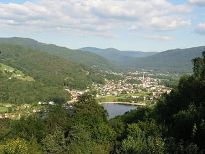
The Moselotte rises in the massif des Vosges at the fontaine de la Duchesse, near the summit of Hohneck. It flows into the Moselle at RemiremontRemiremont
Remiremont is a commune in the Vosges department in Lorraine in northeastern France.Inhabitants are called Romarimontains.-Geography:Remiremont is located on the Moselle, close to its confluence with the Moselotte, southeast of Épinal...
. Its length is 47 km, while its watershed
Drainage basin
A drainage basin is an extent or an area of land where surface water from rain and melting snow or ice converges to a single point, usually the exit of the basin, where the waters join another waterbody, such as a river, lake, reservoir, estuary, wetland, sea, or ocean...
is 356 km².
Communes traversed by the Moselotte
The Moselotte flows through, from upstream to downstream, the communes of La BresseLa Bresse
La Bresse is a commune in the Vosges department in Lorraine in northeastern France.-External links:...
, Cornimont
Cornimont
Cornimont is a commune in the Vosges department in Lorraine in northeastern France.-External links:*...
, Saulxures
Saulxures-sur-Moselotte
Saulxures-sur-Moselotte is a commune in the Vosges department in Lorraine in northeastern France.It is situated between Remiremont and La Bresse, just off the D43 road, within the Parc Naturel Régional des Ballons....
, Thiéfosse
Thiéfosse
Thiéfosse is a commune in the Vosges department in Lorraine in northeastern France.-References:*...
, Vagney
Vagney
Vagney is a commune in the Vosges department in Lorraine in northeastern France....
, Saint-Amé
Saint-Amé
Saint-Amé is a commune in the Vosges department in Lorraine in northeastern France.-References:*...
, Le Syndicat
Le Syndicat
Le Syndicat is a commune in the Vosges department in Lorraine in northeastern France.-References:*...
, Dommartin-lès-Remiremont
Dommartin-lès-Remiremont
Dommartin-lès-Remiremont is a commune in the Vosges department in Lorraine in northeastern France.-External links:*...
and Saint-Étienne-lès-Remiremont
Saint-Étienne-lès-Remiremont
Saint-Étienne-lès-Remiremont is a commune in the Vosges department in Lorraine in northeastern France.-External links:* *...
opposite the town of Remiremont.
Main tributaries
The Moselotte is fed by the following tributaries:
|
Xoulces The Xoulces is a small but abundant river in France which flows in Lorraine in the Vosges department. It is a left tributary of the Moselotte, and thus a sub-tributary of the Rhine via the Moselotte and the Moselle.-Geography:... |
Bouchot The Bouchot is a river in the French region of Lorraine which flows in the Vosges department. It is a right tributary of the Moselotte, and thus a sub-tributary of the Rhine via the Moselotte and the Moselle.- Geography :... Cleurie river The Cleurie or rupt de Cleurie is a river in the Lorraine in France, which flows in the Vosges department. It is a right tributary of the Moselotte, and thus a sub-tributary of the Rhine, via the Moselotte and the Moselle.- Geography :... . |
Lakes
The Moselotte watershed includes numerous natural lakes which are often enhanced by a small barrageBarrage (dam)
A barrage is a type of dam which consists of a line of large gates that can be opened or closed to control the amount of water passing the dam. The gates are set between flanking piers which are responsible for supporting the water load...
, including lac de Blanchemer
Lac de Blanchemer
Lac de Blanchemer is a lake at La Bresse in Vosges, France....
, lac de Lispach
Lac de Lispach
Lac de Lispach is a lake in Vosges, France. At an elevation of 909 m, its surface area is 0.12 km²....
and lac des Corbeaux
Lac des Corbeaux
Lac des Corbeaux is a lake in Vosges, France. At an elevation of 887 m, its surface area is 0.09 km²....
.
The presence of a high barrage at the foot of Kastelberg since 1983 has resulted in the appearance of the lac de la Lande. It collects water from several sources via conduits, and supplies the La Bresse commune with its energy.
At the entry downstream of Saulxures
Saulxures
Saulxures is a commune in the Bas-Rhin department in Alsace in north-eastern France.-References:*...
, a lake of 9.6 hectares was set up in 1998 under the name lac de la Moselotte which hosts a leisure center.
Hydrology - at Vagney station
Like the majority of Vosges rivers, the Moselotte is very substantial. Its flow rate has been oberved during a period of 40 years VagneyVagney
Vagney is a commune in the Vosges department in Lorraine in northeastern France....
at a place called Zainvilliers, which is situated upstream of the Moselotte's confluence with the Moselle. The river's watershed
Drainage basin
A drainage basin is an extent or an area of land where surface water from rain and melting snow or ice converges to a single point, usually the exit of the basin, where the waters join another waterbody, such as a river, lake, reservoir, estuary, wetland, sea, or ocean...
at this point is 187 km² or 53% of its entire watershed, corresponding to the upper half of its course.
The average interannual flow rate, or discharge
Discharge (hydrology)
In hydrology, discharge is the volume rate of water flow, including any suspended solids , dissolved chemical species and/or biologic material , which is transported through a given cross-sectional area...
at Vagney is 8.54 m³/s.
The Moselotte exhibits quite marked seasonal fluctuations, with a winter-spring period of high water whose monthly average flow rate is between 10.8 and 13.2 m³/s from November to April inclusive, with a maximum in December. From the beginning of May, the flow rate falls off rapidly, reaching 3.06 m³/s in August, which is not very severe for a body of water of this size. However year by year fluctuation can be more significant, as can those in the short term.
Average monthly flow rate of the Moselotte (m³/s) measured at Vagney hydrological station
Data taken over a 40 year period
At low water, the 3-year low instantaneous flow rate can drop to 0.37 m³/s in the case of a dry five-year period, or about 370 litres per second, which is quite severe, but typical of rivers in the Moselle basin.
Floods can also be significant particularly bearing in mind the smallness of the watershed (only 187 km²). The maximum instantaneous flow rates over a 2-year and 5-year period (MIFR2 and MIFR5) measure 97 and 110 m³/s respectively. The MIFR10 is 120 m³/s, the MIFR20 is 130 m³/s, while the MIFR50 rises to 150 m³/s/
The maximum instantaneous flow rate recorded at Vagney was 121 m³/s on 15 February 1990, while the maximum daily average flow rate was 108 m³/s on the same day. Comparing these values to the MIFR measurements for the river suggests that the flood on that day was approximately a 10-year event and thus likely to recur frequently.
Overall the Moselotte is an extremely abundant river in its upper course. The runoff curve number in this 53% of its watershed is 1,445 mm annually, which is extremely high for the northern part of France, and more than four times higher than the French national average. It is also three times higher than the average over the French basin of the Moselle. The specific flow rate attaches to these facts the portentous figure of 45.7 litres per second per square kilometre of watershed.
Hydrology - at the confluence with the Moselle
The interannual flow rate/discharge of the Moselotte at its confluence with the Moselle is 13.7 m³/s, for a watershed of 356 km². The runoff curve number in its watershed is 1,214 mm, which is very high indeed, not merely much higher than the average for France (by more than a factor of three) with all basins included, but also much higher than the average for the French Moselle basin. In fact, the runoff curve number at HauconcourtHauconcourt
Hauconcourt is a commune in the Moselle department in Lorraine in north-eastern France....
, located slightly downstream of the town of Metz
Metz
Metz is a city in the northeast of France located at the confluence of the Moselle and the Seille rivers.Metz is the capital of the Lorraine region and prefecture of the Moselle department. Located near the tripoint along the junction of France, Germany, and Luxembourg, Metz forms a central place...
, near where it leaves French territory, rises to 445 mm. The specific flow rate of the Moselotte rises to 38.5 litres per second per square kilometre of watershed. This, along with the Breuchin (a tributary of the Lanterne
Lanterne river
The Lanterne is a river in the east of France, a substantial left tributary of the Saône, and sub-tributary of the Rhône.- Geography:The Lanterne rises within the parc naturel régional des Ballons des Vosges, in the commune of La Lanterne-et-les-Armonts in the département of Haute-Saône. It flows...
and sub-tributary of the Saône
Saône
The Saône is a river of eastern France. It is a right tributary of the River Rhône. Rising at Vioménil in the Vosges department, it joins the Rhône in Lyon....
which flows elsewhere in the same region) constitutes a record for the north third of France.
The Moselotte is clearly more abundant than the Moselle at their confluence (13.7 m³/s against 9.3 m³/s ).
Water quality
While in 2005, the water quality of the Moselotte was classified as category 1B, or "bonne" (good), the situation deteriorated somewhat in 2006, when the Rhine-Meuse water agency concluded that the river water analysed at the level of Autrive was now only "passable", or category 2. . The reason was a highly depressed rate of oxygen saturation (also classed as "passable"), which had gone from 76% in 2005 to 69% in 2006. It should be noted that the chemical oxygen demandChemical oxygen demand
In environmental chemistry, the chemical oxygen demand test is commonly used to indirectly measure the amount of organic compounds in water. Most applications of COD determine the amount of organic pollutants found in surface water or wastewater, making COD a useful measure of water quality...
, at 6.5 mg/l in 2006, was still classified "bonne". The ammonium ion level was measured at 0.09 mg/l, which was classed as "excellent".
Economy
Highly populated by troutTrout
Trout is the name for a number of species of freshwater and saltwater fish belonging to the Salmoninae subfamily of the family Salmonidae. Salmon belong to the same family as trout. Most salmon species spend almost all their lives in salt water...
, the river has given rise to a significant breakthrough in fish farming
Fish farming
Fish farming is the principal form of aquaculture, while other methods may fall under mariculture. Fish farming involves raising fish commercially in tanks or enclosures, usually for food. A facility that releases young fish into the wild for recreational fishing or to supplement a species'...
, namely the invention of artificial reproduction by Joseph Remy and Antoine Géhin in the 19th century
19th century
The 19th century was a period in history marked by the collapse of the Spanish, Portuguese, Chinese, Holy Roman and Mughal empires...
. The Moselotte basin also has the highest density in the world in small hydroelectric barrages
Hydroelectricity
Hydroelectricity is the term referring to electricity generated by hydropower; the production of electrical power through the use of the gravitational force of falling or flowing water. It is the most widely used form of renewable energy...
, which serve the watermill
Watermill
A watermill is a structure that uses a water wheel or turbine to drive a mechanical process such as flour, lumber or textile production, or metal shaping .- History :...
s, sawmill
Sawmill
A sawmill is a facility where logs are cut into boards.-Sawmill process:A sawmill's basic operation is much like those of hundreds of years ago; a log enters on one end and dimensional lumber exits on the other end....
s, spinning
Spinning (textiles)
Spinning is a major industry. It is part of the textile manufacturing process where three types of fibre are converted into yarn, then fabric, then textiles. The textiles are then fabricated into clothes or other artifacts. There are three industrial processes available to spin yarn, and a...
and weaving
Weaving
Weaving is a method of fabric production in which two distinct sets of yarns or threads are interlaced at right angles to form a fabric or cloth. The other methods are knitting, lace making and felting. The longitudinal threads are called the warp and the lateral threads are the weft or filling...
houses along the river and its tributaries.
- The photograph opposite, taken upstream of La Bresse, shows a diversion powering a turbine. The main point has been equipped with a fish ladderFish ladderA fish ladder, also known as a fishway, fish pass or fish steps, is a structure on or around artificial barriers to facilitate diadromous fishes' natural migration. Most fishways enable fish to pass around the barriers by swimming and leaping up a series of relatively low steps into the waters on...
.
A railway line once ran along the Moselotte valley between Remiremont and Cornimont. Today it has been transformed into a voie verte (green route) and replaced with bus service provided by TER Lorraine
TER Lorraine
TER Lorraine is the regional rail network serving Lorraine region, France.- Rail:-Road:* Thionville - Bouzonville - Creutzwald* Remiremont - Bussang* Remiremont - La Bresse - Gerardmer* Epinal - Mirecourt - Vittel - Neufchâteau...
(line 9), extended to La Bresse.