
Morgan's Point, Texas
Encyclopedia
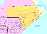
Morgan's Point is a city in Harris County
, Texas, United States located on the shores of the Galveston Bay
at the inlet to the Houston Ship Channel
, near La Porte
and Pasadena
. It earned fame in Texas' early history for being the home of the legendary Emily West (Morgan), known as the Yellow Rose of Texas. It later became an early Houston-area
resort community for the wealthy in the early 20th century. Today, thanks to the construction of the Barbours Cut shipping terminal
, it is at the center of one the area's most important shipping hubs.
to explore and survey the areas between the Brazos
and Lavaca
rivers. He soon sold the property it changed hands to Johnson Calhoun Hunter and then Joseph C. Clopper who used the property to grow orange and lemon
trees. The property was finally sold to James Morgan in 1834 who established the short-lived colony of New Washington. Morgan had helped supply the Texian
army during the Texas Revolution
and was given the rank of colonel. The settlement was destroyed by the Mexican army during the Texas Revolution
. A legend surfaced much later surrounding a mulatto
woman named Emily West. She became an indentured servant (but not a slave) of Morgan and, according to legend, used her beauty to occupy Mexican General Santa Anna
thereby facilitating his capture by the Texan army, thus ending the revolutionary war. Historians differ on the degree of truth of this legend.
The area began to redevelop as the Houston Ship Channel
was dredged near the area in the later 19th century. The community grew around traffic crossing the ship channel to and from Goose Creek (now Baytown
). Ferry service would eventually become established. The Morgan Point Ferry operated until the mid 20th century.
Following the start
of the Texas oil boom
in 1901 Galveston Bay
became an attractive summer destination for the wealthy from Houston and nearby areas. Plots along Bayridge Road were sold for the construction of summer homes including the famed Sterling Mansion, a former governor's residence that is now a landmark (not to be confused with the mansion in Houston). During the 20s and 30s the shoreline between Morgan's Point and Sylvan Beach came to be known as the Texas Gold Coast, a playground for the rich.
As the surrounding communities of La Porte
and Pasadena
grew, interest in the area as a summer haven diminished. Morgan's Point was finally incorporated in 1949 and a small community remained. Some of the original 19th century buildings have remained as well as early 20th century homes.
The area received a major economic boost in 1977 with the opening of the Barbours Cut shipping terminal, operated by the Port of Houston
Authority. However, in building Barbours Cut, the Port of Houston used its power of eminent domain
to evict residents from nearly one third of the community's homes. Still the terminal almost instantly became the Houston area's most important shipping point and became the centerpiece of the economy activity at Morgan's Point.
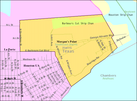 Morgan's Point is located at 29°40′35"N 94°59′58"W (29.676368, -94.999580).
According to the United States Census Bureau
, the city has a total area of 1.8 square miles (4.7 km²), of which, 1.6 square miles (4.1 km²) of it is land and 0.2 square mile (0.517997622 km²) of it (8.47%) is water.
was 208.1 people per square mile (80.6/km²). There were 143 housing units at an average density of 88.6 per square mile (34.3/km²). The racial makeup of the city was 88.69% White, 4.46% African American, 0.89% Native American, 4.46% from other races
, and 1.49% from two or more races. Hispanic or Latino of any race were 12.80% of the population.
There were 111 households out of which 19.8% had children under the age of 18 living with them, 64.9% were married couples living together, 9.0% had a female householder with no husband present, and 23.4% were non-families. 23.4% of all households were made up of individuals and 9.9% had someone living alone who was 65 years of age or older. The average household size was 2.32 and the average family size was 2.64.
In the city the population was spread out with 32.4% under the age of 18, 5.7% from 18 to 24, 19.9% from 25 to 44, 28.0% from 45 to 64, and 14.0% who were 65 years of age or older. The median age was 38 years. For every 100 females there were 114.0 males. For every 100 females age 18 and over, there were 102.7 males.
The median income for a household in the city was $57,917, and the median income for a family was $71,458. Males had a median income of $40,313 versus $30,625 for females. The per capita income
for the city was $32,446. None of the families and 2.2% of the population were living below the poverty line, including no under eighteens and none of those over 64.
and is zoned to La Porte High School.
Harris County, Texas
As of the 2010 Census, the population of the county was 4,092,459, White Americans made up 56.6% of Harris County's population; non-Hispanic whites represented 33.0% of the population. Black Americans made up 18.9% of the population. Native Americans made up 0.7% of Harris County's population...
, Texas, United States located on the shores of the Galveston Bay
Galveston Bay
Galveston Bay is a large estuary located along the upper coast of Texas in the United States. It is connected to the Gulf of Mexico and is surrounded by sub-tropic marshes and prairies on the mainland. The water in the Bay is a complex mixture of sea water and fresh water which supports a wide...
at the inlet to the Houston Ship Channel
Houston Ship Channel
The Houston Ship Channel, located in Houston, Texas, is part of the Port of Houston—one of the United States's busiest seaports. The channel is the conduit for ocean-going vessels between the Houston-area shipyards and the Gulf of Mexico.-Overview:...
, near La Porte
La Porte, Texas
La Porte is a city in Harris County, Texas within the Bay Area of the Houston–Sugar Land–Baytown metropolitan area. As of the 2000 U.S. Census, the city population was 31,880...
and Pasadena
Pasadena, Texas
Pasadena is a city in the U.S. state of Texas within the metropolitan area. It is the second-largest city in Harris County, 17th-largest in Texas, and 162nd largest in the United States. The area was founded in 1893 by John H. Burnett of Galveston....
. It earned fame in Texas' early history for being the home of the legendary Emily West (Morgan), known as the Yellow Rose of Texas. It later became an early Houston-area
Greater Houston
Houston–Sugar Land–Baytown is a 10-county metropolitan area defined by the Office of Management and Budget. It is located along the Gulf Coast region in the U.S. state of Texas...
resort community for the wealthy in the early 20th century. Today, thanks to the construction of the Barbours Cut shipping terminal
Barbours Cut Terminal
The Barbours Cut Container Terminal, or simply the Barbours Cut Terminal, is a major deep water port in the Greater Houston area in the U.S. state of Texas. Part of the larger Port of Houston complex, Barbours Cut is the largest of the terminals and the first port in Texas to handle standardized...
, it is at the center of one the area's most important shipping hubs.
History
The area was first settled in 1822 by Nicholas Rightor, a surveyor commissioned by Stephen F. AustinStephen F. Austin
Stephen Fuller Austin was born in Virginia and raised in southeastern Missouri. He was known as the Father of Texas, led the second, but first legal and ultimately successful colonization of the region by bringing 300 families from the United States. The capital of Texas, Austin in Travis County,...
to explore and survey the areas between the Brazos
Brazos River
The Brazos River, called the Rio de los Brazos de Dios by early Spanish explorers , is the longest river in Texas and the 11th longest river in the United States at from its source at the head of Blackwater Draw, Curry County, New Mexico to its mouth at the Gulf of Mexico with a drainage...
and Lavaca
Lavaca River
The Lavaca River is a river in the U.S. state of Texas. It begins in the northeastern part of Gonzales County, and travels generally southeast for 115 miles until it empties into Lavaca Bay, which is a component of Matagorda Bay.-History:...
rivers. He soon sold the property it changed hands to Johnson Calhoun Hunter and then Joseph C. Clopper who used the property to grow orange and lemon
Lemon
The lemon is both a small evergreen tree native to Asia, and the tree's ellipsoidal yellow fruit. The fruit is used for culinary and non-culinary purposes throughout the world – primarily for its juice, though the pulp and rind are also used, mainly in cooking and baking...
trees. The property was finally sold to James Morgan in 1834 who established the short-lived colony of New Washington. Morgan had helped supply the Texian
Texian
Texian is an archaic, mostly defunct 19th century demonym which defined a settler of current-day Texas, one of the southern states of the United States of America which borders the country of Mexico...
army during the Texas Revolution
Texas Revolution
The Texas Revolution or Texas War of Independence was an armed conflict between Mexico and settlers in the Texas portion of the Mexican state Coahuila y Tejas. The war lasted from October 2, 1835 to April 21, 1836...
and was given the rank of colonel. The settlement was destroyed by the Mexican army during the Texas Revolution
Texas Revolution
The Texas Revolution or Texas War of Independence was an armed conflict between Mexico and settlers in the Texas portion of the Mexican state Coahuila y Tejas. The war lasted from October 2, 1835 to April 21, 1836...
. A legend surfaced much later surrounding a mulatto
Mulatto
Mulatto denotes a person with one white parent and one black parent, or more broadly, a person of mixed black and white ancestry. Contemporary usage of the term varies greatly, and the broader sense of the term makes its application rather subjective, as not all people of mixed white and black...
woman named Emily West. She became an indentured servant (but not a slave) of Morgan and, according to legend, used her beauty to occupy Mexican General Santa Anna
Antonio López de Santa Anna
Antonio de Padua María Severino López de Santa Anna y Pérez de Lebrón , often known as Santa Anna or López de Santa Anna, known as "the Napoleon of the West," was a Mexican political leader, general, and president who greatly influenced early Mexican and Spanish politics and government...
thereby facilitating his capture by the Texan army, thus ending the revolutionary war. Historians differ on the degree of truth of this legend.
The area began to redevelop as the Houston Ship Channel
Houston Ship Channel
The Houston Ship Channel, located in Houston, Texas, is part of the Port of Houston—one of the United States's busiest seaports. The channel is the conduit for ocean-going vessels between the Houston-area shipyards and the Gulf of Mexico.-Overview:...
was dredged near the area in the later 19th century. The community grew around traffic crossing the ship channel to and from Goose Creek (now Baytown
Baytown, Texas
Baytown is a city within Harris County and partially in Chambers County in the Gulf Coast region of the U.S. state of Texas. Located within the Houston–Sugar Land–Baytown metropolitan area, it lies along both State Highway 146 and Interstate 10. As of 2010, Baytown had an population of 71,802...
). Ferry service would eventually become established. The Morgan Point Ferry operated until the mid 20th century.
Following the start
Spindletop
Spindletop is a salt dome oil field located in the southern portion of Beaumont, Texas in the United States. The Spindletop dome was derived from the Louann Salt evaporite layer of the Jurassic geologic period. On January 10, 1901, a well at Spindletop struck oil . The new oil field soon produced...
of the Texas oil boom
Texas Oil Boom
The Texas Oil Boom, sometimes called the Gusher Age, was a period of dramatic change and economic growth in U.S. state of Texas during the early 20th century that began with the discovery of a large petroleum reserve near Beaumont, Texas...
in 1901 Galveston Bay
Galveston Bay
Galveston Bay is a large estuary located along the upper coast of Texas in the United States. It is connected to the Gulf of Mexico and is surrounded by sub-tropic marshes and prairies on the mainland. The water in the Bay is a complex mixture of sea water and fresh water which supports a wide...
became an attractive summer destination for the wealthy from Houston and nearby areas. Plots along Bayridge Road were sold for the construction of summer homes including the famed Sterling Mansion, a former governor's residence that is now a landmark (not to be confused with the mansion in Houston). During the 20s and 30s the shoreline between Morgan's Point and Sylvan Beach came to be known as the Texas Gold Coast, a playground for the rich.
As the surrounding communities of La Porte
La Porte, Texas
La Porte is a city in Harris County, Texas within the Bay Area of the Houston–Sugar Land–Baytown metropolitan area. As of the 2000 U.S. Census, the city population was 31,880...
and Pasadena
Pasadena, Texas
Pasadena is a city in the U.S. state of Texas within the metropolitan area. It is the second-largest city in Harris County, 17th-largest in Texas, and 162nd largest in the United States. The area was founded in 1893 by John H. Burnett of Galveston....
grew, interest in the area as a summer haven diminished. Morgan's Point was finally incorporated in 1949 and a small community remained. Some of the original 19th century buildings have remained as well as early 20th century homes.
The area received a major economic boost in 1977 with the opening of the Barbours Cut shipping terminal, operated by the Port of Houston
Port of Houston
The Port of Houston is a port in Houston—the fourth-largest city in the United States. The Port is a 25-mile-long complex of diversified public and private facilities located a few hours' sailing time from the Gulf of Mexico...
Authority. However, in building Barbours Cut, the Port of Houston used its power of eminent domain
Eminent domain
Eminent domain , compulsory purchase , resumption/compulsory acquisition , or expropriation is an action of the state to seize a citizen's private property, expropriate property, or seize a citizen's rights in property with due monetary compensation, but without the owner's consent...
to evict residents from nearly one third of the community's homes. Still the terminal almost instantly became the Houston area's most important shipping point and became the centerpiece of the economy activity at Morgan's Point.
Geography
According to the United States Census Bureau
United States Census Bureau
The United States Census Bureau is the government agency that is responsible for the United States Census. It also gathers other national demographic and economic data...
, the city has a total area of 1.8 square miles (4.7 km²), of which, 1.6 square miles (4.1 km²) of it is land and 0.2 square mile (0.517997622 km²) of it (8.47%) is water.
Demographics
As of the census of 2000, there were 336 people, 111 households, and 85 families residing in the city. The population densityPopulation density
Population density is a measurement of population per unit area or unit volume. It is frequently applied to living organisms, and particularly to humans...
was 208.1 people per square mile (80.6/km²). There were 143 housing units at an average density of 88.6 per square mile (34.3/km²). The racial makeup of the city was 88.69% White, 4.46% African American, 0.89% Native American, 4.46% from other races
Race (United States Census)
Race and ethnicity in the United States Census, as defined by the Federal Office of Management and Budget and the United States Census Bureau, are self-identification data items in which residents choose the race or races with which they most closely identify, and indicate whether or not they are...
, and 1.49% from two or more races. Hispanic or Latino of any race were 12.80% of the population.
There were 111 households out of which 19.8% had children under the age of 18 living with them, 64.9% were married couples living together, 9.0% had a female householder with no husband present, and 23.4% were non-families. 23.4% of all households were made up of individuals and 9.9% had someone living alone who was 65 years of age or older. The average household size was 2.32 and the average family size was 2.64.
In the city the population was spread out with 32.4% under the age of 18, 5.7% from 18 to 24, 19.9% from 25 to 44, 28.0% from 45 to 64, and 14.0% who were 65 years of age or older. The median age was 38 years. For every 100 females there were 114.0 males. For every 100 females age 18 and over, there were 102.7 males.
The median income for a household in the city was $57,917, and the median income for a family was $71,458. Males had a median income of $40,313 versus $30,625 for females. The per capita income
Per capita income
Per capita income or income per person is a measure of mean income within an economic aggregate, such as a country or city. It is calculated by taking a measure of all sources of income in the aggregate and dividing it by the total population...
for the city was $32,446. None of the families and 2.2% of the population were living below the poverty line, including no under eighteens and none of those over 64.
Education
Morgan's Point is within the La Porte Independent School DistrictLa Porte Independent School District
La Porte Independent School District is a school district based in La Porte, Texas, United States.The district serves the cities of La Porte, Morgan's Point, and Shoreacres, a small portion of Pasadena, a small portion of Deer Park...
and is zoned to La Porte High School.
See also
- Emily West Morgan
- The Yellow Rose of TexasThe Yellow Rose of Texas"The Yellow Rose of Texas" is a traditional folk song. The original love song has become associated with the legend of how an indentured servant named Emily Morgan "helped win the battle of San Jacinto, the decisive battle in the Texas Revolution."...
- Galveston Bay AreaGalveston Bay AreaThe Galveston Bay Area is a region that surrounds the Galveston Bay estuary of Southeast Texas in the United States within the metropolitan area. Residents of Houston and surrounding areas typically call it simply the "Bay Area"...
- Greater HoustonGreater HoustonHouston–Sugar Land–Baytown is a 10-county metropolitan area defined by the Office of Management and Budget. It is located along the Gulf Coast region in the U.S. state of Texas...
External links
- City of Morgan's Point website
- The University of Houston Digital Library has a collection of historical photographs about Houston, nearby communities, and more. View these collections at the University of Houston Digital Libraries