Moorabool Shire
Encyclopedia
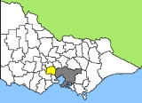
The Shire of Moorabool is a Local Government Area in Victoria, Australia. It is located in the southwestern part of the state. It has an area of 2,110 square kilometres. In 2006 it had a population of 25,474.
The administrative centre is at Ballan
, while the largest urban centre is Bacchus Marsh
. Other small population areas in the east are Balliang, Mount Wallace and Myrniong
, in the centre Blackwood
, Greendale
, Gordon
, Koorweinguboora and Mount Egerton
and to the west Bungaree
, Elaine
and Wallace
.
The shire was formed in 1994 by the amalgamation of the Shire of Bacchus Marsh
, Shire of Ballan
and parts of Shire of Bungaree
and the City of Werribee.
East Moorabool ward is represented by four elected Councillors, the other wards by one elected Councillor.
The administrative centre is at Ballan
Ballan, Victoria
Ballan is a small town in the state of Victoria, Australia located on the Werribee River north west of Melbourne. At the 2006 census, Ballan had a population of 1,807.It is the main administrative centre for the Shire of Moorabool Local Government Area....
, while the largest urban centre is Bacchus Marsh
Bacchus Marsh, Victoria
Bacchus Marsh is an urban centre and suburban locality in Victoria, Australia located approximately west of Melbourne and west of Melton. The population of the urban area is estimated at over 17,000 people, while the central locality is home to 5,566 people...
. Other small population areas in the east are Balliang, Mount Wallace and Myrniong
Myrniong, Victoria
Myrniong is a town in Victoria, Australia. The town is located near the Western Freeway, north west of the state capital, Melbourne and west of Bacchus Marsh. Situated close by the Lerderderg River, at the 2006 census, Myrniong had a population of 210...
, in the centre Blackwood
Blackwood, Victoria
Blackwood is a town in Victoria, Australia. The town is located on the Lerderderg River, 89 kilometres north west of the state capital, Melbourne. Blackwood is in the Shire of Moorabool Local Government Area and had a population of 235 at the 2006 census....
, Greendale
Greendale, Victoria
Greendale is a town in central Victoria, Australia. The town is located in the Shire of Moorabool Local Government Area, west north west of the state capital, Melbourne...
, Gordon
Gordon, Victoria
Gordon is a town in Victoria, Australia. The town is located in the Shire of Moorabool Local Government Area, west of the state capital, Melbourne. At the 2006 census, Gordon had a population of 453....
, Koorweinguboora and Mount Egerton
Mount Egerton, Victoria
Mount Egerton is a town in Victoria, Australia. The town is located in the Shire of Moorabool Local Government Area, north west of the state capital, Melbourne. At the 2006 census, Mount Egerton had a population of 215....
and to the west Bungaree
Bungaree, Victoria
Bungaree is a town in Victoria, Australia. The town is located west of the state capital, Melbourne and east of the regional centre of Ballarat, on the Western Freeway and in the Shire of Moorabool local government area. At the 2006 census, Bungaree and the surrounding area had a population of...
, Elaine
Elaine, Victoria
Elaine is a town in Victoria, Australia, located on the Midland Highway between Ballarat and Geelong. At the 2006 census, Elaine and the surrounding area had a population of 677....
and Wallace
Wallace, Victoria
Wallace is a town in Victoria, Australia. The town is located in the Shire of Moorabool Local Government Area, north west of the state capital, Melbourne.The township was established in the 1880s, the Post Office opening on 22 February 1885....
.
The shire was formed in 1994 by the amalgamation of the Shire of Bacchus Marsh
Shire of Bacchus Marsh
The Shire of Bacchus Marsh was a Local Government Area located about west of Melbourne, the state capital of Victoria, Australia. The shire covered an area of , and existed from 1862 until 1994.-History:...
, Shire of Ballan
Shire of Ballan
The Shire of Ballan was a Local Government Area located about west of Melbourne, the state capital of Victoria, Australia. The shire covered an area of , and existed from 1862 until 1994.-History:...
and parts of Shire of Bungaree
Shire of Bungaree
The Shire of Bungaree was a Local Government Area located northeast of the regional city of Ballarat, Victoria, Australia. The shire covered an area of , and existed from 1863 until 1994.-History:...
and the City of Werribee.
Wards
- Bungal
- East Moorabool
- West Moorabool
- Woodlands
East Moorabool ward is represented by four elected Councillors, the other wards by one elected Councillor.

