
Mont Clare Bridge
Encyclopedia
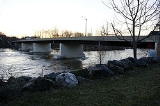
The Mont Clare Bridge is a crossing of the Schuylkill River
between Mont Clare
and Phoenixville
in Pennsylvania
, USA. The bridge was also referred to as the Intercounty Bridge, as it connects Montgomery
and Chester
counties. The bridge abuts a shorter county bridge across the Schuylkill Canal
and towpath
on the Mont Clare side to complete the crossing. The bridges carry Bridge Street (PA29), a bike lane and a sidewalk. The bridge will also become part of the Schuylkill River Trail
routing.
known originally as Indian or Indiantown Ford. Then successively as Gordon's, Starr's and Jacobs' Ford. The crossing gained some notoriety as Gordon's Ford when it was used by American and British troops during the American Revolutionary War
. In the fall of 1777, British troops under Lord Cornwallis
forced a passage at Gordon's Ford and at Fatland Ford, further downstream. In response, Washington
maneuvered the Continental Army further west to protect his supply line and Congress in York
, leaving Philadelphia lightly defended. This led to the fall of Philadelphia. Gordon's Ford is mentioned in the writings of both Washington and Cornwallis.
was constructed, it was one of the longest in regional history. In early 1915, state highway engineers formally recommended to the County Commissioners that the bridge be replaced. Then fate took a hand and the covered bridge burned down on 9 May 1915. A temporary wooden replacement bridge was built on piles, just down stream from the previous, until the permanent replacement could be built.
's Pittsburgh office and Czop/Specter,Inc. of Worcester, Montgomery County, PA office. Construction was done by Allan A. Myers Inc. of Worcester, Pennsylvania. Many design decisions were based on the requirement to keep the closure of State Route 29 to a minimum. The project was kept to a short time line by reusing the existing bridge foundations, using steel girders, and an incentive clause in the contract. The new bridge opened in 1997. The new bridge was the first in Pennsylvania to include "shock transmission units", an earthquake
damage mitigation technology.
As Chester County constructs a new section of the Schuylkill River Trail
north of Phoenixville, the Mont Clare Bridge will be used to connect it to the existing portion of trail that runs from Mont Clare to Philadelphia.
Schuylkill River
The Schuylkill River is a river in Pennsylvania. It is a designated Pennsylvania Scenic River.The river is about long. Its watershed of about lies entirely within the state of Pennsylvania. The source of its eastern branch is in the Appalachian Mountains at Tuscarora Springs, near Tamaqua in...
between Mont Clare
Mont Clare, Pennsylvania
Mont Clare is a village in Upper Providence Township, Montgomery County, Pennsylvania, USA. The village is located on the left bank of the Schuylkill River, opposite Phoenixville, at the site of the former Jacobs' ford. Mont Clare hosts the only functional lock and one of only two remaining...
and Phoenixville
Phoenixville, Pennsylvania
Phoenixville is a borough in Chester County, Pennsylvania, United States, northwest of Philadelphia, at the junction of French Creek with the Schuylkill River. The population is 16,440 as of the 2010 Census.- History :...
in Pennsylvania
Pennsylvania
The Commonwealth of Pennsylvania is a U.S. state that is located in the Northeastern and Mid-Atlantic regions of the United States. The state borders Delaware and Maryland to the south, West Virginia to the southwest, Ohio to the west, New York and Ontario, Canada, to the north, and New Jersey to...
, USA. The bridge was also referred to as the Intercounty Bridge, as it connects Montgomery
Montgomery County, Pennsylvania
Montgomery County is a county located in the U.S. state of Pennsylvania, in the United States. As of 2010, the population was 799,874, making it the third most populous county in Pennsylvania . The county seat is Norristown.The county was created on September 10, 1784, out of land originally part...
and Chester
Chester County, Pennsylvania
-State parks:*French Creek State Park*Marsh Creek State Park*White Clay Creek Preserve-Demographics:As of the 2010 census, the county was 85.5% White, 6.1% Black or African American, 0.2% Native American or Alaskan Native, 3.9% Asian, 0.0% Native Hawaiian, 1.8% were two or more races, and 2.4% were...
counties. The bridge abuts a shorter county bridge across the Schuylkill Canal
Schuylkill Canal
Schuylkill Canal is the common, but technically inaccurate, name for the Schuylkill Navigation, a 19th-century commercial waterway in and along the Schuylkill River in the U.S. state of Pennsylvania. The "canal" was actually a system of interconnected man-made canals and slack-water pools in the...
and towpath
Towpath
A towpath is a road or trail on the bank of a river, canal, or other inland waterway. The purpose of a towpath is to allow a land vehicle, beasts of burden, or a team of human pullers to tow a boat, often a barge...
on the Mont Clare side to complete the crossing. The bridges carry Bridge Street (PA29), a bike lane and a sidewalk. The bridge will also become part of the Schuylkill River Trail
Schuylkill River Trail
The Schuylkill River Trail is a multi-use trail under construction for expansion along the banks of the Schuylkill River in southeastern Pennsylvania...
routing.
History
In early America, the crossing was a fordFord (crossing)
A ford is a shallow place with good footing where a river or stream may be crossed by wading or in a vehicle. A ford is mostly a natural phenomenon, in contrast to a low water crossing, which is an artificial bridge that allows crossing a river or stream when water is low.The names of many towns...
known originally as Indian or Indiantown Ford. Then successively as Gordon's, Starr's and Jacobs' Ford. The crossing gained some notoriety as Gordon's Ford when it was used by American and British troops during the American Revolutionary War
American Revolutionary War
The American Revolutionary War , the American War of Independence, or simply the Revolutionary War, began as a war between the Kingdom of Great Britain and thirteen British colonies in North America, and ended in a global war between several European great powers.The war was the result of the...
. In the fall of 1777, British troops under Lord Cornwallis
Charles Cornwallis, 1st Marquess Cornwallis
Charles Cornwallis, 1st Marquess Cornwallis KG , styled Viscount Brome between 1753 and 1762 and known as The Earl Cornwallis between 1762 and 1792, was a British Army officer and colonial administrator...
forced a passage at Gordon's Ford and at Fatland Ford, further downstream. In response, Washington
George Washington
George Washington was the dominant military and political leader of the new United States of America from 1775 to 1799. He led the American victory over Great Britain in the American Revolutionary War as commander-in-chief of the Continental Army from 1775 to 1783, and presided over the writing of...
maneuvered the Continental Army further west to protect his supply line and Congress in York
York, Pennsylvania
York, known as the White Rose City , is a city located in York County, Pennsylvania, United States which is in the South Central region of the state. The population within the city limits was 43,718 at the 2010 census, which was a 7.0% increase from the 2000 count of 40,862...
, leaving Philadelphia lightly defended. This led to the fall of Philadelphia. Gordon's Ford is mentioned in the writings of both Washington and Cornwallis.
1844 bridge
In the winter of 1843-1844, local businessman Joseph Whitaker, while in the legislature, "obtained a charter for the incorporation of a company to erect a bridge over the Schuylkill at the site of th[e] ford". That summer, a wooden covered bridgeCovered bridge
A covered bridge is a bridge with enclosed sides and a roof, often accommodating only a single lane of traffic. Most covered bridges are wooden; some newer ones are concrete or metal with glass sides...
was constructed, it was one of the longest in regional history. In early 1915, state highway engineers formally recommended to the County Commissioners that the bridge be replaced. Then fate took a hand and the covered bridge burned down on 9 May 1915. A temporary wooden replacement bridge was built on piles, just down stream from the previous, until the permanent replacement could be built.
1916 bridge
In December 1915, the County Commissioners of Montgomery and Chester Counties requested sealed bids for a five span, concrete arch bridge. In 1916 construction started on the new bridge, which was completed in April 1917. The 1916 bridge was designed by B. H. Davis and constructed by Ambler-Davis Co. Each of the five concrete arches spanned 103 feet (31.4 m), and the cost was US$103,250.1997 bridge
In 1996 a contract was let to replace the 1916 bridge. The new bridge was designed by HDR, Inc.HDR, Inc.
HDR Inc. is an employee-owned architectural, engineering and consulting firm based in Omaha, Nebraska, USA. HDR has worked on projects in all 50 U.S. states and in 60 countries, including notable projects such as the Hoover Dam Bypass, TD Ameritrade Park Omaha, and the The Roslin Institute building...
's Pittsburgh office and Czop/Specter,Inc. of Worcester, Montgomery County, PA office. Construction was done by Allan A. Myers Inc. of Worcester, Pennsylvania. Many design decisions were based on the requirement to keep the closure of State Route 29 to a minimum. The project was kept to a short time line by reusing the existing bridge foundations, using steel girders, and an incentive clause in the contract. The new bridge opened in 1997. The new bridge was the first in Pennsylvania to include "shock transmission units", an earthquake
Earthquake
An earthquake is the result of a sudden release of energy in the Earth's crust that creates seismic waves. The seismicity, seismism or seismic activity of an area refers to the frequency, type and size of earthquakes experienced over a period of time...
damage mitigation technology.
As Chester County constructs a new section of the Schuylkill River Trail
Schuylkill River Trail
The Schuylkill River Trail is a multi-use trail under construction for expansion along the banks of the Schuylkill River in southeastern Pennsylvania...
north of Phoenixville, the Mont Clare Bridge will be used to connect it to the existing portion of trail that runs from Mont Clare to Philadelphia.