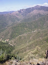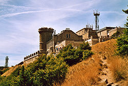
Mont Aigoual
Encyclopedia

Gard
Gard is a département located in southern France in the Languedoc-Roussillon region.The department is named after the River Gard, although the formerly Occitan name of the River Gard, Gardon, has been replacing the traditional French name in recent decades, even among French speakers.- History...
département, France
France
The French Republic , The French Republic , The French Republic , (commonly known as France , is a unitary semi-presidential republic in Western Europe with several overseas territories and islands located on other continents and in the Indian, Pacific, and Atlantic oceans. Metropolitan France...
. It is part of the Massif Central
Massif Central
The Massif Central is an elevated region in south-central France, consisting of mountains and plateaux....
, and it is located within the Cévennes National Park
Cévennes National Park
The Cévennes National Park is a national park located in southern France, in the mountainous area of Cévennes.Created in 1970, the park has its administrative seat in Florac at Florac Castle. It is located mainly in the départements of Lozère and Gard, and covers some parts of Ardèche and Aveyron...
.
This granite and schist outcrop is a major water catchment area in the Massif Central, being located where clouds from the cold Atlantic converge with warm Mediterranean air currents. The heavy rainfall has given the mountain its name: originally "Aiqualis" ('the watery one'). In an average year rainfall can measure up to 2250 mm (over 7 ft), making it the wettest place in France. Mont Aigoual forms part of the watershed
Water divide
A drainage divide, water divide, divide or watershed is the line separating neighbouring drainage basins...
between the Mediterranean and Atlantic.
The meteorological observatory, built in 1887 by the French Rivers Authority and Forestry Commission under the direction of Georges Fabre
Georges Fabre
Georges Fabre was a French forestry engineer, now best known for his role in creation of the Forêt Domaniale de l'Aigoual and the weather observatory atop Mont Aigoual....
, is currently occupied by the French meteorological service (Météo France). It is the last remaining weather station
Weather station
A weather station is a facility, either on land or sea, with instruments and equipment for observing atmospheric conditions to provide information for weather forecasts and to study the weather and climate. The measurements taken include temperature, barometric pressure, humidity, wind speed, wind...
in France
France
The French Republic , The French Republic , The French Republic , (commonly known as France , is a unitary semi-presidential republic in Western Europe with several overseas territories and islands located on other continents and in the Indian, Pacific, and Atlantic oceans. Metropolitan France...
which is still inhabited by meteorologists. An exhibition on weather forecasting is open to visitors in the summer months.
Severe weather conditions are sometimes recorded:
- Maximum Temperature : 28.2 °C in 1947;
- Minimum Temperature : -28 °C in 1956;
- Maximum wind speed : 360 km/h on November 6, 1966;
- Maximum rain in 24 hours: 607 mm from 6 p.m. on 30th to 6 p.m. on October 31, 1963;
- Maximum snow during one year : 10.24 metres;
- Frozen days: 144;
- High temperature days (> 25 °C) : 0;
- Rain days: 170;
- High wind days (> 16 m/s) : 265;
- Fog days: 241;
- Days with snow: 116.
When the sky is clear, it is possible to see the Mediterranean Sea
Mediterranean Sea
The Mediterranean Sea is a sea connected to the Atlantic Ocean surrounded by the Mediterranean region and almost completely enclosed by land: on the north by Anatolia and Europe, on the south by North Africa, and on the east by the Levant...
, the Pyrenees
Pyrenees
The Pyrenees is a range of mountains in southwest Europe that forms a natural border between France and Spain...
, and also the Alps
Alps
The Alps is one of the great mountain range systems of Europe, stretching from Austria and Slovenia in the east through Italy, Switzerland, Liechtenstein and Germany to France in the west....
and Mont Blanc
Mont Blanc
Mont Blanc or Monte Bianco , meaning "White Mountain", is the highest mountain in the Alps, Western Europe and the European Union. It rises above sea level and is ranked 11th in the world in topographic prominence...
in particular. The summit is accessible by car from a variety of converging surfaced approaches.

