
Monroe, Ohio
Encyclopedia
Monroe is a city located in east central Butler
and west central Warren
counties in the southwestern part of the U.S. state
of Ohio
. As of 2007, the city population was 7,655, up from 4,008 in 1990.
Monroe is named for President James Monroe
, who was elected U.S. President the year it was founded.
According to the United States Census Bureau
, the city has a total area of 15.5 square miles (40.2 km²), of which, 15.5 square miles (40.2 km²) of it is land and 0.04 square miles (0.1 km²) of it (0.13%) is water.
of 2000, there were 7,133 people, 2,685 households, and 2,040 families residing in the city. The population density
was 459.9 people per square mile (177.6/km²). There were 2,822 housing units at an average density of 182.0 per square mile (70.3/km²). The racial makeup of the city was 97.15% White, 1.42% African American, 0.10% Native American, 0.34% Asian, 0.22% from other races
, and 0.77% from two or more races. Hispanic or Latino of any race were 0.64% of the population.
There were 2,685 households out of which 32.4% had children under the age of 18 living with them, 65.1% were married couples
living together, 6.9% had a female householder with no husband present, and 24.0% were non-families. 20.3% of all households were made up of individuals and 9.3% had someone living alone who was 65 years of age or older. The average household size was 2.52 and the average family size was 2.91.
In the city the population was spread out with 22.8% under the age of 18, 6.5% from 18 to 24, 29.1% from 25 to 44, 22.6% from 45 to 64, and 19.0% who were 65 years of age or older. The median age was 40 years. For every 100 females there were 91.7 males. For every 100 females age 18 and over, there were 88.3 males.
The median income for a household in the city was $56,012, and the median income for a family was $62,528. Males had a median income of $44,864 versus $27,385 for females. The per capita income
for the city was $24,735. About 1.0% of families and 1.9% of the population were below the poverty line, including 0.4% of those under age 18 and 2.1% of those age 65 or over.
with some falling in the Lakota School District. Telephone service is provided through the Monroe, Middletown
, and Mason
telephone exchanges. Mail is delivered through the Monroe, Middletown, and Lebanon
post offices.
Butler County, Ohio
Butler County is a county located in the state of Ohio, United States. As of 2010, the population was 368,130. Its county seat is Hamilton. It is named for General Richard Butler, who died in 1791 fighting Indians in northern Ohio. Butler's army marched out of Fort Hamilton, where the city of...
and west central Warren
Warren County, Ohio
Warren County is a county located in the state of Ohio, United States. The population was 212,693 at the 2010 census. Its county seat is Lebanon. Warren County was erected May 1, 1803, from Hamilton County, and named for Dr...
counties in the southwestern part of the U.S. state
U.S. state
A U.S. state is any one of the 50 federated states of the United States of America that share sovereignty with the federal government. Because of this shared sovereignty, an American is a citizen both of the federal entity and of his or her state of domicile. Four states use the official title of...
of Ohio
Ohio
Ohio is a Midwestern state in the United States. The 34th largest state by area in the U.S.,it is the 7th‑most populous with over 11.5 million residents, containing several major American cities and seven metropolitan areas with populations of 500,000 or more.The state's capital is Columbus...
. As of 2007, the city population was 7,655, up from 4,008 in 1990.
Monroe is named for President James Monroe
James Monroe
James Monroe was the fifth President of the United States . Monroe was the last president who was a Founding Father of the United States, and the last president from the Virginia dynasty and the Republican Generation...
, who was elected U.S. President the year it was founded.
Geography
Monroe is located at 39°26′41"N 84°21′51"W (39.444658, −84.364044).According to the United States Census Bureau
United States Census Bureau
The United States Census Bureau is the government agency that is responsible for the United States Census. It also gathers other national demographic and economic data...
, the city has a total area of 15.5 square miles (40.2 km²), of which, 15.5 square miles (40.2 km²) of it is land and 0.04 square miles (0.1 km²) of it (0.13%) is water.
Demographics
As of the censusCensus
A census is the procedure of systematically acquiring and recording information about the members of a given population. It is a regularly occurring and official count of a particular population. The term is used mostly in connection with national population and housing censuses; other common...
of 2000, there were 7,133 people, 2,685 households, and 2,040 families residing in the city. The population density
Population density
Population density is a measurement of population per unit area or unit volume. It is frequently applied to living organisms, and particularly to humans...
was 459.9 people per square mile (177.6/km²). There were 2,822 housing units at an average density of 182.0 per square mile (70.3/km²). The racial makeup of the city was 97.15% White, 1.42% African American, 0.10% Native American, 0.34% Asian, 0.22% from other races
Race (United States Census)
Race and ethnicity in the United States Census, as defined by the Federal Office of Management and Budget and the United States Census Bureau, are self-identification data items in which residents choose the race or races with which they most closely identify, and indicate whether or not they are...
, and 0.77% from two or more races. Hispanic or Latino of any race were 0.64% of the population.
There were 2,685 households out of which 32.4% had children under the age of 18 living with them, 65.1% were married couples
Marriage
Marriage is a social union or legal contract between people that creates kinship. It is an institution in which interpersonal relationships, usually intimate and sexual, are acknowledged in a variety of ways, depending on the culture or subculture in which it is found...
living together, 6.9% had a female householder with no husband present, and 24.0% were non-families. 20.3% of all households were made up of individuals and 9.3% had someone living alone who was 65 years of age or older. The average household size was 2.52 and the average family size was 2.91.
In the city the population was spread out with 22.8% under the age of 18, 6.5% from 18 to 24, 29.1% from 25 to 44, 22.6% from 45 to 64, and 19.0% who were 65 years of age or older. The median age was 40 years. For every 100 females there were 91.7 males. For every 100 females age 18 and over, there were 88.3 males.
The median income for a household in the city was $56,012, and the median income for a family was $62,528. Males had a median income of $44,864 versus $27,385 for females. The per capita income
Per capita income
Per capita income or income per person is a measure of mean income within an economic aggregate, such as a country or city. It is calculated by taking a measure of all sources of income in the aggregate and dividing it by the total population...
for the city was $24,735. About 1.0% of families and 1.9% of the population were below the poverty line, including 0.4% of those under age 18 and 2.1% of those age 65 or over.
Historic population figures
- 1910—255
- 1920—266
- 1930—285
- 1940—307
- 1950—360
- 1960—2,193
- 1970—3,492
- 1980—4,256
- 1990—4,490
- 2000—7,133
Schools and utilities
Most of the city is in the Monroe Local School DistrictLemon-Monroe High School
Monroe Senior High School is a high school in Monroe, Ohio. It is the only high school in the Monroe Local Schools district.-History:The Monroe Local Schools was originally a joint district between the village of Monroe and Lemon Township. In the 1950s the district joined the Middletown Local...
with some falling in the Lakota School District. Telephone service is provided through the Monroe, Middletown
Middletown, Ohio
Middletown is an All-America City located in Butler and Warren counties in the southwestern part of the U.S. state of Ohio. Formerly in Lemon, Turtlecreek, and Franklin townships, Middletown was incorporated by the Ohio General Assembly on February 11, 1833, and became a city in 1886...
, and Mason
Mason, Ohio
Mason is an affluent city in southwestern Warren County, Ohio, United States, 22 miles away from Cincinnati . As of the 2010 census, Mason's population was 30,712. Mason has experienced fast growth, with its historic Main Street remaining at the center of the community...
telephone exchanges. Mail is delivered through the Monroe, Middletown, and Lebanon
Lebanon, Ohio
The population at the 2010 census was 20,033. As of the census of 2000, there were 16,962 people residing in the city. The population density was 1,440.6 people per square mile . There were 6,218 housing units at an average density of 528.1 per square mile...
post offices.
Tourism
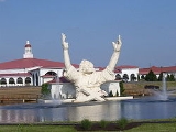
- King of Kings (also known as "Touchdown Jesus" or "Big Butter Jesus" or the new name "Terminator Jesus"), a 62-foot-tall sculpture of JesusJesusJesus of Nazareth , commonly referred to as Jesus Christ or simply as Jesus or Christ, is the central figure of Christianity...
, appears to be rising from the waters behind the amphitheater at Monroe's Solid Rock Church. The massive statue was struck by lightning on June 14, 2010, and burnt to the ground. - Traders World Flea Market
- Treasure Aisles (formerly Turtlecreek Flea Market)
- Cincinnati Premium Outlets, one of the biggest outlet malls in the country.