

Mongolian manuscript maps
Encyclopedia
Aimag
Aimag is a Mongolian and Turkic word for a tribe.It is also used as a term for country subdivisions in Mongolia and China, see aimag .The name of the Aimak people in central Afghanistan derives from the same root....
s) in Greater Mongolia
Greater Mongolia
Greater Mongolia as a region, is the contiguous territories primarily inhabited by ethnic Mongols. It approximately includes the modern state of Mongolia, the Inner Mongolia Autonomous Region in the People's Republic of China , and the Buryat Republic as well as a few smaller territories in...
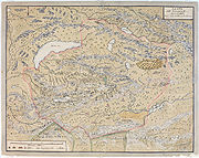
. They gave a bird's eye view
Bird's Eye View
"Bird's Eye View" is a single by Oakland Hip Hop group Zion I, released in 2005 on Live Up Records. The single was the first released from their third album True & Livin. The song, like Common's classic "I Used to Love H.E.R.", addresses the state of Hip Hop by comparing the culture to a woman. The...
of the area depicted, making them somewhat similar to Pictorial maps
Pictorial maps
Pictorial maps are a category of maps that are also loosely called illustrated maps, panoramic maps, perspective maps, bird’s-eye view maps and Geopictorial maps amongst others. In contrast to the regular road map, Atlas or topographic cartography, pictorial maps depict a given territory with a...
. Such manuscript maps have been used for official purposes by the Qing
Qing Dynasty
The Qing Dynasty was the last dynasty of China, ruling from 1644 to 1912 with a brief, abortive restoration in 1917. It was preceded by the Ming Dynasty and followed by the Republic of China....
since the 17th century, and new maps continued to be drawn until at least the 1930s.
Although the roots of Mongolian cartography are probably older, the manuscript maps known today were all produced after 1690, when the Lifanyuan in Beijing
Beijing
Beijing , also known as Peking , is the capital of the People's Republic of China and one of the most populous cities in the world, with a population of 19,612,368 as of 2010. The city is the country's political, cultural, and educational center, and home to the headquarters for most of China's...
ordered all Mongolian nobles to produce maps of their territory. Updated maps were to be made every ten years and sent to the Lifanyuan. The maps show major geographic features, and give the positions of those (usually 24 or 48) ovoo
Ovoo
An ovoo is a type of shamanistic cairn found in Mongolia, usually made from rocks or from wood. Ovoos are often found at the top of mountains and in high places, like mountain passes...
s that marked the border. The maps normally had Mongolian
Mongolian language
The Mongolian language is the official language of Mongolia and the best-known member of the Mongolic language family. The number of speakers across all its dialects may be 5.2 million, including the vast majority of the residents of Mongolia and many of the Mongolian residents of the Inner...
captions, some were bilingual, others bear small slips of paper with the Chinese
Chinese language
The Chinese language is a language or language family consisting of varieties which are mutually intelligible to varying degrees. Originally the indigenous languages spoken by the Han Chinese in China, it forms one of the branches of Sino-Tibetan family of languages...
translation of the Mongolian names.
Mongolian manuscript maps were first brought to the attention of European scientists by August Strindberg
August Strindberg
Johan August Strindberg was a Swedish playwright, novelist, poet, essayist and painter. A prolific writer who often drew directly on his personal experience, Strindberg's career spanned four decades, during which time he wrote over 60 plays and more than 30 works of fiction, autobiography,...
, who in 1878 wrote an article about Dzungarian maps brought to Sweden
Sweden
Sweden , officially the Kingdom of Sweden , is a Nordic country on the Scandinavian Peninsula in Northern Europe. Sweden borders with Norway and Finland and is connected to Denmark by a bridge-tunnel across the Öresund....
by Johan Gustaf Renat
Johan Gustaf Renat
Johan Gustaf Renat was a Swedish military and cartographer. He is mainly known for his role in bringing detailed maps of Central Asia to Europe after several years in captivity.-Early career and Russian Captivity:...
.
Old Mongolian maps also played a role in the Japanese claims about the western border of Manchuguo in the run-up to the Battle of Khalkhin Gol
Battle of Khalkhin Gol
The Battles of Khalkhyn Gol was the decisive engagement of the undeclared Soviet–Japanese Border Wars fought among the Soviet Union, Mongolia and the Empire of Japan in 1939. The conflict was named after the river Khalkhyn Gol, which passes through the battlefield...
.
Further reading
- Magadbürin Haltod (author)/Walther Heissig (editor), Mongolische Ortsnamen I, Stuttgart 1966
- Walther Heissig (editor), Mongolische Ortsnamen II. Mongolische Manuskriptkarten in Faksimilia, Stuttgart 1978