
Mole Valley
Encyclopedia
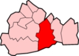
Mole Valley is a local government district
in Surrey
, England
. Its council is based in Dorking
.
The district, named after the River Mole
, was formed on 1 April 1974, under the Local Government Act 1972
, by a merger of the urban districts of Dorking and Leatherhead and most of the Dorking and Horley Rural District. The two towns in the district are Dorking
and Leatherhead
. The largest villages are Ashtead
, Fetcham
and Great Bookham
, all of which are in the northern third of the district.
The Council was, however, re-elected whole in 2000
after wholesale boundary changes to the Wards.
Traditionally, despite Mole Valley Constituency's strongly Conservative leaning, Mole Valley District Council is usually in no overall control. There have been two exceptions to this: 1980-82 - Independent control and 2006-10 - Conservative control. Mole Valley currently has a Conservative-Independent Coalition, while the Liberal Democrats are the largest single party and official opposition.
http://www.britishgasnews.co.uk/managed_content/files/pdf/greenCity.pdf showed that housing in Mole Valley produced the twentieth highest average carbon emissions in the country at 6,928 kg of carbon dioxide
per dwelling.
In 2008 a group of residents got together and formed The Green Mole Forum http://www.greenmoleforum.org/ with the aim of promoting sustainable development in Mole Valley both by providing a hub to help residents, and to lobby the council to undertake more sustainable policies.
Non-metropolitan district
Non-metropolitan districts, or colloquially shire districts, are a type of local government district in England. As created, they are sub-divisions of non-metropolitan counties in a so-called "two-tier" arrangement...
in Surrey
Surrey
Surrey is a county in the South East of England and is one of the Home Counties. The county borders Greater London, Kent, East Sussex, West Sussex, Hampshire and Berkshire. The historic county town is Guildford. Surrey County Council sits at Kingston upon Thames, although this has been part of...
, England
England
England is a country that is part of the United Kingdom. It shares land borders with Scotland to the north and Wales to the west; the Irish Sea is to the north west, the Celtic Sea to the south west, with the North Sea to the east and the English Channel to the south separating it from continental...
. Its council is based in Dorking
Dorking
Dorking is a historic market town at the foot of the North Downs approximately south of London, in Surrey, England.- History and development :...
.
The district, named after the River Mole
River Mole, Surrey
The River Mole is a tributary of the River Thames in southern England. It rises in West Sussex near Gatwick Airport and flows north west through Surrey for to the Thames near Hampton Court Palace. The river gives its name to the Surrey district of Mole Valley...
, was formed on 1 April 1974, under the Local Government Act 1972
Local Government Act 1972
The Local Government Act 1972 is an Act of Parliament in the United Kingdom that reformed local government in England and Wales on 1 April 1974....
, by a merger of the urban districts of Dorking and Leatherhead and most of the Dorking and Horley Rural District. The two towns in the district are Dorking
Dorking
Dorking is a historic market town at the foot of the North Downs approximately south of London, in Surrey, England.- History and development :...
and Leatherhead
Leatherhead
Leatherhead is a town in the County of Surrey, England, on the River Mole, part of Mole Valley district. It is thought to be of Saxon origin...
. The largest villages are Ashtead
Ashtead
Ashtead is a village situated within the Metropolitan Green Belt of Surrey, England, and is just outside of the suburbia of London. It is separated from Leatherhead by the M25, and from Epsom by Ashtead Common.- History :...
, Fetcham
Fetcham
Fetcham is a village in Surrey, England. It is west of Leatherhead, on the other side of the River Mole and Mill Pond springs and the associated nature reserve....
and Great Bookham
Great Bookham
-Today:The village has a high street, located in Great Bookham, which is, as its name suggests, the larger of the two villages. It has two butchers, a family run fishmongers and two traditional greengrocers...
, all of which are in the northern third of the district.
Civil parishes
These are- AbingerAbingerAbinger is a civil parish in the Mole Valley district of Surrey, England. It includes the villages of Abinger Hammer, Sutton Abinger, Abinger Common and part of Holmbury St Mary ....
- BetchworthBetchworthBetchworth is a village and civil parish in the Mole Valley district of Surrey, England. The village lies on the north bank of the River Mole, off the A25 road, about three miles east of Dorking and three miles west of Reigate. The village lay within the Reigate hundred.It was home to the now...
- BrockhamBrockhamBrockham is a village in the Mole Valley district of Surrey, England. 'Broc-ham' is so called from the Anglo Saxon meaning 'river meadow by the brook' and is first recorded in 1241. It is often mistakenly believed that there is an association with badgers but this is a modern affectation from the...
- BucklandBuckland, SurreyBuckland is a village and civil parish in the Mole Valley district of Surrey, England. The village is situated between Dorking and Reigate. The civil parish of Buckland covers 515 hectares and is bordered by the North Downs escarpment in the north. The area contains a number of clay pits.Buckland...
- Capel
- CharlwoodCharlwoodCharlwood is a village and civil parish in the Mole Valley district of Surrey, England. It is immediately northwest of London Gatwick Airport in West Sussex, close west of Horley and north of Crawley. The historic county boundary between Surrey and Sussex ran to the south of Gatwick Airport...
- HeadleyHeadley, SurreyHeadley is a small village and civil parish in Surrey, England covering 675 hectares.The village is bordered to its west by Leatherhead, to the north by Ashtead and Langley Vale, Walton-on-the-Hill to the east and to its south by Box Hill. It is just outside the M25 motorway encircling...
- HolmwoodHolmwoodHolmwood is a civil parish in Surrey, England. The parish has a population of 850.Holmwood forms part of Mole Valley Borough Council's area; the main settlements are North Holmwood and South Holmwood both of which are bypassed by the A24 road. The smaller settlement of Mid Holmwood is alongside the...
- LeighLeigh, SurreyLeigh is a village and civil parish in Surrey, between Reigate and Dorking.It is located in the Mole Valley district. The civil parish has a population of 856 and covers 1,382 hectares....
- MicklehamMickleham, SurreyMickleham is a village and civil parish between the towns of Dorking and Leatherhead in Surrey, England covering . The parish includes the hamlet of Fredley.-History:Mickleham lies near to the old Roman road known as Stane Street...
- NewdigateNewdigateNewdigate is a village and civil parish in Surrey lying to the east of the A24 road running between Dorking and Horsham. Neighbouring villages include Charlwood, Capel and Coldharbour...
- OckleyOckleyOckley is a historic village in Surrey, built on Stane Street, a Roman Road stretching from Chichester to London. Situated between Dorking and Horsham, close to the Sussex/Surrey border, Ockley nestles in the shadows of Leith Hill, the highest point in South east England. Neighbouring villages...
- WottonWotton, SurreyWotton is a small village located on the A25 between Guildford in the west and Dorking in the east. Neighbouring villages include: the Abingers of Abinger Common, Sutton Abinger, and Abinger Hammer; Friday Street and Westcott...
Villages
- Abinger CommonAbinger CommonAbinger Common is a village in Surrey, England. Abinger Common was inhabited in the stone-age, and is supposed to be the oldest village in England. The church dates back to Norman times and is the second oldest Parish church in Surrey. The headquarters of the Lutyens Trust is based in the village...
- Abinger HammerAbinger HammerAbinger Hammer is a village situated on the A25 between Dorking and Guildford in Surrey, England. It lies with the parish of Abinger which includes Abinger Common and Sutton Abinger...
- AshteadAshteadAshtead is a village situated within the Metropolitan Green Belt of Surrey, England, and is just outside of the suburbia of London. It is separated from Leatherhead by the M25, and from Epsom by Ashtead Common.- History :...
- Beare GreenBeare GreenBeare Green is a small village in Surrey, England. It is located about south of Dorking on the A24, Beare Green's roundabout is the start of the A29 road to Worthing. Holmwood railway station is on the Mole Valley Line....
- BetchworthBetchworthBetchworth is a village and civil parish in the Mole Valley district of Surrey, England. The village lies on the north bank of the River Mole, off the A25 road, about three miles east of Dorking and three miles west of Reigate. The village lay within the Reigate hundred.It was home to the now...
- BrockhamBrockhamBrockham is a village in the Mole Valley district of Surrey, England. 'Broc-ham' is so called from the Anglo Saxon meaning 'river meadow by the brook' and is first recorded in 1241. It is often mistakenly believed that there is an association with badgers but this is a modern affectation from the...
- Capel
- CharlwoodCharlwoodCharlwood is a village and civil parish in the Mole Valley district of Surrey, England. It is immediately northwest of London Gatwick Airport in West Sussex, close west of Horley and north of Crawley. The historic county boundary between Surrey and Sussex ran to the south of Gatwick Airport...
- ColdharbourColdharbour, SurreyColdharbour is a village in Surrey UK. It is situated on Leith Hill in the Surrey Hills Area of Outstanding Natural Beauty.Europa Oil & Gas has submitted a planning application to Surrey County Council to explore for oil and gas in Coldharbour....
- FetchamFetchamFetcham is a village in Surrey, England. It is west of Leatherhead, on the other side of the River Mole and Mill Pond springs and the associated nature reserve....
- Friday Street
- Forest Green
- Great BookhamGreat Bookham-Today:The village has a high street, located in Great Bookham, which is, as its name suggests, the larger of the two villages. It has two butchers, a family run fishmongers and two traditional greengrocers...
- HeadleyHeadley, SurreyHeadley is a small village and civil parish in Surrey, England covering 675 hectares.The village is bordered to its west by Leatherhead, to the north by Ashtead and Langley Vale, Walton-on-the-Hill to the east and to its south by Box Hill. It is just outside the M25 motorway encircling...
- Holmbury St MaryHolmbury St MaryHolmbury St. Mary is a village near Abinger in the Mole Valley district of Surrey, England located within the Hurtwood, the largest area of common land in Surrey. Nearby to the south is Holmbury Hill, which at is the fourth highest point in Surrey. The village itself is named after the hill and...
- LeighLeigh, SurreyLeigh is a village and civil parish in Surrey, between Reigate and Dorking.It is located in the Mole Valley district. The civil parish has a population of 856 and covers 1,382 hectares....
- Little BookhamLittle BookhamLittle Bookham is a small, historic village in Surrey, England, located between Great Bookham and Effingham.Bookham railway station is situated in the village.- History :...
- MicklehamMickleham, SurreyMickleham is a village and civil parish between the towns of Dorking and Leatherhead in Surrey, England covering . The parish includes the hamlet of Fredley.-History:Mickleham lies near to the old Roman road known as Stane Street...
- NewdigateNewdigateNewdigate is a village and civil parish in Surrey lying to the east of the A24 road running between Dorking and Horsham. Neighbouring villages include Charlwood, Capel and Coldharbour...
- OckleyOckleyOckley is a historic village in Surrey, built on Stane Street, a Roman Road stretching from Chichester to London. Situated between Dorking and Horsham, close to the Sussex/Surrey border, Ockley nestles in the shadows of Leith Hill, the highest point in South east England. Neighbouring villages...
- WestcottWestcott, SurreyWestcott is a village situated on the A25 between Dorking and Guildford in Surrey, England. Neighbouring villages include Friday Street, Wotton, Abinger Common and Abinger Hammer. It was the nearest village for the John Evelyn's Wotton Estate, and was well known by the diarist in the mid to late...
- WesthumbleWesthumbleWesthumble is a village situated north of Dorking in Surrey, England. Neighbouring villages include Mickleham and Great Bookham. The census area Mickleham, Westhumble and Pixham has a population of 1,932....
Partisan composition of Mole Valley District Council
Mole Valley District Council is usually elected by thirds: That is, approximately one-third of the members are re-elected at each election, each serving four year terms, with one year out of every four not having Council elections.The Council was, however, re-elected whole in 2000
Mole Valley Council election, 2000
Elections to Mole Valley Council were held on 4 May 2000. The whole council was up for election with boundary changes since the last election in 1999. The council stayed under no overall control.-Election result:-References:*...
after wholesale boundary changes to the Wards.
Traditionally, despite Mole Valley Constituency's strongly Conservative leaning, Mole Valley District Council is usually in no overall control. There have been two exceptions to this: 1980-82 - Independent control and 2006-10 - Conservative control. Mole Valley currently has a Conservative-Independent Coalition, while the Liberal Democrats are the largest single party and official opposition.
| Year | Conservative Conservative Party (UK) The Conservative Party, formally the Conservative and Unionist Party, is a centre-right political party in the United Kingdom that adheres to the philosophies of conservatism and British unionism. It is the largest political party in the UK, and is currently the largest single party in the House... |
Labour Labour Party (UK) The Labour Party is a centre-left democratic socialist party in the United Kingdom. It surpassed the Liberal Party in general elections during the early 1920s, forming minority governments under Ramsay MacDonald in 1924 and 1929-1931. The party was in a wartime coalition from 1940 to 1945, after... |
Lib Dem Liberal Democrats The Liberal Democrats are a social liberal political party in the United Kingdom which supports constitutional and electoral reform, progressive taxation, wealth taxation, human rights laws, cultural liberalism, banking reform and civil liberties .The party was formed in 1988 by a merger of the... |
Independent Independent (politician) In politics, an independent or non-party politician is an individual not affiliated to any political party. Independents may hold a centrist viewpoint between those of major political parties, a viewpoint more extreme than any major party, or they may have a viewpoint based on issues that they do... |
Other |
|---|---|---|---|---|---|
| 1999 | 17 | 1 | 16 | 7 | 0 |
| 2000 | 19 | 1 | 14 | 7 | 0 |
| 2002 | 18 | 1 | 15 | 3 | 4 |
| 2003 | 19 | 1 | 15 | 6 | 0 |
| 2004 | 19 | 0 | 17 | 5 | 0 |
| 2006 | 23 | 0 | 15 | 3 | 0 |
| 2007 | 22 | 0 | 16 | 3 | 0 |
| 2010 | 18 | 0 | 17 | 6 (5 Ashtead Independs + 1 Leatherhead Independent) | 0 |
| 2010 | 17 | 0 | 18 | 6 (5 Ashtead Independs + 1 Leatherhead Independent) | 0 |
Party control
- 1974–1980: No overall control
- 1980–1982: Independent control
- 1982–2006: No overall control
- 2006–2010: ConservativeConservative Party (UK)The Conservative Party, formally the Conservative and Unionist Party, is a centre-right political party in the United Kingdom that adheres to the philosophies of conservatism and British unionism. It is the largest political party in the UK, and is currently the largest single party in the House...
- 2010 – Present: No overall control
Environmental concerns
In May 2006, a report commissioned by British GasCentrica
Centrica plc is a multinational utility company, based in the United Kingdom but also with interests in North America. Centrica is the largest supplier of gas to domestic customers in the UK, and one of the largest suppliers of electricity, operating under the trading names "Scottish Gas" in...
http://www.britishgasnews.co.uk/managed_content/files/pdf/greenCity.pdf showed that housing in Mole Valley produced the twentieth highest average carbon emissions in the country at 6,928 kg of carbon dioxide
Carbon dioxide
Carbon dioxide is a naturally occurring chemical compound composed of two oxygen atoms covalently bonded to a single carbon atom...
per dwelling.
In 2008 a group of residents got together and formed The Green Mole Forum http://www.greenmoleforum.org/ with the aim of promoting sustainable development in Mole Valley both by providing a hub to help residents, and to lobby the council to undertake more sustainable policies.
Emergency services
Mole Valley is served by these emergency services:- Surrey PoliceSurrey PoliceSurrey Police is the territorial police force responsible for policing the county of Surrey in the south of England.The force is led by Chief Constable Mark Rowley and has its headquarters at Mount Browne, Guildford, Surrey...
. Dorking Police Station is the lead station in Mole Valley Division, Leatherhead Police Station is only used for minor issues now, and is only part time. - South East Coast Ambulance ServiceSouth East Coast Ambulance ServiceThe South East Coast Ambulance Service is the NHS Ambulance Services Trust for south-eastern England, covering Kent , Surrey, West Sussex and East Sussex . It also covers a part of north-eastern Hampshire around Aldershot...
The district has two Ambulance Stations one in North Holmwood (1 mile south of Dorking)and the other in Leatherhead. - Surrey Fire & Rescue Service, The district has two Fire Stations one in North Holmwood and the other in Leatherhead.
- SURSAR, The district is covered by Surrey Search & Rescue
- HospitalHospitalA hospital is a health care institution providing patient treatment by specialized staff and equipment. Hospitals often, but not always, provide for inpatient care or longer-term patient stays....
, Each town has a small NHSNational Health Service (England)The National Health Service or NHS is the publicly funded healthcare system in England. It is both the largest and oldest single-payer healthcare system in the world. It is able to function in the way that it does because it is primarily funded through the general taxation system, similar to how...
Hospital with no A&EEmergency departmentAn emergency department , also known as accident & emergency , emergency room , emergency ward , or casualty department is a medical treatment facility specialising in acute care of patients who present without prior appointment, either by their own means or by ambulance...
. They are used for outpatients and rehabilitation.
Sources
- Local elections, 1999
- Local elections, 2000
- Local elections, 2002
- Local elections, 2003
- Local elections, 2004