

Mokroluh
Encyclopedia
Village
A village is a clustered human settlement or community, larger than a hamlet with the population ranging from a few hundred to a few thousand , Though often located in rural areas, the term urban village is also applied to certain urban neighbourhoods, such as the West Village in Manhattan, New...
and municipality
Municipality
A municipality is essentially an urban administrative division having corporate status and usually powers of self-government. It can also be used to mean the governing body of a municipality. A municipality is a general-purpose administrative subdivision, as opposed to a special-purpose district...
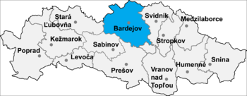
in Bardejov District
Bardejov District
Bardejov District is a district in the Prešov Region of eastern Slovakia.Until 1918, the district was part of the Hungarian county of...
in the Prešov Region
Prešov Region
The Prešov Region is one of the eight Slovak administrative regions. It consists of 13 districts.-Geography:It is located in north-eastern Slovakia and has an area of 8,975 km². The region has diverse types of landscapes occurring in Slovakia, but mostly highlands and hilly lands dominate the...
of north-east Slovakia
Slovakia
The Slovak Republic is a landlocked state in Central Europe. It has a population of over five million and an area of about . Slovakia is bordered by the Czech Republic and Austria to the west, Poland to the north, Ukraine to the east and Hungary to the south...
.
History
In the medieval times, Mokroluh was a vassal village and it belonged to the estate Smilno-Makovica. Since 1471 Mokroluh became a property of the city of Bardejov and during the times of Austro-Hungarian Monarchy village belonged to ŠarišŠariš
For the beer brand see Šariš .Šariš is the traditional name of a region situated in northeastern Slovakia. It encompasses the territory of the former Sáros county.-History:...
County.
The name of the village changed several times over the course of the centuries. In 1277 it was called Mokurlang, in 1320 Saarpotok, in 1773 Mokroluch, in 1920 Mokroluky and since 1972 Mokroluh. The oldest known seal of the village comes from the second half of the 19th century. It depicts a tree growing on the ground.
In the past Mokroluh was an agrarian village; its inhabitants worked the land, raised cattle and produced shingles
Shake (shingle)
A shake is a basic wooden shingle that is made from split logs. Shakes have traditionally been used for roofing and siding applications around the world. Higher grade shakes are typically used for roofing purposes, while the lower grades are used for siding purposes...
(sindle), spinning wheels
Spinning wheel
A spinning wheel is a device for spinning thread or yarn from natural or synthetic fibers. Spinning wheels appeared in Asia, probably in the 11th century, and very gradually replaced hand spinning with spindle and distaff...
(kolovratky), and wooden tools. The 1355 report mentions a village mill, confirming that the population grew cereals. In the 1330’ the first church was built in Mokroluh and it has its own pastor. At the end of the 16th century, Mokroluh was a medium–sized village with a vassal population only. The village was caught in a great fire in 1723; however shortly after the fire there were already 52 new homes built. Village artisans soon included blacksmiths and wheel makers. In the middle of the village on a relatively busy road, there was built a blacksmith and carriage workshop. It was a large building used for changing, resting and treating of the horses pulling carriages. The carriage workshop became popular among riders (rurman) because it was also an inn. A replica of Mokroluh’s carriage workshop today stands in the open–air museum in Svidnik.
There are only a few old buildings remaining in the village – the Roman Catholic Church from 1772, the chapel from 1826, and the Lutheran bell tower from 1933. Only a few original wooden houses have been preserved and are now slightly altered with revise and redesigned roofs. Several classic wood and clay storehouses (sypanec) today remain unchanged since they were constructed. Some of them were transformed into holiday cottages.
Present
Modern development began after the liberation of the village 20th January 1945. The citizens themselves repaired a destroyed bridge. Electricity was established in 1956 and in 1958 the first phone line was introduced. In 1959, a single agricultural cooperative (JRD) was created by force. On the foundation of the old carriage workshop a new culture house was built between 1948 and 1952. In the second half of the 1950’ a municipal cinema, library, and amateur theatre led by the local teachers were established there. Today, the cinema does not work, but the library is active, and so is a Mokroluzan folk group, which preserves folk music and dramas from the lives of our ancestors.
Geography
Mokroluh is situated 5 km to the west of BardejovBardejov
Bardejov is a town in North-Eastern Slovakia. It is situated in the Šariš region and has about 33,000 inhabitants. The spa town, mentioned for the first time in 1241, exhibits numerous cultural monuments in its completely intact medieval town center...
in the direction of Stara Lubovna
Stará Lubovna
Stará Ľubovňa is a town with approximately 16,000 inhabitants in northeastern Slovakia. The town consists of the districts Podsadek and Stará Ľubovňa.-Geography:...
and Poprad
Poprad
Poprad is a city in northern Slovakia at the foot of the High Tatra Mountains famous for its picturesque historic centre and as a holiday resort. It is the biggest town of the Spiš region and the tenth largest city in Slovakia with a population of approximately 55,000.The Poprad-Tatry Airport is...
in the valley of the river Topľa
Topla
Topla may refer to several villages in Romania, Serbia, or Montenegro:* Topla, a village in Bor District in Serbia* Topla monastery, near Herceg Novi* Topla, a village in Cornereva Commune, Caraş-Severin County...
in between the Čergov
Čergov
Čergov is a mountain range in the central part of the Prešov Region of Slovakia.Geologically the range is part of the Outer Western Carpathians, but may be classified as part of the Eastern Beskids, or classified as part of the Western Beskids...
and Low Beskids
Low Beskids
The ', ', Low Beskids or Lower Beskids is one of the Beskids mountain ranges in the Outer Eastern Carpathians in southeastern Poland and northeastern Slovakia...
mountain ranges.
The municipality
Municipality
A municipality is essentially an urban administrative division having corporate status and usually powers of self-government. It can also be used to mean the governing body of a municipality. A municipality is a general-purpose administrative subdivision, as opposed to a special-purpose district...
lies in an altitude
Altitude
Altitude or height is defined based on the context in which it is used . As a general definition, altitude is a distance measurement, usually in the vertical or "up" direction, between a reference datum and a point or object. The reference datum also often varies according to the context...
of 324 metres and covers an area
Area
Area is a quantity that expresses the extent of a two-dimensional surface or shape in the plane. Area can be understood as the amount of material with a given thickness that would be necessary to fashion a model of the shape, or the amount of paint necessary to cover the surface with a single coat...
of 7.947 km².
It has a population
Population
A population is all the organisms that both belong to the same group or species and live in the same geographical area. The area that is used to define a sexual population is such that inter-breeding is possible between any pair within the area and more probable than cross-breeding with individuals...
of about 715 people.
External links
- http://www.statistics.sk/mosmis/eng/run.html