

Mitsuke-juku
Encyclopedia
53 Stations of the Tokaido
The are the rest areas along the Tōkaidō, which was a coastal route that ran from Nihonbashi in Edo to Sanjō Ōhashi in Kyoto.-Stations of the Tōkaidō:...
of the Tōkaidō
Tokaido (road)
The ' was the most important of the Five Routes of the Edo period, connecting Edo to Kyoto in Japan. Unlike the inland and less heavily travelled Nakasendō, the Tōkaidō travelled along the sea coast of eastern Honshū, hence the route's name....
. It is located in what is now the central part of the city of Iwata
Iwata, Shizuoka
is a city located in Shizuoka, Japan and is known for being the headquarters of the Yamaha Motor Corporation. Iwata is also home to Júbilo Iwata, a J. League soccer team, as well as Yamaha Jubilo, a rugby team. The population was 170,779 as of March 1, 2010...
, Shizuoka Prefecture
Shizuoka Prefecture
is a prefecture of Japan located in the Chūbu region on Honshu island. The capital is the city of Shizuoka.- History :Shizuoka prefecture was formed from the former Tōtōmi, Suruga and Izu provinces.The area was the home of the first Tokugawa Shogun...
, Japan
Japan
Japan is an island nation in East Asia. Located in the Pacific Ocean, it lies to the east of the Sea of Japan, China, North Korea, South Korea and Russia, stretching from the Sea of Okhotsk in the north to the East China Sea and Taiwan in the south...
. The post station
Shukuba
were post stations during the Edo period in Japan, generally located on one of the Edo Five Routes or one of its sub-routes. They were also called shukueki . These post stations were places where travelers could rest on their journey around the nation...
received its name, which means "with a view," because it was the first place from which Mount Fuji
Mount Fuji
is the highest mountain in Japan at . An active stratovolcano that last erupted in 1707–08, Mount Fuji lies about south-west of Tokyo, and can be seen from there on a clear day. Mount Fuji's exceptionally symmetrical cone is a well-known symbol of Japan and it is frequently depicted in art and...
could be seen by travelers coming from Kyoto
Kyoto
is a city in the central part of the island of Honshū, Japan. It has a population close to 1.5 million. Formerly the imperial capital of Japan, it is now the capital of Kyoto Prefecture, as well as a major part of the Osaka-Kobe-Kyoto metropolitan area.-History:...
.
History
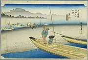
Mitsuke-juku is located on the left bank of the Tenryū RiverTenryu River
The is a river arising from Lake Suwa in Okaya, Nagano Prefecture, grazing Aichi Prefecture and flowing through western Shizuoka Prefecture in central Honshū, Japan. With a length of , it is Japan's ninth longest river.-Geography:...
, but boats generally used the nearby Ōi River
Oi River
The is a river in Shizuoka Prefecture, Japan.-Geography:The Ōi River flows from the Akaishi Mountains, the branch of the Japanese Southern Alps which form the border between Shizuoka, Nagano and Yamanashi prefectures. These mountains, with peaks ranging from 2000–3000 meters, are characterized by...
, as it had a deeper channel and fewer difficult places to navigate. However, much like Shimada-juku
Shimada-juku
was the twenty-third of the fifty-three stations of the Tōkaidō. It is located in what is now part of Shimada, Shizuoka Prefecture, Japan.-History:...
, whenever the Ōi River overflowed, travel through the town became impossible.
In addition to being a post station, Mitsuke-juku also flourished as the entry to Tōtōmi Province
Totomi Province
was a province of Japan in the area of Japan that is today western Shizuoka Prefecture. Tōtōmi bordered on Mikawa, Suruga and Shinano Provinces. Its abbreviated form name was .-History:...
's and as the point at which the Tōkaidō separated with a hime kaidō
Hime kaido
was the name given to minor routes that created detours around the difficult crossings of main routes during the Edo period in Japan...
.
When the Tōkaidō Main Line
Tokaido Main Line
The is the busiest trunk line of the Japan Railways Group , connecting Tōkyō and Kōbe stations. It is long, not counting its many freight feeder lines around the major cities...
railway was established, the train station was built to the south of Mitsuke in the village of Nakaizumi. In 1940, Mistuke and Nakaizumi merged, forming the town of Iwata, which became a city in 1948.
The classic ukiyoe print by Ando Hiroshige (Hoeido edition) from 1831-1834 depicts travelers changing boats on a sandbank while crossing the Tenryū River by ferry.
Further reading
- Carey, Patrick. Rediscovering the Old Tokaido:In the Footsteps of Hiroshige. Global Books UK (2000). ISBN 1901903109
- Chiba, Reiko. Hiroshige's Tokaido in Prints and Poetry. Tuttle. (1982) ISBN 0804802467
- Taganau, Jilly. The Tokaido Road: Travelling and Representation in Edo and Meiji Japan. RoutledgeCurzon (2004). ISBN 0415310911