

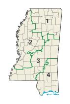
Mississippi's congressional districts
Encyclopedia
U.S. state
A U.S. state is any one of the 50 federated states of the United States of America that share sovereignty with the federal government. Because of this shared sovereignty, an American is a citizen both of the federal entity and of his or her state of domicile. Four states use the official title of...
of Mississippi
Mississippi
Mississippi is a U.S. state located in the Southern United States. Jackson is the state capital and largest city. The name of the state derives from the Mississippi River, which flows along its western boundary, whose name comes from the Ojibwe word misi-ziibi...
currently has four congressional districts. In the 112th Congress
112th United States Congress
The One Hundred Twelfth United States Congress is the current meeting of the legislative branch of the United States federal government, composed of the United States Senate and the United States House of Representatives. It convened in Washington, D.C. on January 3, 2011, and will end on January...
, the Mississippi delegation
United States Congressional Delegations from Mississippi
These are tables of congressional delegations from Mississippi to the United States Senate and United States House of Representatives.-United States Senate:-United States House of Representatives:-1801 - 1817: 1 non-voting delegate:...
consists of one Democrats
Democratic Party (United States)
The Democratic Party is one of two major contemporary political parties in the United States, along with the Republican Party. The party's socially liberal and progressive platform is largely considered center-left in the U.S. political spectrum. The party has the lengthiest record of continuous...
and three Republican
Republican Party (United States)
The Republican Party is one of the two major contemporary political parties in the United States, along with the Democratic Party. Founded by anti-slavery expansion activists in 1854, it is often called the GOP . The party's platform generally reflects American conservatism in the U.S...
.
Apportionment history
From 1789 to 1817, the Mississippi TerritoryMississippi Territory
The Territory of Mississippi was an organized incorporated territory of the United States that existed from April 7, 1798, until December 10, 1817, when the final extent of the territory was admitted to the Union as the state of Mississippi....
was represented in Congress
United States Congress
The United States Congress is the bicameral legislature of the federal government of the United States, consisting of the Senate and the House of Representatives. The Congress meets in the United States Capitol in Washington, D.C....
by a non-voting delegate
Delegate (United States Congress)
A delegate to Congress is a non-voting member of the United States House of Representatives who is elected from a U.S. territory and from Washington, D.C. to a two-year term. While unable to vote in the full House, a non-voting delegate may vote in a House committee of which the delegate is a member...
. Since becoming a state on December 10, 1817, Mississippi has sent between one and eight representatives to Congress.
| 1817 1 | 1820 | 1830 | 1840 | 1850 |
|---|---|---|---|---|
| 1 | 1 | 2 | 4 | 5 |
| 1860 | 1870 | 1880 | 1890 | 1900 |
|---|---|---|---|---|
| 5 | 6 | 7 | 7 | 8 |
| 1910 | 1920 | 1930 | 1940 | 1950 |
|---|---|---|---|---|
| 8 | 8 | 7 | 7 | 6 |
| 1960 | 1970 | 1980 | 1990 | 2000 |
|---|---|---|---|---|
| 5 | 5 | 5 | 5 | 4 |
- Mississippi was granted statehood on December 10, 1817.
1st District
The first congressional district covers northern and northeastern portions of Mississippi. It includes all of AlcornAlcorn County, Mississippi
There were 14,224 households out of which 30.90% had children under the age of 18 living with them, 54.50% were married couples living together, 11.50% had a female householder with no husband present, and 30.30% were non-families. 27.60% of all households were made up of individuals and 11.90% had...
, Benton
Benton County, Mississippi
-Demographics:At the 2000 census, there were 8,026 people, 2,999 households and 2,216 families residing in the county. The population density was 20 per square mile . There were 3,456 housing units at an average density of 8 per square mile...
, Calhoun
Calhoun County, Mississippi
Calhoun County is a county located in the U.S. state of Mississippi. As of 2010, the population was 14,962. Its county seat is Pittsboro. Calhoun County is named after John C. Calhoun, the U.S. Vice President and U.S...
, Chickasaw
Chickasaw County, Mississippi
-National protected areas:* Natchez Trace Parkway * Tombigbee National Forest -Demographics:As of the census of 2000, there were 19,440 people, 7,253 households, and 5,287 families residing in the county. The population density was 39 people per square mile . There were 7,981 housing units at an...
, Choctaw
Choctaw County, Mississippi
-National protected areas:* Natchez Trace Parkway * Tombigbee National Forest -Demographics:As of the census of 2000, there were 9,758 people, 3,686 households, and 2,668 families residing in the county. The population density was 23 people per square mile . There were 4,249 housing units at an...
, Clay
Clay County, Mississippi
As of the census of 2000, there were 21,979 people, 8,152 households, and 5,885 families residing in the county. The population density was 54 people per square mile . There were 8,810 housing units at an average density of 22 per square mile...
, DeSoto
DeSoto County, Mississippi
-Demographics:As of the census of 2005 estimate, there were 137,004 people, 38,792 households, and 30,102 families residing in the county. The population density was 224 people per square mile . There were 40,795 housing units at an average density of 85 per square mile...
, Grenada
Grenada County, Mississippi
-Demographics:As of the census of 2000, there were 23,263 people, 8,820 households, and 6,297 families residing in the county. The population density was 55 people per square mile . There were 9,973 housing units at an average density of 24 per square mile...
, Itawamba
Itawamba County, Mississippi
In 2000, there were 8,773 households out of which 33.20% had children under the age of 18 living with them, 60.30% were married couples living together, 9.90% had a female householder with no husband present, and 25.90% were non-families. 23.40% of all households were made up of individuals and...
, Lafayette
Lafayette County, Mississippi
-Demographics:As of the census of 2000, there were 38,744 people, 14,373 households, and 8,321 families residing in the county. The population density was 61 people per square mile . There were 16,587 housing units at an average density of 26 per square mile...
, Lee
Lee County, Mississippi
-National protected areas:* Brices Cross Roads National Battlefield Site* Natchez Trace Parkway * Tupelo National Battlefield-History:On September 20, 1816, General Andrew Jackson, David Meriwether, and the Chickasaw Nation signed the Treaty of Chickasaw Council House in Lee County.Lee County was...
, Lowndes
Lowndes County, Mississippi
As of the census of 2000, there were 61,586 people, 22,849 households, and 16,405 families residing in the county. The population density was 123 people per square mile . There were 25,104 housing units at an average density of 50 per square mile...
, Marshall
Marshall County, Mississippi
-Demographics:At the 2000 census, there were 34,993 people, 12,163 households and 9,110 families residing in the county. The population density was 50 per square mile . There were 13,252 housing units at an average density of 19 per square mile...
, Monroe
Monroe County, Mississippi
-Demographics:As of the census of 2000, there were 38,014 people, 14,603 households, and 10,660 families residing in the county. The population density was 50 people per square mile . There were 16,236 housing units at an average density of 21 per square mile...
, Panola
Panola County, Mississippi
-Demographics:As of the census of 2000, there were 34,274 people, 12,232 households, and 9,014 families residing in the county. The population density was 50 people per square mile . There were 13,736 housing units at an average density of 20 per square mile...
, Pontotoc
Pontotoc County, Mississippi
-National protected area:* Natchez Trace Parkway * Tombigbee National Forest -Demographics:As of the census of 2000, there were 26,726 people, 10,097 households, and 7,562 families residing in the county. The population density was 54 people per square mile . There were 10,816 housing units at an...
, Prentiss
Prentiss County, Mississippi
-Demographics:As of the census of 2000, there were 25,556 people, 9,821 households, and 7,169 families residing in the county. The population density was 62 people per square mile . There were 10,681 housing units at an average density of 26 per square mile...
, Tate
Tate County, Mississippi
-Demographics:As of the census of 2000, there were 25,370 people, 8,850 households, and 6,717 families residing in the county. The population density was 63 people per square mile . There were 9,354 housing units at an average density of 23 per square mile...
, Tippah
Tippah County, Mississippi
-Demographics:At the 2000 census, there are 20,826 people, 8,108 households and 5,910 families residing in the county. The population density was 46 per square mile . There were 8,868 housing units at an average density of 19 per square mile...
, Tishomingo
Tishomingo County, Mississippi
As of the census of 2000 there were 19,163 people, 7,917 households, and 5,573 families residing in the county. The population density was 45 people per square mile . There were 9,553 housing units at an average density of 22 per square mile...
, Union
Union County, Mississippi
-Demographics:As of the census of 2000, there were 25,362 people, 9,786 households, and 7,241 families residing in the county. The population density was 61 people per square mile . There were 10,693 housing units at an average density of 26 per square mile...
, and Yalobusha
Yalobusha County, Mississippi
Yalobusha County is a county located in the U.S. state of Mississippi. As of 2010, the population was 12,678. Its county seats are Water Valley and Coffeeville.-History:...
counties, most of Webster County
Webster County, Mississippi
-Demographics:As of the census of 2000, there were 10,294 people, 3,905 households, and 2,877 families residing in the county. The population density was 24 people per square mile . There were 4,344 housing units at an average density of 10 per square mile...
, and a small portion of Winston County
Winston County, Mississippi
-Demographics:At the 2000 census, there were 20,160 people, 7,578 households and 5,471 families residing in the county. The population density was 33 per square mile . There were 8,472 housing units at an average density of 14 per square mile...
.
Large cities in the district include Southaven
Southaven, Mississippi
-Households And Families:As of the census of 2000, there were 28,977 people, 11,007 households, and 8,134 families residing in the city. The population density was 857.9 people per square mile...
, Tupelo
Tupelo, Mississippi
Tupelo is the largest city in and the county seat of Lee County, Mississippi, United States. It is the seventh largest city in the state of Mississippi, smaller than Meridian, and larger than Greenville. As of the 2000 United States Census, the city's population was 34,211...
, Olive Branch
Olive Branch, Mississippi
Olive Branch is a city in DeSoto County, Mississippi, United States. The population was 21,054 at the 2000 census. A July 1, 2008 United States Census Bureau estimate placed the population at 31,830, making it the ninth-largest city in the state of Mississippi...
, Columbus
Columbus, Mississippi
Columbus is a city in Lowndes County, Mississippi, United States that lies above the Tombigbee River. It is approximately northeast of Jackson, north of Meridian, south of Tupelo, northwest of Tuscaloosa, Alabama, and west of Birmingham, Alabama. The population was 25,944 at the 2000 census...
, Horn Lake
Horn Lake, Mississippi
Horn Lake is a city in DeSoto County, Mississippi, United States. Horn Lake is a suburb of Memphis, Tennessee, which is located just a few miles to the north. As of the 2000 U.S...
, and Oxford
Oxford, Mississippi
Oxford is a city in, and the county seat of, Lafayette County, Mississippi, United States. Founded in 1835, it was named after the British university city of Oxford in hopes of having the state university located there, which it did successfully attract....
.
This district is represented by Republican Alan Nunnelee.
2nd District
The second congressional district covers most of the largely rural Mississippi DeltaMississippi Delta
The Mississippi Delta is the distinctive northwest section of the U.S. state of Mississippi that lies between the Mississippi and Yazoo Rivers. The region has been called "The Most Southern Place on Earth" because of its unique racial, cultural, and economic history...
region as well as most of Jackson
Jackson, Mississippi
Jackson is the capital and the most populous city of the US state of Mississippi. It is one of two county seats of Hinds County ,. The population of the city declined from 184,256 at the 2000 census to 173,514 at the 2010 census...
, the state capital. The state's only African American
African American
African Americans are citizens or residents of the United States who have at least partial ancestry from any of the native populations of Sub-Saharan Africa and are the direct descendants of enslaved Africans within the boundaries of the present United States...
-majority district, it includes all of Attala
Attala County, Mississippi
-Demographics:As of the census of 2000, there were 19,661 people, 7,567 households, and 5,380 families residing in the county. The population density was 27 people per square mile . There were 8,639 housing units at an average density of 12 per square mile...
, Bolivar
Bolivar County, Mississippi
-Demographics:As of the census of 2000, there were 40,633 people, 13,776 households, and 9,725 families residing in the county. The population density was 46 people per square mile . There were 14,939 housing units at an average density of 17 per square mile...
, Carroll
Carroll County, Mississippi
-Demographics:As of the census of 2000, there were 10,769 people, 4,071 households, and 3,069 families residing in the county. The population density was 17 people per square mile . There were 4,888 housing units at an average density of 8 per square mile...
, Claiborne
Claiborne County, Mississippi
-Demographics:As of the census of 2000, there were 11,831 people, 3,685 households, and 2,531 families residing in the county. The population density was 24 people per square mile . There were 4,252 housing units at an average density of 9 per square mile...
, Coahoma
Coahoma County, Mississippi
-Demographics:As of the census of 2000, there were 30,622 people, 10,553 households, and 7,482 families residing in the county. The population density was 55 people per square mile . There were 11,490 housing units at an average density of 21 per square mile...
, Copiah
Copiah County, Mississippi
As of the census of 2000, there were 28,757 people, 10,142 households, and 7,494 families residing in the county. The population density was 37 people per square mile . There were 11,101 housing units at an average density of 14 per square mile...
, Holmes County
Holmes County, Mississippi
-National protected areas:*Hillside National Wildlife Refuge *Mathews Brake National Wildlife Refuge *Morgan Brake National Wildlife Refuge*Theodore Roosevelt National Wildlife Refuge -Demographics:...
, Humphreys
Humphreys County, Mississippi
-Demographics:At the 2000 census, there were 11,206 people, 3,765 households and 2,695 families residing in the county. The population density was 27 per square mile . There were 4,138 housing units at an average density of 10 per square mile...
, Issaquena
Issaquena County, Mississippi
-Demographics:As of the census of 2000, there were 2,274 people, 726 households, and 509 families residing in the county. The population density was 5.15 people per square mile . There were 877 housing units at an average density of 2 per square mile...
, Jefferson
Jefferson County, Mississippi
-National protected areas:* Homochitto National Forest * Natchez Trace Parkway -Demographics:As of the census of 2000, there were 9,740 people, 3,308 households, and 2,338 families residing in the county. The population density was 19 people per square mile . There were 3,819 housing units at an...
, Leflore
Leflore County, Mississippi
-National protected area:*Mathews Brake National Wildlife Refuge*Theodore Roosevelt National Wildlife Refuge -Demographics:As of the census of 2000, there were 37,947 people, 12,956 households, and 8,887 families residing in the county. The population density was 64 people per square mile...
, Montgomery
Montgomery County, Mississippi
-Demographics:As of the census of 2000, there were 12,189 people, 4,690 households, and 3,367 families residing in the county. The population density was 30 people per square mile . There were 5,402 housing units at an average density of 13 per square mile...
, Quitman
Quitman County, Mississippi
-Demographics:As of the census of 2000, there were 10,117 people, 3,565 households, and 2,506 families residing in the county. The population density was 25 people per square mile . There were 3,923 housing units at an average density of 10 per square mile...
, Sharkey
Sharkey County, Mississippi
-National protected area:*Delta National Forest*Theodore Roosevelt National Wildlife Refuge -Demographics:As of the census of 2000, there were 6,580 people, 2,163 households, and 1,589 families residing in the county. The population density was 15 people per square mile . There were 2,416 housing...
, Sunflower
Sunflower County, Mississippi
-Demographics:As of the census of 2000, there were 34,369 people, 9,637 households, and 7,314 families residing in the county. The population density was 50 people per square mile . There were 10,338 housing units at an average density of 15 per square mile...
, Tallahatchie
Tallahatchie County, Mississippi
-National protected areas:*Coldwater River National Wildlife Refuge *Tallahatchie National Wildlife Refuge -Demographics:As of the census of 2000, there were 14,903 people, 5,263 households, and 3,826 families residing in the county. The population density was 23 people per square mile...
, Tunica
Tunica County, Mississippi
As of the census of 2000, there were 9,227 people, 3,258 households, and 2,192 families residing in the county. The population density was 20 people per square mile . There were 3,705 housing units at an average density of 8 per square mile...
, Warren
Warren County, Mississippi
-National protected areas:* Theodore Roosevelt National Wildlife Refuge * Vicksburg National Military Park -Demographics:As of the census of 2000, there were 49,644 people, 18,756 households, and 13,222 families residing in the county. The population density was 85 people per square mile...
, Washington
Washington County, Mississippi
-National protected areas:*Holt Collier National Wildlife Refuge*Theodore Roosevelt National Wildlife Refuge *Yazoo National Wildlife Refuge-Demographics:...
, and Yazoo
Yazoo County, Mississippi
-National protected area:*Hillside National Wildlife Refuge *Panther Swamp National Wildlife Refuge-History:The area which is now Yazoo County was acquired by the State of Mississippi from the Choctaw Indians in 1820. Yazoo County was established on January 21, 1823. It was the 19th county...
counties. Most of Hinds
Hinds County, Mississippi
As of the census of 2000, there were 250,800 people, 91,030 households, and 62,355 families residing in the county. The population density was 288 people per square mile . There were 100,287 housing units at an average density of 115 per square mile...
, Leake
Leake County, Mississippi
-Demographics:As of the census of 2000, there were 20,940 people, 7,611 households, and 5,563 families residing in the county. The population density was 36 people per square mile . There were 8,585 housing units at an average density of 15 per square mile...
, and Madison
Madison County, Mississippi
-Demographics:As of the census of 2000, there were 74,674 people, 27,219 households, and 19,325 families residing in the county. The population density was 104 people per square mile . There were 28,781 housing units at an average density of 40 per square mile...
counties also lie within the second district.
In addition to Jackson, other large cities in the district include Greenville
Greenville, Mississippi
Greenville is a city in Washington County, Mississippi, United States. The population was 48,633 at the 2000 census, but according to the 2009 census bureau estimates, it has since declined to 42,764, making it the eighth-largest city in the state. It is the county seat of Washington...
, Vicksburg
Vicksburg, Mississippi
Vicksburg is a city in Warren County, Mississippi, United States. It is the only city in Warren County. It is located northwest of New Orleans on the Mississippi and Yazoo rivers, and due west of Jackson, the state capital. In 1900, 14,834 people lived in Vicksburg; in 1910, 20,814; in 1920,...
, Clinton
Clinton, Mississippi
Clinton is a city in Hinds County, Mississippi, United States. Situated in the Jackson metropolitan area, it is the tenth largest city in Mississippi. The population was 23,347 at the 2000 United States Census.-History:...
, Greenwood
Greenwood, Mississippi
Greenwood is a city in and the county seat of Leflore County, Mississippi, United States, located at the eastern edge of the Mississippi Delta approximately 96 miles north of Jackson, Mississippi, and 130 miles south of Memphis, Tennessee. The population was 15,205 at the 2010 census. It is the...
, and Clarksdale
Clarksdale, Mississippi
Clarksdale is a city in Coahoma County, Mississippi, United States. The population was 20,645 at the 2000 census. It is the county seat of Coahoma County....
.
The district has been represented by Democrat
Democratic Party (United States)
The Democratic Party is one of two major contemporary political parties in the United States, along with the Republican Party. The party's socially liberal and progressive platform is largely considered center-left in the U.S. political spectrum. The party has the lengthiest record of continuous...
Bennie Thompson
Bennie Thompson
Bennie G. Thompson, is the U.S. Representative for , serving since 1993, and the ranking member of the Committee on Homeland Security since 2011. He is a member of the Democratic Party....
since 1993.
3rd District
The third congressional district covers central Mississippi and stretches from the LouisianaLouisiana
Louisiana is a state located in the southern region of the United States of America. Its capital is Baton Rouge and largest city is New Orleans. Louisiana is the only state in the U.S. with political subdivisions termed parishes, which are local governments equivalent to counties...
border in the west to the Alabama
Alabama
Alabama is a state located in the southeastern region of the United States. It is bordered by Tennessee to the north, Georgia to the east, Florida and the Gulf of Mexico to the south, and Mississippi to the west. Alabama ranks 30th in total land area and ranks second in the size of its inland...
border in the east. It includes all of Adams
Adams County, Mississippi
As of the census of 2000, there were 34,340 people, 13,677 households, and 9,409 families residing in the county. The population density was 75 people per square mile . There were 15,175 housing units at an average density of 33 per square mile...
, Amite
Amite County, Mississippi
-Demographics:As of the census of 2000, there were 13,599 people, 5,271 households, and 3,879 families residing in the county. The population density was 19 people per square mile . There were 6,446 housing units at an average density of 9 per square mile...
, Covington
Covington County, Mississippi
-2010 Census:As of the most recent census, 2010, the population of Covington County is 19,568, only a slight increase from 2000. Racially, the population was distributed with 62.7% being White, 34.7% Black/African American, 1.9% Hispanic/Latino, 0.2% Asian, 0.1% American Indian/Alaskan Native, and...
, Franklin
Franklin County, Mississippi
-Demographics:As of the census of 2000, there were 8,448 people, 3,211 households, and 2,337 families residing in the county. The population density was 15 people per square mile . There were 4,119 housing units at an average density of 7 per square mile...
, Jefferson Davis
Jefferson Davis County, Mississippi
-Demographics:As of the census of 2000, there were 13,962 people, 5,177 households, and 3,768 families residing in the county. The population density was 34 people per square mile . There were 5,891 housing units at an average density of 14 per square mile...
, Kemper
Kemper County, Mississippi
-Demographics:As of the census of 2000, there were 10,453 people, 3,909 households, and 2,787 families residing in the county. The population density was 14 people per square mile . There were 4,533 housing units at an average density of 6 per square mile...
, Lauderdale
Lauderdale County, Mississippi
-Demographics:As of the census of 2000, there were 78,161 people, 29,990 households, and 20,573 families residing in the county. The population density was 111 people per square mile . There were 33,418 housing units at an average density of 48 per square mile...
, Lawrence
Lawrence County, Mississippi
Lawrence County is a county located in the U.S. state of Mississippi. As of 2010, the population was 12,929. Its county seat is Monticello. Lawrence County is named for the naval hero James Lawrence.-Geography:...
, Lincoln
Lincoln County, Mississippi
-Demographics:As of the census of 2000, there were 33,166 people, 12,538 households, and 9,190 families residing in the county. The population density was 57 people per square mile . There were 14,052 housing units at an average density of 24 per square mile...
, Neshoba
Neshoba County, Mississippi
-Demographics:As of the census of 2000, there were 28,684 people, 10,694 households, and 7,742 families residing in the county. The population density was 50 people per square mile . There were 11,980 housing units at an average density of 21 per square mile...
, Newton
Newton County, Mississippi
-History:Newton County was formed in 1836. All sources say it was named in honor of Sir Isaac Newton, including the 1896 history of Newton County.Newton County is adjacent to Jasper County, which was named for Sgt. William Jasper, a Revolutionary War hero of the Siege of Savannah in 1779. Sgt. John...
, Noxubee
Noxubee County, Mississippi
-Demographics:As of the census of 2000, there were 12,548 people, 4,470 households, and 3,222 families residing in the county. The population density was 18 people per square mile . There were 5,228 housing units at an average density of 8 per square mile...
, Oktibbeha
Oktibbeha County, Mississippi
-National protected areas:*Noxubee National Wildlife Refuge *Tombigbee National Forest -Demographics:As of the census of 2000, there were 42,902 people, 15,945 households, and 9,264 families residing in the county. The population density was 94 people per square mile . There were 17,344 housing...
, Pike
Pike County, Mississippi
-Demographics:As of the census of 2000, there were 38,940 people, 14,792 households, and 10,502 families residing in the county. The population density was 95 people per square mile . There were 16,720 housing units at an average density of 41 per square mile...
, Rankin
Rankin County, Mississippi
-Demographics:As of the census of 2000, there were 115,327 people, 42,089 households, and 31,145 families residing in the county. The population density was 149 people per square mile . There were 45,070 housing units at an average density of 58 per square mile...
, Scott
Scott County, Mississippi
-Demographics:As of the census of 2000, there were 28,423 people, 10,183 households, and 7,535 families residing in the county. The population density was 47 people per square mile . There were 11,116 housing units at an average density of 18 per square mile...
, Simpson
Simpson County, Mississippi
-Demographics:As of the census of 2000, there were 27,639 people, 10,076 households, and 7,385 families residing in the county. The population density was 47 people per square mile . There were 11,307 housing units at an average density of 19 per square mile...
, Smith
Smith County, Mississippi
-Demographics:As of the census of 2000, there were 16,182 people, 6,046 households, and 4,558 families residing in the county. The population density was 25 people per square mile . There were 7,005 housing units at an average density of 11 per square mile...
, Walthall
Walthall County, Mississippi
-Demographics:As of the census of 2000, there were 15,156 people, 5,571 households, and 4,111 families residing in the county. The population density was 38 people per square mile . There were 6,418 housing units at an average density of 16 per square mile...
, and Wilkinson
Wilkinson County, Mississippi
-Demographics:As of the census of 2000, there were 10,312 people, 3,578 households, and 2,511 families residing in the county. The population density was 15 people per square mile . There were 5,106 housing units at an average density of 8 per square mile...
counties. Most of Winston County
Winston County, Mississippi
-Demographics:At the 2000 census, there were 20,160 people, 7,578 households and 5,471 families residing in the county. The population density was 33 per square mile . There were 8,472 housing units at an average density of 14 per square mile...
and portions of Hinds
Hinds County, Mississippi
As of the census of 2000, there were 250,800 people, 91,030 households, and 62,355 families residing in the county. The population density was 288 people per square mile . There were 100,287 housing units at an average density of 115 per square mile...
, Jasper
Jasper County, Mississippi
-History:Jasper County was formed in 1833 from the middle section of what been Jones County. It was named for Sgt. William Jasper who first distinguished himself in the defense of Fort Moultrie in 1776. When a shell from a British warship shot away the flagstaff, he recovered the flag, raised it on...
, Jones
Jones County, Mississippi
-History:Jones County, formed out parts of Covington and Wayne counties, was established on January 24, 1826 and was named for John Paul Jones. There are other counties named Jones, but it appears that this is the only one named for John Paul Jones...
, Leake
Leake County, Mississippi
-Demographics:As of the census of 2000, there were 20,940 people, 7,611 households, and 5,563 families residing in the county. The population density was 36 people per square mile . There were 8,585 housing units at an average density of 15 per square mile...
, Madison
Madison County, Mississippi
-Demographics:As of the census of 2000, there were 74,674 people, 27,219 households, and 19,325 families residing in the county. The population density was 104 people per square mile . There were 28,781 housing units at an average density of 40 per square mile...
, Marion
Marion County, Mississippi
-Demographics:As of the census of 2000, there were 25,595 people, 9,336 households, and 6,880 families residing in the county. The population density was 47 people per square mile . There were 10,395 housing units at an average density of 19 per square mile...
, and Webster
Webster County, Mississippi
-Demographics:As of the census of 2000, there were 10,294 people, 3,905 households, and 2,877 families residing in the county. The population density was 24 people per square mile . There were 4,344 housing units at an average density of 10 per square mile...
counties also lie within the third district.
Large cities in the district include Meridian
Meridian, Mississippi
Meridian is the county seat of Lauderdale County, Mississippi. It is the sixth largest city in the state and the principal city of the Meridian, Mississippi Micropolitan Statistical Area...
, Starkville
Starkville, Mississippi
-Demographics:As of the census of 2000, there were 21,869 people, 9,462 households, and 4,721 families residing in the city. The population density was 851.4 people per square mile . There were 10,191 housing units at an average density of 396.7 per square mile...
, Pearl
Pearl, Mississippi
Pearl is a city in Rankin County, Mississippi, United States. The population was 21,961 at the 2000 census. It is part of the Jackson Metropolitan Statistical Area....
, and Natchez
Natchez, Mississippi
Natchez is the county seat of Adams County, Mississippi, United States. With a total population of 18,464 , it is the largest community and the only incorporated municipality within Adams County...
. A portion of the city of Jackson
Jackson, Mississippi
Jackson is the capital and the most populous city of the US state of Mississippi. It is one of two county seats of Hinds County ,. The population of the city declined from 184,256 at the 2000 census to 173,514 at the 2010 census...
is in the third district.
The district has been represented by Republican
Republican Party (United States)
The Republican Party is one of the two major contemporary political parties in the United States, along with the Democratic Party. Founded by anti-slavery expansion activists in 1854, it is often called the GOP . The party's platform generally reflects American conservatism in the U.S...
Gregg Harper
Gregg Harper
Gregory "Gregg" Harper is the U.S. Representative for , serving since 2009. He is a member of the Republican Party. The district includes the wealthier portions of the state capital, Jackson, along with most of that city's suburbs. Other cities in the district include Meridian and Natchez.-...
since 2009.
4th District
The fourth congressional district covers the Gulf CoastMississippi Gulf Coast
The Mississippi Gulf Coast refers to the three Mississippi counties which lie on the Gulf of Mexico: Hancock, Harrison and Jackson counties.The region was severely damaged by Hurricane Camille in 1969 and again by Hurricane Katrina in 2005....
region as well as most of the Pine Belt
Pine Belt (Mississippi)
The Pine Belt, also known as the "Piney Woods", is a region in Southeast Mississippi. The region gets its name from the longleaf pine trees that are abundant in the region.- Geography :The Longleaf Pine belt covers 36 counties in Mississippi...
region in southeastern Mississippi. It includes all of Hancock
Hancock County, Mississippi
-Demographics:As of the census of 2000, there were 42,967 people, 16,897 households, and 11,827 families residing in the county. The population density was 90 people per square mile . There were 21,072 housing units at an average density of 44 per square mile...
, Harrison
Harrison County, Mississippi
-National protected areas:* De Soto National Forest * Gulf Islands National Seashore - Demographics :As of the census of 2000, there were 189,601 people, 71,538 households, and 48,574 families residing in the county. The population density was 326 people per square mile . There were 79,636 housing...
, Jackson
Jackson County, Mississippi
There were 47,676 households out of which 37.00% had children under the age of 18 living with them, 55.70% were married couples living together, 14.50% had a female householder with no husband present, and 25.10% were non-families. 20.80% of all households were made up of individuals and 7.10% had...
, Pearl River
Pearl River County, Mississippi
-National protected areas:*Bogue Chitto National Wildlife Refuge *De Soto National Forest -Demographics:The census estimates of 2006 place the county population over 57,000 and place it among the 10 fastest growing counties in the U.S. As of the census of 2000, there were 48,621 people, 18,078...
, Stone
Stone County, Mississippi
As of the census of 2000, there were 13,622 people, 4,747 households, and 3,626 families residing in the county. The population density was 31 people per square mile . There were 5,343 housing units at an average density of 12 per square mile...
, George
George County, Mississippi
-Demographics:As of the census of 2000, there were 19,144 people, 6,742 households, and 5,305 families residing in the county. The population density was 40 people per square mile . There were 7,513 housing units at an average density of 16 per square mile...
, Lamar
Lamar County, Mississippi
-Demographics:As of the census of 2000, there were 39,070 people, 14,396 households, and 10,725 families residing in the county. The population density was 79 people per square mile . There were 15,433 housing units at an average density of 31 per square mile...
, Forrest
Forrest County, Mississippi
The median income for a household in the county was $27,420, and the median income for a family was $35,791. Males had a median income of $28,742 versus $20,500 for females. The per capita income for the county was $15,160...
, Perry
Perry County, Mississippi
-Demographics:As of the census of 2000, there were 12,138 people, 4,420 households, and 3,332 families residing in the county. The population density was 19 people per square mile . There were 5,107 housing units at an average density of 8 per square mile...
, Greene
Greene County, Mississippi
-Demographics:As of the census of 2000, there were 13,299 people, 4,148 households, and 3,152 families residing in the county. The population density was 19 people per square mile . There were 4,947 housing units at an average density of 7 per square mile...
, Wayne
Wayne County, Mississippi
-Demographics:As of the census of 2000, there were 21,216 people, 7,857 households, and 5,853 families residing in the county. The population density was 26 people per square mile . There were 9,049 housing units at an average density of 11 per square mile...
, and Clarke
Clarke County, Mississippi
-Demographics:As of the census of 2000, there were 17,955 people, 6,978 households, and 5,024 families residing in the county. The population density was 26 people per square mile . There were 8,100 housing units at an average density of 12 per square mile...
counties. Most of Jones County
Jones County, Mississippi
-History:Jones County, formed out parts of Covington and Wayne counties, was established on January 24, 1826 and was named for John Paul Jones. There are other counties named Jones, but it appears that this is the only one named for John Paul Jones...
, and portions of both Jasper
Jasper County, Mississippi
-History:Jasper County was formed in 1833 from the middle section of what been Jones County. It was named for Sgt. William Jasper who first distinguished himself in the defense of Fort Moultrie in 1776. When a shell from a British warship shot away the flagstaff, he recovered the flag, raised it on...
and Marion
Marion County, Mississippi
-Demographics:As of the census of 2000, there were 25,595 people, 9,336 households, and 6,880 families residing in the county. The population density was 47 people per square mile . There were 10,395 housing units at an average density of 19 per square mile...
counties also lie within the district.
Large cities in the district include Gulfport
Gulfport, Mississippi
Gulfport is the second largest city in Mississippi after the state capital Jackson. It is the larger of the two principal cities of the Gulfport-Biloxi, Mississippi Metropolitan Statistical Area, which is included in the Gulfport-Biloxi-Pascagoula, Mississippi Combined Statistical Area. As of the...
, Biloxi
Biloxi, Mississippi
Biloxi is a city in Harrison County, Mississippi, in the United States. The 2010 census recorded the population as 44,054. Along with Gulfport, Biloxi is a county seat of Harrison County....
, Hattiesburg
Hattiesburg, Mississippi
Hattiesburg is a city in Forrest County, Mississippi, United States. The population was 44,779 at the 2000 census . It is the county seat of Forrest County...
, Pascagoula
Pascagoula, Mississippi
Pascagoula is a city in Jackson County, Mississippi, United States. It is the principal city of the Pascagoula, Mississippi Metropolitan Statistical Area, as a part of the Gulfport–Biloxi–Pascagoula, Mississippi Combined Statistical Area. The population was 26,200 at the 2000 census...
, Laurel
Laurel, Mississippi
Laurel is a city located in Jones County in Mississippi, a state of the United States of America. As of the 2000 census, the city had a total population of 18,393 although a significant population increase has been reported following Hurricane Katrina. Located in southeast Mississippi, southeast of...
, and Bay St. Louis
Bay St. Louis, Mississippi
Bay Saint Louis is a city located in Hancock County, Mississippi. It is part of the Gulfport–Biloxi, Mississippi Metropolitan Statistical Area. As of the 2000 census, the city had a total population of 8,209. It is the county seat of Hancock County...
.
Republican Steven Palazzo
Steven Palazzo
Steven McCarty Palazzo is the U.S. Representative for . The district takes in most of Mississippi's share of the Gulf Coast and includes Biloxi, Gulfport, Pascagoula, Laurel and Hattiesburg. He is a member of the Republican Party. He defeated 10-term Democratic incumbent Gene Taylor with 52% to...
has represented this district since 2011.
At-large District
Mississippi's At-large congressional district existed from the granting of statehood in 1817 to 1847 and again from 1853 to 1855.5th District
The fifth congressional district was created after the 1850 censusUnited States Census, 1850
The United States Census of 1850 was the seventh census of the United States. Conducted by the Bureau of the Census on June 1, 1850, it determined the resident population of the United States to be 23,191,876 — an increase of 35.9 percent over the 17,069,453 persons enumerated during the 1840...
and abolished following the 2000 census
United States Census, 2000
The Twenty-second United States Census, known as Census 2000 and conducted by the Census Bureau, determined the resident population of the United States on April 1, 2000, to be 281,421,906, an increase of 13.2% over the 248,709,873 persons enumerated during the 1990 Census...
.
6th District
The sixth congressional district was created after the 1870 censusUnited States Census, 1870
The United State Census of 1870 was the ninth United States Census. Conducted by the Census Bureau in June 1870, the 1870 Census was the first census to provide detailed information on the black population, only years after the culmination of the Civil War when slaves were granted freedom. The...
and abolished following the 1960 census
United States Census, 1960
The Eighteenth United States Census, conducted by the Census Bureau, determined the resident population of the United States to be 179,323,175, an increase of 18.5 percent over the 151,325,798 persons enumerated during the 1950 Census.-Census questions:...
.
7th District
The seventh congressional district was created after the 1880 censusUnited States Census, 1880
The United States Census of 1880 was the tenth United States Census conducted by the Census Bureau during June 1880. It was the first time that women were permitted to be enumerators...
and abolished following the 1950 census
United States Census, 1950
The Seventeenth United States Census, conducted by the Census Bureau, determined the resident population of the United States to be 150,697,361, an increase of 14.5 percent over the 131,669,275 persons enumerated during the 1940 Census.-Census questions:...
.
8th District
The eighth congressional district was created after the 1900 censusUnited States Census, 1900
The Twelfth United States Census, conducted by the Census Office on June 1, 1900, determined the resident population of the United States to be 76,212,168, an increase of 21.0 percent over the 62,979,766 persons enumerated during the 1890 Census....
and abolished following the 1930 census
United States Census, 1930
The Fifteenth United States Census, conducted by the Census Bureau one month from April 1, 1930, determined the resident population of the United States to be 122,775,046, an increase of 13.7 percent over the 106,021,537 persons enumerated during the 1920 Census.-Census questions:The 1930 Census...
.