

Mission Trails Regional Park
Encyclopedia
California
California is a state located on the West Coast of the United States. It is by far the most populous U.S. state, and the third-largest by land area...
, established in 1974. It is the sixth largest municipally-owned park in the United States, and the largest in California.
Description
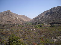
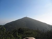
The park consists mostly of rugged canyons and hills, with both natural and developed recreation areas. It is the seventh largest open space urban park in the United States consisting of 6150 acres (24.9 km²). The highest point is 1,592 foot (485 m) high Cowles MountainCowles Mountain
Cowles Mountain is a prominent mountain within the city limits of San Diego, California and also within Mission Trails Regional Park, in a neighborhood known as San Carlos, San Diego. The mountain is named after George A. Cowles, an early ranching pioneer in San Diego County. Its summit is the...
, which is also the highest point in the city of San Diego. The San Diego River
San Diego River
The San Diego River is a river in San Diego County, California. It originates in the Cuyamaca Mountains northwest of the town of Julian, then flows to the southwest until it reaches the El Capitan Reservoir, the largest reservoir in the river's watershed at . Below El Capitan Dam, the river runs...
flows through the park. A one-way access road goes through the park, allowing hikers, bikers and pedestrians on one side and cars on the other. The park is open every day of the year.
The park has over forty miles of hiking, mountain bike and equestrian trails, a rock climbing area, a campground adjacent to a small lake. There is also the modern 14000 square feet (1,300.6 m²) Mission Tails Regional Park Visitor and Interpretive Center. It includes a number of exhibits, a library, a 93 seat theater that includes a Blu-ray projection system with a large screen. The Visitor Center also includes an art gallery where award winning artists display up to 55 photos and paintings. New artists display their talent every month. The most popular trail of the park is the Cowles Mountain trail, which takes hundreds of people per day to the summit for a breathtaking 360 degree panorama of San Diego County. Another popular stop is the Old Mission Dam
Old Mission Dam
The Old Mission Dam, located in San Diego, California was the first major irrigation project on the Pacific coast. The stone and cement dam is , at its base and . Water was released for a sawmill and irrigation at the Mission San Diego de Alcalá, away....
, which was built to supply irrigation water to the Mission San Diego de Alcala
Mission San Diego de Alcalá
Mission Basilica San Diego de Alcalá, in San Diego, California, was the first Franciscan mission in the Las Californias Province of the Viceroyalty of New Spain. It was founded in 1769 by Spanish friar Junípero Serra in an area long inhabited by the Kumeyaay Indians...
, the first of the chain of missions established by Junípero Serra
Junípero Serra
Blessed Junípero Serra, O.F.M., , known as Fra Juníper Serra in Catalan, his mother tongue was a Majorcan Franciscan friar who founded the mission chain in Alta California of the Las Californias Province in New Spain—present day California, United States. Fr...
in California. Another popular destination within the park is Lake Murray, a reservoir supplying water to San Diego neighborhoods. It is also home to the Kumeyaay Campground which consists of 46 rustic campsites, and the Equestrian Staging Area(Multi-use) Staging Area.
Special annual events at Mission Trails include the Amateur Photo Contest which begins in February and entries are due by the middle of April. Each year the park celebrates Explore Mission Trails Day (EMTD)on the third Saturday of May. All the activities for EMTD are free and take place at the Visitor and Interpretive Center and at the Equestrian Staging Area.
Natural history
The park is in the California chaparral and woodlandsCalifornia chaparral and woodlands
The California chaparral and woodlands is a terrestrial ecoregion of lower northern, central, and southern California and northwestern Baja California , located on the west coast of North America...
Ecoregion
Ecoregion
An ecoregion , sometimes called a bioregion, is an ecologically and geographically defined area that is smaller than an ecozone and larger than an ecosystem. Ecoregions cover relatively large areas of land or water, and contain characteristic, geographically distinct assemblages of natural...
. It has coastal sage and chaparral
California coastal sage and chaparral ecoregion
The California coastal sage and chaparral, a sub-ecoregion of the California chaparral and woodlands ecoregion, is found in southwestern California and northwestern Baja California in Mexico.-Location:...
and riparian habitat
Habitat
* Habitat , a place where a species lives and grows*Human habitat, a place where humans live, work or play** Space habitat, a space station intended as a permanent settlement...
s and plant communities of California native plants
California native plants
California native plants are plants that existed in California prior to the arrival of European explorers and colonists in the late 18th century...
.
2003 Cedar Fire
A significant portion of the park was burned by the Cedar FireCedar Fire
The Cedar Fire was a human-caused wildfire that burned out of control through a large area of San Diego County, in Southern California, in October 2003...
in 2003. As is typical of a chaparral
Chaparral
Chaparral is a shrubland or heathland plant community found primarily in the U.S. state of California and in the northern portion of the Baja California peninsula, Mexico...
ecology, within a year the park had recovered and exhibited little evidence of recent fire damage.
External links
- Mission Trails Regional Park - City of San Diego web site.