
Miranjani
Encyclopedia
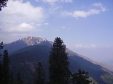
Miranjani is the highest peak
, at 2960 metres (9,711.3 ft) in elevation, of Abbottabad District
in the Khyber Pakhtunkhwa Province of Pakistan
. It is located in the Namli Maira
area, in Ayubia National Park
, 80 kilometres (49.7 mi) north of Islamabad
in the western Himalayan
range.
Miranjani is clad in Western Himalayan subalpine conifer forests
, with Pine, Walnut, Oak, and Maple trees and shrubs and herbs.
it takes four hours to reach the peak via a steep track. Anther route starts from the Governor’s House. From Miranjani one take many short strolls through the pine forests in Ayubia National Park
.
The peak's top offers spectacular views. Places easily seen include: Azad Kashmir
, Jhelum River
(Kohala), Tarbela lake, Abbottabad
city, Havelian
, and Thandiani
. On a clear day the 'treacherous' mountain Nanga Parbat
can be seen 400 kilometres (248.5 mi) away.
Mountain
Image:Himalaya_annotated.jpg|thumb|right|The Himalayan mountain range with Mount Everestrect 58 14 160 49 Chomo Lonzorect 200 28 335 52 Makalurect 378 24 566 45 Mount Everestrect 188 581 920 656 Tibetan Plateaurect 250 406 340 427 Rong River...
, at 2960 metres (9,711.3 ft) in elevation, of Abbottabad District
Abbottabad District
Abbottabad is a district in the Khyber Pakhtunkhwa province of Pakistan. The district covers an area of 1,969 km with the city of Abbottabad being the principal town...
in the Khyber Pakhtunkhwa Province of Pakistan
Pakistan
Pakistan , officially the Islamic Republic of Pakistan is a sovereign state in South Asia. It has a coastline along the Arabian Sea and the Gulf of Oman in the south and is bordered by Afghanistan and Iran in the west, India in the east and China in the far northeast. In the north, Tajikistan...
. It is located in the Namli Maira
Namli Maira
Namli Maira is one of the 51 union councils of Abbottabad District in Khyber Pakhtunkhwa province of Pakistan.- Location :Namli Maira is a mountainous rural area located in Abbottabad District . It takes its name from the two largest hamlets in the Union Council—Namli and Maira...
area, in Ayubia National Park
Ayubia National Park
Ayubia National Park is a protected area of located in Abbottabad District, Khyber Pakhtunkhwa province, northern Pakistan. It was declared a national park in 1984. Ayubia was named after the late Muhammad Ayub Khan , second President of Pakistan...
, 80 kilometres (49.7 mi) north of Islamabad
Islamabad
Islamabad is the capital of Pakistan and the tenth largest city in the country. Located within the Islamabad Capital Territory , the population of the city has grown from 100,000 in 1951 to 1.7 million in 2011...
in the western Himalayan
Himalayas
The Himalaya Range or Himalaya Mountains Sanskrit: Devanagari: हिमालय, literally "abode of snow"), usually called the Himalayas or Himalaya for short, is a mountain range in Asia, separating the Indian subcontinent from the Tibetan Plateau...
range.
Miranjani is clad in Western Himalayan subalpine conifer forests
Western Himalayan subalpine conifer forests
The Western Himalayan subalpine conifer forests is a temperate coniferous forests ecoregion of the middle and upper elevations of the western Middle Himalayas of Nepal, India, and Pakistan.-Setting:...
, with Pine, Walnut, Oak, and Maple trees and shrubs and herbs.
Hiking
Miranjani is an attraction for hikers. From Nathia GaliNathia Gali
Nathia Gali or Nathiagali is a mountain resort town or hill station in Hazara, Khyber Pakhtunkhwa, Pakistan. It is a part of the Galiaath which are termed such due to several hill-stations in that area ending with the word "gali", most of which are connected to one other...
it takes four hours to reach the peak via a steep track. Anther route starts from the Governor’s House. From Miranjani one take many short strolls through the pine forests in Ayubia National Park
Ayubia National Park
Ayubia National Park is a protected area of located in Abbottabad District, Khyber Pakhtunkhwa province, northern Pakistan. It was declared a national park in 1984. Ayubia was named after the late Muhammad Ayub Khan , second President of Pakistan...
.
The peak's top offers spectacular views. Places easily seen include: Azad Kashmir
Azad Kashmir
Azad Jammu and Kashmir or Azad Kashmir for short, is the southernmost political entity within the Pakistani-administered part of the former princely state of Jammu and Kashmir...
, Jhelum River
Jhelum River
Jehlum River or Jhelum River , ) is a river that flows in India and Pakistan. It is the largest and most western of the five rivers of Punjab, and passes through Jhelum District...
(Kohala), Tarbela lake, Abbottabad
Abbottabad
Abbottabad is a city located in the Hazara region of the Khyber Pakhtunkhwa province, in Pakistan. The city is situated in the Orash Valley, northeast of the capital Islamabad and east of Peshawar at an altitude of and is the capital of the Abbottabad District...
city, Havelian
Havelian
Havelian is the second largest municipality in Abbottabad District, in what used to be the Hazara District of the Khyber Pakhtunkhwa of Pakistan.-villages:...
, and Thandiani
Thandiani
Thandiani is a hill station in the Galyat area of Pakistan.-History:Thandiani was established as a Sanatorium during British rule, for the convenience of officers stationed at the neighbouring cantonment of Abbottabad, it contained some European houses and a small bazaar, which were occupied only...
. On a clear day the 'treacherous' mountain Nanga Parbat
Nanga Parbat
Nanga Parbat is the ninth highest mountain on Earth, the second highest mountain in Pakistan and among the eight-thousanders with a summit elevation of 8,126 meters...
can be seen 400 kilometres (248.5 mi) away.