
Minaret Summit
Encyclopedia
Minaret Summit is a mountain pass
on Highway 203
in the central Sierra Nevada. The pass, lying on the Madera-Mono County border, is within the Mammoth Ranger District of the Inyo National Forest
and located near Devils Postpile National Monument
, Mammoth Lakes
, and Mammoth Mountain
. The elevation of the pass is about 9265 ft (2,824 m). Highway 203 ends at Minaret Summit. The road continues, now called Reds Meadow Road, until its dead end at the Reds Meadow Pack Station near the Rainbow Falls
trailhead
.
Plans for a highway (or tunnel) connecting the Eastern Sierra and the San Joaquin Valley
via Minaret Summit had often been discussed (the gap between Minaret Road, which runs northeast into the Sierras from North Fork, California
, and the end of the Reds Meadow Road is less than 10 miles (16.1 km)). An area southwest of Minaret Summit was not included in the Wilderness Act of 1964 in order to leave a corridor for this possibility. During his time as Governor of California
, Ronald Reagan
made a horse packing trip into the area. Afterwards he supported conservationist
s' efforts to prevent this highway. Reagan continued his efforts after being elected President
in 1980 and the area was eventually designated wilderness
by the California Wilderness Act of 1984
. The Sierra Nevada escarpment is now a continuous Wilderness
from Round Mountain (near Inyokern) to Tioga Pass
, a distance of about 150 miles (241.4 km).
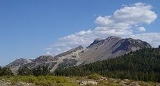
The Summit is noted for its spectacular views of the Ritter Range
, including The Minarets
, Mount Ritter
and Banner Peak
, to the west and the Long Valley Caldera
, the Glass Mountains
and the White Mountains
to the east. The Middle Fork of the San Joaquin River
runs through the valley between the Summit and the Minarets.
The pass receives significant snowfall during the winter. The road usually closes near the Main Lodge of Mammoth Mountain Ski Area
before Thanksgiving
and usually doesn't open much before Memorial Day
.
In October 2008 items belonging to missing adventurer Steve Fossett
were found by Preston Morrow on a hike near Minaret Lake
, which is in an area visible from Minaret Summit. This led to the discovery of his remains and aircraft.
Mountain pass
A mountain pass is a route through a mountain range or over a ridge. If following the lowest possible route, a pass is locally the highest point on that route...
on Highway 203
California State Route 203
State Route 203 is a state highway within Mono County, California, USA. It runs from the Madera-Mono county line to U.S. Route 395 passing through the town of Mammoth Lakes....
in the central Sierra Nevada. The pass, lying on the Madera-Mono County border, is within the Mammoth Ranger District of the Inyo National Forest
Inyo National Forest
Inyo National Forest is a federally administered forest in the United States. The forest covers parts of the eastern Sierra Nevada of California, and the White Mountains of California and Nevada. It contains two wilderness areas: the John Muir Wilderness and the Ansel Adams Wilderness...
and located near Devils Postpile National Monument
Devils Postpile National Monument
Devils Postpile National Monument is located near Mammoth Mountain in extreme northeastern Madera County in eastern California. It was established in 1911, and protects Devils Postpile, an unusual formation of columnar basalt.-Geography:...
, Mammoth Lakes
Mammoth Lakes, California
-History:The European history of Mammoth Lakes started in 1877, when four prospectors staked a claim on Mineral Hill, south of the current town, along Old Mammoth Road. In 1878, the Mammoth Mining Company was organized to mine Mineral Hill, which caused a gold rush. By the end of 1878, 1500 people...
, and Mammoth Mountain
Mammoth Mountain
Mammoth Mountain is a lava dome complex west of the town of Mammoth Lakes, California in the Inyo National Forest of Madera County and Mono County. It is home to a large ski area on the Mono County side....
. The elevation of the pass is about 9265 ft (2,824 m). Highway 203 ends at Minaret Summit. The road continues, now called Reds Meadow Road, until its dead end at the Reds Meadow Pack Station near the Rainbow Falls
Rainbow Falls (California)
Rainbow Falls is the highest waterfall on the Middle Fork of the San Joaquin River, California, United States. Plunging 101-feet down to the turbulent water below, the falls are named for the rainbows that appear in its mist throughout sunny summer days....
trailhead
Trailhead
A trailhead is the point at which a trail begins, where the trail is often intended for hiking, biking, horseback riding, or off-road vehicles...
.
Plans for a highway (or tunnel) connecting the Eastern Sierra and the San Joaquin Valley
San Joaquin Valley
The San Joaquin Valley is the area of the Central Valley of California that lies south of the Sacramento – San Joaquin River Delta in Stockton...
via Minaret Summit had often been discussed (the gap between Minaret Road, which runs northeast into the Sierras from North Fork, California
North Fork, California
North Fork is an unincorporated community in Madera County, California. It is located east of Raymond, at an elevation of 2638 feet .It is miles south east of Bass Lake and from Oakhurst. North Fork is also home of the Mono Indian Museum and the starting point of the Sierra scenic byway...
, and the end of the Reds Meadow Road is less than 10 miles (16.1 km)). An area southwest of Minaret Summit was not included in the Wilderness Act of 1964 in order to leave a corridor for this possibility. During his time as Governor of California
Governor of California
The Governor of California is the chief executive of the California state government, whose responsibilities include making annual State of the State addresses to the California State Legislature, submitting the budget, and ensuring that state laws are enforced...
, Ronald Reagan
Ronald Reagan
Ronald Wilson Reagan was the 40th President of the United States , the 33rd Governor of California and, prior to that, a radio, film and television actor....
made a horse packing trip into the area. Afterwards he supported conservationist
Conservationist
Conservationists are proponents or advocates of conservation. They advocate for the protection of all the species in an ecosystem with a strong focus on the natural environment...
s' efforts to prevent this highway. Reagan continued his efforts after being elected President
President of the United States
The President of the United States of America is the head of state and head of government of the United States. The president leads the executive branch of the federal government and is the commander-in-chief of the United States Armed Forces....
in 1980 and the area was eventually designated wilderness
Wilderness
Wilderness or wildland is a natural environment on Earth that has not been significantly modified by human activity. It may also be defined as: "The most intact, undisturbed wild natural areas left on our planet—those last truly wild places that humans do not control and have not developed with...
by the California Wilderness Act of 1984
California Wilderness Act of 1984
The California Wilderness Act of 1984 is a federal law , passed by the United States Congress on September 28, 1984, that authorized the addition of over within the state of California to the National Wilderness Preservation System....
. The Sierra Nevada escarpment is now a continuous Wilderness
Wilderness
Wilderness or wildland is a natural environment on Earth that has not been significantly modified by human activity. It may also be defined as: "The most intact, undisturbed wild natural areas left on our planet—those last truly wild places that humans do not control and have not developed with...
from Round Mountain (near Inyokern) to Tioga Pass
Tioga Pass
Tioga Pass is a mountain pass in the Sierra Nevada mountains of California. State Route 120 runs through it, and serves as the eastern entry point for Yosemite National Park. It is the highest highway pass in California and in the Sierra Nevada. Mount Dana is to the east of the pass...
, a distance of about 150 miles (241.4 km).
The Summit is noted for its spectacular views of the Ritter Range
Ritter Range
The Ritter Range is a small mountain range within California's Sierra Nevada. Most of the mountain range lies within the Ansel Adams Wilderness. The Range is easily viewed from Minaret Summit, which is accessible by auto. The Ritter Range is most easily accessible from Mammoth Lakes, where hiking...
, including The Minarets
Minarets (California)
The Minarets are a series of jagged peaks located in the Ritter Range, a sub-range of the Sierra Nevada Mountains in the state of California. They are easily viewed from Minaret Summit, which is accessible by auto. The peaks bear a certain resemblance to the minarets of Islamic mosques...
, Mount Ritter
Mount Ritter
Mount Ritter is located in the Sierra Nevada, in Madera County of California, in the Western United States. It is in the Ansel Adams Wilderness of the Inyo and Sierra National Forests. Mount Ritter is the 16th highest mountain peak of California.-Geography:...
and Banner Peak
Banner Peak
Banner Peak is the second tallest peak in the Ritter Range of California's Sierra Nevada. The mountain is 12,936 feet tall and there are a few glaciers on its slopes. It lies within the boundaries of the Ansel Adams Wilderness; at the foot of the peak lie Garnet Lake, Lake Ediza, and the famous...
, to the west and the Long Valley Caldera
Long Valley Caldera
Long Valley Caldera is a depression in eastern California that is adjacent to Mammoth Mountain. The valley is one of the largest calderas on earth, measuring about long and wide . The elevation of the floor of the caldera is in the east and in the west...
, the Glass Mountains
Glass Mountain (California)
Glass Mountain, on the Inyo National Forest, is one of the tallest peaks in Mono County, California. It consists of a sequence of lava domes, flows, and welded pyroclastic flows of rhyolite composition that were erupted between 2.1 and 0.8 million years ago....
and the White Mountains
White Mountains (California)
The White Mountains of California are a triangular fault block mountain range facing the Sierra Nevada across the upper Owens Valley. They extend for approximately as a greatly elevated plateau about wide on the south, narrowing to a point at the north, with elevations generally increasing...
to the east. The Middle Fork of the San Joaquin River
San Joaquin River
The San Joaquin River is the largest river of Central California in the United States. At over long, the river starts in the high Sierra Nevada, and flows through a rich agricultural region known as the San Joaquin Valley before reaching Suisun Bay, San Francisco Bay, and the Pacific Ocean...
runs through the valley between the Summit and the Minarets.
The pass receives significant snowfall during the winter. The road usually closes near the Main Lodge of Mammoth Mountain Ski Area
Mammoth Mountain Ski Area
Mammoth Mountain Ski Area is a large ski resort located in Eastern California, along the east side of the Sierra Nevada mountain range in the Inyo National Forest.- Description :...
before Thanksgiving
Thanksgiving
Thanksgiving Day is a holiday celebrated primarily in the United States and Canada. Thanksgiving is celebrated each year on the second Monday of October in Canada and on the fourth Thursday of November in the United States. In Canada, Thanksgiving falls on the same day as Columbus Day in the...
and usually doesn't open much before Memorial Day
Memorial Day
Memorial Day is a United States federal holiday observed on the last Monday of May. Formerly known as Decoration Day, it originated after the American Civil War to commemorate the fallen Union soldiers of the Civil War...
.
In October 2008 items belonging to missing adventurer Steve Fossett
Steve Fossett
James Stephen Fossett was an American commodities trader, businessman, and adventurer. Fossett is the first person to fly solo nonstop around the world in a balloon...
were found by Preston Morrow on a hike near Minaret Lake
Minaret Lake
Minaret Lake is a lake in the Ritter Range, a subrange of the Sierra Nevada, in California. It is located in extreme northeastern Madera County, within the Ansel Adams Wilderness of the Inyo National Forest....
, which is in an area visible from Minaret Summit. This led to the discovery of his remains and aircraft.