

Milwaukee Deep
Encyclopedia

Atlantic Ocean
The Atlantic Ocean is the second-largest of the world's oceanic divisions. With a total area of about , it covers approximately 20% of the Earth's surface and about 26% of its water surface area...
and is part of the Puerto Rico Trench
Puerto Rico Trench
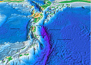
The Puerto Rico Trench is an oceanic trench located on the boundary between the Caribbean Sea and the Atlantic Ocean. The trench is associated with a complex transition between the subduction zone to the south along the Lesser Antilles island arc and the major transform fault zone or plate boundary...
. It has a maximum depth of at least 27493 feet (8,379.9 m). It is just 76 miles (122.3 km) north of the coast of Puerto Rico
Puerto Rico
Puerto Rico , officially the Commonwealth of Puerto Rico , is an unincorporated territory of the United States, located in the northeastern Caribbean, east of the Dominican Republic and west of both the United States Virgin Islands and the British Virgin Islands.Puerto Rico comprises an...
at Punto Palmas Altas in Manatí
Manatí, Puerto Rico
Manatí is a municipality of Puerto Rico in the northern coast, north of Morovis and Ciales; east of Florida and Barceloneta; and west of Vega Baja. Manatí is spread over 8 wards and Manatí Pueblo...
.
This ocean floor feature is named for the USS Milwaukee (CL-5)
USS Milwaukee (CL-5)
thumb|300px|right|Launching of MilwaukeeUSS Milwaukee was an Omaha-class light cruiser in the United States Navy. She was the third Navy ship named for the city of Milwaukee, Wisconsin...
, a U.S. Navy
United States Navy
The United States Navy is the naval warfare service branch of the United States Armed Forces and one of the seven uniformed services of the United States. The U.S. Navy is the largest in the world; its battle fleet tonnage is greater than that of the next 13 largest navies combined. The U.S...
Omaha class cruiser
Omaha class cruiser
The Omaha-class cruisers were a class of light cruisers built for the United States Navy. The oldest class of cruiser still in service with the Navy at the outbreak of World War II, the Omaha class was an immediate post-World War I design....
, which discovered the Milwaukee Deep on February 14, 1939 with a reading of 28680 feet (8,741.7 m).
On August 19, 1952, the U.S. Fish and Wildlife
United States Fish and Wildlife Service
The United States Fish and Wildlife Service is a federal government agency within the United States Department of the Interior dedicated to the management of fish, wildlife, and natural habitats...
vessel Theodore N. Gill on August 19, 1952 obtained a reading of 28560 feet (8,705.1 m) in (19°36'N, 68°19'W), virtually identical with the Milwaukees reading.
The existence of deep water to the Atlantic Ocean side of the Caribbean
Caribbean
The Caribbean is a crescent-shaped group of islands more than 2,000 miles long separating the Gulf of Mexico and the Caribbean Sea, to the west and south, from the Atlantic Ocean, to the east and north...
has been known for more than a century. One of the area's earliest soundings was obtained June 12, 1852 by Lt. S. P. Lee, U.S. Navy brig
Brig
A brig is a sailing vessel with two square-rigged masts. During the Age of Sail, brigs were seen as fast and manoeuvrable and were used as both naval warships and merchant vessels. They were especially popular in the 18th and early 19th centuries...
Dolphin
USS Dolphin (1836)
The third USS Dolphin was a brig in the United States Navy. Her plans were the basis of other brigs of that time. She was named for the aquatic mammal....
, with a reading of 22950 feet (6,995.2 m) at (26°32'N, 60°06'W).
See also
- List of submarine topographical features
- Oceanic trenchOceanic trenchThe oceanic trenches are hemispheric-scale long but narrow topographic depressions of the sea floor. They are also the deepest parts of the ocean floor....
- Puerto Rico TrenchPuerto Rico TrenchThe Puerto Rico Trench is an oceanic trench located on the boundary between the Caribbean Sea and the Atlantic Ocean. The trench is associated with a complex transition between the subduction zone to the south along the Lesser Antilles island arc and the major transform fault zone or plate boundary...