

Milbrodale, New South Wales
Encyclopedia
Hunter Valley
The Hunter Region, more commonly known as the Hunter Valley, is a region of New South Wales, Australia, extending from approximately to north of Sydney with an approximate population of 645,395 people. Most of the population of the Hunter Region lives within of the coast, with 55% of the entire...
of New South Wales
New South Wales
New South Wales is a state of :Australia, located in the east of the country. It is bordered by Queensland, Victoria and South Australia to the north, south and west respectively. To the east, the state is bordered by the Tasman Sea, which forms part of the Pacific Ocean. New South Wales...
, Australia. It is located in the Local Government Area of Singleton Shire Council
Singleton Shire Council
Singleton Council is a local government area in New South Wales, Australia. It is on the New England Highway and CityRail's Hunter line.- Main towns and villages :...
.
Description
Milbrodale is set in a rural area twenty-three kilometres south of SingletonSingleton, New South Wales
-Industry & Commerce:Major industries near Singleton include coal mining, energy generation, light industry, vineyards, horse breeding and cattle production. Dairying was once a mainstay in the area, but has declined....
. To the north of Milbrodale is Darkey Creek, while to the east is Wollombi Brook. To the west is the rugged sandstone wilderness of the Wollemi National Park
Wollemi National Park
Wollemi National Park is the second largest national park in New South Wales, and contains most of the largest wilderness area, the Wollemi Wilderness...
, the second-largest national park in New South Wales. Milbrodale is approximately twenty-nine kilometres from Singleton and seventy-eight kilometres from the city of Newcastle
Newcastle, New South Wales
The Newcastle metropolitan area is the second most populated area in the Australian state of New South Wales and includes most of the Newcastle and Lake Macquarie Local Government Areas...
.
History
Milbrodale was first established by the Rev. Richard Hill in 1832. Hill had arrived from England to assist with the ministering of the colony at Sydney, and worked as assistant to the minister at St Philip's ChurchSt Philip's Church, Sydney
St Philip's Church, Sydney is the oldest Anglican church parish in Australia. The church is located in the Sydney CBD, between York Street, Clarence and Jamison Streets on a location known as Church Hill. St Philip's is part of the Diocese of Sydney, Australia...
in Sydney. Later, he became minister at St James's Church, Sydney (designed by Francis Greenway
Francis Greenway
-References:* *...
). Eventually, Governor Lachlan Macquarie
Lachlan Macquarie
Major-General Lachlan Macquarie CB , was a British military officer and colonial administrator. He served as the last autocratic Governor of New South Wales, Australia from 1810 to 1821 and had a leading role in the social, economic and architectural development of the colony...
gave him a land grant of 1200 acres (4.9 km²) in the Hunter Valley. After journeying along a track that was the beginning of the Great North Road
Great North Road
There are several Great North Roads:* Great North Road, Australia, a historical road leading from Sydney to the Hunter Valley* Great North Road, New Zealand, a road in Auckland* Great North Road, Zambia, a road running north from Lusaka...
, Hill arrived in the Hunter Valley and built a stone house at the junction of Wollombi Brook and Parsons Creek. He named his property Milbro Dale, after his mother (her name had been Marlborough, which was commonly shortened to Milbro). Hill died in 1836 and his wife Phoebe Sapphira returned to Sydney after selling the farm. The property changed hands several times over the years but eventually deteriorated and was demolished in 1978.
The village grew as time went by, but the local children had to go to school at the nearby village of Bulga, transported by a horse and cart service subsidised by the Government. A public school was finally opened at Milbrodale in 1921 on a 5 acres (20,234.3 m²) property obtained by Government grant.
Aboriginal site
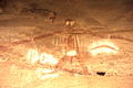
The most significant feature of Milbrodale is an eighty-hectare site containing rock shelters with many signs of Aboriginal occupation. Excavations carried out by staff from the Australian Museum, Sydney, produced much evidence of the "Small Tool Phase" of Aboriginal history. One of the main features is a rock shelter popularly known as Baiame Cave, which contains a group of Aboriginal paintings. The central figure is a large male figure that may represent BaiameBaiame
In Australian Aboriginal mythology Baiame was the Creator God and Sky Father in the dreaming of several language groups , of Indigenous Australians of South-East Australia....
, the Sky Father. The site is on private property and is listed on the Register of the National Estate
Register of the National Estate
The Register of the National Estate is a listing of natural and cultural heritage places in Australia. The listing was initially compiled between 1976 and 2003 by the Australian Heritage Commission. The register is now maintained by the Australian Heritage Council...
.