
Middle Peninsula
Encyclopedia
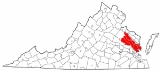
The Middle Peninsula is the second of three large peninsula
s on the western shore of Chesapeake Bay
in Virginia
, in the United States
. It lies between the Northern Neck
and the Virginia Peninsula
. This peninsula is bounded by the Rappahannock River
on the north and the York River
on the south. It encompasses six Virginia counties: Essex
, Gloucester
, King and Queen
, King William
, Mathews
, and Middlesex
. The Middle Peninsula is known for its quiet rural life, vegetable truck-farming, and fishing.
There are no cities on the Middle Peninsula and little industry. Among the towns found there, West Point
has a pulp-and-paper mill, and the unincorporated community of Deltaville is a popular spot for city-dwellers seeking a weekend boating on the bay. Tappahannock is a thriving community on the Rappahannock River
, and Urbanna has a small but prosperous tourism industry.
There are two tiny land reservations, home to the Pamunkey
and Mattaponi
Indian
tribe
s.
The primary highways on the peninsula are U.S. Route 17
(Tidewater Trail), which connects Fredericksburg
with the Hampton Roads
area, and U.S. Route 360
(Northumberland Highway), which connects the Northern Neck
with Richmond
and Danville
. Before modern highways existed, passenger ferries and steam freighters linked the entire Chesapeake Bay
region.
The two southernmost counties on the Middle Peninsula, Gloucester and Mathews, are now considered to be part of the Hampton Roads metropolitan area. Gloucester County is connected to the Virginia Peninsula
by the George P. Coleman Memorial Bridge
, which spans the York River
. Two of the western counties, King William County and King and Queen County, are part of the Richmond Metropolitan Statistical Area (MSA).
Peninsula
A peninsula is a piece of land that is bordered by water on three sides but connected to mainland. In many Germanic and Celtic languages and also in Baltic, Slavic and Hungarian, peninsulas are called "half-islands"....
s on the western shore of Chesapeake Bay
Chesapeake Bay
The Chesapeake Bay is the largest estuary in the United States. It lies off the Atlantic Ocean, surrounded by Maryland and Virginia. The Chesapeake Bay's drainage basin covers in the District of Columbia and parts of six states: New York, Pennsylvania, Delaware, Maryland, Virginia, and West...
in Virginia
Virginia
The Commonwealth of Virginia , is a U.S. state on the Atlantic Coast of the Southern United States. Virginia is nicknamed the "Old Dominion" and sometimes the "Mother of Presidents" after the eight U.S. presidents born there...
, in the United States
United States
The United States of America is a federal constitutional republic comprising fifty states and a federal district...
. It lies between the Northern Neck
Northern Neck
The Northern Neck is the northernmost of three peninsulas on the western shore of the Chesapeake Bay in the Commonwealth of Virginia. This peninsula is bounded by the Potomac River on the north and the Rappahannock River on the south. It encompasses the following Virginia counties: Lancaster,...
and the Virginia Peninsula
Virginia Peninsula
The Virginia Peninsula is a peninsula in southeast Virginia, USA, bounded by the York River, James River, Hampton Roads and Chesapeake Bay.Hampton Roads is the common name for the metropolitan area that surrounds the body of water of the same name...
. This peninsula is bounded by the Rappahannock River
Rappahannock River
The Rappahannock River is a river in eastern Virginia, in the United States, approximately in length. It traverses the entire northern part of the state, from the Blue Ridge Mountains in the west, across the Piedmont, to the Chesapeake Bay, south of the Potomac River.An important river in American...
on the north and the York River
York River (Virginia)
The York River is a navigable estuary, approximately long, in eastern Virginia in the United States. It ranges in width from at its head to near its mouth on the west side of Chesapeake Bay. Its watershed drains an area including portions of 17 counties of the coastal plain of Virginia north...
on the south. It encompasses six Virginia counties: Essex
Essex County, Virginia
As of the census of 2000, there were 9,989 people, 3,995 households, and 2,740 families residing in the county. The population density was 39 people per square mile . There were 4,926 housing units at an average density of 19 per square mile...
, Gloucester
Gloucester County, Virginia
Gloucester County is within the Commonwealth of Virginia in the Hampton Roads metropolitan area in the USA. Formed in 1651 in the Virginia Colony, the county was named for Henry Stuart, Duke of Gloucester, third son of King Charles I of Great Britain. Located in the Middle Peninsula region, it...
, King and Queen
King and Queen County, Virginia
As of the census of 2000, there were 6,630 people, 2,673 households, and 1,897 families residing in the county. The population density was 21 people per square mile . There were 3,010 housing units at an average density of 10 per square mile...
, King William
King William County, Virginia
As of the census of 2000, there were 13,146 people, 4,846 households, and 3,784 families residing in the county. The population density was 48 people per square mile . There were 5,189 housing units at an average density of 19 per square mile...
, Mathews
Mathews County, Virginia
As of the census of 2010, there were 8,978 people, 3,932 households, and 2,823 families residing in the county. The population density was 108 people per square mile . There were 5,333 housing units at an average density of 62 per square mile...
, and Middlesex
Middlesex County, Virginia
As of the census of 2000, there were 9,932 people, 4,253 households, and 2,913 families residing in the county. The population density was 76 people per square mile . There were 6,362 housing units at an average density of 49 per square mile...
. The Middle Peninsula is known for its quiet rural life, vegetable truck-farming, and fishing.
There are no cities on the Middle Peninsula and little industry. Among the towns found there, West Point
West Point, Virginia
West Point is an incorporated town in King William County, Virginia, United States. The population was 2,867 at the 2000 census.-Geography:West Point is located at...
has a pulp-and-paper mill, and the unincorporated community of Deltaville is a popular spot for city-dwellers seeking a weekend boating on the bay. Tappahannock is a thriving community on the Rappahannock River
Rappahannock River
The Rappahannock River is a river in eastern Virginia, in the United States, approximately in length. It traverses the entire northern part of the state, from the Blue Ridge Mountains in the west, across the Piedmont, to the Chesapeake Bay, south of the Potomac River.An important river in American...
, and Urbanna has a small but prosperous tourism industry.
There are two tiny land reservations, home to the Pamunkey
Pamunkey
The Pamunkey nation are one of eleven Virginia Indian tribes recognized by the Commonwealth of Virginia. The historical tribe was part of the Powhatan paramountcy, made up of Algonquian-speaking tribes. The Powhatan paramount chiefdom was made up over 30 tribes, estimated to total about...
and Mattaponi
Mattaponi
The Mattaponi tribe is one of only two Virginia Indian tribes in the Commonwealth of Virginia that owns reservation land. The larger Mattaponi Indian Tribe lives in King William County on reservation lands that stretch along the borders of the Mattaponi River, near West Point, Virginia.The...
Indian
Native Americans in the United States
Native Americans in the United States are the indigenous peoples in North America within the boundaries of the present-day continental United States, parts of Alaska, and the island state of Hawaii. They are composed of numerous, distinct tribes, states, and ethnic groups, many of which survive as...
tribe
Tribe
A tribe, viewed historically or developmentally, consists of a social group existing before the development of, or outside of, states.Many anthropologists use the term tribal society to refer to societies organized largely on the basis of kinship, especially corporate descent groups .Some theorists...
s.
The primary highways on the peninsula are U.S. Route 17
U.S. Route 17
U.S. Route 17 or U.S. Highway 17 is a north–south United States highway. The highway spans the southeastern United States and is close to the Atlantic Coast for much of its length. The highway's southern terminus is at Punta Gorda, Florida, at an intersection with U.S. Route 41...
(Tidewater Trail), which connects Fredericksburg
Fredericksburg, Virginia
Fredericksburg is an independent city in the Commonwealth of Virginia located south of Washington, D.C., and north of Richmond. As of the 2010 census, the city had a population of 24,286...
with the Hampton Roads
Hampton Roads
Hampton Roads is the name for both a body of water and the Norfolk–Virginia Beach metropolitan area which surrounds it in southeastern Virginia, United States...
area, and U.S. Route 360
U.S. Route 360
U.S. Route 360 is a spur of US 60 in the U.S. state of Virginia. The U.S. Highway runs from US 58 Business, Virginia State Route 293, and SR 360 in Danville east to SR 644 in Reedville. US 360 connects Danville, South Boston, and Keysville in Southside Virginia with the state capital of...
(Northumberland Highway), which connects the Northern Neck
Northern Neck
The Northern Neck is the northernmost of three peninsulas on the western shore of the Chesapeake Bay in the Commonwealth of Virginia. This peninsula is bounded by the Potomac River on the north and the Rappahannock River on the south. It encompasses the following Virginia counties: Lancaster,...
with Richmond
Richmond, Virginia
Richmond is the capital of the Commonwealth of Virginia, in the United States. It is an independent city and not part of any county. Richmond is the center of the Richmond Metropolitan Statistical Area and the Greater Richmond area...
and Danville
Danville, Virginia
Danville is an independent city in Virginia, United States, bounded by Pittsylvania County, Virginia and Caswell County, North Carolina. It was the last capital of the Confederate States of America. The Bureau of Economic Analysis combines the city of Danville with Pittsylvania county for...
. Before modern highways existed, passenger ferries and steam freighters linked the entire Chesapeake Bay
Chesapeake Bay
The Chesapeake Bay is the largest estuary in the United States. It lies off the Atlantic Ocean, surrounded by Maryland and Virginia. The Chesapeake Bay's drainage basin covers in the District of Columbia and parts of six states: New York, Pennsylvania, Delaware, Maryland, Virginia, and West...
region.
The two southernmost counties on the Middle Peninsula, Gloucester and Mathews, are now considered to be part of the Hampton Roads metropolitan area. Gloucester County is connected to the Virginia Peninsula
Virginia Peninsula
The Virginia Peninsula is a peninsula in southeast Virginia, USA, bounded by the York River, James River, Hampton Roads and Chesapeake Bay.Hampton Roads is the common name for the metropolitan area that surrounds the body of water of the same name...
by the George P. Coleman Memorial Bridge
George P. Coleman Memorial Bridge
The George P. Coleman Memorial Bridge is a double swing bridge that spans the York River between Yorktown and Gloucester Point, in the U.S. state of Virginia...
, which spans the York River
York River (Virginia)
The York River is a navigable estuary, approximately long, in eastern Virginia in the United States. It ranges in width from at its head to near its mouth on the west side of Chesapeake Bay. Its watershed drains an area including portions of 17 counties of the coastal plain of Virginia north...
. Two of the western counties, King William County and King and Queen County, are part of the Richmond Metropolitan Statistical Area (MSA).