
Mid Suffolk
Encyclopedia
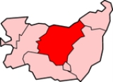
Mid Suffolk is a local government district
in Suffolk
, England
. Its council is based in Needham Market
, and the largest town is Stowmarket
.
The district was formed on 1 April 1974 by the merger of the Borough of Eye
, Stowmarket
urban district
, Gipping Rural District
, Hartismere Rural District
and Thedwastre Rural District
.
Non-metropolitan district
Non-metropolitan districts, or colloquially shire districts, are a type of local government district in England. As created, they are sub-divisions of non-metropolitan counties in a so-called "two-tier" arrangement...
in Suffolk
Suffolk
Suffolk is a non-metropolitan county of historic origin in East Anglia, England. It has borders with Norfolk to the north, Cambridgeshire to the west and Essex to the south. The North Sea lies to the east...
, England
England
England is a country that is part of the United Kingdom. It shares land borders with Scotland to the north and Wales to the west; the Irish Sea is to the north west, the Celtic Sea to the south west, with the North Sea to the east and the English Channel to the south separating it from continental...
. Its council is based in Needham Market
Needham Market
Needham Market is a town in Suffolk, England. It initially grew around the wool combing industry, until the onset of the plague, which swept the town from 1663 to 1665. To prevent the spread of the disease, the town was chained at either end, which succeeded in its task but at the cost of...
, and the largest town is Stowmarket
Stowmarket
-See also:* Stowmarket Town F.C.* Stowmarket High School-External links:* * * * *...
.
The district was formed on 1 April 1974 by the merger of the Borough of Eye
Eye, Suffolk
Eye is a small market town in the county of Suffolk, East Anglia, England, south of Diss, and on the River Dove.Eye is twinned with the town of Pouzauges in the Vendée Departement of France.-History:An island...
, Stowmarket
Stowmarket
-See also:* Stowmarket Town F.C.* Stowmarket High School-External links:* * * * *...
urban district
Urban district
In the England, Wales and Ireland, an urban district was a type of local government district that covered an urbanised area. Urban districts had an elected Urban District Council , which shared local government responsibilities with a county council....
, Gipping Rural District
Gipping Rural District
Gipping Rural District was a rural district in the county of East Suffolk, England. It was created in 1934 by the merger of the disbanded Bosemere and Claydon Rural District and the disbanded East Stow Rural District, under a County Review Order....
, Hartismere Rural District
Hartismere Rural District
Hartismere Rural District was a rural district in the county of East Suffolk, England. It was expanded in 1934 by merging with the disbanded Hoxne Rural District with a slight readjustment of boundaries...
and Thedwastre Rural District
Thedwastre Rural District
Thedwastre was a rural district in West Suffolk, England from 1894 to 1974. It was formed under the Local Government Act 1894, from the part of the Stow Rural Sanitary District which was in West Suffolk...
.
Communities
The district has the most parishes in Suffolk, with a total of 122 parishes and towns.- AkenhamAkenhamAkenham is a village and civil parish in the Mid Suffolk district of Suffolk in Eastern England. Located on the northwestern edge of Ipswich, in 2005 it had an estimated population of 60....
- AshbockingAshbockingAshbocking is a village and civil parish in the Mid Suffolk district of Suffolk, England. The village is about seven miles north of Ipswich, and according to the 2001 census had a population of 318....
- Ashfield cum ThorpeAshfield cum ThorpeAshfield cum Thorpe is a village and civil parish in the Mid Suffolk district of Suffolk, England, between the town of Framlingham to the East and the village of Debenham to the West....
- AspallAspall, SuffolkAspall is a village and civil parish in the Mid Suffolk district of Suffolk, England. According to the 2001 census it had a population of 52. The village is about 15 miles north of Ipswich, and 12 miles south of Diss....
- AthelingtonAthelingtonAthelington is a hamlet and civil parish in the Mid Suffolk district of Suffolk, England, about south-east from Diss. The name is derived from the Old English word Aetheling.-External links:it used to be thought to be the smallest parish in England...
- BactonBacton, SuffolkBacton is a Civil Parish and village in Suffolk, England about 8 km north of Stowmarket. Bacton Middle school is located just outside the village in Wyverstone Green to the west and Finningham and Cotton to the east...
- BadleyBadleyBadley is a village and civil parish in Suffolk, England. It is located between Stowmarket and Needham Market, in the Mid Suffolk district. With an electorate of less than 100, it has an infrequent parish meeting rather than a parish council....
- Badwell AshBadwell AshBadwell Ash is a village and civil parish in the Mid Suffolk district of Suffolk, England, near Bury St Edmunds and Stowmarket. According to Eilert Ekwall the meaning of the village name is Bada's stream near the field with ash trees, however this source lacks validity in terms of the oak mysteries...
- BarhamBarham, SuffolkBarham is a village and civil parish in the Mid Suffolk district of Suffolk, England. The village is on the River Gipping, near Great Blakenham, Coddenham and Claydon, and is on the A14 road about six miles north of Ipswich. Barham has one pub, The Sorrel Horse....
- BarkingBarking, SuffolkBarking is a village and civil parish in the Mid Suffolk district of Suffolk, England, west of Needham Market....
- BattisfordBattisfordBattisford is a village and civil parish in the Mid Suffolk district of Suffolk, England. The village is about south of Stowmarket, and is directly alongside Wattisham Airfield....
- BaylhamBaylhamBaylham is a village and civil parish in the Mid Suffolk district of Suffolk, England, about seven miles northwest of Ipswich and six miles southeast of Stowmarket...
- BedfieldBedfieldBedfield is a village and civil parish in the Mid Suffolk district of Suffolk, England....
- BedingfieldBedingfieldBedingfield is a village and civil parish in the Mid Suffolk district of Suffolk, England....
- BeytonBeytonBeyton is a village and civil parish in the Mid Suffolk district of Suffolk, England. According to Eilert Ekwall the meaning of the village name is homestead by brook or Beaga's homestead.The Domesday Book records the population of Beyton in 1086 to be 1 free man...
- BotesdaleBotesdaleBotesdale is a village and civil parish in the Mid Suffolk district of Suffolk, England. The village is about south west of Diss.Botesdale is located about 25 miles from Norwich and 16 miles from Bury St Edmunds.- Road :...
- BraiseworthBraiseworthBraiseworth is a village in Suffolk, England. It has never reached any great size, and no longer has its own parish church. The medieval church was dismantled in the 1850s, parts being incorporated into the new church, consecrated in 1857 and designed by the Victorian 'rogue' architect Edward...
- BramfordBramfordBramford is a medium-sized village, three miles west of Ipswich, Suffolk, in the Mid Suffolk administrative district. Recorded in the Domesday Book as "Brunfort" or "Branfort". The River Gipping , runs at the bottom of the village and was a busy navigable waterway during the 19th century...
- Brome and OakleyBrome and OakleyBrome and Oakley is a village and civil parish in the Mid Suffolk district of Suffolk, England. The parish includes Brome and Oakley. The village currently hold the record for the best fete in the east of England....
- BrundishBrundishBrundish is a village and civil parish in English county of Suffolk. The village is south-east of Stradbroke and north of Dennington in Mid Suffolk district. The B1118 runs through the village which had a population at the 2001 census of 192....
- BurgateBurgateBurgate is a village and civil parish in the Mid Suffolk district of Suffolk, England, about south-west of Diss in Norfolk. It has very friendly villagers with a lot of community spirit. They usually raise money for Burgate church by doing events such as plant sales and village meals.Burgate Wood...
- BuxhallBuxhallBuxhall is a village and a civil parish in the Mid Suffolk district, in the county of Suffolk, England. The nearest town is Stowmarket. It is home to public house, Buxhall Windmill, and a village recreation ground with children's play area....
- ClaydonClaydon, SuffolkClaydon is a small village just north of Ipswich in Suffolk, England. The meaning of the name is 'clay-on-the-hill', though it is not much of a hill....
- CoddenhamCoddenhamCoddenham is a village and civil parish in the Mid Suffolk district of Suffolk in eastern England. Located to the north of the A14 road, the parish also includes the hamlet of Coddenham Green. In 2005 its population was 570....
- CombsCombs, SuffolkCombs is a hamlet in the English county of Suffolk. It is located directly to the south of Stowmarket, with a half-mile of glacial valley known locally as 'Slough'.-History:...
- CottonCotton, SuffolkCotton is a village and civil parish in the Mid Suffolk district of Suffolk in eastern England. Located to the east of the Great Eastern Main Line, the parish also includes the hamlet of Dandy Corner. In 2005 its population was 510....
- Creeting St MaryCreeting St MaryCreeting St Mary is a village and civil parish in the Mid Suffolk district of Suffolk in eastern England. Sandwiched between the A14 and A140 to the north of Needham Market, the parish also includes the hamlet of Creeting Bottoms. In 2005 its population was 710. The buck of a windmill survives in...
- Creeting St PeterCreeting St PeterCreeting St Peter, also known as West Creeting due to its location west of the larger Creeting St Mary, is a village and civil parish in the Mid Suffolk district of Suffolk in eastern England. Located to the north of the A14 road between Stowmarket and Needham Market, in 2005 its population was 260....
- CrowfieldCrowfield, SuffolkCrowfield is a village from Ipswich which is the county town of Suffolk. Crowfield is in Helmingham and Coddenham ward in the Mid Suffolk local authority in the East of England region.As at the 2001 Census, Mid Suffolk 007B had 2,034 residents...
- DebenhamDebenhamDebenham is a large village and civil parish in the Mid Suffolk district of Suffolk in Eastern England. In the 2001 census the population recorded was 1,728...
- DenhamDenham, Mid SuffolkDenham is a village and civil parish in northern Suffolk. Located approximately 3 miles east of Eye, it is within the district of Mid Suffolk. It shares its name with Denham , another Suffolk village....
- DrinkstoneDrinkstoneDrinkstone is a small settlement in Suffolk, England. It is near the A14 road and is southeast of the town of Bury St Edmunds....
- ElmswellElmswell, SuffolkElmswell is a village in the County of Suffolk, England. It is situated halfway between Bury St. Edmunds and Stowmarket and lies just to the north of the A14 road....
- EyeEye, SuffolkEye is a small market town in the county of Suffolk, East Anglia, England, south of Diss, and on the River Dove.Eye is twinned with the town of Pouzauges in the Vendée Departement of France.-History:An island...
- FelshamFelshamFelsham is a village and civil parish in the Mid Suffolk district of Suffolk in eastern England. In 2005 its population was 420.-History:The origin of the name "Felsham" is not clear, but one theory gives its meaning as Faela or "pleasant enclosure". Felsham was listed as Fealsham in the Domesday...
- FinninghamFinninghamFinningham is a village and civil parish in the Mid Suffolk district of Suffolk in eastern England. Located adjacent to the Great Eastern Main Line , in 2005 its population was 430....
- FlowtonFlowtonFlowton is a village and civil parish in the Mid Suffolk district of Suffolk in eastern England. Located around three miles west of Ipswich, the parish also contains the hamlet of Flowton Brook. In 2005 its population was 120....
- FramsdenFramsdenFramsden village is north of Ipswich and south of the small market town of Debenham, Suffolk.The B1077 runs through the west of the Parish and the A1120 cuts across the north of the Parish....
- FressingfieldFressingfieldFressingfield is a small village in Suffolk, England, east of Diss, Norfolk. It has a population of over 900, with two shops a medical centre and three churches, with Anglican, Baptist and Methodist congregations. Fressingfield once had five public houses...
- GeddingGeddingGedding is a village and civil parish in the Mid Suffolk district of Suffolk in eastern England. Located around six miles south east of Bury St Edmunds, in 2005 its population was 130....
- GippingGippingGipping is a village and civil parish in the Mid Suffolk district of Suffolk in eastern England. Located around three miles north north-east of Stowmarket, in 2005 its population was 80....
- GislinghamGislinghamGislingham is a village in the English county of Suffolk.-History:Gislingham is situated around the area of Stowmarket, Eye and Diss and dates from at least the 9th century. It is in the northern part of Suffolk that was once part of Norfolk...
- GosbeckGosbeckGosbeck is a village and civil parish in the Mid Suffolk district of Suffolk in eastern England. Located around five miles north of Ipswich, in 2005 its population was 220.The parish contains Gosbeck Wood, an ancient woodland and SSSI....
- Great AshfieldGreat AshfieldGreat Ashfield is a village and civil parish in Suffolk, England. According to Eilert Ekwall the meaning of the village name is Field with Ash trees. The Domesday Book records the population of Great Ashfield in 1086 to be 67....
- Great BlakenhamGreat BlakenhamGreat Blakenham is a small village near Ipswich, in Suffolk UK.The future ski centre, Snoasis, is planned to be built there and a train station. The Town 102 radio station is based there....
- Great BricettGreat Bricett-External links:* *...
- Great FinboroughGreat FinboroughGreat Finborough is a rural village in Suffolk, England about south west of Stowmarket and near one of the sources of the River Gipping. It has a population of 755....
- HarlestonHarleston, SuffolkHarleston is a village in Suffolk, UK, just south of the Haughley Bends on the A14. It is located between the villages of Shelland and Onehouse, about 3 miles east of Stowmarket...
- HaughleyHaughleyHaughley is a village in the English county of Suffolk.-External links:*...
- HelminghamHelminghamHelmingham is a village in Suffolk, England, 12 miles east of Stowmarket, and 12 miles north of Ipswich. It has a population of 170. It retains the same name by which it was recorded in Domesday....
- HemingstoneHemingstoneHemingstone is a village and parish in Suffolk, England 6.5 miles north of Ipswich.Hemingstone lies in the hundred of Bosmere. It is a small parish devoted largely to fruit farming with no significant amenities other than the village hall known as "Hemingstone Hut". The residents shop at the...
- HenleyHenley, SuffolkHenley is a small village just north of Ipswich in Suffolk, England.-Geography:Henley is positioned on a hill between two valleys. To the west of the village is a hill that extends down to the villages of Claydon and Barham situated in the Gipping Valley. East of the village is the Fynn Valley...
- HessettHessettHessett is a village and civil parish in the Mid Suffolk district of Suffolk in eastern England. Located around four miles south east of Bury St Edmunds, in 2005 its population was 490....
- HinderclayHinderclayHinderclay is a village and civil parish in the Mid Suffolk district of Suffolk in eastern England. Located around northeast of Bury St Edmunds....
- HorhamHorhamHorham is a village in the county of Suffolk, in the East Anglia region of eastern England, United Kingdom. The village contains a church, St. Mary of Horham. Horham is on the B1117 road, approximately halfway between Eye and Stradbroke.- History :...
- HoxneHoxneHoxne is an anciently established village in the Mid Suffolk district of Suffolk, England, about five miles east-southeast of Diss, Norfolk and one-half mile south of the River Waveney...
- HunstonHunston, SuffolkHunston is a small Suffolk hamlet and civil parish set in a conservation area of Mid-Suffolk and liesbetween Stowlangtoft and Badwell Ash off the A1088, nearly eight miles east of the centre of Bury St Edmunds...
- KentonKenton, Suffolk' is a village and civil parish in the Mid Suffolk district of Suffolk in eastern England. Located 3 km to the north-east of Debenham, in 2005 its population was 170....
- LanghamLangham, SuffolkLangham is a village and civil parish in the Mid Suffolk district of Suffolk in eastern England. Located around seven miles north east of Bury St Edmunds, in 2005 its population was 90. The parish also contains the hamlet of Stock Hill....
- LaxfieldLaxfieldLaxfield is a small ancient village in northern Suffolk, England. It is located at a distinct bend in today's B1117 road.-History:Laxfield arose in Saxon times as it is known that an early church was there and the village itself appears in the Domesday Book...
- Little BlakenhamLittle BlakenhamLittle Blakenham is a village and civil parish in the Mid Suffolk district of Suffolk in eastern England. Located around two miles north-west of Ipswich and a mile south-west of its larger sister village Great Blakenham, in 2005 its population was 310. The parish also contains the hamlets of...
- Little FinboroughLittle FinboroughLittle Finborough is a small village in Suffolk, England about south-west of Stowmarket.-References:* William White, History, Gazetteer, and Directory of Suffolk, and the Towns Near Its Borders .-External links:* * Images of England...
- MellisMellisMellis is a small village in Suffolk, England. It has the largest area of unfenced common land in England. Oliver Cromwell exercised his troops in Mellis. It once had a railway station on the main line between London and Norwich, and a small branch line that ran to nearby Eye.In summer rare...
- MendhamMendham, SuffolkMendham is a village and civil parish in the Mid Suffolk district of Suffolk in eastern England. Located on the east bank of the River Waveney around a mile east of Harleston, in 2005 its population was 440. The parish includes the hamlets of Withersdale Street...
- MendleshamMendleshamMendlesham, Suffolk is a small village with 1328 inhabitants, north east of Stowmarket and from LondonMendlesham is known for its large street fair which is held on every May Day bank holiday. Mendlesham has a popular community newsletter, and a good primary school. There are two public houses in...
- MetfieldMetfieldMetfield is a village in Suffolk, England, but its name is derived from Medefeld or 'Meadow feld' . It is situated close to the border with Norfolk, being approximately 5 miles south east of Harleston and 7 miles north west of Halesworth...
- MickfieldMickfieldMickfield is a village and civil parish in the Mid Suffolk district of Suffolk in eastern England. Located around five miles north-east of Stowmarket, in 2005 its population was 200....
- Monk SohamMonk SohamMonk Soham is a civil parish in the English county of Suffolk, four miles north east of Debenham and six miles north west of Framlingham.In 1868, the parish was recorded as "wholly agricultural"....
- Needham MarketNeedham MarketNeedham Market is a town in Suffolk, England. It initially grew around the wool combing industry, until the onset of the plague, which swept the town from 1663 to 1665. To prevent the spread of the disease, the town was chained at either end, which succeeded in its task but at the cost of...
- NettlesteadNettlestead, SuffolkNettlestead is a village and civil parish in the Mid Suffolk district of Suffolk in eastern England. Located to the north-west of Ipswich, in 2005 its population was 90....
- NortonNorton, SuffolkNorton is a small village in Suffolk, England. The nearest town is Bury St. Edmunds.It has 1 Greene King Pub - "The Dog" which is more of a restaurant than a daily boozer....
- OccoldOccoldOccold is a village in Suffolk, England....
- OfftonOfftonOffton is a village in Suffolk, England....
- Old Newton with DagworthOld Newton with DagworthOld Newton with Dagworth is a civil parish in the Mid Suffolk district of Suffolk in eastern England. The parish contains the village of Old Newton, as well as the hamlets of Brown Street, Dagworth and Ward Green. In 2005 its population was 1,050. The parish shares a parish council with...
- OnehouseOnehouseOnehouse is a small village in the English county of Suffolk, about 3 miles west from the centre of Stowmarket near to the Golf Club.Recorded in Domesday variously as "Aneus", "Anehus" "Anuhus" and "Anhus" , today it is mainly modern housing for commuters with a few scattered older buildings. was...
- PalgravePalgrave, SuffolkPalgrave is a village and civil parish in the Mid Suffolk district of Suffolk in eastern England. It is located on the south bank of the River Waveney, opposite Diss and adjacent to the Great Eastern Main Line. In 2005 its population was 780.hi Palgrave has a small primary school, and church...
- PettaughPettaughPettaugh is a village located within the district council area of Mid Suffolk, England.Pettaugh is a small village of a little over 200 inhabitants in 85 households, 10 miles north of Ipswich and 2½ miles south of Debenham, in the beautiful county of Suffolk...
- RattlesdenRattlesdenRattlesden is a village and civil parish in the Mid Suffolk district of Suffolk in eastern England. Located around four miles west of Stowmarket, the parish also includes the hamlets of Hightown Green and Poystreet Green. Its large and ancient church, St. Nicholas, dates from the 13th century and...
- RedgraveRedgrave, SuffolkRedgrave is a civil parish and a small village in the Rickinghall and Walsham ward in the Mid Suffolk district in Suffolk county in eastern England....
- RedlingfieldRedlingfieldRedlingfield is a village and civil parish in the Mid Suffolk district of Suffolk in eastern England. Located around six miles south-east of Diss, in 2005 its population was 110....
- Rickinghall InferiorRickinghall InferiorRickinghall Inferior is a civil parish in the Mid Suffolk district of Suffolk, England. It covers the western part of the village of Rickinghall.- Church :Rickinghall Inferior St. Mary is one of 38 existing round-tower churches in Suffolk....
- Rickinghall SuperiorRickinghall SuperiorRickinghall Superior is a civil parish in the Mid Suffolk district of Suffolk, England. It covers the eastern part of the village of Rickinghall, and also the hamlets of Candle Street and Allwood Green.-See also:*St Mary's Church, Rickinghall Superior...
- RingshallRingshall, SuffolkRingshall is a village and civil parish in the Mid Suffolk district of Suffolk in eastern England. Located around four miles south of Stowmarket, in 2005 its population was 650....
- RishanglesRishanglesRishangles is a village and civil parish in the Mid Suffolk district of Suffolk in eastern England. Located around seven miles south of Diss, in 2005 its population was 80....
- ShellandShellandShelland is a small village located just off the A14, 4 miles west of Stowmarket in Suffolk, England.Shelland consists of roughly 10 houses, a church and Shelland Green.Shelland is the second smallest village in suffolk, after the village of Shelly....
- SomershamSomersham, SuffolkSomersham is a village and civil parish in the Mid Suffolk district of Suffolk in eastern England. Located around five miles northwest of Ipswich, in 2005 its population was 710.There are two churches in the village:St...
- Southolt
- Stoke AshStoke AshStoke Ash is a village and civil parish in the Mid Suffolk district of Suffolk in eastern England. Located around six miles south of Diss, in 2005 its population was 240. The village shares a parish council with neighbouring Thwaite.-External links:*...
- Stonham AspalStonham AspalStonham Aspal is a village and civil parish in the Mid Suffolk district of Suffolk in eastern England. Located around five miles east of Stowmarket, in 2005 its population was 590.The village contains the Ten Bells public house....
- Stonham EarlStonham EarlStonham Earl is a civil parish in the Mid Suffolk district of Suffolk in eastern England. Located between the A14 and A140 to the east of Stowmarket, the parish contains the village of Earl Stonham , together with the hamlets of Forward Green and Middlewood Green. In 2005 its population was 650....
- Stonham Parva
- StowlangtoftStowlangtoftStowlangtoft is a village and civil parish in the Mid Suffolk district of Suffolk in eastern England two miles south-east from Ixworth. Located around five miles north-east of Bury St Edmunds, in 2005 its population was 270.-St George's:...
- StowmarketStowmarket-See also:* Stowmarket Town F.C.* Stowmarket High School-External links:* * * * *...
- StowuplandStowuplandStowupland is a small village east of Stowmarket, Suffolk, England. Stowupland High School is found in the village.Stowupland is centred around several village greens and was the winner of the Suffolk "Village of the Year" competition in 2006...
- StradbrokeStradbrokeStradbroke is a village in Suffolk, England, United Kingdom. It is in the Mid Suffolk District and part of the East of England Region of England. Stradbroke is near to the small Suffolk town of Eye and the larger Norfolk market town of Diss...
- StustonStustonStuston is a small village in the county of Suffolk, England close to the border with Norfolk, England. Its postal town is Diss, Norfolk, England....
- SylehamSylehamSyleham is a small parish, next to the River Waveney in Suffolk, England, about six miles east of Diss.Its church, St Margaret, is one one of 38 existing round-tower churches in Suffolk. The windmill was one of the casualties of the Great Storm of 1987....
- TanningtonTanningtonTannington is a village and civil parish in the Mid Suffolk district of Suffolk in eastern England. Located around ten miles south-east of Diss, in 2005 its population was 110....
- ThorndonThorndon, SuffolkThorndon is a village and civil parish in the Mid Suffolk district of Suffolk in eastern England. Located around seven miles south of Diss, in 2005 its population was 590....
- Thornham MagnaThornham MagnaThornham Magna is the sister village of Thornham Parva, about 3.5 miles from Eye, Suffolk and close to the A140 main road from Norwich to Ipswich, the county towns of Norfolk and Suffolk....
- Thornham ParvaThornham ParvaThornham Parva is a village and civil parish in the Mid Suffolk district of Suffolk in eastern England. Located to the north of sister village Thornham Magna and around five miles south of Diss, in 2005 its population was 50....
- ThrandestonThrandestonThrandeston is a small village on the Norfolk/Suffolk border in England.- Overview :The village is split into two areas, Thrandeston Little Green and Thrandeston Great Green. Most of the housing, the church and rectory are situated in the former and grouped around the triangular green or the three...
- ThurstonThurston, SuffolkThurston is a village in Suffolk situated about four miles east of Bury St Edmunds. As of mid-2005, Thurston's estimated population was 3,260. It is recorded in the Domesday book as Thurstuna and Torstuna.-Services:...
- ThwaiteThwaite, SuffolkThwaite is a rural village in England.Thwaite is based on and around the A140 road, midway between Suffolk's county town of Ipswich and the city of Norwich, in Norfolk...
- TostockTostockTostock is a small village around eight miles east of Bury St. Edmunds in the county of Suffolk. It is a very traditional Suffolk village, with a good example of a fourteenth century church....
- Walsham-le-WillowsWalsham-le-WillowsWalsham-le-Willows is a village in Suffolk, England, located around 4 km south-east of Stanton, and lies in the Mid Suffolk council district. Queen Elizabeth I had granted Walsham-le-Willows to Nicholas Bacon, Lord Keeper of the Great Seal, in 1559....
- WattisfieldWattisfieldWattisfield is a village and civil parish in the Mid Suffolk district of Suffolk in eastern England. Located on the A143 around seven miles south-west of Diss, in 2005 its population was 440....
- WesthorpeWesthorpe, SuffolkWesthorpe is a linear village and civil parish in the Suffolk countryside, thirteen miles from Bury St. Edmunds, eight miles from Stowmarket and a mile from the villages of Wyverstone and Finningham....
- WetherdenWetherdenWetherden is a village in the county of Suffolk, England.Recorded in the Domesday book as 'Watdena' or 'Wederdena'The village has an estimated population of 540....
- Wetheringsett-cum-BrockfordWetheringsett-cum-BrockfordWetheringsett-cum-Brockford is a civil parish in the Mid Suffolk district of Suffolk in eastern England. The parish contains the village of Wetheringsett, together with the hamlets of Blacksmith's Green, Broad Green, Brockford Street, Suffolk , Brockford Green, Knaves Green, Page's Green, Park...
- WeybreadWeybreadWeybread is a village in Suffolk, England.Its church, St. Andrew, is one of 38 existing round-tower churches in Suffolk.Also in Weybread there is a pub called The Weybread Crown....
- WhittonWhitton, SuffolkWhitton is an ancient parish and now an area of Ipswich, in Suffolk. It is thought to have been a Saxon colony, possibly dating from the Saxon invasion of around 430 AD. It appears in the Domesday Book as Widituna, possibly meaning Hwita's farm or White's farm....
- Wickham SkeithWickham SkeithWickham Skeith, Suffolk seems at first like two villages, one on the high ground based mainly around the village green and one on the lower part along The Street which runs parallel to the River Dove...
- WilbyWilby, SuffolkWilby is a village and civil parish in the Mid Suffolk district of Suffolk in eastern England located around miles south-east of Diss and south of Stradbroke along the B1118. The population of the parish at the 2001 census was 231 in 99 households.. The village has basic services including a...
- WillishamWillishamWillisham is a small village in the suburbs of the county town of Ipswich, Suffolk.The small parish village has been present since the 18th century and was once home to wheat and barley farmers....
- WingfieldWingfield, SuffolkWingfield is a village in the English county of Suffolk. It is found east of Diss, signposted off B1118, near Eye.Wingfield Castle, which is now a private house, was for many centuries the home of the Wingfield family and their heirs, the De La Poles, Earls and Dukes of Suffolk...
- WinstonWinston, SuffolkWinston is a village and civil parish in the Mid Suffolk district of Suffolk in eastern England. Located around eight miles east of Stowmarket, in 2005 its population was 160. The parish also contains the villages of Winston Green and Fenn Street. There is a church and an old school room, and every...
- WoolpitWoolpitWoolpit is a village in the English county of Suffolk, midway between the towns of Bury St. Edmunds and Stowmarket As of 2007 it has a population of 2030. It is notable for the 12th-century legend of the green children of Woolpit and for its parish church, which has especially fine medieval woodwork...
- WorlingworthWorlingworthWorlingworth is a village and civil parish in the Mid Suffolk district of Suffolk in eastern England. Located around ten miles south-east of Diss, in 2005 its population was 750....
- WorthamWortham, SuffolkWortham is a village and parish in Suffolk, England.Its church, St Mary The Virgin, lies about a mile north of the village. It is one of 38 existing round-tower churches in Suffolk...
- WyverstoneWyverstoneWyverstone is a village and civil parish in the Mid Suffolk district of Suffolk in eastern England. Located around five miles north of Stowmarket, in 2005 its population was 370...
- YaxleyYaxley, SuffolkYaxley is a small village just west of Eye in Suffolk, England. The name means 'cuckoo-clearing'.-Church of St. Mary:Pevsner said of the 12th Century Church that the north porch was 'one of the most swagger in Suffolk'. The church has the remnants of a large medieval doom painting . High up on the...