Mexico tropical cyclone rainfall climatology
Encyclopedia

Mexico
The United Mexican States , commonly known as Mexico , is a federal constitutional republic in North America. It is bordered on the north by the United States; on the south and west by the Pacific Ocean; on the southeast by Guatemala, Belize, and the Caribbean Sea; and on the east by the Gulf of...
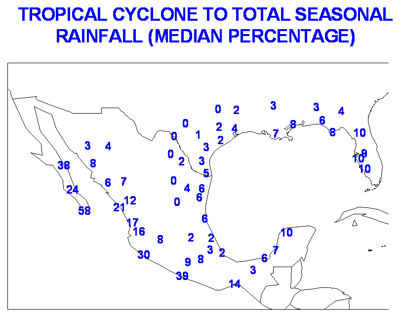
over the years. One-third of the annual rainfall received along the Mexican Riviera
Mexican Riviera
The Mexican Riviera refers collectively to twenty cities and lagoons lying on the western coast of Mexico. Although there are long distances between these cities, they are often referred to as the Mexican Riviera because of their popularity among tourists. Cruise ships often visit three or four of...
and up to half of the rainfall received in Baja California Sur
Baja California Sur
Baja California Sur , is one of the 31 states which, with the Federal District, comprise the 32 Federal Entities of Mexico. Before becoming a state on October 8, 1974, the area was known as the South Territory of Baja California. It has an area of , or 3.57% of the land mass of Mexico and comprises...
is directly attributable to tropical cyclones moving up the west coast of Mexico. The central plateau is shielded from the high rainfall amounts seen on the oceanward slopes of the Sierra Madre Oriental
Sierra Madre Oriental
The Sierra Madre Oriental is a mountain range in northeastern Mexico.-Setting:Spanning the Sierra Madre Oriental runs from Coahuila south through Nuevo León, southwest Tamaulipas, San Luis Potosí, Querétaro, and Hidalgo to northern Puebla, where it joins with the east-west running Eje Volcánico...
and Occidental
Sierra Madre Occidental
The Sierra Madre Occidental is a mountain range in western Mexico.-Setting:The range runs north to south, from just south of the Sonora–Arizona border southeast through eastern Sonora, western Chihuahua, Sinaloa, Durango, Zacatecas, Nayarit, Jalisco, Aguascalientes to Guanajuato, where it joins...
mountain chains.
General characteristics

United States
The United States of America is a federal constitutional republic comprising fifty states and a federal district...
. On an average basis, eastern Pacific tropical cyclones contribute about one-third of the annual rainfall along the Mexican Riviera, and up to one-half of the rainfall seen annually across Baja California Sur. Mexico is twice as likely (18% of the basin total) to be impacted by a Pacific tropical cyclone on its west coast than an Atlantic tropical cyclone on its east coast (9% of the basin total). The three most struck states in Mexico in the 50 years at the end of the 20th century were Baja California Sur
Baja California Sur
Baja California Sur , is one of the 31 states which, with the Federal District, comprise the 32 Federal Entities of Mexico. Before becoming a state on October 8, 1974, the area was known as the South Territory of Baja California. It has an area of , or 3.57% of the land mass of Mexico and comprises...
, Sinaloa
Sinaloa
Sinaloa officially Estado Libre y Soberano de Sinaloa is one of the 31 states which, with the Federal District, comprise the 32 Federal Entities of Mexico. It is divided in 18 municipalities and its capital city is Culiacán Rosales....
, and Quintana Roo
Quintana Roo
Quintana Roo officially Estado Libre y Soberano de Quintana Roo is one of the 31 states which, with the Federal District, comprise the 32 Federal Entities of Mexico. It is divided in 10 municipalities and its capital city is Chetumal....
.
Highest known rainfall amounts

Servicio Meteorológico Nacional
The Servicio Meteorológico Nacional is Mexico's national weather organization. It collects data and issues forecasts, advisories, and warnings for the entire country.-History:...
, which is a part of the National Water Commission, Comisión Nacional del Agua.
| Wettest tropical cyclones in Mexico Highest recorded rainfall totals since 1974 |
|||
|---|---|---|---|
| Rank | Storm and year | Precipitation | |
| (mm) | (in) | ||
| 1 | Wilma 2005 Hurricane Wilma Hurricane Wilma was the most intense tropical cyclone ever recorded in the Atlantic basin. Wilma was the twenty-second storm , thirteenth hurricane, sixth major hurricane, and fourth Category 5 hurricane of the record-breaking 2005 season... |
1576 | 62.05 |
| 2 | Frances 1998 Tropical Storm Frances (1998) Originating over the southwest Caribbean sea on September 4, Tropical Storm Frances became the sixth tropical storm of the 1998 Atlantic hurricane season. The cyclone moved northward through the western Gulf of Mexico, making landfall across the central Texas coastline before recurving across the... |
1119 | 44.06 |
| 3 | Tropical Depression Eleven (1999) | 1098 | 43.23 |
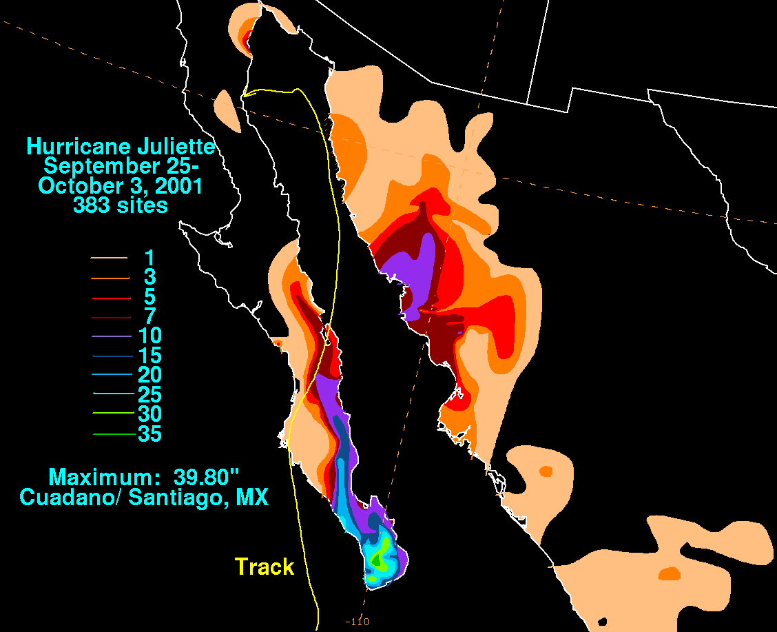
| 4 | Juliette 2001 Hurricane Juliette (2001) Hurricane Juliette was a long lasting Category 4 hurricane in the 2001 Pacific hurricane season. It caused 12 deaths and $400 million in damage when it hit Baja California in late September.-Meteorological history:... |
1011 | 39.80 |
| 5 | Dolly 1996 Hurricane Dolly (1996) Hurricane Dolly was a Category 1 hurricane that struck Mexico. The storm killed 14 people and left many homeless. The fourth named storm and the third hurricane of the 1996 Atlantic hurricane season, Dolly developed from a tropical wave in the west-central Caribbean Sea on August 19... |
950 | 37.41 |
| 6 | Fifi/Orlene 1974 Hurricane Fifi Hurricane Fifi was a catastrophic tropical cyclone that killed between 3,000 and 10,000 people in Honduras in September 1974, ranking it as the fourth deadliest Atlantic hurricane on record. Originating from a strong tropical wave on September 14, the system steadily tracked... |
941 | 37.06 |
| 7 | Alex 2010 | 890 | 35.04 |
| 8 | Gert 1993 Hurricane Gert (1993) Hurricane Gert was a large tropical cyclone that caused heavy flood damage and many deaths throughout Central America and Mexico in September 1993. The seventh named storm and third hurricane of the annual hurricane season, Gert originated from a tropical wave over the southwestern Caribbean... |
805 | 31.69 |
| 9 | Hermine 1980 | 791 | 31.15 |
| 10 | Isidore 2002 Hurricane Isidore Hurricane Isidore was the ninth named storm and the second hurricane in the 2002 Atlantic hurricane season. Isidore was the fifth of eight named storms to occur in September. The tropical cyclone peaked as a Category 3 hurricane, causing damage as well as four fatalities in Jamaica, Cuba, Mexico,... |
774 | 30.49 |
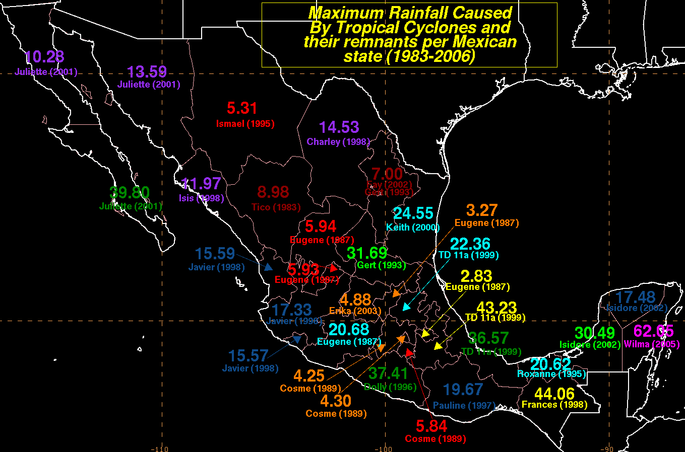
Maximum tropical cyclone rainfall per state for Mexico

Sierra Madre Occidental
The Sierra Madre Occidental is a mountain range in western Mexico.-Setting:The range runs north to south, from just south of the Sonora–Arizona border southeast through eastern Sonora, western Chihuahua, Sinaloa, Durango, Zacatecas, Nayarit, Jalisco, Aguascalientes to Guanajuato, where it joins...
keeps the central plateau
Plateau
In geology and earth science, a plateau , also called a high plain or tableland, is an area of highland, usually consisting of relatively flat terrain. A highly eroded plateau is called a dissected plateau...
free of excessive rainfall, as tropical cyclones originating in the Eastern Pacific Ocean rain themselves out on the upslope sides of the topography. On the eastern side of Mexico, the Sierra Madre Oriental
Sierra Madre Oriental
The Sierra Madre Oriental is a mountain range in northeastern Mexico.-Setting:Spanning the Sierra Madre Oriental runs from Coahuila south through Nuevo León, southwest Tamaulipas, San Luis Potosí, Querétaro, and Hidalgo to northern Puebla, where it joins with the east-west running Eje Volcánico...
has the same orographic effect, this time blocking tropical disturbances making landfall
Landfall (meteorology)
Landfall is the event of a tropical cyclone or a waterspout coming onto land after being over water. When a waterspout makes landfall it is reclassified as a tornado, which can then cause damage inland...
from the Gulf of Mexico
Gulf of Mexico
The Gulf of Mexico is a partially landlocked ocean basin largely surrounded by the North American continent and the island of Cuba. It is bounded on the northeast, north and northwest by the Gulf Coast of the United States, on the southwest and south by Mexico, and on the southeast by Cuba. In...
. State maxima relating to tropical cyclones and their remnants are shown on the right, color coded by amount.
See also
- List of wettest tropical cyclones by country
- Tropical cycloneTropical cycloneA tropical cyclone is a storm system characterized by a large low-pressure center and numerous thunderstorms that produce strong winds and heavy rain. Tropical cyclones strengthen when water evaporated from the ocean is released as the saturated air rises, resulting in condensation of water vapor...
- Tropical cyclone rainfall climatologyTropical cyclone rainfall climatologyA tropical cyclone rainfall climatology is developed to determine rainfall characteristics of past tropical cyclones. A tropical cyclone rainfall climatology can be used to help forecast current or upcoming tropical cyclone impacts. The degree of a tropical cyclone rainfall impact depends upon...
- Tropical cyclone rainfall forecastingTropical cyclone rainfall forecastingTropical cyclone rainfall forecasting involves using scientific models and other tools to predict the precipitation expected in tropical cyclones such as hurricanes and typhoons. Knowledge of tropical cyclone rainfall climatology is helpful in the determination of a tropical cyclone rainfall...

