

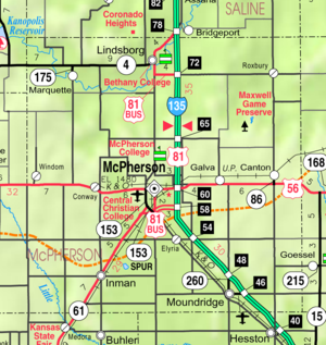
McPherson County, Kansas
Encyclopedia
McPherson County is a county located in the U.S. state
of Kansas
. As of the 2010 census, the county population was 29,180. The largest city and county seat
is McPherson
. The county is named for Civil War General James B. McPherson
. The McPherson Micropolitan Statistical Area includes all of McPherson County.
held a meeting to consider a branch railroad from Florence
. In 1878, Atchison, Topeka and Santa Fe Railway
and parties from Marion County
and McPherson County chartered the Marion and McPherson Railway Company. In 1879, a branch line was built from Florence
to McPherson
, in 1880 it was extended to Lyons
, in 1881 it was extended to Ellinwood
. The line was leased and operated by the Atchison, Topeka and Santa Fe Railway
. The line from Florence
to Marion
, was abandoned in 1968. In 1992, the line from Marion
to McPherson
was sold to Central Kansas Railway
. In 1993, after heavy flood damage, the line from Marion to McPherson was abandoned. The original branch line connected Florence
, Marion
, Canada
, Hillsboro
, Lehigh
, Canton
, Galva
, McPherson
, Conway
, Windom
, Little River
, Mitchell
, Lyons
, Chase
, Ellinwood
.
In 1887, the Chicago, Kansas and Nebraska Railway extended its main line from Herington
to Pratt
. This main line connected Herington, Ramona
, Tampa
, Durham
, Waldeck, Canton
, Galva
, McPherson
, Groveland, Inman
, Medora, Hutchinson
, Whiteside, Partridge
, Arlington
, Langdon
, Turon
, Preston
, Natrona, Pratt
. In 1888, this main line was extended to Liberal
. Later, this line was extended to Tucumcari, New Mexico
and El Paso, Texas
. This line is called the "Golden State Limited".
, Conway
, McPherson
.
, county until 1996, when voters approved the sale of alcoholic liquor by the individual drink with a 30% food sales requirement.
 As of the census
of 2000, there were 29,554 people, 11,205 households, and 7,966 families residing in the county. The population density
was 33 people per square mile (13/km²). There were 11,830 housing units at an average density of 13 per square mile (5/km²). The racial makeup of the county was 96.53% White
, 0.81% Black
or African American
, 0.34% Native American
, 0.32% Asian
, 0.06% Pacific Islander
, 0.79% from other races
, and 1.16% from two or more races. 1.94% of the population were Hispanic
or Latino
of any race. 37.1% were of German
, 12.9% Swedish, 12.1% American
, 6.7% English
and 6.3% Irish
ancestry according to Census 2000.
There were 11,205 households out of which 33.00% had children under the age of 18 living with them, 62.50% were married couples
living together, 6.00% had a female householder with no husband present, and 28.90% were non-families. 25.50% of all households were made up of individuals and 11.80% had someone living alone who was 65 years of age or older. The average household size was 2.49 and the average family size was 2.99.
In the county the population was spread out with 25.40% under the age of 18, 10.30% from 18 to 24, 25.20% from 25 to 44, 21.80% from 45 to 64, and 17.30% who were 65 years of age or older. The median age was 38 years. For every 100 females there were 95.90 males. For every 100 females age 18 and over, there were 92.90 males.
The median income for a household in the county was $41,138, and the median income for a family was $48,243. Males had a median income of $33,530 versus $21,175 for females. The per capita income
for the county was $18,921. About 4.20% of families and 6.60% of the population were below the poverty line, including 5.20% of those under age 18 and 8.10% of those age 65 or over.
. The cities of Lindsborg
and McPherson
are considered governmentally independent and are excluded from the census figures for the townships. In the following table, the population center is the largest city (or cities) included in that township's population total, if it is of a significant size.
District Office In Neighboring County
USA
Maps
U.S. state
A U.S. state is any one of the 50 federated states of the United States of America that share sovereignty with the federal government. Because of this shared sovereignty, an American is a citizen both of the federal entity and of his or her state of domicile. Four states use the official title of...
of Kansas
Kansas
Kansas is a US state located in the Midwestern United States. It is named after the Kansas River which flows through it, which in turn was named after the Kansa Native American tribe, which inhabited the area. The tribe's name is often said to mean "people of the wind" or "people of the south...
. As of the 2010 census, the county population was 29,180. The largest city and county seat
County seat
A county seat is an administrative center, or seat of government, for a county or civil parish. The term is primarily used in the United States....
is McPherson
McPherson, Kansas
McPherson is a city in and the county seat of McPherson County, Kansas, United States, in the central part of the state. As of the 2010 census, the city population was 13,155. The city is named after Union General James Birdseye McPherson, a Civil War general...
. The county is named for Civil War General James B. McPherson
James B. McPherson
James Birdseye McPherson was a career United States Army officer who served as a General in the Union Army during the American Civil War...
. The McPherson Micropolitan Statistical Area includes all of McPherson County.
19th century
As early as 1875, city leaders of MarionMarion, Kansas
Marion is a city in and the county seat of Marion County, Kansas, United States. It was named in honor of Francis Marion, a Brigadier General of the American Revolutionary War, known as the "Swamp Fox". As of the 2010 census, the city population was 1,927....
held a meeting to consider a branch railroad from Florence
Florence, Kansas
Florence is a city in Marion County, Kansas, United States. The city was named after the daughter of former Kansas Governor Samuel J. Crawford. As of the 2010 census, the city population was 465.-19th century:...
. In 1878, Atchison, Topeka and Santa Fe Railway
Atchison, Topeka and Santa Fe Railway
The Atchison, Topeka and Santa Fe Railway , often abbreviated as Santa Fe, was one of the larger railroads in the United States. The company was first chartered in February 1859...
and parties from Marion County
Marion County, Kansas
Marion County is a county located in the U.S. state of Kansas. As of the 2010 census, the county population was 12,660. The county seat is Marion...
and McPherson County chartered the Marion and McPherson Railway Company. In 1879, a branch line was built from Florence
Florence, Kansas
Florence is a city in Marion County, Kansas, United States. The city was named after the daughter of former Kansas Governor Samuel J. Crawford. As of the 2010 census, the city population was 465.-19th century:...
to McPherson
McPherson, Kansas
McPherson is a city in and the county seat of McPherson County, Kansas, United States, in the central part of the state. As of the 2010 census, the city population was 13,155. The city is named after Union General James Birdseye McPherson, a Civil War general...
, in 1880 it was extended to Lyons
Lyons, Kansas
Lyons is a city in and the county seat of Rice County, Kansas, United States. As of the 2010 census, the city population was 3,739.-History:Although Coronado's exact route across the plains is uncertain and has been widely disputed, he and his men are thought to have camped near the present...
, in 1881 it was extended to Ellinwood
Ellinwood, Kansas
Ellinwood is a city in the southeast corner of Barton County, Kansas, United States. As of the 2010 census, the city population was 2,131.-History:...
. The line was leased and operated by the Atchison, Topeka and Santa Fe Railway
Atchison, Topeka and Santa Fe Railway
The Atchison, Topeka and Santa Fe Railway , often abbreviated as Santa Fe, was one of the larger railroads in the United States. The company was first chartered in February 1859...
. The line from Florence
Florence, Kansas
Florence is a city in Marion County, Kansas, United States. The city was named after the daughter of former Kansas Governor Samuel J. Crawford. As of the 2010 census, the city population was 465.-19th century:...
to Marion
Marion, Kansas
Marion is a city in and the county seat of Marion County, Kansas, United States. It was named in honor of Francis Marion, a Brigadier General of the American Revolutionary War, known as the "Swamp Fox". As of the 2010 census, the city population was 1,927....
, was abandoned in 1968. In 1992, the line from Marion
Marion, Kansas
Marion is a city in and the county seat of Marion County, Kansas, United States. It was named in honor of Francis Marion, a Brigadier General of the American Revolutionary War, known as the "Swamp Fox". As of the 2010 census, the city population was 1,927....
to McPherson
McPherson, Kansas
McPherson is a city in and the county seat of McPherson County, Kansas, United States, in the central part of the state. As of the 2010 census, the city population was 13,155. The city is named after Union General James Birdseye McPherson, a Civil War general...
was sold to Central Kansas Railway
Central Kansas Railway
The Central Kansas Railway was a short-line railroad operating of trackage in the U.S. state of Kansas and west to Towner, Colorado, most all of which were former Atchison, Topeka and Santa Fe Railway lines...
. In 1993, after heavy flood damage, the line from Marion to McPherson was abandoned. The original branch line connected Florence
Florence, Kansas
Florence is a city in Marion County, Kansas, United States. The city was named after the daughter of former Kansas Governor Samuel J. Crawford. As of the 2010 census, the city population was 465.-19th century:...
, Marion
Marion, Kansas
Marion is a city in and the county seat of Marion County, Kansas, United States. It was named in honor of Francis Marion, a Brigadier General of the American Revolutionary War, known as the "Swamp Fox". As of the 2010 census, the city population was 1,927....
, Canada
Canada, Kansas
Canada is an unincorporated community in Marion County, Kansas, United States. It is named for many Canadian immigrants coming to the area.-19th century:...
, Hillsboro
Hillsboro, Kansas
Hillsboro is a city in Marion County, Kansas, United States. Hillsboro was named after John Gillespie Hill, who homesteaded in the area in 1871. As of the 2010 census, the city population was 2,993. Hillsboro is home of Tabor College, which has approximately 550 students.-19th century:For...
, Lehigh
Lehigh, Kansas
Lehigh is a city in Marion County, Kansas, United States. As of the 2010 census, the city population was 175.-19th century:For millennia, the land that is currently Kansas was inhabited by Native Americans. In 1803, most of modern Kansas was secured by the United States as part of the Louisiana...
, Canton
Canton, Kansas
Canton is a city in McPherson County, Kansas, United States. As of the 2010 census, the city population was 748.-19th century:As early as 1875, city leaders of Marion held a meeting to consider a branch railroad from Florence. In 1878, Atchison, Topeka and Santa Fe Railway and parties from Marion...
, Galva
Galva, Kansas
Galva is a city in McPherson County, Kansas, in the United States. As of the 2010 census, the city population was 870.-19th century:As early as 1875, city leaders of Marion held a meeting to consider a branch railroad from Florence. In 1878, Atchison, Topeka and Santa Fe Railway and parties from...
, McPherson
McPherson, Kansas
McPherson is a city in and the county seat of McPherson County, Kansas, United States, in the central part of the state. As of the 2010 census, the city population was 13,155. The city is named after Union General James Birdseye McPherson, a Civil War general...
, Conway
Conway, Kansas
Conway is an unincorporated community in southwestern Jackson Township, McPherson County, Kansas, United States. It lies along U.S. Route 56 and a Kansas and Oklahoma Railroad line, west of the city of McPherson, the county seat of McPherson County...
, Windom
Windom, Kansas
Windom is a city in McPherson County, Kansas, United States. As of the 2010 census, the city population was 130.-19th century:In 1878, Atchison, Topeka and Santa Fe Railway and parties from Marion County and McPherson County chartered the Marion and McPherson Railway Company...
, Little River
Little River, Kansas
Little River is a city in Rice County, Kansas, United States. As of the 2010 census, the city population was 557.-History:In 1878, Atchison, Topeka and Santa Fe Railway and parties from Marion County and McPherson County chartered the Marion and McPherson Railway Company...
, Mitchell
Mitchell, Kansas
Mitchell is an unincorporated community in Mitchell Township, Rice County, Kansas, United States. Located about east-northeast of the city of Lyons, the county seat, it lies along local roads a fraction of a mile north of U.S...
, Lyons
Lyons, Kansas
Lyons is a city in and the county seat of Rice County, Kansas, United States. As of the 2010 census, the city population was 3,739.-History:Although Coronado's exact route across the plains is uncertain and has been widely disputed, he and his men are thought to have camped near the present...
, Chase
Chase, Kansas
Chase is a city in Rice County, Kansas, United States. As of the 2010 census, the city population was 477.The city should not be confused with Chase County.-History:...
, Ellinwood
Ellinwood, Kansas
Ellinwood is a city in the southeast corner of Barton County, Kansas, United States. As of the 2010 census, the city population was 2,131.-History:...
.
In 1887, the Chicago, Kansas and Nebraska Railway extended its main line from Herington
Herington, Kansas
Herington is a city in Dickinson and Morris counties in the U.S. state of Kansas. Named after its founder, Monroe Davis Herington. As of the 2010 census, the city population was 2,526.-19th century:...
to Pratt
Pratt, Kansas
Pratt is a city in and the county seat of Pratt County in the U.S. state of Kansas. As of the 2010 census, the city population was 6,835. Pratt is home to Pratt Community College.-19th century:Pratt was founded in 1884 and named after Caleb S...
. This main line connected Herington, Ramona
Ramona, Kansas
Ramona is a city in Marion County, Kansas, United States. As of the 2010 census, the city population was 187.-19th century:For millennia, the land that is currently Kansas was inhabited by Native Americans. The city name is a spanish name. Land ownership of the Ramona area dates back when the...
, Tampa
Tampa, Kansas
Tampa is a city in Marion County, Kansas, United States. As of the 2010 census, the city population was 112.-19th century:For millennia, the land that is currently Kansas was inhabited by Native Americans. In 1803, most of modern Kansas was secured by the United States as part of the Louisiana...
, Durham
Durham, Kansas
Durham is a city in Marion County, Kansas, United States. As of the 2010 census, the city population was 112. Home of Donahue Corporation.-19th century:...
, Waldeck, Canton
Canton, Kansas
Canton is a city in McPherson County, Kansas, United States. As of the 2010 census, the city population was 748.-19th century:As early as 1875, city leaders of Marion held a meeting to consider a branch railroad from Florence. In 1878, Atchison, Topeka and Santa Fe Railway and parties from Marion...
, Galva
Galva, Kansas
Galva is a city in McPherson County, Kansas, in the United States. As of the 2010 census, the city population was 870.-19th century:As early as 1875, city leaders of Marion held a meeting to consider a branch railroad from Florence. In 1878, Atchison, Topeka and Santa Fe Railway and parties from...
, McPherson
McPherson, Kansas
McPherson is a city in and the county seat of McPherson County, Kansas, United States, in the central part of the state. As of the 2010 census, the city population was 13,155. The city is named after Union General James Birdseye McPherson, a Civil War general...
, Groveland, Inman
Inman, Kansas
Inman is a city in McPherson County, Kansas, United States. As of the 2010 census, the city population was 1,377.- History :It was founded in 1887 as Aiken. It was renamed Inman, in 1889, after Inman Lake which is located approximately east of the town...
, Medora, Hutchinson
Hutchinson, Kansas
Hutchinson is the largest city in and the county seat of Reno County, Kansas, United States, northwest of Wichita, on the Arkansas River. It has been home to salt mines since 1887, thus its nickname of "Salt City", but locals call it "Hutch"...
, Whiteside, Partridge
Partridge, Kansas
Partridge is a city in Reno County, Kansas, United States. As of the 2010 census, the city population was 248.-History:In 1887, the Chicago, Kansas and Nebraska Railway built a main line from Herington through Partridge to Pratt. In 1888, this line was extended to Liberal. Later, it was extended...
, Arlington
Arlington, Kansas
Arlington is a city in Reno County, Kansas, United States. As of the 2010 census, the city population was 473.-History:In 1887, the Chicago, Kansas and Nebraska Railway built a main line from Herington through Arlington to Pratt. In 1888, this line was extended to Liberal. Later, it was extended...
, Langdon
Langdon, Kansas
Langdon is a city in Reno County, Kansas, United States. As of the 2010 census, the city population was 42.-History:In 1887, the Chicago, Kansas and Nebraska Railway built a main line from Herington through Langdon to Pratt. In 1888, this line was extended to Liberal. Later, it was extended to...
, Turon
Turon, Kansas
Turon is a city in Reno County, Kansas, United States. As of the 2010 census, the city population was 387.-History:In 1887, the Chicago, Kansas and Nebraska Railway built a main line from Herington through Turon to Pratt. In 1888, this line was extended to Liberal. Later, it was extended to...
, Preston
Preston, Kansas
Preston is a city in Pratt County, Kansas, United States. As of the 2010 census, the city population was 158.-19th century:In 1887, the Chicago, Kansas and Nebraska Railway built a main line from Herington through Preston to Pratt. In 1888, this line was extended to Liberal. Later, it was...
, Natrona, Pratt
Pratt, Kansas
Pratt is a city in and the county seat of Pratt County in the U.S. state of Kansas. As of the 2010 census, the city population was 6,835. Pratt is home to Pratt Community College.-19th century:Pratt was founded in 1884 and named after Caleb S...
. In 1888, this main line was extended to Liberal
Liberal, Kansas
Liberal is the county seat of Seward County, Kansas, United States. As of the 2010 census, the city population was 20,525.- History :S.S. Rogers built the first house in what would become Liberal in 1872. Rogers became famous in the region for giving water to weary travelers...
. Later, this line was extended to Tucumcari, New Mexico
Tucumcari, New Mexico
Tucumcari is a city in and the county seat of Quay County, New Mexico, United States. The population was 5,989 at the 2000 census. Tucumcari was founded in 1901, two years before Quay County was founded.-History:...
and El Paso, Texas
El Paso, Texas
El Paso, is a city in and the county seat of El Paso County, Texas, United States, and lies in far West Texas. In the 2010 census, the city had a population of 649,121. It is the sixth largest city in Texas and the 19th largest city in the United States...
. This line is called the "Golden State Limited".
20th century
The National Old Trails Road, also known as the Ocean-to-Ocean Highway, was established in 1912, and was routed through WindomWindom, Kansas
Windom is a city in McPherson County, Kansas, United States. As of the 2010 census, the city population was 130.-19th century:In 1878, Atchison, Topeka and Santa Fe Railway and parties from Marion County and McPherson County chartered the Marion and McPherson Railway Company...
, Conway
Conway, Kansas
Conway is an unincorporated community in southwestern Jackson Township, McPherson County, Kansas, United States. It lies along U.S. Route 56 and a Kansas and Oklahoma Railroad line, west of the city of McPherson, the county seat of McPherson County...
, McPherson
McPherson, Kansas
McPherson is a city in and the county seat of McPherson County, Kansas, United States, in the central part of the state. As of the 2010 census, the city population was 13,155. The city is named after Union General James Birdseye McPherson, a Civil War general...
.
Law and government
Following amendment to the Kansas Constitution in 1986, the county remained a prohibition, or "dry"Dry county
A dry county is a county in the United States whose government forbids the sale of alcoholic beverages. Some prohibit off-premises sale, some prohibit on-premises sale, and some prohibit both. Hundreds of dry counties exist across the United States, almost all of them in the South...
, county until 1996, when voters approved the sale of alcoholic liquor by the individual drink with a 30% food sales requirement.
Geography
According to the 2000 census, the county has a total area of 901.24 square miles (2,334.2 km²), of which 899.71 square miles (2,330.2 km²) (or 99.83%) is land and 1.52 square miles (3.9 km²) (or 0.17%) is water.Adjacent counties
- Saline CountySaline County, KansasSaline County is a county located in the U.S. state of Kansas. As of the 2010 census, the county population was 55,606...
(north) - Dickinson CountyDickinson County, KansasDickinson County is a county located in Central Kansas, in the Central United States. As of the 2010 census, the county population was 19,754. Its county seat and most populous city is Abilene. It was named in honor of Daniel S. Dickinson.-19th century:In 1887, Mr. Herington successfully got...
(northeast) - Marion CountyMarion County, KansasMarion County is a county located in the U.S. state of Kansas. As of the 2010 census, the county population was 12,660. The county seat is Marion...
(east) - Harvey CountyHarvey County, KansasHarvey County is a county located in South Central Kansas, in the Central United States. As of the 2010 census, the county population was 34,684. Its county seat and most populous city is Newton. The county is a part of the Wichita Metropolitan Statistical Area which also includes Butler,...
(southeast) - Reno CountyReno County, KansasReno County is a county located in the U.S. state of Kansas. The county's population was 64,511 for the 2010 census. The largest city and county seat is Hutchinson. The Hutchinson Micropolitan Statistical Area includes all of Reno County.-19th century:In 1887, the Chicago, Kansas and Nebraska...
(southwest) - Rice CountyRice County, KansasRice County is a county located in the U.S. state of Kansas; it was named in memory of Samuel Allen Rice, Brigadier-General, United States volunteers, killed April 30, 1864, at Jenkins Ferry, Arkansas. As of the 2010 census, the county population was 10,083...
(west) - Ellsworth CountyEllsworth County, KansasEllsworth County is a county located in Central Kansas, in the Central United States. As of the 2010 census, the county population was 6,497. Its county seat and most populous city is Ellsworth.-19th century:...
(northwest)
Demographics
Census
A census is the procedure of systematically acquiring and recording information about the members of a given population. It is a regularly occurring and official count of a particular population. The term is used mostly in connection with national population and housing censuses; other common...
of 2000, there were 29,554 people, 11,205 households, and 7,966 families residing in the county. The population density
Population density
Population density is a measurement of population per unit area or unit volume. It is frequently applied to living organisms, and particularly to humans...
was 33 people per square mile (13/km²). There were 11,830 housing units at an average density of 13 per square mile (5/km²). The racial makeup of the county was 96.53% White
Race (United States Census)
Race and ethnicity in the United States Census, as defined by the Federal Office of Management and Budget and the United States Census Bureau, are self-identification data items in which residents choose the race or races with which they most closely identify, and indicate whether or not they are...
, 0.81% Black
Race (United States Census)
Race and ethnicity in the United States Census, as defined by the Federal Office of Management and Budget and the United States Census Bureau, are self-identification data items in which residents choose the race or races with which they most closely identify, and indicate whether or not they are...
or African American
Race (United States Census)
Race and ethnicity in the United States Census, as defined by the Federal Office of Management and Budget and the United States Census Bureau, are self-identification data items in which residents choose the race or races with which they most closely identify, and indicate whether or not they are...
, 0.34% Native American
Race (United States Census)
Race and ethnicity in the United States Census, as defined by the Federal Office of Management and Budget and the United States Census Bureau, are self-identification data items in which residents choose the race or races with which they most closely identify, and indicate whether or not they are...
, 0.32% Asian
Race (United States Census)
Race and ethnicity in the United States Census, as defined by the Federal Office of Management and Budget and the United States Census Bureau, are self-identification data items in which residents choose the race or races with which they most closely identify, and indicate whether or not they are...
, 0.06% Pacific Islander
Race (United States Census)
Race and ethnicity in the United States Census, as defined by the Federal Office of Management and Budget and the United States Census Bureau, are self-identification data items in which residents choose the race or races with which they most closely identify, and indicate whether or not they are...
, 0.79% from other races
Race (United States Census)
Race and ethnicity in the United States Census, as defined by the Federal Office of Management and Budget and the United States Census Bureau, are self-identification data items in which residents choose the race or races with which they most closely identify, and indicate whether or not they are...
, and 1.16% from two or more races. 1.94% of the population were Hispanic
Race (United States Census)
Race and ethnicity in the United States Census, as defined by the Federal Office of Management and Budget and the United States Census Bureau, are self-identification data items in which residents choose the race or races with which they most closely identify, and indicate whether or not they are...
or Latino
Race (United States Census)
Race and ethnicity in the United States Census, as defined by the Federal Office of Management and Budget and the United States Census Bureau, are self-identification data items in which residents choose the race or races with which they most closely identify, and indicate whether or not they are...
of any race. 37.1% were of German
Germans
The Germans are a Germanic ethnic group native to Central Europe. The English term Germans has referred to the German-speaking population of the Holy Roman Empire since the Late Middle Ages....
, 12.9% Swedish, 12.1% American
United States
The United States of America is a federal constitutional republic comprising fifty states and a federal district...
, 6.7% English
English people
The English are a nation and ethnic group native to England, who speak English. The English identity is of early mediaeval origin, when they were known in Old English as the Anglecynn. England is now a country of the United Kingdom, and the majority of English people in England are British Citizens...
and 6.3% Irish
Irish people
The Irish people are an ethnic group who originate in Ireland, an island in northwestern Europe. Ireland has been populated for around 9,000 years , with the Irish people's earliest ancestors recorded having legends of being descended from groups such as the Nemedians, Fomorians, Fir Bolg, Tuatha...
ancestry according to Census 2000.
There were 11,205 households out of which 33.00% had children under the age of 18 living with them, 62.50% were married couples
Marriage
Marriage is a social union or legal contract between people that creates kinship. It is an institution in which interpersonal relationships, usually intimate and sexual, are acknowledged in a variety of ways, depending on the culture or subculture in which it is found...
living together, 6.00% had a female householder with no husband present, and 28.90% were non-families. 25.50% of all households were made up of individuals and 11.80% had someone living alone who was 65 years of age or older. The average household size was 2.49 and the average family size was 2.99.
In the county the population was spread out with 25.40% under the age of 18, 10.30% from 18 to 24, 25.20% from 25 to 44, 21.80% from 45 to 64, and 17.30% who were 65 years of age or older. The median age was 38 years. For every 100 females there were 95.90 males. For every 100 females age 18 and over, there were 92.90 males.
The median income for a household in the county was $41,138, and the median income for a family was $48,243. Males had a median income of $33,530 versus $21,175 for females. The per capita income
Per capita income
Per capita income or income per person is a measure of mean income within an economic aggregate, such as a country or city. It is calculated by taking a measure of all sources of income in the aggregate and dividing it by the total population...
for the county was $18,921. About 4.20% of families and 6.60% of the population were below the poverty line, including 5.20% of those under age 18 and 8.10% of those age 65 or over.
Incorporated cities
Name and population (2010):- McPhersonMcPherson, KansasMcPherson is a city in and the county seat of McPherson County, Kansas, United States, in the central part of the state. As of the 2010 census, the city population was 13,155. The city is named after Union General James Birdseye McPherson, a Civil War general...
, 13,155 - LindsborgLindsborg, KansasLindsborg is a city in McPherson County, Kansas, USA. As of the 2010 census, the city population was 3,458. It is known for its association with Swedish heritage and the biennial Svensk Hyllningsfest...
, 3,458 - MoundridgeMoundridge, KansasMoundridge is a city in McPherson County, Kansas, United States. As of the 2010 census, the city population was 1,737. The city is named for the settlement that became the incorporated city in 1887 located in Mound Township.-History:...
, 1,737 - InmanInman, KansasInman is a city in McPherson County, Kansas, United States. As of the 2010 census, the city population was 1,377.- History :It was founded in 1887 as Aiken. It was renamed Inman, in 1889, after Inman Lake which is located approximately east of the town...
, 1,377 - GalvaGalva, KansasGalva is a city in McPherson County, Kansas, in the United States. As of the 2010 census, the city population was 870.-19th century:As early as 1875, city leaders of Marion held a meeting to consider a branch railroad from Florence. In 1878, Atchison, Topeka and Santa Fe Railway and parties from...
, 870 - CantonCanton, KansasCanton is a city in McPherson County, Kansas, United States. As of the 2010 census, the city population was 748.-19th century:As early as 1875, city leaders of Marion held a meeting to consider a branch railroad from Florence. In 1878, Atchison, Topeka and Santa Fe Railway and parties from Marion...
, 748 - MarquetteMarquette, KansasMarquette is a city located in the northwest corner of McPherson County, Kansas, United States, between K-4 and the Smoky Hill River. The city was settled by Swedish immigrants and chartered on February 9, 1874...
, 641 - WindomWindom, KansasWindom is a city in McPherson County, Kansas, United States. As of the 2010 census, the city population was 130.-19th century:In 1878, Atchison, Topeka and Santa Fe Railway and parties from Marion County and McPherson County chartered the Marion and McPherson Railway Company...
, 130
Unincorporated communities
- ConwayConway, KansasConway is an unincorporated community in southwestern Jackson Township, McPherson County, Kansas, United States. It lies along U.S. Route 56 and a Kansas and Oklahoma Railroad line, west of the city of McPherson, the county seat of McPherson County...
- ElyriaElyria, KansasElyria is an unincorporated community in McPherson County, Kansas, located 4 mi south of McPherson in the Central Standard time zone at an elevation of 1,486 feet. A post office was in existence there from 1887 until 1954 after it was moved from King City.Elyria is home of the Elyria...
- Groveland
- RoxburyRoxbury, KansasRoxbury is an unincorporated community about 14.8 miles east of Lindsborg in McPherson County, Kansas, United States. The population was 100 at the 1910 census. The original name for the area was Colfax City but the name was changed to Roxbury on March 4, 1875 due to an act of...
Ghost towns
- Battle Hill
- Christian
- Doles Park
- Elivon
- King City
Townships
McPherson County is divided into twenty-five townshipsCivil township
A civil township is a widely used unit of local government in the United States, subordinate to, and geographic divisions of, a county. Specific responsibilities and the degree of autonomy vary based on each state. Civil townships are distinct from survey townships, but in states that have both,...
. The cities of Lindsborg
Lindsborg, Kansas
Lindsborg is a city in McPherson County, Kansas, USA. As of the 2010 census, the city population was 3,458. It is known for its association with Swedish heritage and the biennial Svensk Hyllningsfest...
and McPherson
McPherson, Kansas
McPherson is a city in and the county seat of McPherson County, Kansas, United States, in the central part of the state. As of the 2010 census, the city population was 13,155. The city is named after Union General James Birdseye McPherson, a Civil War general...
are considered governmentally independent and are excluded from the census figures for the townships. In the following table, the population center is the largest city (or cities) included in that township's population total, if it is of a significant size.
| Township | FIPS | Population center |
Population | Population density /km² (/sq mi) |
Land area km² (sq mi) | Water area km² (sq mi) | Water % | Geographic coordinates |
|---|---|---|---|---|---|---|---|---|
| Battle Hill | 04550 | 91 | 1 (3) | 93 (36) | 0 (0) | 0.33% | 38°29′2"N 97°25′22"W | |
| Bonaville | 07925 | 66 | 1 (2) | 93 (36) | 0 (0) | 0.34% | 38°32′57"N 97°30′34"W | |
| Canton | 10500 | 1,090 | 12 (30) | 93 (36) | 0 (0) | 0.02% | 38°23′21"N 97°25′36"W | |
| Castle | 10950 | 225 | 2 (6) | 93 (36) | 0 (0) | 0.12% | 38°23′9"N 97°52′44"W | |
| Delmore | 17575 | 138 | 1 (4) | 93 (36) | 0 (0) | 0.15% | 38°28′43"N 97°33′17"W | |
| Empire | 21200 | 1,178 | 13 (33) | 94 (36) | 0 (0) | 0 % | 38°23′12"N 97°32′7"W | |
| Groveland | 29150 | 234 | 2 (6) | 94 (36) | 0 (0) | 0.12% | 38°17′55"N 97°44′37"W | |
| Gypsum Creek | 29325 | 215 | 2 (6) | 93 (36) | 0 (0) | 0.11% | 38°33′32"N 97°26′12"W | |
| Harper | 30225 | 137 | 1 (4) | 93 (36) | 0 (0) | 0.17% | 38°28′55"N 97°45′50"W | |
| Hayes | 30950 | 287 | 3 (8) | 94 (36) | 0 (0) | 0 % | 38°17′55"N 97°52′54"W | |
| Jackson | 34850 | 198 | 2 (6) | 93 (36) | 0 (0) | 0.49% | 38°22′33"N 97°46′48"W | |
| King City | 36900 | 544 | 6 (15) | 93 (36) | 0 (0) | 0.13% | 38°18′51"N 97°39′8"W | |
| Little Valley | 41600 | 475 | 5 (13) | 93 (36) | 0 (0) | 0.02% | 38°13′38"N 97°52′32"W | |
| Lone Tree | 42525 | 486 | 5 (13) | 94 (36) | 0 (0) | 0 % | 38°17′37"N 97°32′48"W | |
| McPherson | 43975 | 618 | 8 (21) | 77 (30) | 0 (0) | 0.23% | 38°23′24"N 97°38′57"W | |
| Marquette | 44950 | 776 | 8 (22) | 93 (36) | 0 (0) | 0.16% | 38°33′9"N 97°51′30"W | |
| Meridian | 45975 | 341 | 4 (9) | 94 (36) | 0 (0) | 0 % | 38°12′43"N 97°26′8"W | |
| Mound | 48675 | 2,104 | 23 (59) | 93 (36) | 0 (0) | 0.17% | 38°12′24"N 97°31′22"W | |
| New Gottland | 50350 | 354 | 4 (10) | 93 (36) | 0 (0) | 0.38% | 38°28′29"N 97°38′21"W | |
| Smoky Hill | 66025 | 297 | 3 (9) | 89 (34) | 0 (0) | 0.05% | 38°34′35"N 97°38′59"W | |
| South Sharps Creek | 67000 | 112 | 1 (3) | 93 (36) | 0 (0) | 0.18% | 38°28′21"N 97°52′11"W | |
| Spring Valley | 67750 | 373 | 4 (10) | 94 (36) | 0 (0) | 0.03% | 38°18′2"N 97°25′21"W | |
| Superior | 69475 | 1,640 | 18 (46) | 92 (36) | 1 (0) | 0.72% | 38°13′28"N 97°46′1"W | |
| Turkey Creek | 71700 | 294 | 3 (8) | 93 (36) | 0 (0) | 0 % | 38°13′10"N 97°38′23"W | |
| Union | 72225 | 190 | 2 (5) | 93 (36) | 0 (0) | 0.20% | 38°33′12"N 97°44′59"W |
Education
Unified school districts
- USD 400, Smoky Valley
- LindsborgLindsborg, KansasLindsborg is a city in McPherson County, Kansas, USA. As of the 2010 census, the city population was 3,458. It is known for its association with Swedish heritage and the biennial Svensk Hyllningsfest...
, MarquetteMarquette, KansasMarquette is a city located in the northwest corner of McPherson County, Kansas, United States, between K-4 and the Smoky Hill River. The city was settled by Swedish immigrants and chartered on February 9, 1874...
, Rural Areas
- Lindsborg
- USD 418, McPherson
- McPhersonMcPherson, KansasMcPherson is a city in and the county seat of McPherson County, Kansas, United States, in the central part of the state. As of the 2010 census, the city population was 13,155. The city is named after Union General James Birdseye McPherson, a Civil War general...
, Rural Areas
- McPherson
- USD 419, Canton-Galva
- CantonCanton, KansasCanton is a city in McPherson County, Kansas, United States. As of the 2010 census, the city population was 748.-19th century:As early as 1875, city leaders of Marion held a meeting to consider a branch railroad from Florence. In 1878, Atchison, Topeka and Santa Fe Railway and parties from Marion...
, GalvaGalva, KansasGalva is a city in McPherson County, Kansas, in the United States. As of the 2010 census, the city population was 870.-19th century:As early as 1875, city leaders of Marion held a meeting to consider a branch railroad from Florence. In 1878, Atchison, Topeka and Santa Fe Railway and parties from...
, Rural Areas
- Canton
- USD 423, Moundridge
- MoundridgeMoundridge, KansasMoundridge is a city in McPherson County, Kansas, United States. As of the 2010 census, the city population was 1,737. The city is named for the settlement that became the incorporated city in 1887 located in Mound Township.-History:...
, Rural Areas
- Moundridge
- USD 448, Inman
- InmanInman, KansasInman is a city in McPherson County, Kansas, United States. As of the 2010 census, the city population was 1,377.- History :It was founded in 1887 as Aiken. It was renamed Inman, in 1889, after Inman Lake which is located approximately east of the town...
, Rural Areas
- Inman
District Office In Neighboring County
- USD 411, Goessel
- Rural Areas
- USD 444, Little River-Windom
- WindomWindom, KansasWindom is a city in McPherson County, Kansas, United States. As of the 2010 census, the city population was 130.-19th century:In 1878, Atchison, Topeka and Santa Fe Railway and parties from Marion County and McPherson County chartered the Marion and McPherson Railway Company...
, Rural Areas
- Windom
Colleges
- McPherson CollegeMcPherson CollegeMcPherson College was chartered in 1887 by the leaders of the Church of the Brethren. The college provides a career-oriented liberal arts education...
, in McPhersonMcPherson, KansasMcPherson is a city in and the county seat of McPherson County, Kansas, United States, in the central part of the state. As of the 2010 census, the city population was 13,155. The city is named after Union General James Birdseye McPherson, a Civil War general... - Bethany CollegeBethany College (Kansas)Bethany College is a small liberal arts college located in Lindsborg, Kansas and is affiliated with the Evangelical Lutheran Church in America . The college's mission is to educate, develop and challenge individuals to reach for truth and excellence as they lead loves of faith, learning and service...
, in LindsborgLindsborg, KansasLindsborg is a city in McPherson County, Kansas, USA. As of the 2010 census, the city population was 3,458. It is known for its association with Swedish heritage and the biennial Svensk Hyllningsfest...
. - Central Christian CollegeCentral Christian CollegeCentral Christian College of Kansas , an evangelical Christian college embracing the Wesleyan tradition, is affiliated with the Free Methodist Church. While accepting and supporting the doctrines of the Free Methodist Church, Central opens its door and solicits students, regardless of handicap,...
, in McPhersonMcPherson, KansasMcPherson is a city in and the county seat of McPherson County, Kansas, United States, in the central part of the state. As of the 2010 census, the city population was 13,155. The city is named after Union General James Birdseye McPherson, a Civil War general...
Museums
- Birger Sandzén Memorial Gallery, in LindsborgLindsborg, KansasLindsborg is a city in McPherson County, Kansas, USA. As of the 2010 census, the city population was 3,458. It is known for its association with Swedish heritage and the biennial Svensk Hyllningsfest...
- McCormick-Deering Days Museum, in InmanInman, KansasInman is a city in McPherson County, Kansas, United States. As of the 2010 census, the city population was 1,377.- History :It was founded in 1887 as Aiken. It was renamed Inman, in 1889, after Inman Lake which is located approximately east of the town...
- McPherson MuseumMcPherson MuseumThe McPherson Museum of McPherson, Kansas, is a local history museum that preserves the historical and cultural heritage of the McPherson community.-The Museum:...
, in McPhersonMcPherson, KansasMcPherson is a city in and the county seat of McPherson County, Kansas, United States, in the central part of the state. As of the 2010 census, the city population was 13,155. The city is named after Union General James Birdseye McPherson, a Civil War general... - McPherson County Old Mill Museum, in LindsborgLindsborg, KansasLindsborg is a city in McPherson County, Kansas, USA. As of the 2010 census, the city population was 3,458. It is known for its association with Swedish heritage and the biennial Svensk Hyllningsfest...
See also
- National Register of Historic Places listings in McPherson County, KansasNational Register of Historic Places listings in McPherson County, KansasThis is a list of the National Register of Historic Places listings in McPherson County, Kansas.This is intended to be a complete list of the properties and districts on the National Register of Historic Places in McPherson County, Kansas, United States...
Further reading
Kansas- History of the State of Kansas; William G. Cutler; A.T. Andreas Publisher; 1883. (Online HTML eBook)
- Kansas : A Cyclopedia of State History, Embracing Events, Institutions, Industries, Counties, Cities, Towns, Prominent Persons, Etc; 3 Volumes; Frank W. Blackmar; Standard Publishing Co; 944 / 955 / 824 pages; 1912. (Volume1 - Download 54MB PDF eBook), (Volume2 - Download 53MB PDF eBook), (Volume3 - Download 33MB PDF eBook)
USA
- The Story of the Marking of the Santa Fe TrailSanta Fe TrailThe Santa Fe Trail was a 19th-century transportation route through central North America that connected Missouri with Santa Fe, New Mexico. Pioneered in 1822 by William Becknell, it served as a vital commercial and military highway until the introduction of the railroad to Santa Fe in 1880...
by the Daughters of the American RevolutionDaughters of the American RevolutionThe Daughters of the American Revolution is a lineage-based membership organization for women who are descended from a person involved in United States' independence....
in Kansas and the State of Kansas; Almira Cordry; Crane Co; 164 pages; 1915. (Download 4MB PDF eBook) - The National Old Trails Road To Southern California, Part 1 (LA to KC); Automobile Club Of Southern California; 64 pages; 1916. (Download 6.8MB PDF eBook)
External links
County- McPherson County - Official Website
- McPherson County - Directory of Public Officials
- McPherson County - Information
Maps
- McPherson County Map, KDOT
- Kansas Highway Map, KDOT
- Kansas Railroad Map, KDOT
- Kansas School District Boundary Map, KSDE