
Mayburgh Henge
Encyclopedia

Cumbria
Cumbria , is a non-metropolitan county in North West England. The county and Cumbria County Council, its local authority, came into existence in 1974 after the passage of the Local Government Act 1972. Cumbria's largest settlement and county town is Carlisle. It consists of six districts, and in...
in northern England
England
England is a country that is part of the United Kingdom. It shares land borders with Scotland to the north and Wales to the west; the Irish Sea is to the north west, the Celtic Sea to the south west, with the North Sea to the east and the English Channel to the south separating it from continental...
. Mayburgh Henge is just outside the village of Eamont Bridge
Eamont Bridge
Eamont Bridge is a small village immediately to the south of Penrith, Cumbria.The village is named after the River Eamont and straddles the boundary between the ancient counties of Cumberland and Westmorland...
close to the confluence of the Rivers Eamont
River Eamont
The River Eamont is a river in Cumbria, England and one of the major tributaries of the River Eden.The river is formed by the outflow from Ullswater in the Lake District, later augmented by Dacre Beck from the west and the River Lowther which carries the water from Haweswater north to the Eamont at...
and Lowther
River Lowther
The River Lowther flows through Cumbria in England. It is a tributary of the River Eamont which in turn is a tributary of the River Eden which flows into the Solway Firth near Carlisle....
around 1 mile south of Penrith
Penrith, Cumbria
Penrith was an urban district between 1894 and 1974, when it was merged into Eden District.The authority's area was coterminous with the civil parish of Penrith although when the council was abolished Penrith became an unparished area....
, just a few hundred yards from the M6 motorway
M6 motorway
The M6 motorway runs from junction 19 of the M1 at the Catthorpe Interchange, near Rugby via Birmingham then heads north, passing Stoke-on-Trent, Manchester, Preston, Carlisle and terminating at the Gretna junction . Here, just short of the Scottish border it becomes the A74 which continues to...
.
Mayburgh Henge is in the care of English Heritage
English Heritage
English Heritage . is an executive non-departmental public body of the British Government sponsored by the Department for Culture, Media and Sport...
. It is a Scheduled Ancient Monument - number 12002.
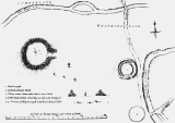
The site consists of a single circular bank built using cobble stones from the nearby rivers. The bank is up to 15 feet (6.5 metres) high, and 50 metres across its base with a diameter of around 383 feet (117 metres). Contained within it is a single monolith 9 feet (2.8 metres) high. According to Thomas Pennant, in the early 18th century there had been four standing stones in the centre (marked on his 1769 plan, shown here), and a further four at the entrance, but his contemporary Robert Hutchinson, writing in 1773, gave a slightly different version:
"The inhabitants in the neighbourhood say, that within the memory of man, two other stones of similar nature, and placed in a kind of angular figure with the stone now remaining, were to be seen there, but as they were hurtful to the ground, were destroyed and removed."
No proper excavation has been done at Mayburgh, so it is difficult to date the henge with any certainty, but the presence of Neolithic and Bronze axes found near the site indicate a date in the Neolithic
Neolithic
The Neolithic Age, Era, or Period, or New Stone Age, was a period in the development of human technology, beginning about 9500 BC in some parts of the Middle East, and later in other parts of the world. It is traditionally considered as the last part of the Stone Age...
or Bronze Age
Bronze Age
The Bronze Age is a period characterized by the use of copper and its alloy bronze as the chief hard materials in the manufacture of some implements and weapons. Chronologically, it stands between the Stone Age and Iron Age...
. In 1992 a magnetometer survey was carried out by Geophysical Surveys of Bradford and English Heritage to confirm any stone settings within the interior and to assess the presence of a ditch, internal or external.
There is no obvious explanation for why Mayburgh was built, but the fact that it is close to the confluence of the rivers Lowther and Eamont have given rise to the theory that it was once a trade centre on a route for stone axe trade from the Neolithic axe factory at Langdale.
Eden Arts Council erected a granite obelisk nearby, called the "Millennium Stone" to mark the year 2000.
The Henge forms part of a selection of prehistoric and historic remains in the surrounding area, including:
- King Arthur's Round Table HengeKing Arthur's Round Table, CumbriaKing Arthur's Round Table is a Neolithic henge in the village of Eamont Bridge within the English county of Cumbria, around 2 km south east of Penrith. The site is free to visitors and is under the control of English Heritage....
, 400 metres from Mayburgh Henge. - Brocavum Roman Camp, BroughamBrougham, CumbriaBrougham is a small village and civil parish on the outskirts of Penrith in the Eden District of Cumbria, England...
- Brougham CastleBrougham CastleBrougham Castle is a medieval building about south-east of Penrith, Cumbria, England. It is a Scheduled Monument and open to the public. Founded by Robert de Vieuxpont in the early 13th century on the site of a Roman fort, it sits near the confluence of the rivers Eamont and Lowther...
- Shap AbbeyShap AbbeyShap Abbey was a monastic religious house of the Premonstratensian order on the western bank of the River Lowther in the civil parish of Shap Rural, around from the village of Shap, in the Eden District of Cumbria, England...
, near ShapShapShap is a linear village and civil parish located amongst fells and isolated dales in Eden district, Cumbria, England. The village lies along the A6 road and the West Coast Main Line, and is near to the M6 motorway...