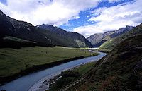
Matukituki River
Encyclopedia

Southern Alps
The Southern Alps is a mountain range extending along much of the length of New Zealand's South Island, reaching its greatest elevations near the island's western side...
of New Zealand
New Zealand
New Zealand is an island country in the south-western Pacific Ocean comprising two main landmasses and numerous smaller islands. The country is situated some east of Australia across the Tasman Sea, and roughly south of the Pacific island nations of New Caledonia, Fiji, and Tonga...
's South Island
South Island
The South Island is the larger of the two major islands of New Zealand, the other being the more populous North Island. It is bordered to the north by Cook Strait, to the west by the Tasman Sea, to the south and east by the Pacific Ocean...
. It flows for 30 kilometres from Mount Aspiring National Park
Mount Aspiring National Park
Mount Aspiring National Park is located in the Southern Alps of the South Island of New Zealand, north of Fiordland National Park, and between Otago and south Westland. The park forms part of the Te Wahipounamu World Heritage site.-Geography:...
into the southwestern edge of Lake Wanaka
Lake Wanaka
Lake Wanaka is located in the Otago region of New Zealand, at an altitude of 300 metres. Covering an area of , it is New Zealand's fourth largest lake, and estimated to be more than deep...
just after passing under the West Wanaka bridge.
The Matukituki River valley is home to a ski resort (Treble Cone
Treble Cone
Treble Cone is a commercial skifield near Wanaka, New Zealand.Treble Cone boasts the longest vertical rise in the Southern Lakes and spectacular views over Lake Wanaka and Mount Aspiring/Tititea...
), a jetboat operator (River Journeys) and numerous tramping (walking) trails providing access to most notably the Rob Roy Glacier and the Dart Saddle.
Maori called Mount Aspiring, Tititea, meaning steep peak of glistening white. Throughout the year the maori would come from Foveaux Strait and Coastal Otago to the inland lakes to collect Kakapo
Kakapo
The Kakapo , Strigops habroptila , also called owl parrot, is a species of large, flightless nocturnal parrot endemic to New Zealand...
(night parrot), Kākā
Kaka
The New Zealand Kaka, also known as Kākā, is a New Zealand parrot endemic to the native forests of New Zealand.-Description:...
, Kereru
Kereru
The New Zealand Pigeon or kererū is a bird endemic to New Zealand. Māori call it Kererū in most of the country but kūkupa and kūkū in some parts of the North Island, particularly in Northland...
(wood pigeon) and Tui
Tui (bird)
The tui is an endemic passerine bird of New Zealand. It is one of the largest members of the diverse honeyeater family....
from the forest. For the first 200 years of Maori settlement there would also have been moa
Moa
The moa were eleven species of flightless birds endemic to New Zealand. The two largest species, Dinornis robustus and Dinornis novaezelandiae, reached about in height with neck outstretched, and weighed about ....
along the forest edges.
Kati Mamoe and Kai Tahu both had named settlements around the shores of Lakes Wanaka and Hawea, including Nehenehe (literally meaning forest), on the north side of the mouth of the Matukituki River. There are several sites on the lake shore with ovens for cooking ti rakau (cabbage tree) roots.
The first European to see Mount Aspiring/Tititea was government surveyor John Turnbull Thompson in 1857. The first European to explore the West Matukituki Valley was James Hector in 1862. Farming began in the valley in the 1870s.
Most of the Southern Alps/Ka Tiritiri o te Moana started over 220 million years ago as sediment and rock on top of volcanic rocks on the seafloor. Under intense heat and pressure the rock was consolidated, then uplifted to form the Main Divide. The present landscape was shaped by glacial processes during the Ice Ages, when huge glaciers filled and scoured out the valleys. Beech is the dominant forest in the Matukituki Valley. Red beech prefers warm valley sites, and is common just below Aspiring Hut. Mountain beech dominates the drier, eastern end of the valley, while silver beech increases towards the wetter, western end. Ferns and mosses are a feature of the usually open forest. Above the tree line, at about 1100 metres, stunted, sub-alpine shrub land gives way to alpine tussock grasslands and fell fields.
Insect-eating birds such as fantail/piwakawaka, tomtit/miromiro and Rifleman
Rifleman (bird)
The Rifleman is a small insectivorous passerine bird that is endemic to New Zealand. It belongs to the Acanthisittidae family, also known as the New Zealand wrens, of which it is one of only two surviving species...
/titipounamu, thrive in beech forest and seed-eating Kakariki
Kakariki
The three species of Kākāriki or New Zealand parakeets are the most common species of parakeet in the genus Cyanoramphus, family Psittacidae. The birds' Māori name, which is the most commonly used, means "small parrot"....
(parakeet) are common in the red beech. The paradise shelduck/putakitaki is a conspicuous and noisy feature of the river flats, and in summer spur-winged plover and oystercatcher/torea are common on farmland and along the drive from Wanaka.

