

Mathur Aqueduct
Encyclopedia
| Mathur Hanging Trough | |
| Length of flume | 1240 ft (378 m) |
| Width | 7.5 ft (2.3 m) |
| Height of trough | 7 ft (2.1 m) |
| Velocity | 5.1 ft/s (1.55 m/s) |
| Discharge | 204 ft³/s (5.8 m³/s) |
| No. of span pillars | 28 |
| Length of span | 40 ft (12.2 m) |
| Bed level, trough at start | 91 in (2.31 m) |
| Bed level, trough at end | 90 in (2.29 m) |
| Maximum height above ground level | 115 ft (35 m) |
| Construction cost | Rs. 12.90 lakh Lakh A lakh is a unit in the Indian numbering system equal to one hundred thousand . It is widely used both in official and other contexts in Pakistan, Bangladesh, India, Maldives, Nepal, Sri Lanka, Myanmar and is often used in Indian English.-Usage:... s - in 1966 |
Mathur Aqueduct or Mathur Hanging Trough, is an Aqueduct
Aqueduct
An aqueduct is a water supply or navigable channel constructed to convey water. In modern engineering, the term is used for any system of pipes, ditches, canals, tunnels, and other structures used for this purpose....
in Southern India
India
India , officially the Republic of India , is a country in South Asia. It is the seventh-largest country by geographical area, the second-most populous country with over 1.2 billion people, and the most populous democracy in the world...
, in Kanyakumari District
Kanyakumari District
Kanyakumari District ) is a district of Tamil Nadu state, India and is the southernmost land area of mainland India.The district is the second most urbanised district in Tamilnadu, next only to Chennai and ahead of Coimbatore. It also has the highest literacy and education levels in the...
of Tamilnadu state. Built over the Pahrali River (also called Parazhiyar), it takes its name from Mathur, a hamlet near the Aqueduct
Aqueduct
An aqueduct is a water supply or navigable channel constructed to convey water. In modern engineering, the term is used for any system of pipes, ditches, canals, tunnels, and other structures used for this purpose....
, which is at a distance of about 3 kilometres from Thiruvattar
Thiruvattar
Thiruvattaru is a panchayat town in Kanniyakumari district in the Indian state of Tamil Nadu.-About the town:This town is situated 6 km north-east of Marthandam and 30 km north-west of Nagercoil. The two main rivers Pahrali River and Kothai surround the village and join in Moovattumugam,...
town and about 60 km from Kanyakumari, the southernmost town of India
India
India , officially the Republic of India , is a country in South Asia. It is the seventh-largest country by geographical area, the second-most populous country with over 1.2 billion people, and the most populous democracy in the world...
. It is one of the longest and highest aqueducts in South Asia and is also a popular tourist spot in Kanyakumari District
Kanyakumari District
Kanyakumari District ) is a district of Tamil Nadu state, India and is the southernmost land area of mainland India.The district is the second most urbanised district in Tamilnadu, next only to Chennai and ahead of Coimbatore. It also has the highest literacy and education levels in the...
. The nearest railway station is Kullithurai Railway Station which is about 15 kilometres and the nearest airport is the Trivandrum International Airport which is about 70 kilometres.
Purpose
The AqueductAqueduct
An aqueduct is a water supply or navigable channel constructed to convey water. In modern engineering, the term is used for any system of pipes, ditches, canals, tunnels, and other structures used for this purpose....
was constructed in 1966 by the late Chief Minister
Chief Minister
A Chief Minister is the elected head of government of a sub-national state, provinces of Sri Lanka, Pakistan, notably a state of India, a territory of Australia or a British Overseas Territory that has attained self-government...
of Tamil Nadu, K. Kamaraj
K. Kamaraj
Kumarasami Kamaraj better known as K. Kamaraj was an Indian politician from Tamil Nadu widely acknowledged as the "Kingmaker" in Indian politics during the 1960s. He was the chief minister of Tamil Nadu during 1954-1963 and a Member of Parliament during 1952-1954 and 1969-1975...
, as a drought relief measure across the river Pahrali
Pahrali
Pahrali River flows through the Kanyakumari District in southern India. It originates in the Mahendragiri hills. The Mathur Hanging Trough, the highest and longest aqueduct in Asia, was built over it near Mathur. Perunchani dam is constructed across Pahrali river....
. Its purpose is to carry water for irrigation from an elevated level of one hill to another. The irrigation water feeds the taluks of Vilavancode
Vilavancode
Vilavancode is a panchayat town in Kanyakumari district in the Indian state of Tamil Nadu.-Politics:Vilavancode assembly constituency is part of Kanyakumari Lok Sabha constituency....
and Kalkulam.
Construction
Aqueduct
An aqueduct is a water supply or navigable channel constructed to convey water. In modern engineering, the term is used for any system of pipes, ditches, canals, tunnels, and other structures used for this purpose....
is built across the Pahrali
Pahrali
Pahrali River flows through the Kanyakumari District in southern India. It originates in the Mahendragiri hills. The Mathur Hanging Trough, the highest and longest aqueduct in Asia, was built over it near Mathur. Perunchani dam is constructed across Pahrali river....
river, a small river that originates in the Mahendragiri Hills of the Western Ghats
Western Ghats
The Western Ghats, Western Ghauts or the Sahyādri is a mountain range along the western side of India. It runs north to south along the western edge of the Deccan Plateau, and separates the plateau from a narrow coastal plain along the Arabian Sea. The Western Ghats block rainfall to the Deccan...
. Mathur Aqueduct itself carries water of the Pattanamkal canal for irrigation over the Pahrali
Pahrali
Pahrali River flows through the Kanyakumari District in southern India. It originates in the Mahendragiri hills. The Mathur Hanging Trough, the highest and longest aqueduct in Asia, was built over it near Mathur. Perunchani dam is constructed across Pahrali river....
river, from one hill to another, for a distance of close to one kilometer. This Aqueduct is necessitated due to the undulating land terrain of the area, which is also adjacent to the hills of the Western Ghats
Western Ghats
The Western Ghats, Western Ghauts or the Sahyādri is a mountain range along the western side of India. It runs north to south along the western edge of the Deccan Plateau, and separates the plateau from a narrow coastal plain along the Arabian Sea. The Western Ghats block rainfall to the Deccan...
.
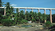
Mathur Aqueduct is a concrete structure held up by 28 huge pillars, the maximum height of the pillars reaching 115 ft. The trough structure is 7 ft in height, with a width of 7.5 ft. The trough is partly covered on top with concrete slabs, allowing people to walk on the bridge and also see the water going through the trough. Some of the pillars are set in rocks of the Pahrali river, though some of the pillars are set in hills on either side.
Road access allows one to drive in to one side of the Aqueduct (up to one end), while it is also possible to drive into the foot of the Aqueduct (the level where the Pahrali flows) on the opposite side. There is also a huge flight of stairs (made in recent times) that allows one to climb from the level of the Pahrali
Pahrali
Pahrali River flows through the Kanyakumari District in southern India. It originates in the Mahendragiri hills. The Mathur Hanging Trough, the highest and longest aqueduct in Asia, was built over it near Mathur. Perunchani dam is constructed across Pahrali river....
river to the trough.
Irrigation Water flows through the trough for a major part of the year, except in the summer (from February to May).
Tourist attraction
Kanyakumari District
Kanyakumari District ) is a district of Tamil Nadu state, India and is the southernmost land area of mainland India.The district is the second most urbanised district in Tamilnadu, next only to Chennai and ahead of Coimbatore. It also has the highest literacy and education levels in the...
. The tourism department and the local Panchyat office have improved facilities for the visiting tourists.
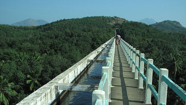
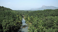
From the centre of the Aqueduct, one can see a vast expanse of greenery, with rolling hills of the Western Ghats
Western Ghats
The Western Ghats, Western Ghauts or the Sahyādri is a mountain range along the western side of India. It runs north to south along the western edge of the Deccan Plateau, and separates the plateau from a narrow coastal plain along the Arabian Sea. The Western Ghats block rainfall to the Deccan...
in the background, and the meandering Pahrali
Pahrali
Pahrali River flows through the Kanyakumari District in southern India. It originates in the Mahendragiri hills. The Mathur Hanging Trough, the highest and longest aqueduct in Asia, was built over it near Mathur. Perunchani dam is constructed across Pahrali river....
river flowing below.
Mathur Aqueduct is about 60 km from the popular tourist town of Kanyakumari and about 60 km from the city of Trivandrum, the capital of Kerala
Kerala
or Keralam is an Indian state located on the Malabar coast of south-west India. It was created on 1 November 1956 by the States Reorganisation Act by combining various Malayalam speaking regions....
state.
External links
Coordinates: 8°20'9"N 77°17'41"E