
Maryland Route 835
Encyclopedia
Maryland Route 835 is a collection of state highway
s in the U.S. state
of Maryland
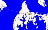
. These ten highways are service roads or old alignments in the vicinity of MD 18
and U.S. Route 50
and US 301
in western Queen Anne's County
. One of the highways, MD 835A, is signed; it is the only state highway in Maryland that is signed with its letter suffix. MD 835 and MD 835G are found in Kent Narrows
. MD 835A, MD 835C, and MD 835F are located in Stevensville
. MD 835B and MD 835H through MD 835K are in Grasonville
.

State highway
State highway, state road or state route can refer to one of three related concepts, two of them related to a state or provincial government in a country that is divided into states or provinces :#A...
s in the U.S. state
U.S. state
A U.S. state is any one of the 50 federated states of the United States of America that share sovereignty with the federal government. Because of this shared sovereignty, an American is a citizen both of the federal entity and of his or her state of domicile. Four states use the official title of...
of Maryland
Maryland
Maryland is a U.S. state located in the Mid Atlantic region of the United States, bordering Virginia, West Virginia, and the District of Columbia to its south and west; Pennsylvania to its north; and Delaware to its east...
. These ten highways are service roads or old alignments in the vicinity of MD 18
Maryland Route 18
Maryland Route 18 is a state highway in the U.S. state of Maryland. The state highway runs from the beginning of state maintenance at Love Point east to MD 213 in Centreville...
and U.S. Route 50
U.S. Route 50 in Maryland
U.S. Route 50 is a major east–west route of the U.S. Highway system, stretching just over from Ocean City, Maryland on the Atlantic Ocean to West Sacramento, California. In the U.S. state of Maryland, US 50 exists in two sections. The longer of these serves as a major route connecting...
and US 301
U.S. Route 301 in Maryland
U.S. Route 301 in Maryland is a major highway that runs from Delaware to the Governor Harry W. Nice Memorial Bridge into Virginia. It passes through three of Maryland's four main regions: the Eastern Shore, the Baltimore-Washington Metropolitan Area, and Southern Maryland...
in western Queen Anne's County
Queen Anne's County, Maryland
Queen Anne's County is a county located on the Eastern Shore of the U.S. state of Maryland.As of 2010, the population was 47,798. Its county seat and most populous municipality is Centreville. The census-designated place of Stevensville is the county's most populous place...
. One of the highways, MD 835A, is signed; it is the only state highway in Maryland that is signed with its letter suffix. MD 835 and MD 835G are found in Kent Narrows
Kent Narrows
The Kent Narrows, also known as Kent Island Narrows and to local residents simply as the Narrows, is a waterway that connects the Chester River with the Eastern Bay and also separates Kent Island from the Delmarva Peninsula. It runs through the community of Kent Narrows, Maryland. The Kent...
. MD 835A, MD 835C, and MD 835F are located in Stevensville
Stevensville, Maryland
Stevensville is a census-designated place in Queen Anne's County, Maryland, and is the county's most populous place among both CDPs and municipalities. The Stevensville Historic District is one of only two registered historic districts in the county, the other being the Centreville Historic...
. MD 835B and MD 835H through MD 835K are in Grasonville
Grasonville, Maryland
Grasonville is a census-designated place in Queen Anne's County, Maryland, United States. The population was 2,193 at the 2000 census.-Geography:Grasonville is located at ....
.
- MD 835 is the designation for Seward Marina Road, a 0.13 mile (0.2092142 km) connector between MD 18 and a right-in/right-outRight-in/right-outRight-in/right-out and left-in/left-out refer to a type of road intersection where turning movements of vehicles are restricted. A RIRO permits only right turns and a LILO permits only left turns. RIRO is usual where vehicles drive on the right, and LILO is usual where vehicles drive on the left...
interchange (Exit 42) with eastbound US 50 and US 301 on the east side of Kent Narrows.
- MD 835A is the signed designation for the state-maintained portion of Pier One Road and Thompson Creek Service Road, which together run 0.77 miles (1.2 km) along the eastbound side of US 50 and US 301 in Stevensville. MD 835A is the only state highway in Maryland signed with its letter suffix. The state highway's western terminus is at the beginning of state maintenance just west of MD 8Maryland Route 8Maryland Route 8 is a state highway in the U.S. state of Maryland. Known for most of its length as Romancoke Road, the state highway runs from Romancoke Pier in Romancoke north to MD 18 in Stevensville. MD 8 is the main north–south highway of Kent Island in western Queen Anne's County. ...
(Romancoke Road), a short distance south of MD 8's interchange with US 50 and US 301, east of the Bay Bridge Marina, and north of Bay Bridge AirportBay Bridge AirportBay Bridge Airport is a county-owned public-use airport located in Stevensville, Maryland. The airport is named for the nearby Chesapeake Bay Bridge and is mostly used for general aviation....
. After the intersection with MD 8, MD 835A curves to the northeast and closely parallels the freeway, providing access to a park and ridePark and ridePark and ride facilities are car parks with connections to public transport that allow commuters and other people wishing to travel into city centres to leave their vehicles and transfer to a bus, rail system , or carpool for the rest of their trip...
facility and a pair of shopping centers. The state highway reaches its eastern terminus at a roundabout with Thompson Creek Road and the right-in/right-out ramps of Exit 38A of US 50 and US 301.
- MD 835B is the designation for Saddler Road, a 0.62 mile (0.9977908 km) highway that parallels the westbound side of US 50 and US 301 between Jackson Creek Road and Chester River Beach Road (unsigned MD 18V) in Grasonville.
- MD 835C is the designation for the old alignment of MD 18 through the Stevensville Historic DistrictStevensville Historic DistrictThe Stevensville Historic District, also known as Historic Stevensville, is a national historic district in downtown Stevensville, Queen Anne's County, Maryland. It contains roughly 100 historic structures, and is listed on the National Register of Historic Places...
. The 0.77 miles (1.2 km) highway follows Old Love Point Road and East Main Street between intersections with MD 18 in Stevensville and passes by Christ Church.
- MD 835F is the designation for a 0.05 mile (0.080467 km) section of Schooner Parkway west from MD 18 in Stevensville. The state highway provides access to an office park.
- MD 835G is the designation for Kent Narrows Road, a 0.4 mile (0.643736 km) connector between Kent Narrows Way North immediately east of Kent Narrows and a right-in/right-out interchange (Exit 42) with westbound US 50 and US 301.
- MD 835H is the designation for a 0.74 miles (1.2 km) stretch of Winchester Creek Road that parallels the westbound side of US 50 and US 301 between VFW Avenue (MD 18W) and Hissey Road (MD 835I) in Grasonville. MD 835H features a right-in/right-out interchange (Exit 44B) with the westbound freeway.
- MD 835I is the designation for a 0.2 mile (0.321868 km) segment of Hissey Road from a right-in/right-out interchange (Exit 45A) with westbound US 50 and US 301 to just north of the highway's intersection with MD 835H in Grasonville.
- MD 835J is the designation for a 0.77 miles (1.2 km) stretch of Winchester Creek Road and Blackbeard Road that parallels the westbound side of US 50 and US 301 between Hissey Road (MD 835I) and the end of state maintenance east of Nesbit Road (MD 835K) and the westbound ramps for Exit 45B in Grasonville.
- MD 835K is the designation for a 0.42 mile (0.6759228 km) portion of Nesbit Road between MD 18 and a point just north of MD 835J in Grasonville.