
Maryland Route 528
Encyclopedia
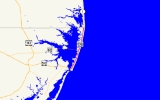
Maryland Route 528 is a state highway
in the U.S. state
of Maryland
. Known for most of its length as Coastal Highway, the state highway runs 9.04 miles (14.5 km) from the southern terminus of its companion route, unsigned
Maryland Route 378, in downtown Ocean City
north to the Delaware
state line at the northern edge of the resort town, where the state highway continues as Delaware Route 1 (DE 1). In downtown Ocean City, MD 378 and MD 528 form a one-way pair
, with MD 378 following Baltimore Avenue northbound and MD 528 following Philadelphia Avenue northbound. The two state highways meet the eastern terminus of U.S. Route 50
(US 50) in the downtown area. North of downtown, MD 528 is Coastal Highway, a six-lane divided highway that forms the transportation backbone of the resort town, providing access to the eastern terminus of MD 90
, the southern terminus of DE 1, and the eastern terminus of DE 54. As the main access highway to countless hotels, condos, restaurants, shops, and other businesses catering to tourists, MD 528 and MD 378 see heavy seasonal traffic. Due to their importance as the resort's sole conduits and providing access to evacuation routes
, MD 528 and MD 378 are parts of the National Highway System
between US 50 and the Delaware state line.
Both Baltimore Avenue and Philadelphia Avenue date back to the founding of Ocean City in the late 19th century. MD 378 was assigned to Baltimore Avenue in 1927, while MD 528 was assigned to Philadelphia Avenue in 1933. MD 528 was extended north of 15th Street to the Delaware state line in 1939. Both highways were rebuilt and widened in the 1950s. MD 528 was expanded to a six-lane divided highway north of the one-way pair in the late 1980s.
MD 528 and MD 378 head north through the downtown area of Ocean City, where they meet the eastern terminus of US 50 at North Division Street. North Division Street between MD 528 and MD 378 is one-way eastbound, so traffic coming from the south uses North 1st Street, which is one-way westbound and designated MD 378A, to access US 50 west. MD 528 and MD 378 continue north to 9th Street, which is one-way westbound and designated MD 378B. MD 528 becomes two-way at 9th Street. MD 378 continues north as a two-lane street northbound to 15th Street, where the state highway turns left to reach its northern terminus at MD 528. Baltimore Avenue continues north of 15th Street as a two-way municipal street to its northern end at 33rd Street.
MD 528 heads north from 9th Street as Philadelphia Avenue, a divided highway with two lanes northbound and three lanes southbound. The state highway gains a third lane northbound at MD 378 (15th Street). At 17th Street, MD 528 assumes its form for the remainder of its course to the Delaware state line: three lanes in each direction plus continuous right turn and bus lanes. After passing the Jolly Roger Amusement Park, MD 528 meets 33rd Street, which is one-way westbound coming from the northern end of Baltimore Avenue. North of 33rd Street, MD 528 becomes Coastal Highway, the only through highway on the barrier island. The state highway passes the Ocean City Convention Center
at 40th Street and intersects the eastern terminus of MD 90 (Ocean City Expressway) at 62nd Street. MD 528 continues north until it reaches the Delaware state line at 146th Street. Coastal Highway continues into Fenwick Island
as DE 1, which meets the eastern terminus of DE 54 one block north of the state line.
Traffic in Ocean City had increased so much there was a movement to make Baltimore and Philadelphia Avenues one-way in the downtown area, a change that was implemented by 1948. Traffic volume in Ocean City increased even more following the completion of the Chesapeake Bay Bridge
in 1952, leading to expansion of the city's north–south arterials. MD 378 was widened along its entire length in 1951 and 1952. MD 528 was widened to four lanes along its entire length in 1953 and 1954. Both state highways were extended to their present southern termini at that time. The first portion of MD 528 to be expanded to a divided highway was around the intersection with MD 90; the highway between 60th and 63rd Streets was reconstructed by 1978. Two sections of six-lane divided highway were completed around 1989: from 25th Street to 65th Street, and from 85th Street to 122nd Street. By 1991, MD 528 was divided highway from 25th Street to the Delaware state line. The segment of Philadelphia Avenue from 9th Street to 25th Street was changed from a five- to six-lane highway with a center turn lane to a divided highway in 2001.
, Worcester County
.
State highway
State highway, state road or state route can refer to one of three related concepts, two of them related to a state or provincial government in a country that is divided into states or provinces :#A...
in the U.S. state
U.S. state
A U.S. state is any one of the 50 federated states of the United States of America that share sovereignty with the federal government. Because of this shared sovereignty, an American is a citizen both of the federal entity and of his or her state of domicile. Four states use the official title of...
of Maryland
Maryland
Maryland is a U.S. state located in the Mid Atlantic region of the United States, bordering Virginia, West Virginia, and the District of Columbia to its south and west; Pennsylvania to its north; and Delaware to its east...
. Known for most of its length as Coastal Highway, the state highway runs 9.04 miles (14.5 km) from the southern terminus of its companion route, unsigned
Unsigned highway
An unsigned highway is a highway that has been assigned a route number, but does not bear conventional road markings that would normally be used to identify the route with that number...
Maryland Route 378, in downtown Ocean City
Ocean City, Maryland
Ocean City, sometimes known as OC, or OCMD, is an Atlantic Ocean resort town in Worcester County, Maryland, United States. Ocean City is widely known in the Mid-Atlantic region of the United States and is a frequent destination for vacationers in that area...
north to the Delaware
Delaware
Delaware is a U.S. state located on the Atlantic Coast in the Mid-Atlantic region of the United States. It is bordered to the south and west by Maryland, and to the north by Pennsylvania...
state line at the northern edge of the resort town, where the state highway continues as Delaware Route 1 (DE 1). In downtown Ocean City, MD 378 and MD 528 form a one-way pair
One-way pair
A one-way pair, one-way couple, or just couplet is a pair of parallel, usually one-way streets that carry opposite directions of a signed route or major traffic flow, or sometimes opposite directions of a bus or streetcar route....
, with MD 378 following Baltimore Avenue northbound and MD 528 following Philadelphia Avenue northbound. The two state highways meet the eastern terminus of U.S. Route 50
U.S. Route 50 in Maryland
U.S. Route 50 is a major east–west route of the U.S. Highway system, stretching just over from Ocean City, Maryland on the Atlantic Ocean to West Sacramento, California. In the U.S. state of Maryland, US 50 exists in two sections. The longer of these serves as a major route connecting...
(US 50) in the downtown area. North of downtown, MD 528 is Coastal Highway, a six-lane divided highway that forms the transportation backbone of the resort town, providing access to the eastern terminus of MD 90
Maryland Route 90
Maryland Route 90 is a state highway in the U.S. state of Maryland. Known as the Ocean City Expressway, the state highway runs from U.S. Route 50 near Whaleyville to MD 528 in Ocean City. MD 90 is a two-lane expressway that provides one of the main access routes to Ocean City, especially the...
, the southern terminus of DE 1, and the eastern terminus of DE 54. As the main access highway to countless hotels, condos, restaurants, shops, and other businesses catering to tourists, MD 528 and MD 378 see heavy seasonal traffic. Due to their importance as the resort's sole conduits and providing access to evacuation routes
Hurricane evacuation route
A hurricane evacuation route is a highway in the United States that is a specified route for hurricane evacuation.Along the Gulf Coast, hurricane evacuation routes lead north and west for up to hundreds of miles to the safest major city. Along the Atlantic Coast, routes lead west. They are marked...
, MD 528 and MD 378 are parts of the National Highway System
National Highway System (United States)
The National Highway System is a network of strategic highways within the United States, including the Interstate Highway System and other roads serving major airports, ports, rail or truck terminals, railway stations, pipeline terminals and other strategic transport facilities.Individual states...
between US 50 and the Delaware state line.
Both Baltimore Avenue and Philadelphia Avenue date back to the founding of Ocean City in the late 19th century. MD 378 was assigned to Baltimore Avenue in 1927, while MD 528 was assigned to Philadelphia Avenue in 1933. MD 528 was extended north of 15th Street to the Delaware state line in 1939. Both highways were rebuilt and widened in the 1950s. MD 528 was expanded to a six-lane divided highway north of the one-way pair in the late 1980s.
Route description
MD 528 and MD 378 both have their southern termini at the intersection of Baltimore Avenue and South 1st Street at the southern end of Ocean City. Baltimore Avenue continues south and then turns east toward a large municipal parking lot serving attractions on the Ocean City Boardwalk, including Trimper's Rides. From the southern terminus, MD 528 heads west on South 1st Street and then north as Philadelphia Avenue, while MD 378 heads north as Baltimore Avenue. The two state highways form a one-way pair, with MD 378 carrying three lanes of northbound traffic and MD 528 carrying three lanes of southbound traffic. Both streets intersect South Division Street, which was formerly the site of the railroad terminus in Ocean City and currently the site of Sunset Park, and Worcester Street, which was formerly the site of the first automobile bridge to the resort in 1916.MD 528 and MD 378 head north through the downtown area of Ocean City, where they meet the eastern terminus of US 50 at North Division Street. North Division Street between MD 528 and MD 378 is one-way eastbound, so traffic coming from the south uses North 1st Street, which is one-way westbound and designated MD 378A, to access US 50 west. MD 528 and MD 378 continue north to 9th Street, which is one-way westbound and designated MD 378B. MD 528 becomes two-way at 9th Street. MD 378 continues north as a two-lane street northbound to 15th Street, where the state highway turns left to reach its northern terminus at MD 528. Baltimore Avenue continues north of 15th Street as a two-way municipal street to its northern end at 33rd Street.
MD 528 heads north from 9th Street as Philadelphia Avenue, a divided highway with two lanes northbound and three lanes southbound. The state highway gains a third lane northbound at MD 378 (15th Street). At 17th Street, MD 528 assumes its form for the remainder of its course to the Delaware state line: three lanes in each direction plus continuous right turn and bus lanes. After passing the Jolly Roger Amusement Park, MD 528 meets 33rd Street, which is one-way westbound coming from the northern end of Baltimore Avenue. North of 33rd Street, MD 528 becomes Coastal Highway, the only through highway on the barrier island. The state highway passes the Ocean City Convention Center
Ocean City Convention Center
The Roland E. Powell Convention Center, also known as the Ocean City Convention Center, is a multi-purpose convention center in Ocean City, Maryland, USA. It contains of floor space. It can also be converted into a 5,000 seat indoor arena that can host sporting events, like wrestling, as well as...
at 40th Street and intersects the eastern terminus of MD 90 (Ocean City Expressway) at 62nd Street. MD 528 continues north until it reaches the Delaware state line at 146th Street. Coastal Highway continues into Fenwick Island
Fenwick Island, Delaware
As of the census of 2000, there were 342 people, 178 households, and 126 families residing in the town. The population density was 994.5 people per square mile . There were 666 housing units at an average density of 1,936.7 per square mile . The racial makeup of the town was 99.42% White, and 0.58%...
as DE 1, which meets the eastern terminus of DE 54 one block north of the state line.
History
Baltimore Avenue and Philadelphia Avenue date back to the founding of Ocean City in 1875. Both avenues originally extended from South Division Street to North Division Street. The streets were later extended north as far as 15th Street. Baltimore Avenue served as the main thoroughfare of Ocean City until Philadelphia Avenue and Coastal Highway assumed predominance in the 1950s. As a result, MD 378 was assigned to Baltimore Avenue, which was paved from US 213 (Worcester Street) to 15th Street by 1927. MD 528 was assigned to Philadelphia Avenue when that street was rebuilt between US 213 and 15th Street in 1933. MD 528 was extended north to the Delaware state line when Coastal Highway was completed in 1939.Traffic in Ocean City had increased so much there was a movement to make Baltimore and Philadelphia Avenues one-way in the downtown area, a change that was implemented by 1948. Traffic volume in Ocean City increased even more following the completion of the Chesapeake Bay Bridge
Chesapeake Bay Bridge
The Chesapeake Bay Bridge is a major dual-span bridge in the U.S. state of Maryland. Spanning the Chesapeake Bay, it connects the state's rural Eastern Shore region with the more urban Western Shore. The original span opened in 1952 and, at the time, with a length of , it was the world's longest...
in 1952, leading to expansion of the city's north–south arterials. MD 378 was widened along its entire length in 1951 and 1952. MD 528 was widened to four lanes along its entire length in 1953 and 1954. Both state highways were extended to their present southern termini at that time. The first portion of MD 528 to be expanded to a divided highway was around the intersection with MD 90; the highway between 60th and 63rd Streets was reconstructed by 1978. Two sections of six-lane divided highway were completed around 1989: from 25th Street to 65th Street, and from 85th Street to 122nd Street. By 1991, MD 528 was divided highway from 25th Street to the Delaware state line. The segment of Philadelphia Avenue from 9th Street to 25th Street was changed from a five- to six-lane highway with a center turn lane to a divided highway in 2001.
Junction list
The entire route is in Ocean CityOcean City, Maryland
Ocean City, sometimes known as OC, or OCMD, is an Atlantic Ocean resort town in Worcester County, Maryland, United States. Ocean City is widely known in the Mid-Atlantic region of the United States and is a frequent destination for vacationers in that area...
, Worcester County
Worcester County, Maryland
-2010:Whereas according to the 2010 U.S. Census Bureau:*82.0% White*13.6% Black*0.3% Native American*1.1% Asian*0.0% Native Hawaiian or Pacific Islander*1.7% Two or more races*1.3% Other races*3.2% Hispanic or Latino -2000:...
.
| Mile |
Destinations | Notes |
|---|---|---|
| 0.00 | Baltimore Avenue south – Ocean City Boardwalk | Southern terminus of one-way pair formed by MD 528 (southbound) on Philadelphia Avenue and unsigned MD 378 (northbound) on Baltimore Avenue |
| Worcester Avenue | Original alignment of former US 213 | |
| 1st Street | Portion of 1st Street east of MD 528 is unsigned MD 378A; one-way street westbound | |
| 9th Street | MD 528 becomes two-way at this intersection; portion of 9th Street east of MD 528 is unsigned MD 378B; one-way street westbound | |
| Northern terminus of MD 378; MD 378 is one-way street westbound | ||
| 33rd Street | 33rd Street is one-way westbound on east side of intersection | |
| 94th Street | ||
| 9.04 | 146th Street | Northern terminus of MD 528; Delaware state line |
| – Fenwick Island, DE Fenwick Island, Delaware As of the census of 2000, there were 342 people, 178 households, and 126 families residing in the town. The population density was 994.5 people per square mile . There were 666 housing units at an average density of 1,936.7 per square mile . The racial makeup of the town was 99.42% White, and 0.58%... , Rehoboth Beach, DE Rehoboth Beach, Delaware Rehoboth Beach is a city in Sussex County, Delaware, United States. According to the 2010 census, the population is 1,327, a decrease of 11.2% from 2000... , Selbyville, DE Selbyville, Delaware As of the census of 2000, there were 1,645 people, 615 households, and 439 families residing in the town. The population density was 1,176.9 people per square mile . There were 664 housing units at an average density of 475.1 per square mile... |
MD 378
MD 378 is the unsigned designation for Baltimore Avenue and 15th Street, a 1.49 miles (2.4 km) highway that runs from the southern terminus of MD 528 at the southern end of Ocean City north to MD 528 north of the downtown area of Ocean City. As MD 378 is effectively the northbound direction of MD 528 in downtown Ocean City, the state highway is covered in more detail in the main sections of this article. MD 378 has two auxiliary routes:- MD 378A is the designation for 1st Street, a 0.07 mile (0.1126538 km) connector between MD 378 and MD 528 just north of US 50 in Ocean City. The state highway is one-way westbound, helping provide access to US 50 from traffic at the southern end of the barrier island.
- MD 378B is the designation for 9th Street, a 0.07 mile (0.1126538 km) connector between MD 378 and MD 528 on the northern edge of downtown Ocean City. MD 378B, which is one-way westbound, serves as the main conduit for MD 378 traffic headed for the central and northern parts of Ocean City along MD 528, connecting with MD 528 at the point the highway becomes two-way. For that reason, MD 378B is part of the National Highway System.