
Maryland Route 408
Encyclopedia
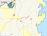
Maryland Route 408, known locally as Mt Zion - Marlboro Road, is an east–west highway in Anne Arundel County, Maryland
. This route heads east from its interchange with Southern Maryland Boulevard
to its terminus with Solomons Island Road
and Bayard Rd
at the Lothian Roundabout
. It is a former designation of Maryland Route 4
.
in Waysons Corner. This interchange is a diamond interchange, with MD 408 passing over MD 4. Access to MD 408 from northbound MD 4 is provided through an offramp onto Maryland Route 794
, a parallel route to MD 4. Heading east, MD 408 passes through its signalized intersection with MD 794
, heads towards its intersection with Sands Rd and continues out of Waysons Corner as a two lane road.
Out of Waysons Corner, MD 408 runs through a principally rural area of Anne Arundel County
along a slightly curvy alignment. Past its intersection with Greenock Rd
, MD 408 travels northeast towards Lothian
. In Lothian, MD 408 terminates at the Lothian Roundabout, an intersection of MD 2
, MD 422
, and MD 408.
Maryland
Maryland is a U.S. state located in the Mid Atlantic region of the United States, bordering Virginia, West Virginia, and the District of Columbia to its south and west; Pennsylvania to its north; and Delaware to its east...
. This route heads east from its interchange with Southern Maryland Boulevard
Maryland Route 4
Maryland Route 4 is a state highway in the U.S. state of Maryland. The state highway runs from MD 5 in Leonardtown north to Southern Avenue at the Washington, D.C. border, past which the highway continues as Pennsylvania Avenue...
to its terminus with Solomons Island Road
Maryland Route 2
Maryland Route 2 is the longest state highway in the U.S. state of Maryland. The route runs from Solomons Island in Calvert County north to an intersection with U.S. Route 1 and U.S. Route 40 Truck in Baltimore...
and Bayard Rd
Maryland Route 422
Maryland Route 422 is a state highway in the U.S. state of Maryland. Known as Bayard Road, the route runs from Polling House Road near Bayard east to Maryland Route 2 in Lothian.-Route description:...
at the Lothian Roundabout
Lothian, Maryland
Lothian is an unincorporated community in Anne Arundel County, Maryland, United States.Lothian is a rural community in southern , Maryland, 12 miles southwest of Annapolis, Maryland, 24 miles east of Washington, DC, and 31 miles south of Baltimore, Maryland....
. It is a former designation of Maryland Route 4
Maryland Route 4
Maryland Route 4 is a state highway in the U.S. state of Maryland. The state highway runs from MD 5 in Leonardtown north to Southern Avenue at the Washington, D.C. border, past which the highway continues as Pennsylvania Avenue...
.
Route description
MD Route 408 begins at an interchange with Maryland Route 4Maryland Route 4
Maryland Route 4 is a state highway in the U.S. state of Maryland. The state highway runs from MD 5 in Leonardtown north to Southern Avenue at the Washington, D.C. border, past which the highway continues as Pennsylvania Avenue...
in Waysons Corner. This interchange is a diamond interchange, with MD 408 passing over MD 4. Access to MD 408 from northbound MD 4 is provided through an offramp onto Maryland Route 794
Maryland Route 794
Maryland Route 794 is a state highway in the U.S. state of Maryland. Known as Southern Maryland Boulevard, the state highway runs from MD 4 in Bristol north to MD 408 at Waysons Corner in southwestern Anne Arundel County. MD 794 is the old alignment of MD 4.-Route description:MD 794 begins as...
, a parallel route to MD 4. Heading east, MD 408 passes through its signalized intersection with MD 794
Maryland Route 794
Maryland Route 794 is a state highway in the U.S. state of Maryland. Known as Southern Maryland Boulevard, the state highway runs from MD 4 in Bristol north to MD 408 at Waysons Corner in southwestern Anne Arundel County. MD 794 is the old alignment of MD 4.-Route description:MD 794 begins as...
, heads towards its intersection with Sands Rd and continues out of Waysons Corner as a two lane road.
Out of Waysons Corner, MD 408 runs through a principally rural area of Anne Arundel County
Anne Arundel County, Maryland
Anne Arundel County is a county located in the U.S. state of Maryland. It is named for Anne Arundell , a member of the ancient family of Arundells in Cornwall, England and the wife of Cæcilius Calvert, 2nd Baron Baltimore. Its county seat is Annapolis, which is also the capital of the state...
along a slightly curvy alignment. Past its intersection with Greenock Rd
Maryland Route 259
Maryland Route 259 is a state highway in the U.S. state of Maryland. Known as Greenock Road, the route runs from Maryland Route 794 in Bristol north to Maryland Route 408 near Lothian.-Route description:...
, MD 408 travels northeast towards Lothian
Lothian, Maryland
Lothian is an unincorporated community in Anne Arundel County, Maryland, United States.Lothian is a rural community in southern , Maryland, 12 miles southwest of Annapolis, Maryland, 24 miles east of Washington, DC, and 31 miles south of Baltimore, Maryland....
. In Lothian, MD 408 terminates at the Lothian Roundabout, an intersection of MD 2
Maryland Route 2
Maryland Route 2 is the longest state highway in the U.S. state of Maryland. The route runs from Solomons Island in Calvert County north to an intersection with U.S. Route 1 and U.S. Route 40 Truck in Baltimore...
, MD 422
Maryland Route 422
Maryland Route 422 is a state highway in the U.S. state of Maryland. Known as Bayard Road, the route runs from Polling House Road near Bayard east to Maryland Route 2 in Lothian.-Route description:...
, and MD 408.
Junction list
| County | Location | Mile | Intersection | Notes |
|---|---|---|---|---|
| Anne Arundel (5.62 mi) |
Waysons Corner | 0.00 |  MD 4 MD 4Maryland Route 4 Maryland Route 4 is a state highway in the U.S. state of Maryland. The state highway runs from MD 5 in Leonardtown north to Southern Avenue at the Washington, D.C. border, past which the highway continues as Pennsylvania Avenue... (Southern Maryland Boulevard) |
To Upper Marlboro Upper Marlboro, Maryland Upper Marlboro is a town in and the county seat of Prince George's County, Maryland, United States. The live-in population of the town core proper was only 648 at the 2000 census, although Greater Upper Marlboro is many times larger.... / Dunkirk Dunkirk, Maryland Dunkirk is a census-designated place in Calvert County, Maryland, United States. The population was 2,363 at the 2000 census. The area is very fast-growing, with many large estate homes. Considered one the wealthiest places to live inside the Washington, DC metropolitan area, with home prices... |
| 0.15 |  MD 794 MD 794Maryland Route 794 Maryland Route 794 is a state highway in the U.S. state of Maryland. Known as Southern Maryland Boulevard, the state highway runs from MD 4 in Bristol north to MD 408 at Waysons Corner in southwestern Anne Arundel County. MD 794 is the old alignment of MD 4.-Route description:MD 794 begins as... (Southern Maryland Boulevard) |
|||
| 4.19 |  MD 259 MD 259Maryland Route 259 Maryland Route 259 is a state highway in the U.S. state of Maryland. Known as Greenock Road, the route runs from Maryland Route 794 in Bristol north to Maryland Route 408 near Lothian.-Route description:... (Greenock Rd) |
|||
| Lothian Lothian, Maryland Lothian is an unincorporated community in Anne Arundel County, Maryland, United States.Lothian is a rural community in southern , Maryland, 12 miles southwest of Annapolis, Maryland, 24 miles east of Washington, DC, and 31 miles south of Baltimore, Maryland.... |
5.62 |  MD 2 MD 2Maryland Route 2 Maryland Route 2 is the longest state highway in the U.S. state of Maryland. The route runs from Solomons Island in Calvert County north to an intersection with U.S. Route 1 and U.S. Route 40 Truck in Baltimore... (Solomons Island Rd) |
Lothian Roundabout | |
| 5.62 |  MD 422 MD 422Maryland Route 422 Maryland Route 422 is a state highway in the U.S. state of Maryland. Known as Bayard Road, the route runs from Polling House Road near Bayard east to Maryland Route 2 in Lothian.-Route description:... (Bayard Rd) |
|||
 Mt Zion - Marlboro Rd ends at the Lothian Roundabout Mt Zion - Marlboro Rd ends at the Lothian Roundabout |
||||