
Maryland Route 364
Encyclopedia
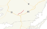
Maryland Route 364 is a state highway
in the U.S. state
of Maryland
. Known as Dividing Creek Road, the state highway runs 5.43 miles (8.7 km) from U.S. Route 13
(US 13) in West Pocomoke
north to Pocomoke State Forest. MD 364 parallels the Pocomoke River
and provides access to Pocomoke River State Park
. The state highway was mostly constructed in the early 1930s.
. MD 364 heads north as a two-lane road, passing both ends of Pocomoke River Road. After intersecting Courthouse Hill Road, the state highway crosses Dividing Creek
and enters Worcester County
. MD 364 passes through more farmland, then reaches its northern terminus just beyond Cellar House Road on the edge of Pocomoke State Forest. The highway continues as Nassawango Road, a county highway that passes through the state forest and provides access to the Milburn Landing unit of Pocomoke River State Park.
!County
!Location
!Mile
!Destinations
!Notes
|-
|rowspan=4|Somerset
|rowspan=4|West Pocomoke
|rowspan=2|0.00
|
|rowspan=2|Southern terminus
|-
|, Norfolk
|-
|0.09
|Pocomoke River Road
|rowspan=2|Former MD 580
|-
|0.84
|Pocomoke River Road
|-
|Worcester
|Pocomoke State Forest
|5.43
|Nassawango Road north – Pocomoke River State Park
|Northern terminus
State highway
State highway, state road or state route can refer to one of three related concepts, two of them related to a state or provincial government in a country that is divided into states or provinces :#A...
in the U.S. state
U.S. state
A U.S. state is any one of the 50 federated states of the United States of America that share sovereignty with the federal government. Because of this shared sovereignty, an American is a citizen both of the federal entity and of his or her state of domicile. Four states use the official title of...
of Maryland
Maryland
Maryland is a U.S. state located in the Mid Atlantic region of the United States, bordering Virginia, West Virginia, and the District of Columbia to its south and west; Pennsylvania to its north; and Delaware to its east...
. Known as Dividing Creek Road, the state highway runs 5.43 miles (8.7 km) from U.S. Route 13
U.S. Route 13 in Maryland
U.S. Route 13 is a U.S. Highway running from Fayetteville, North Carolina north to Morrisville, Pennsylvania. In the U.S. state of Maryland, the route runs from the Virginia border south of Pocomoke City in Worcester County north to the Delaware border in Delmar, Wicomico County, where the route...
(US 13) in West Pocomoke
West Pocomoke, Maryland
West Pocomoke is a census-designated place in Somerset County, Maryland, United States. The population was 498 at the 2000 census. It is included in the Salisbury, Maryland Metropolitan Statistical Area.-Geography:...
north to Pocomoke State Forest. MD 364 parallels the Pocomoke River
Pocomoke River
The Pocomoke River stretches approximately from southern Delaware through southeastern Maryland in the United States. At its mouth, the river is essentially an arm of Chesapeake Bay, whereas the upper river flows through a series of relatively inaccessible wetlands called the Great Cypress Swamp,...
and provides access to Pocomoke River State Park
Pocomoke River State Park
Pocomoke River State Park is a state park of Maryland that lies on both banks of the Pocomoke River in Worcester County, located adjacent to the Pocomoke State Forest....
. The state highway was mostly constructed in the early 1930s.
Route description
MD 364 begins at an intersection with US 13 (Ocean Highway) in West Pocomoke. The highway continues on the other side of the intersection as US 13 Business toward Pocomoke CityPocomoke City, Maryland
Pocomoke City, dubbed "the friendliest town on the Eastern Shore", is a city in Worcester County, Maryland, United States. Although renamed in a burst of civic enthusiasm in 1878, the city is regularly referred to by its inhabitants simply as Pocomoke...
. MD 364 heads north as a two-lane road, passing both ends of Pocomoke River Road. After intersecting Courthouse Hill Road, the state highway crosses Dividing Creek
Dividing Creek (Maryland)
Dividing Creek is a tributary of the Pocomoke River on the Delmarva Peninsula. It rises in Wicomico County, Maryland, and forms the boundary between Somerset and Worcester counties....
and enters Worcester County
Worcester County, Maryland
-2010:Whereas according to the 2010 U.S. Census Bureau:*82.0% White*13.6% Black*0.3% Native American*1.1% Asian*0.0% Native Hawaiian or Pacific Islander*1.7% Two or more races*1.3% Other races*3.2% Hispanic or Latino -2000:...
. MD 364 passes through more farmland, then reaches its northern terminus just beyond Cellar House Road on the edge of Pocomoke State Forest. The highway continues as Nassawango Road, a county highway that passes through the state forest and provides access to the Milburn Landing unit of Pocomoke River State Park.
History
The first part of MD 364 to be paved was a segment north of Dividing Creek, which was built as a state aid road between 1912 and 1915. By 1927, another segment was built from US 13 halfway to Dividing Creek. The state aid road was partially reconstructed and the remainder of the highway was under construction by 1933, with MD 364 completed in 1935.Junction list
{| class=wikitable!County
!Location
!Mile
!Destinations
!Notes
|-
|rowspan=4|Somerset
Somerset County, Maryland
-2010:Whereas according to the 2010 U.S. Census Bureau:*53.5% White*42.3% Black*0.3% Native American*0.7% Asian*0.0% Native Hawaiian or Pacific Islander*1.7% Two or more races*1.5% Other races*3.3% Hispanic or Latino -2000:...
|rowspan=4|West Pocomoke
West Pocomoke, Maryland
West Pocomoke is a census-designated place in Somerset County, Maryland, United States. The population was 498 at the 2000 census. It is included in the Salisbury, Maryland Metropolitan Statistical Area.-Geography:...
|rowspan=2|0.00
|
|rowspan=2|Southern terminus
|-
|, Norfolk
Norfolk, Virginia
Norfolk is an independent city in the Commonwealth of Virginia in the United States. With a population of 242,803 as of the 2010 Census, it is Virginia's second-largest city behind neighboring Virginia Beach....
|-
|0.09
|Pocomoke River Road
|rowspan=2|Former MD 580
|-
|0.84
|Pocomoke River Road
|-
|Worcester
Worcester County, Maryland
-2010:Whereas according to the 2010 U.S. Census Bureau:*82.0% White*13.6% Black*0.3% Native American*1.1% Asian*0.0% Native Hawaiian or Pacific Islander*1.7% Two or more races*1.3% Other races*3.2% Hispanic or Latino -2000:...
|Pocomoke State Forest
|5.43
|Nassawango Road north – Pocomoke River State Park
Pocomoke River State Park
Pocomoke River State Park is a state park of Maryland that lies on both banks of the Pocomoke River in Worcester County, located adjacent to the Pocomoke State Forest....
|Northern terminus