
Maryland Route 359
Encyclopedia
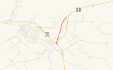
Maryland Route 359 is a state highway
in the U.S. state
of Maryland
. Known as Bypass Road, the state highway runs 1.09 miles (1.8 km) from a dead end adjacent to the junction of U.S. Route 13
and US 113
north to MD 756
within Pocomoke City
. What is now MD 359 and unsigned
MD 250A was part of a bypass of the center of Pocomoke City for the southernmost part of US 113 that was constructed in the mid 1930s. US 113 originally followed MD 756 to its southern terminus at what is now US 13 Business. The bypass was itself bypassed in the 1970s when US 113 was expanded to a four-lane divided highway to end at US 13.
. The state highway heads north as a two-lane road and meets American Legion Drive (unsigned MD 359B), which provides access to US 113. MD 359 continues north through a mix of residences and farms, meeting Carter Road, Byrd Road, and Groton Road at a five-way intersection. The state highway reaches its northern terminus at an oblique intersection with MD 756 (Old Snow Hill Road).
in Worcester County
.
{| class=wikitable
!Mile
!Destinations
!Notes
|-
|0.00
|Cul-de-sac at American Legion
|Southern terminus
|-
|0.14
|American Legion Drive north to , Norfolk
|Unsigned MD 359B
|-
|1.09
|
|Northern terminus
State highway
State highway, state road or state route can refer to one of three related concepts, two of them related to a state or provincial government in a country that is divided into states or provinces :#A...
in the U.S. state
U.S. state
A U.S. state is any one of the 50 federated states of the United States of America that share sovereignty with the federal government. Because of this shared sovereignty, an American is a citizen both of the federal entity and of his or her state of domicile. Four states use the official title of...
of Maryland
Maryland
Maryland is a U.S. state located in the Mid Atlantic region of the United States, bordering Virginia, West Virginia, and the District of Columbia to its south and west; Pennsylvania to its north; and Delaware to its east...
. Known as Bypass Road, the state highway runs 1.09 miles (1.8 km) from a dead end adjacent to the junction of U.S. Route 13
U.S. Route 13 in Maryland
U.S. Route 13 is a U.S. Highway running from Fayetteville, North Carolina north to Morrisville, Pennsylvania. In the U.S. state of Maryland, the route runs from the Virginia border south of Pocomoke City in Worcester County north to the Delaware border in Delmar, Wicomico County, where the route...
and US 113
U.S. Route 113
U.S. Route 113 is a spur of US 13 in the U.S. states of Maryland and Delaware. The U.S. Highway runs from US 13 in Pocomoke City, Maryland north to Delaware Route 1 in Milford, Delaware...
north to MD 756
Maryland Route 756
Maryland Route 756 is a state highway in the U.S. state of Maryland. Known as Old Snow Hill Road, the state highway runs from U.S. Route 13 east to US 113 within Pocomoke City. MD 756 is the original alignment of US 113 in Pocomoke City...
within Pocomoke City
Pocomoke City, Maryland
Pocomoke City, dubbed "the friendliest town on the Eastern Shore", is a city in Worcester County, Maryland, United States. Although renamed in a burst of civic enthusiasm in 1878, the city is regularly referred to by its inhabitants simply as Pocomoke...
. What is now MD 359 and unsigned
Unsigned highway
An unsigned highway is a highway that has been assigned a route number, but does not bear conventional road markings that would normally be used to identify the route with that number...
MD 250A was part of a bypass of the center of Pocomoke City for the southernmost part of US 113 that was constructed in the mid 1930s. US 113 originally followed MD 756 to its southern terminus at what is now US 13 Business. The bypass was itself bypassed in the 1970s when US 113 was expanded to a four-lane divided highway to end at US 13.
Route description
MD 359 begins at a dead end adjacent to Worcester Post 93 of the American LegionAmerican Legion
The American Legion is a mutual-aid organization of veterans of the United States armed forces chartered by the United States Congress. It was founded to benefit those veterans who served during a wartime period as defined by Congress...
. The state highway heads north as a two-lane road and meets American Legion Drive (unsigned MD 359B), which provides access to US 113. MD 359 continues north through a mix of residences and farms, meeting Carter Road, Byrd Road, and Groton Road at a five-way intersection. The state highway reaches its northern terminus at an oblique intersection with MD 756 (Old Snow Hill Road).
History
US 113 presently follows its third alignment in Pocomoke City. The first alignment, to which US 113 was assigned in 1927, began at US 13 (now US 13 Business) within the city limits, following Sixth Street and Linden Avenue to the western end of what is now MD 756. US 113 then followed MD 756 to its present intersection with US 113. The second alignment is followed by present day MD 250A and MD 359 between US 13 (now US 13 Business) and MD 756, and MD 359A north of MD 756. This bypass was completed in 1936. The present US 113 four-lane divided highway was constructed in 1974, cutting off the second alignment's direct access to US 13, which had moved to its own four-lane divided bypass of Pocomoke City in 1963.Junction list
The entire route is in Pocomoke CityPocomoke City, Maryland
Pocomoke City, dubbed "the friendliest town on the Eastern Shore", is a city in Worcester County, Maryland, United States. Although renamed in a burst of civic enthusiasm in 1878, the city is regularly referred to by its inhabitants simply as Pocomoke...
in Worcester County
Worcester County, Maryland
-2010:Whereas according to the 2010 U.S. Census Bureau:*82.0% White*13.6% Black*0.3% Native American*1.1% Asian*0.0% Native Hawaiian or Pacific Islander*1.7% Two or more races*1.3% Other races*3.2% Hispanic or Latino -2000:...
.
{| class=wikitable
!Mile
!Destinations
!Notes
|-
|0.00
|Cul-de-sac at American Legion
American Legion
The American Legion is a mutual-aid organization of veterans of the United States armed forces chartered by the United States Congress. It was founded to benefit those veterans who served during a wartime period as defined by Congress...
|Southern terminus
|-
|0.14
|American Legion Drive north to , Norfolk
Norfolk, Virginia
Norfolk is an independent city in the Commonwealth of Virginia in the United States. With a population of 242,803 as of the 2010 Census, it is Virginia's second-largest city behind neighboring Virginia Beach....
|Unsigned MD 359B
|-
|1.09
|
|Northern terminus
Auxiliary routes
MD 359 has two auxiliary routes. Both MD 359A and MD 359B were assigned at the same time as MD 359 shortly after the completion of the present alignment of US 113 in the 1970s.- MD 359A is the designation for Olds Road, a 0.14 mile (0.2253076 km) spur from MD 756 north parallel to US 113 that serves a few residences. MD 359A is part of the original alignment of US 113.
- MD 359B is the designation for American Legion Drive, a 0.06 mile (0.0965604 km) connector between MD 359 and US 113 near the former's southern terminus.