
Maryland Route 350
Encyclopedia
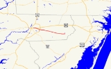
Maryland Route 350 is a state highway
in the U.S. state
of Maryland
. Known as Mount Hermon Road, the state highway runs 11.8 miles (19 km) from Main Street in Salisbury
east to MD 354
in Powellville
. MD 350 provides access to a large area of farmland and forest in southeastern Wicomico County
as well as Salisbury-Ocean City Wicomico Regional Airport. The state highway was constructed from Salisbury to Mount Hermon in the 1910s and from Mount Hermon to Powellville in the first half of the 1930s.
(US 50), runs through the intersection from southwest to northeast, while Long Avenue, Truitt Street, and William Street are the south, north, and west prongs of the junction, respectively. MD 350, which is maintained by the city of Salisbury for its first 0.18 mile (0.2896812 km), heads east as a four-lane undivided highway. The state highway parallels the partially controlled access
US 50 Business
(Salisbury Parkway) on the south and provides access to businesses situated between the two highways.
After the intersection with Beaglin Park Drive, a county arterial highway on the east side of Salisbury, MD 350 veers away from US 50 Business and reduces to a two-lane road. The state highway passes under US 13
(Salisbury Bypass) with no access and crosses Beaverdam Creek. MD 350 continues through the hamlet of Mount Hermon, where the highway intersects Hobbs Road and Airport Road, which leads to Salisbury-Ocean City Wicomico Regional Airport. The state highway passes through a mix of farmland and forest, traversing Horsebridge Creek, Gate Creek, and Nassawango Creek
in succession on the edge of the Wicomico Demonstration Forest
, which is accessed via Sixty Foot Road. MD 350 enters Powellville and reaches its eastern terminus at MD 354 (Powellville Road).
.
{| class=wikitable
!Location
!Mile
!Destinations
!Notes
|-
|Salisbury
|0.00
|Main Street / Long Avenue south / William Street west / Truitt Street north
|Western terminus; Main Street is old alignment of US 50
|-
|Mount Hermon
|3.34
|Airport Road south – Salisbury-Ocean City Wicomico Regional Airport
|Former MD 585
|-
|Powellville
|11.80
|
|Eastern terminus
State highway
State highway, state road or state route can refer to one of three related concepts, two of them related to a state or provincial government in a country that is divided into states or provinces :#A...
in the U.S. state
U.S. state
A U.S. state is any one of the 50 federated states of the United States of America that share sovereignty with the federal government. Because of this shared sovereignty, an American is a citizen both of the federal entity and of his or her state of domicile. Four states use the official title of...
of Maryland
Maryland
Maryland is a U.S. state located in the Mid Atlantic region of the United States, bordering Virginia, West Virginia, and the District of Columbia to its south and west; Pennsylvania to its north; and Delaware to its east...
. Known as Mount Hermon Road, the state highway runs 11.8 miles (19 km) from Main Street in Salisbury
Salisbury, Maryland
-Demographics:Salisbury is the principal city of the Salisbury-Ocean Pines CSA, a Combined Statistical Area that includes the Salisbury metropolitan area and the Ocean Pines micropolitan area , which had a combined population of 176,657 at the 2010 census.As of the census of 2000, there were...
east to MD 354
Maryland Route 354
Maryland Route 354 is a state highway in the U.S. state of Maryland. The state highway runs from MD 12 in Indiantown north to MD 346 in Willards. MD 354 parallels the Pocomoke River, connecting eastern Wicomico County and northwestern Worcester with Snow Hill. The state highway was first...
in Powellville
Powellville, Maryland
Powellville is an unincorporated community in Wicomico County, Maryland, United States.-References:...
. MD 350 provides access to a large area of farmland and forest in southeastern Wicomico County
Wicomico County, Maryland
As of the census of 2010, there were 98,733 people, 37,220 households, and 24,172 families residing in the county. The population density was 261.7 people per square mile . There were 41,192 housing units at an average density of 109.2 per square mile...
as well as Salisbury-Ocean City Wicomico Regional Airport. The state highway was constructed from Salisbury to Mount Hermon in the 1910s and from Mount Hermon to Powellville in the first half of the 1930s.
Route description
MD 350 begins as the east leg of a six-way intersection in Salisbury. Main Street, which was formerly U.S. Route 50U.S. Route 50 in Maryland
U.S. Route 50 is a major east–west route of the U.S. Highway system, stretching just over from Ocean City, Maryland on the Atlantic Ocean to West Sacramento, California. In the U.S. state of Maryland, US 50 exists in two sections. The longer of these serves as a major route connecting...
(US 50), runs through the intersection from southwest to northeast, while Long Avenue, Truitt Street, and William Street are the south, north, and west prongs of the junction, respectively. MD 350, which is maintained by the city of Salisbury for its first 0.18 mile (0.2896812 km), heads east as a four-lane undivided highway. The state highway parallels the partially controlled access
Limited-access road
A limited-access road known by various terms worldwide, including limited-access highway, dual-carriageway and expressway, is a highway or arterial road for high-speed traffic which has many or most characteristics of a controlled-access highway , including limited or no access to adjacent...
US 50 Business
U.S. Route 50 Business (Salisbury, Maryland)
U.S. Route 50 Business is a business route of U.S. Route 50 in the U.S. state of Maryland. The highway runs between US 50 on the northwest side of Salisbury and US 50 on the east side of Salisbury, the county seat of Wicomico County...
(Salisbury Parkway) on the south and provides access to businesses situated between the two highways.
After the intersection with Beaglin Park Drive, a county arterial highway on the east side of Salisbury, MD 350 veers away from US 50 Business and reduces to a two-lane road. The state highway passes under US 13
U.S. Route 13 in Maryland
U.S. Route 13 is a U.S. Highway running from Fayetteville, North Carolina north to Morrisville, Pennsylvania. In the U.S. state of Maryland, the route runs from the Virginia border south of Pocomoke City in Worcester County north to the Delaware border in Delmar, Wicomico County, where the route...
(Salisbury Bypass) with no access and crosses Beaverdam Creek. MD 350 continues through the hamlet of Mount Hermon, where the highway intersects Hobbs Road and Airport Road, which leads to Salisbury-Ocean City Wicomico Regional Airport. The state highway passes through a mix of farmland and forest, traversing Horsebridge Creek, Gate Creek, and Nassawango Creek
Nassawango Creek
Nassawango Creek is the largest tributary of the Pocomoke River, located on the Delmarva Peninsula. Older variations on the same name include Nassanongo, Naseongo, Nassiongo, and Nassiungo meaning "[ground] between [the streams]"; early English records have it as Askimenokonson Creek, after a...
in succession on the edge of the Wicomico Demonstration Forest
Wicomico Demonstration Forest
Wicomico Demonstration Forest is primarily forested land. This area is used by the Maryland Forest Service to demonstrate various timber management techniques and practices.-External links:**...
, which is accessed via Sixty Foot Road. MD 350 enters Powellville and reaches its eastern terminus at MD 354 (Powellville Road).
History
The first portion of MD 350 was constructed between Salisbury and Mount Hermon as a state-aid road by 1915; this highway was improved and brought into the state highway system by 1919. Work began on the Mount Hermon–Powellville portion of the highway in 1929. A small segment in Powellville and the section between Mount Hermon and Sixty Foot Road were completed by 1933. The gap between Sixty Foot Road and the west end of Powellville was closed in 1935.Junction list
The entire route is in Wicomico CountyWicomico County, Maryland
As of the census of 2010, there were 98,733 people, 37,220 households, and 24,172 families residing in the county. The population density was 261.7 people per square mile . There were 41,192 housing units at an average density of 109.2 per square mile...
.
{| class=wikitable
!Location
!Mile
!Destinations
!Notes
|-
|Salisbury
Salisbury, Maryland
-Demographics:Salisbury is the principal city of the Salisbury-Ocean Pines CSA, a Combined Statistical Area that includes the Salisbury metropolitan area and the Ocean Pines micropolitan area , which had a combined population of 176,657 at the 2010 census.As of the census of 2000, there were...
|0.00
|Main Street / Long Avenue south / William Street west / Truitt Street north
|Western terminus; Main Street is old alignment of US 50
|-
|Mount Hermon
|3.34
|Airport Road south – Salisbury-Ocean City Wicomico Regional Airport
|Former MD 585
|-
|Powellville
Powellville, Maryland
Powellville is an unincorporated community in Wicomico County, Maryland, United States.-References:...
|11.80
|
|Eastern terminus