
Maryland Route 287
Encyclopedia
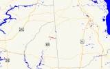
Maryland Route 287 is a state highway
in the U.S. state
of Maryland
. Known for much of its length as Sandtown Road, the state highway runs 2.88 miles (4.6 km) from MD 313
in Goldsboro
east to the Delaware
state line, where the highway continues east as Delaware Route 10
(DE 10). MD 287 was constructed in the early 1930s.
(Main Street) and crossing an unused railroad grade owned by the Maryland Department of Transportation
, the state highway's name changes to Sandtown Road and it heads east through farmland, crossing Broadway Branch and the upper part of the Choptank River
. MD 287 reaches its eastern terminus at the Delaware state line, where the highway continues east as DE 10 (Willow Grove Road) toward Dover.
in Caroline County
.
State highway
State highway, state road or state route can refer to one of three related concepts, two of them related to a state or provincial government in a country that is divided into states or provinces :#A...
in the U.S. state
U.S. state
A U.S. state is any one of the 50 federated states of the United States of America that share sovereignty with the federal government. Because of this shared sovereignty, an American is a citizen both of the federal entity and of his or her state of domicile. Four states use the official title of...
of Maryland
Maryland
Maryland is a U.S. state located in the Mid Atlantic region of the United States, bordering Virginia, West Virginia, and the District of Columbia to its south and west; Pennsylvania to its north; and Delaware to its east...
. Known for much of its length as Sandtown Road, the state highway runs 2.88 miles (4.6 km) from MD 313
Maryland Route 313
Maryland Route 313 is a state highway located on the Eastern Shore of Maryland in the United States. The route runs from U.S. Route 50 in Mardela Springs, Wicomico County north to Maryland Route 213 and Maryland Route 290 in Galena, Kent County...
in Goldsboro
Goldsboro, Maryland
Goldsboro is a town in Caroline County, Maryland, United States. The population was 216 at the 2000 census. The zipcode is 21636. It is named after Thomas Alan Goldsborough...
east to the Delaware
Delaware
Delaware is a U.S. state located on the Atlantic Coast in the Mid-Atlantic region of the United States. It is bordered to the south and west by Maryland, and to the north by Pennsylvania...
state line, where the highway continues east as Delaware Route 10
Delaware Route 10
Delaware Route 10 is a state highway in Kent County, Delaware. It runs from Maryland Route 287 at the Maryland border in Sandtown east to an interchange with Delaware Route 1 at the north gate of Dover Air Force Base. The route passes through the towns of Camden and Wyoming along the way. It is a...
(DE 10). MD 287 was constructed in the early 1930s.
Route description
MD 287 begins at an intersection with MD 313 on the northwest edge of Goldsboro. MD 313 heads south into the town as Oldtown Road and west as Goldsboro Road. MD 287 heads east as Old Line Road along the northern edge of Goldsboro. After intersecting MD 311Maryland Route 311
Maryland Route 311 is a state highway in the U.S. state of Maryland. Known for most of its length as Henderson Road, the state highway runs from MD 313 in Goldsboro north to MD 454 in Marydel. MD 311 was constructed in the mid 1920s...
(Main Street) and crossing an unused railroad grade owned by the Maryland Department of Transportation
Maryland Department of Transportation
The Maryland Department of Transportation is a government agency in the U.S. state of Maryland. MDOT is overseen by Transportation Secretary Beverley K. Swaim-Staley, who replaced John Porcari in 2009 upon the latter's appointment as Deputy Secretary of the United States Department of...
, the state highway's name changes to Sandtown Road and it heads east through farmland, crossing Broadway Branch and the upper part of the Choptank River
Choptank River
The Choptank River is a major tributary of the Chesapeake Bay on the Delmarva Peninsula. Running for , it rises in Kent County, Delaware, runs through Caroline County, Maryland and forms much of the border between Talbot County, Maryland on the north, and Caroline County and Dorchester County on...
. MD 287 reaches its eastern terminus at the Delaware state line, where the highway continues east as DE 10 (Willow Grove Road) toward Dover.
Junction list
The entire route is in GoldsboroGoldsboro, Maryland
Goldsboro is a town in Caroline County, Maryland, United States. The population was 216 at the 2000 census. The zipcode is 21636. It is named after Thomas Alan Goldsborough...
in Caroline County
Caroline County, Maryland
Caroline County is a wholly rural county located in the U.S. state of Maryland on its Eastern Shore. It is bordered by Queen Anne's County to the north, Talbot County to the west, Dorchester County to the south, Kent County, Delaware, to the east, and Sussex County, Delaware, to the southeast. As...
.
| Mile |
Destinations | Notes |
|---|---|---|
| 0.00 | Western terminus | |
| 0.29 | ||
| 2.88 | – Dover Dover, Delaware The city of Dover is the capital and second largest city in the U.S. state of Delaware. It is also the county seat of Kent County, and the principal city of the Dover, Delaware Metropolitan Statistical Area, which encompasses all of Kent County. It is located on the St. Jones River in the Delaware... |
Eastern terminus |