
Maryland Route 146
Encyclopedia
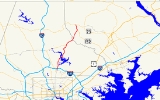
Maryland Route 146 is a state highway
in the U.S. state of Maryland
. The state highway runs 16.81 miles (27.1 km) from MD 45
in Towson
north to MD 23
near Jarrettsville
. MD 146 connects Towson with Loch Raven Reservoir
, an impoundment of Gunpowder Falls. The state highway also serves the northern Baltimore County
community of Jacksonville and Jarrettsville in western Harford County
. MD 146 was constructed as two different state highways on either side of Loch Raven Reservoir. The section of the state highway in Towson was built in the 1910s and the portion through Jacksonville to Jarrettsville was constructed in the late 1920s and early 1930s. The gap in MD 146 through Loch Raven Reservoir was filled in two steps of maintenance swaps in the early 1960s and late 1970s.
in the center of Towson. The roundabout also features MD 45 (York Road), which heads south toward Baltimore and northwest toward Lutherville, and Joppa Road, a county-maintained highway that runs west toward Brooklandville
and east toward Parkville
. MD 146 heads northeast as Dulaney Valley Road, a four-lane divided boulevard that passes along the west side of Towson Town Center
and the campus of Goucher College
. The state highway meets Interstate 695
(Baltimore Beltway) at a partial cloverleaf interchange. The ramp from the westbound Beltway to MD 146 connects via Hampton Lane, which heads east past Towson United Methodist Church
toward Hampton National Historic Site
. North of the Beltway, MD 146 is a five-lane road with center turn lane that passes between the suburbs of Hampton, Maryland
to the east and Lutherville to the west. MD 146 reduces to two lanes just north of Seminary Road and its traversal of Long Quarter Branch, which flows into Loch Raven Reservoir. The state highway passes between Timonium to the west and the reservoir parkland on the east.
North of Timonium Road, MD 146 fully enters Loch Raven Reservoir Park. At Old Bosley Road, the state highway curves east and crosses the reservoir. Just east of the bridge, Dulaney Valley Road continues east while MD 146 veers north as Jarrettsville Pike. The state highway passes by the historic home Eagle's Nest
as it leaves the reservoir valley. MD 146 intersects Sunnybrook Road and Merrymans Mill Road in the hamlet of Sunnybrook before passing through Jacksonville, a community also known as Phoenix that is centered at the highway's intersection with MD 145
. MD 145 heads east as Sweet Air Road toward Baldwin
and west as Paper Mill Road toward Cockeysville
. North of Jacksonville, MD 146 crosses Little Gunpowder Falls into Harford County. The state highway passes through the communities of Hess and Taylor, where the highway passes the Ladew Topiary Gardens
and meets the northern end of MD 152
(Fallston Road). MD 146 reaches its northern terminus at its intersection with MD 23 (Norrisville Road) in the hamlet of Madonna west of Jarrettsville. The roadway continues north as county-maintained Madonna Road.
.jpg) MD 146's predecessor highways included a pair of turnpikes. The Dulaney's Valley and Towsontown Turnpike connected the Baltimore and Yorktown Turnpike at Towson with Meredith's Ford, a shallow spot in Gunpowder Falls before Loch Raven Reservoir was formed. A pair of turnpikes began east of the ford
MD 146's predecessor highways included a pair of turnpikes. The Dulaney's Valley and Towsontown Turnpike connected the Baltimore and Yorktown Turnpike at Towson with Meredith's Ford, a shallow spot in Gunpowder Falls before Loch Raven Reservoir was formed. A pair of turnpikes began east of the ford
: the Dulaney's Valley and Sweet Air Turnpike east to the community of Knoebel at what is now the intersection of Dulaney Valley Road and Manor Road, and the Jarrettsville Turnpike north from the ford through Jacksonville to Little Gunpowder Falls. The first section of modern MD 146 was constructed as a 14 feet (4.3 m) wide macadam road from York Road north 0.5 mile (0.80467 km) in 1915. This road was resurfaced in concrete and extended to the southern edge of the Loch Raven Reservoir reservation just north of Seminary Road by 1921.
The first portion of MD 146 north of Loch Raven Reservoir was a concrete road from the northern edge of the Loch Raven Reservoir reservation to MD 145 in Jacksonville built in 1928. The state highway was extended north to Little Gunpowder Falls in 1929. The Harford County section of MD 146 was started in 1930 and completed in 1932. An additional section of the state highway was built on Madonna Road from the junction with MD 23 north to Nelson Mill Road in 1939. MD 146 was truncated at MD 23 when the Madonna Road segment was transferred to county maintenance in 1955. The section of the state highway south of Loch Raven Reservoir was originally designated MD 144 but became a disjoint segment of MD 146 by 1940. MD 144
was later reused for bypassed sections of U.S. Route 40
between Cumberland
and Baltimore.
The southern segment of MD 146 was widened to 18 feet (5.5 m) in 1946. MD 146 from the center of Towson to the Baltimore Beltway was expanded to a divided highway concurrent with the construction of the highway's cloverleaf interchange
with the Beltway between 1955 and 1958. The portions of Dulaney Valley Road and Jarrettsville Pike through the Loch Raven Reservoir reservation were originally maintained by the Baltimore City Department of Transportation since the reservoir is owned by the city of Baltimore. These sections were transferred to state maintenance in two steps. MD 146 was extended north from near Seminary Road to just west of the bridge over the reservoir in 1963. The bridge and the highway to the northern edge of the reservoir reservation were transferred to state maintenance in 1979, closing the gap between the two sections of MD 146.
!County
!Location
!Mile
!Destinations
!Notes
|-
|rowspan=4|Baltimore
|rowspan=2|Towson
|0.00
|
|Southern terminus; Towson Roundabout
|-
|0.78
|
|I-695 Exit 27
|-
|Loch Raven Reservoir
|4.99
|Dulaney Valley Road east
|MD 146 continues north as Jarrettsville Pike; Dulaney Valley Road is unsigned MD 146A
|-
|Jacksonville
|9.24
|
|
|-
|rowspan=2|Harford
|Taylor
|15.13
|
|
|-
|Jarrettsville
|16.81
|
|Northern terminus
State highway
State highway, state road or state route can refer to one of three related concepts, two of them related to a state or provincial government in a country that is divided into states or provinces :#A...
in the U.S. state of Maryland
Maryland
Maryland is a U.S. state located in the Mid Atlantic region of the United States, bordering Virginia, West Virginia, and the District of Columbia to its south and west; Pennsylvania to its north; and Delaware to its east...
. The state highway runs 16.81 miles (27.1 km) from MD 45
Maryland Route 45
Maryland Route 45 is a state highway in the U.S. state of Maryland. Known for most of its length as York Road, the state highway runs from U.S. Route 1 in Baltimore north to the Pennsylvania state line in Maryland Line, where the highway continues as SR 3001...
in Towson
Towson, Maryland
Towson is an unincorporated community and a census-designated place in Baltimore County, Maryland, United States. The population was 55,197 at the 2010 census...
north to MD 23
Maryland Route 23
Maryland Route 23 is a state highway in the U.S. state of Maryland. The state highway runs from U.S. Route 1 in Hickory north and west to the Pennsylvania state line near Norrisville, where the highway continues as Pennsylvania Route 24 . MD 23 is an L-shaped highway in northwestern Harford...
near Jarrettsville
Jarrettsville, Maryland
Jarrettsville is a census-designated place in Harford County, Maryland, United States. The population was 2,756 at the 2000 census.-History:...
. MD 146 connects Towson with Loch Raven Reservoir
Loch Raven Reservoir
The Loch Raven Reservoir is a reservoir that provides drinking water for the City of Baltimore and most of Baltimore County, Maryland. Originally built in 1881 as a dam and water tunnel to channel water to Lake Montebello and Lake Clifton, the new dam was constructed in 1914 in efforts to increase...
, an impoundment of Gunpowder Falls. The state highway also serves the northern Baltimore County
Baltimore County, Maryland
Baltimore County is a county located in the northern part of the US state of Maryland. In 2010, its population was 805,029. It is part of the Baltimore-Washington Metropolitan Area. Its county seat is Towson. The name of the county was derived from the barony of the Proprietor of the Maryland...
community of Jacksonville and Jarrettsville in western Harford County
Harford County, Maryland
Harford County is a county in the U.S. state of Maryland. In 2010, its population was 244,826. Its county seat is Bel Air. Harford County forms part of the Baltimore-Washington Metropolitan Area.-History:...
. MD 146 was constructed as two different state highways on either side of Loch Raven Reservoir. The section of the state highway in Towson was built in the 1910s and the portion through Jacksonville to Jarrettsville was constructed in the late 1920s and early 1930s. The gap in MD 146 through Loch Raven Reservoir was filled in two steps of maintenance swaps in the early 1960s and late 1970s.
Route description
MD 146 begins at the Towson Roundabout, a five-leg, racetrack-shaped roundaboutRoundabout
A roundabout is the name for a road junction in which traffic moves in one direction around a central island. The word dates from the early 20th century. Roundabouts are common in many countries around the world...
in the center of Towson. The roundabout also features MD 45 (York Road), which heads south toward Baltimore and northwest toward Lutherville, and Joppa Road, a county-maintained highway that runs west toward Brooklandville
Brooklandville, Maryland
Brooklandville is an unincorporated community in Baltimore County, Maryland, United States near where the Jones Falls Expressway meets the Baltimore Beltway. The general area is a part of Lutherville, and some addresses in the area are considered to be in Lutherville, though Brooklandville has a...
and east toward Parkville
Parkville, Maryland
-Demographics:As of the census of 2000, there were 31,118 people, 13,044 households, and 8,243 families residing in the CDP. The population density was 7,352.1 people per square mile . There were 13,550 housing units at an average density of 3,201.4 per square mile...
. MD 146 heads northeast as Dulaney Valley Road, a four-lane divided boulevard that passes along the west side of Towson Town Center
Towson Town Center
Towson Town Center is a large indoor shopping mall located in Towson, Maryland. It was the largest indoor shopping mall in Maryland prior to the completion of Arundel Mills in late 2000 in Hanover and the 2007 expansion of the Annapolis Mall.- History :...
and the campus of Goucher College
Goucher College
Goucher College is a private, co-educational, liberal arts college located in the northern Baltimore suburb of Towson in unincorporated Baltimore County, Maryland, on a 287 acre campus. The school has approximately 1,475 undergraduate students studying in 31 majors and six interdisciplinary...
. The state highway meets Interstate 695
Interstate 695 (Maryland)
Interstate 695 is a -long full beltway Interstate Highway extending around Baltimore, Maryland, USA. I-695 is officially designated the McKeldin Beltway, but is colloquially referred to as either the Baltimore Beltway or 695...
(Baltimore Beltway) at a partial cloverleaf interchange. The ramp from the westbound Beltway to MD 146 connects via Hampton Lane, which heads east past Towson United Methodist Church
Towson United Methodist Church
Towson United Methodist Church is a large United Methodist Church in the historic Baltimore County, Maryland suburb of Towson. Its past, rooted in 19th century America, and subsequent growth in the two centuries since then, have closely paralleled the nation's political and sociological trends...
toward Hampton National Historic Site
Hampton National Historic Site
Hampton National Historic Site, in the Hampton area north of Towson, Baltimore County, Maryland, United States, preserves a remnant of a vast 18th-century estate, including a Georgian manor house, gardens, grounds, and the original stone slave quarters. The estate was owned by the Ridgely family...
. North of the Beltway, MD 146 is a five-lane road with center turn lane that passes between the suburbs of Hampton, Maryland
Hampton, Maryland
Hampton is an unincorporated community and a census-designated place in Baltimore County, Maryland. The population was 5,004 at the 2000 census. Hampton is often considered a subdivision of the nearby community of Towson and is located just north of Baltimore City, Maryland, about twenty minutes...
to the east and Lutherville to the west. MD 146 reduces to two lanes just north of Seminary Road and its traversal of Long Quarter Branch, which flows into Loch Raven Reservoir. The state highway passes between Timonium to the west and the reservoir parkland on the east.
North of Timonium Road, MD 146 fully enters Loch Raven Reservoir Park. At Old Bosley Road, the state highway curves east and crosses the reservoir. Just east of the bridge, Dulaney Valley Road continues east while MD 146 veers north as Jarrettsville Pike. The state highway passes by the historic home Eagle's Nest
Eagle's Nest (Phoenix, Maryland)
Eagle's Nest is a historic home located at Phoenix, Baltimore County, Maryland. It is a large fieldstone dwelling completed in 1802 on part of tract called "Valley of Jehosaphat." The three-part house consists of: a tall, -story 5-bay-long portion, and two long -story portions...
as it leaves the reservoir valley. MD 146 intersects Sunnybrook Road and Merrymans Mill Road in the hamlet of Sunnybrook before passing through Jacksonville, a community also known as Phoenix that is centered at the highway's intersection with MD 145
Maryland Route 145
Maryland Route 145 is a state highway in the U.S. state of Maryland. The state highway runs from MD 45 in Hunt Valley east to MD 165 near Baldwin. MD 145 connects the north-central and eastern portions of Baltimore County via Jacksonville. The first section of the highway was built from Loch...
. MD 145 heads east as Sweet Air Road toward Baldwin
Baldwin, Maryland
Baldwin is an unincorporated community in Baltimore County, Maryland, United States. The United States Postal Service has assigned Baldwin the ZIP Code 21013. Until 1958, this community was served by the Maryland and Pennsylvania Railroad at milepost 18.4. Hidden Valley Farm was listed on the...
and west as Paper Mill Road toward Cockeysville
Cockeysville, Maryland
Cockeysville is a census-designated place in Baltimore County, Maryland, United States. The population was 19,388 at the 2000 census.-History:...
. North of Jacksonville, MD 146 crosses Little Gunpowder Falls into Harford County. The state highway passes through the communities of Hess and Taylor, where the highway passes the Ladew Topiary Gardens
Ladew Topiary Gardens
Ladew Topiary Gardens are nonprofit gardens with topiary located at 3535 Jarrettsville Pike, Monkton, Maryland. The house and gardens are open April through October weekdays and weekends; an admission fee is charged. The gardens were established in the 1930s by socialite and huntsman Harvey S...
and meets the northern end of MD 152
Maryland Route 152
Maryland Route 152 is a state highway in the U.S. state of Maryland. The state highway runs from an entrance to Aberdeen Proving Ground in Magnolia north to MD 146 near Taylor. MD 152 parallels the western edge of Harford County, connecting the communities of Joppatowne and Fallston with...
(Fallston Road). MD 146 reaches its northern terminus at its intersection with MD 23 (Norrisville Road) in the hamlet of Madonna west of Jarrettsville. The roadway continues north as county-maintained Madonna Road.
History
Ford (crossing)
A ford is a shallow place with good footing where a river or stream may be crossed by wading or in a vehicle. A ford is mostly a natural phenomenon, in contrast to a low water crossing, which is an artificial bridge that allows crossing a river or stream when water is low.The names of many towns...
: the Dulaney's Valley and Sweet Air Turnpike east to the community of Knoebel at what is now the intersection of Dulaney Valley Road and Manor Road, and the Jarrettsville Turnpike north from the ford through Jacksonville to Little Gunpowder Falls. The first section of modern MD 146 was constructed as a 14 feet (4.3 m) wide macadam road from York Road north 0.5 mile (0.80467 km) in 1915. This road was resurfaced in concrete and extended to the southern edge of the Loch Raven Reservoir reservation just north of Seminary Road by 1921.
The first portion of MD 146 north of Loch Raven Reservoir was a concrete road from the northern edge of the Loch Raven Reservoir reservation to MD 145 in Jacksonville built in 1928. The state highway was extended north to Little Gunpowder Falls in 1929. The Harford County section of MD 146 was started in 1930 and completed in 1932. An additional section of the state highway was built on Madonna Road from the junction with MD 23 north to Nelson Mill Road in 1939. MD 146 was truncated at MD 23 when the Madonna Road segment was transferred to county maintenance in 1955. The section of the state highway south of Loch Raven Reservoir was originally designated MD 144 but became a disjoint segment of MD 146 by 1940. MD 144
Maryland Route 144
Maryland Route 144 is a collection of state highways in the U.S. state of Maryland. These highways are sections of old alignment of U.S. Route 40 between Cumberland and Baltimore...
was later reused for bypassed sections of U.S. Route 40
U.S. Route 40 in Maryland
U.S. Route 40 in the U.S. state of Maryland runs from western Maryland to Cecil County in the state's northeastern corner. With a total length of over , it is the longest numbered highway in Maryland. Almost half of the road overlaps with Interstate 68 or Interstate 70, while the old alignment...
between Cumberland
Cumberland, Maryland
Cumberland is a city in the far western, Appalachian portion of Maryland, United States. It is the county seat of Allegany County, and the primary city of the Cumberland, MD-WV Metropolitan Statistical Area. At the 2010 census, the city had a population of 20,859, and the metropolitan area had a...
and Baltimore.
The southern segment of MD 146 was widened to 18 feet (5.5 m) in 1946. MD 146 from the center of Towson to the Baltimore Beltway was expanded to a divided highway concurrent with the construction of the highway's cloverleaf interchange
Cloverleaf interchange
A cloverleaf interchange is a two-level interchange in which left turns, reverse direction in left-driving regions, are handled by ramp roads...
with the Beltway between 1955 and 1958. The portions of Dulaney Valley Road and Jarrettsville Pike through the Loch Raven Reservoir reservation were originally maintained by the Baltimore City Department of Transportation since the reservoir is owned by the city of Baltimore. These sections were transferred to state maintenance in two steps. MD 146 was extended north from near Seminary Road to just west of the bridge over the reservoir in 1963. The bridge and the highway to the northern edge of the reservoir reservation were transferred to state maintenance in 1979, closing the gap between the two sections of MD 146.
Junction list
{|class=wikitable!County
!Location
!Mile
!Destinations
!Notes
|-
|rowspan=4|Baltimore
Baltimore County, Maryland
Baltimore County is a county located in the northern part of the US state of Maryland. In 2010, its population was 805,029. It is part of the Baltimore-Washington Metropolitan Area. Its county seat is Towson. The name of the county was derived from the barony of the Proprietor of the Maryland...
|rowspan=2|Towson
Towson, Maryland
Towson is an unincorporated community and a census-designated place in Baltimore County, Maryland, United States. The population was 55,197 at the 2010 census...
|0.00
|
|Southern terminus; Towson Roundabout
Roundabout
A roundabout is the name for a road junction in which traffic moves in one direction around a central island. The word dates from the early 20th century. Roundabouts are common in many countries around the world...
|-
|0.78
|
|I-695 Exit 27
|-
|Loch Raven Reservoir
Loch Raven Reservoir
The Loch Raven Reservoir is a reservoir that provides drinking water for the City of Baltimore and most of Baltimore County, Maryland. Originally built in 1881 as a dam and water tunnel to channel water to Lake Montebello and Lake Clifton, the new dam was constructed in 1914 in efforts to increase...
|4.99
|Dulaney Valley Road east
|MD 146 continues north as Jarrettsville Pike; Dulaney Valley Road is unsigned MD 146A
|-
|Jacksonville
|9.24
|
|
|-
|rowspan=2|Harford
Harford County, Maryland
Harford County is a county in the U.S. state of Maryland. In 2010, its population was 244,826. Its county seat is Bel Air. Harford County forms part of the Baltimore-Washington Metropolitan Area.-History:...
|Taylor
Taylor, Maryland
Taylor is an unincorporated community in Harford County, Maryland, United States. Ladew Topiary Gardens and House was listed on the National Register of Historic Places in 1976.-References:...
|15.13
|
|
|-
|Jarrettsville
Jarrettsville, Maryland
Jarrettsville is a census-designated place in Harford County, Maryland, United States. The population was 2,756 at the 2000 census.-History:...
|16.81
|
|Northern terminus