

Martyrs Bridge (Bamako)
Encyclopedia
Bamako
Bamako is the capital of Mali and its largest city with a population of 1.8 million . Currently, it is estimated to be the fastest growing city in Africa and sixth fastest in the world...
Mali
Mali
Mali , officially the Republic of Mali , is a landlocked country in Western Africa. Mali borders Algeria on the north, Niger on the east, Burkina Faso and the Côte d'Ivoire on the south, Guinea on the south-west, and Senegal and Mauritania on the west. Its size is just over 1,240,000 km² with...
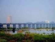
connects the older sections of the Malian capital to its broad suburbs on the south shore of the Niger River
Niger River
The Niger River is the principal river of western Africa, extending about . Its drainage basin is in area. Its source is in the Guinea Highlands in southeastern Guinea...
. One of two road bridges across the Niger at Bamako, it is also known as the "Old Bridge". Opened in 1957 when Mali was under French Colonial rule
French West Africa
French West Africa was a federation of eight French colonial territories in Africa: Mauritania, Senegal, French Sudan , French Guinea , Côte d'Ivoire , Upper Volta , Dahomey and Niger...
it was renamed the Martyrs Bridge after independence in 1961. Martyrs Bridge connects two of the main avenues of the city. Avenue Fluve (also known as Avenue Modibo Keita), a broad boulevard enclosing the Square Lamumba which runs north towards the Presidential palace. From the south of the bridge runs Avenue de l'Unite Africain, the major route from the city centre south to Bamako-Senou Airport
Senou International Airport
-Accidents and incidents:*On 24 July 1971, Douglas C-47A 6V-AAP of Air Ivoire crashed into a hill shortly after take-off. The aircraft was operating a scheduled passenger flight. All six people on board were killed.-Traffic and statistics:...
.
Other crossings
In 1982 a second road bridge, the King Fahd BridgeKing Fahd Bridge (Bamako)
The King Fahd Bridge of Bamako Mali connects the older sections of the Malian capitol to its broad suburbs on the south shore of the Niger River....
, was opened just 500 meters upstream. Both bridges connect the central city neighborhood of Commune III with Badalabougou.
Prior to the 1950s, the only crossing of the Niger at Bamako was at the Stroba Causeway, 8 kilometers downstream from the city, which is a low water crossing of cut stone at the location of a natural rapids. The Airgrettes Dam, 200 kilometers upstream, is a hydroelectric station and the next all season crossing to the west. The next all season crossing downstream is at the Markala Dam, over 200 kilometers east northeast past Segou
Ségou
Ségou is a city in south-central Mali, lying northeast of Bamako on the River Niger, in the region of Ségou. It was founded by the Bozo people, on a site about from the present town...
, which until recently relied on ferry transport to cross one arm of the Niger. The next road bridge to cross the Niger river downstream of Markala
Markala
Markala is a city in Mali's Ségou Region on the Niger River, 35 km downriver from the city of Ségou. Markala is the site of Mali's primary irrigation dam....
is at Gao
Gao
Gao is a town in eastern Mali on the River Niger lying ESE of Timbuktu. Situated on the left bank of the river at the junction with the Tilemsi valley, it is the capital of the Gao Region and had a population of 86,663 in 2009....
, Mali
Mali
Mali , officially the Republic of Mali , is a landlocked country in Western Africa. Mali borders Algeria on the north, Niger on the east, Burkina Faso and the Côte d'Ivoire on the south, Guinea on the south-west, and Senegal and Mauritania on the west. Its size is just over 1,240,000 km² with...
. A Chinese funded third road bridge, downstream on the east end of Bamako, is in the planning stage.