
Marshallton, Delaware
Encyclopedia
Marshallton is an unincorporated community
in Mill Creek Hundred
, New Castle County
, Delaware
, United States
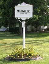
. The community was founded in 1836 and is named for John Marshall, mill owner.
, on Delaware State Highway 2. Marshallton is located along Red Clay Creek
; 39°44'N 75°38'W. Delaware Park
Horse Racing Track to SW.
ordered his army to fall back toward Red Clay Creek
during the wee hours of the morning. Here, Washington arranged his troops for battle. The troops immediately dug in, building redoubts and entrenchments. Cannons were placed on a rise "for half a mile as thick as they could stand." The new encampment covered a triangular area with the towns of Newport
, Marshallton, and Stanton
forming the connecting points.
Unincorporated area
In law, an unincorporated area is a region of land that is not a part of any municipality.To "incorporate" in this context means to form a municipal corporation, a city, town, or village with its own government. An unincorporated community is usually not subject to or taxed by a municipal government...
in Mill Creek Hundred
Mill Creek Hundred
Mill Creek Hundred is the name of an unincorporated subdivision of New Castle County, Delaware. Hundreds were once used as a basis for representation in the Delaware General Assembly, and while their names still appear on all real estate transactions, they presently have no meaningful use or...
, New Castle County
New Castle County, Delaware
New Castle County is the northernmost of the three counties of the U.S. state of Delaware. As of 2010 its population was 538,479, an increase of 7.6% over the previous decade. The county seat is Wilmington. The center of population of Delaware is located in New Castle County, in the town of...
, Delaware
Delaware
Delaware is a U.S. state located on the Atlantic Coast in the Mid-Atlantic region of the United States. It is bordered to the south and west by Maryland, and to the north by Pennsylvania...
, United States
United States
The United States of America is a federal constitutional republic comprising fifty states and a federal district...
. The community was founded in 1836 and is named for John Marshall, mill owner.
Geography
Marshallton is a residential suburb 5 mi/8 km W of WilmingtonWilmington, Delaware
Wilmington is the largest city in the state of Delaware, United States, and is located at the confluence of the Christina River and Brandywine Creek, near where the Christina flows into the Delaware River. It is the county seat of New Castle County and one of the major cities in the Delaware Valley...
, on Delaware State Highway 2. Marshallton is located along Red Clay Creek
Red Clay Creek
Red Clay Creek is a tributary of White Clay Creek in southeastern Pennsylvania and northern Delaware in the United States.The East and West branches both rise in West Marlborough Township, Pennsylvania, near the hamlet of Upland, and flow south through Kennett Square before uniting just north of...
; 39°44'N 75°38'W. Delaware Park
Delaware Park (race track)
Delaware Park is an American horse racing track, casino, and golf course in Stanton, Delaware. It is located just outside the city of Wilmington, and about thirty miles from Philadelphia.-Thoroughbred racing:...
Horse Racing Track to SW.
History
On August 30, 1777 George WashingtonGeorge Washington
George Washington was the dominant military and political leader of the new United States of America from 1775 to 1799. He led the American victory over Great Britain in the American Revolutionary War as commander-in-chief of the Continental Army from 1775 to 1783, and presided over the writing of...
ordered his army to fall back toward Red Clay Creek
Red Clay Creek
Red Clay Creek is a tributary of White Clay Creek in southeastern Pennsylvania and northern Delaware in the United States.The East and West branches both rise in West Marlborough Township, Pennsylvania, near the hamlet of Upland, and flow south through Kennett Square before uniting just north of...
during the wee hours of the morning. Here, Washington arranged his troops for battle. The troops immediately dug in, building redoubts and entrenchments. Cannons were placed on a rise "for half a mile as thick as they could stand." The new encampment covered a triangular area with the towns of Newport
Newport, Delaware
Newport is a town in New Castle County, Delaware, United States. It is located on the Christina River. It is best known for being the home of colonial inventor Oliver Evans. The population was 1,055 at the 2010 census...
, Marshallton, and Stanton
Stanton, Delaware
Stanton is an unincorporated community in New Castle County, Delaware, United States, near the confluence of the Red Clay and White Clay Creeks. It is located in the southern end of Mill Creek Hundred.-History:...
forming the connecting points.
See also
- List of Registered Historic Places in New Castle County, Delaware
- Wilmington and Western Railroad